40 knots
10W TEN 180704 1200 12.6N 145.4E WPAC 40 993
WPAC: MARIA - Post-Tropical
Moderator: S2k Moderators
-
mrbagyo

- Category 5

- Posts: 3963
- Age: 33
- Joined: Thu Apr 12, 2012 9:18 am
- Location: 14.13N 120.98E
- Contact:
Re: WPAC: MARIA - Tropical Storm
0 likes
The posts in this forum are NOT official forecast and should not be used as such. They are just the opinion of the poster and may or may not be backed by sound meteorological data. They are NOT endorsed by any professional institution or storm2k.org. For official information, please refer to RSMC, NHC and NWS products.
-
1900hurricane

- Category 5
- Posts: 6063
- Age: 34
- Joined: Fri Feb 06, 2015 12:04 pm
- Location: Houston, TX
- Contact:
Re: WPAC: MARIA - Tropical Storm
2 likes
Contract Meteorologist. TAMU & MSST. Fiercely authentic, one of a kind. We are all given free will, so choose a life meant to be lived. We are the Masters of our own Stories.
Opinions expressed are mine alone.
Follow me on Twitter at @1900hurricane : Read blogs at https://1900hurricane.wordpress.com/
Opinions expressed are mine alone.
Follow me on Twitter at @1900hurricane : Read blogs at https://1900hurricane.wordpress.com/
-
mrbagyo
- Category 5
- Posts: 3963
- Age: 33
- Joined: Thu Apr 12, 2012 9:18 am
- Location: 14.13N 120.98E
- Contact:
Re: WPAC: MARIA - Tropical Storm
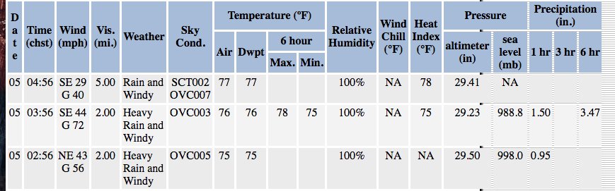
Still dropping. 996.6
47knots gust.
METAR: PGUA 041722Z 05036G47KT 10SM +RA FEW001 OVC005 24/24 A2946 RMK AO2A VIS 1/4 RWY06L VIS 1/8 RWY24L VIS M1/8 RWY24R PRESFR SLP966 RVRNO CHINO RWY24L $
UW - CIMSS ADVANCED DVORAK TECHNIQUE ADT-Version 9.0 Tropical Cyclone Intensity Algorithm ----- Current Analysis ----- Date : 04 JUL 2018 Time : 164000 UTC Lat : 13:03:57 N Lon : 144:44:20 E
CI# /Pressure/ Vmax
3.2 / 996.5mb/ 49.0kt
Final T# Adj T# Raw T# 3.2 3.4 3.4 Center Temp : -73.6C Cloud Region Temp : -71.5C Scene Type : UNIFORM CDO CLOUD REGION Subtropical Adjustment : OFF Extratropical Adjustment : OFF Positioning Method : FORECAST INTERPOLATION Ocean Basin : WEST PACIFIC Dvorak CI > MSLP Conversion Used : CKZ Method Tno/CI Rules : Constraint Limits : NO LIMIT Weakening Flag : OFF Rapid Dissipation Flag : OFF C/K/Z MSLP Estimate Inputs : - Average 34 knot radii : 53km - Environmental MSLP : 1008mb Satellite Name : HIM-8 Satellite Viewing Angle : 16.0 degrees
0 likes
The posts in this forum are NOT official forecast and should not be used as such. They are just the opinion of the poster and may or may not be backed by sound meteorological data. They are NOT endorsed by any professional institution or storm2k.org. For official information, please refer to RSMC, NHC and NWS products.
-
mrbagyo
- Category 5
- Posts: 3963
- Age: 33
- Joined: Thu Apr 12, 2012 9:18 am
- Location: 14.13N 120.98E
- Contact:
Re: WPAC: MARIA - Tropical Storm
Droppin droppin 
993.2
METAR: PGUA 041737Z 04041G55KT 10SM +RA OVC004 24/24 A2936 RMK AO2A VIS 1/8 RWY06L VIS M1/8 RWY24L VIS M1/8 RWY24R PRESFR SLP932 RVRNO CHINO RWY24L $
993.2
METAR: PGUA 041737Z 04041G55KT 10SM +RA OVC004 24/24 A2936 RMK AO2A VIS 1/8 RWY06L VIS M1/8 RWY24L VIS M1/8 RWY24R PRESFR SLP932 RVRNO CHINO RWY24L $
0 likes
The posts in this forum are NOT official forecast and should not be used as such. They are just the opinion of the poster and may or may not be backed by sound meteorological data. They are NOT endorsed by any professional institution or storm2k.org. For official information, please refer to RSMC, NHC and NWS products.
-
mrbagyo
- Category 5
- Posts: 3963
- Age: 33
- Joined: Thu Apr 12, 2012 9:18 am
- Location: 14.13N 120.98E
- Contact:
Re: WPAC: MARIA - Tropical Storm
Freakin Insanity - pressure knida free all
984.0mb!!!
METAR: PGUA 041750Z 10022G63KT 2SM +RA OVC003 24/24 A2909 RMK AO2A WSHFT 48 VIS 1/8 RWY06L VIS 1/4 RWY24L VIS 1/8 RWY24R SLP840 RVRNO CHINO RWY24L $
984.0mb!!!
METAR: PGUA 041750Z 10022G63KT 2SM +RA OVC003 24/24 A2909 RMK AO2A WSHFT 48 VIS 1/8 RWY06L VIS 1/4 RWY24L VIS 1/8 RWY24R SLP840 RVRNO CHINO RWY24L $
0 likes
The posts in this forum are NOT official forecast and should not be used as such. They are just the opinion of the poster and may or may not be backed by sound meteorological data. They are NOT endorsed by any professional institution or storm2k.org. For official information, please refer to RSMC, NHC and NWS products.
Re: WPAC: MARIA - Tropical Storm
PGUA's observations look a bit weird to me, in particular the rate of pressure change.
0 likes
Personal Forecast Disclaimer:
The posts in this forum are NOT official forecast and should not be used as such. They are just the opinion of the poster and may or may not be backed by sound meteorological data. They are NOT endorsed by any professional institution or storm2k.org. For official information, please refer to RSMC and NWS products.
The posts in this forum are NOT official forecast and should not be used as such. They are just the opinion of the poster and may or may not be backed by sound meteorological data. They are NOT endorsed by any professional institution or storm2k.org. For official information, please refer to RSMC and NWS products.
-
SouthDadeFish

- Professional-Met

- Posts: 2835
- Joined: Thu Sep 23, 2010 2:54 pm
- Location: Miami, FL
- Contact:
Re: WPAC: MARIA - Tropical Storm
It's a shame it appears the radar has stopped working. The last radar frames look like the mesovortex was becoming the dominant center of the TC, with a potential eyewall forming.
1 likes
-
mrbagyo
- Category 5
- Posts: 3963
- Age: 33
- Joined: Thu Apr 12, 2012 9:18 am
- Location: 14.13N 120.98E
- Contact:
Re: WPAC: MARIA - Tropical Storm
Yeah. I noticed that too. Last frame was 17:22utc.
Maybe they lost power when the meso arrived.
Maybe they lost power when the meso arrived.
0 likes
The posts in this forum are NOT official forecast and should not be used as such. They are just the opinion of the poster and may or may not be backed by sound meteorological data. They are NOT endorsed by any professional institution or storm2k.org. For official information, please refer to RSMC, NHC and NWS products.
-
mrbagyo
- Category 5
- Posts: 3963
- Age: 33
- Joined: Thu Apr 12, 2012 9:18 am
- Location: 14.13N 120.98E
- Contact:
Re: WPAC: MARIA - Tropical Storm
mrbagyo wrote:Freakin Insanity - pressure knida free all
984.0mb!!!
METAR: PGUA 041750Z 10022G63KT 2SM +RA OVC003 24/24 A2909 RMK AO2A WSHFT 48 VIS 1/8 RWY06L VIS 1/4 RWY24L VIS 1/8 RWY24R SLP840 RVRNO CHINO RWY24L $
45 knots
989 mbars
10W TEN 180704 1800 13.4N 144.9E WPAC 45 989
0 likes
The posts in this forum are NOT official forecast and should not be used as such. They are just the opinion of the poster and may or may not be backed by sound meteorological data. They are NOT endorsed by any professional institution or storm2k.org. For official information, please refer to RSMC, NHC and NWS products.
-
cycloneye

- Admin

- Posts: 149369
- Age: 69
- Joined: Thu Oct 10, 2002 10:54 am
- Location: San Juan, Puerto Rico
Re: WPAC: MARIA - Tropical Storm
mrbagyo wrote:mrbagyo wrote:Freakin Insanity - pressure knida free all
984.0mb!!!
METAR: PGUA 041750Z 10022G63KT 2SM +RA OVC003 24/24 A2909 RMK AO2A WSHFT 48 VIS 1/8 RWY06L VIS 1/4 RWY24L VIS 1/8 RWY24R SLP840 RVRNO CHINO RWY24L $
45 knots
989 mbars
10W TEN 180704 1800 13.4N 144.9E WPAC 45 989
Do you have the link to the WPAC Best Track?
0 likes
Visit the Caribbean-Central America Weather Thread where you can find at first post web cams,radars
and observations from Caribbean basin members Click Here
and observations from Caribbean basin members Click Here

Re: WPAC: MARIA - Tropical Storm
We had a real strong band pass by recently. Pressure plummeted on my smartphone. Stuff on my balcony got knocked over.
Reports of power outages and localized flooding coming in on my Whatsapp.
Reports of power outages and localized flooding coming in on my Whatsapp.
1 likes
Re: WPAC: MARIA - Tropical Storm
45 minutes ago
[youtube]https://youtu.be/oXW0QUgtK3Q[/youtube]
[youtube]https://youtu.be/oXW0QUgtK3Q[/youtube]
1 likes
-
1900hurricane
- Category 5
- Posts: 6063
- Age: 34
- Joined: Fri Feb 06, 2015 12:04 pm
- Location: Houston, TX
- Contact:
Re: WPAC: MARIA - Tropical Storm
cycloneye wrote:mrbagyo wrote:mrbagyo wrote:Freakin Insanity - pressure knida free all
984.0mb!!!
METAR: PGUA 041750Z 10022G63KT 2SM +RA OVC003 24/24 A2909 RMK AO2A WSHFT 48 VIS 1/8 RWY06L VIS 1/4 RWY24L VIS 1/8 RWY24R SLP840 RVRNO CHINO RWY24L $
45 knots
989 mbars
10W TEN 180704 1800 13.4N 144.9E WPAC 45 989
Do you have the link to the WPAC Best Track?
Here's what I use typically. Looks like it was edited to 55 kt.
2 likes
Contract Meteorologist. TAMU & MSST. Fiercely authentic, one of a kind. We are all given free will, so choose a life meant to be lived. We are the Masters of our own Stories.
Opinions expressed are mine alone.
Follow me on Twitter at @1900hurricane : Read blogs at https://1900hurricane.wordpress.com/
Opinions expressed are mine alone.
Follow me on Twitter at @1900hurricane : Read blogs at https://1900hurricane.wordpress.com/
-
cycloneye
- Admin
- Posts: 149369
- Age: 69
- Joined: Thu Oct 10, 2002 10:54 am
- Location: San Juan, Puerto Rico
Re: WPAC: MARIA - Tropical Storm
JMA:.

TS 1808 (Maria)
Issued at 18:50 UTC, 4 July 2018
<Analysis at 18 UTC, 4 July>
Scale -
Intensity -
Center position N13°30' (13.5°)
E144°55' (144.9°)
Direction and speed of movement NW 15 km/h (8 kt)
Central pressure 996 hPa
Maximum wind speed near center 23 m/s (45 kt)
Maximum wind gust speed 35 m/s (65 kt)
≥ 30 kt wind area NE 220 km (120 NM)
SW 170 km (90 NM)
<Forecast for 18 UTC, 5 July>
Intensity -
Center position of probability circle N15°55' (15.9°)
E142°55' (142.9°)
Direction and speed of movement NW 15 km/h (8 kt)
Central pressure 990 hPa
Maximum wind speed near center 30 m/s (55 kt)
Maximum wind gust speed 40 m/s (80 kt)
Radius of probability circle 90 km (50 NM)
Storm warning area ALL 140 km (75 NM)
<Forecast for 18 UTC, 6 July>
Intensity Strong
Center position of probability circle N17°30' (17.5°)
E142°10' (142.2°)
Direction and speed of movement NNW Slow
Central pressure 975 hPa
Maximum wind speed near center 35 m/s (70 kt)
Maximum wind gust speed 50 m/s (100 kt)
Radius of probability circle 180 km (95 NM)
Storm warning area ALL 240 km (130 NM)
<Forecast for 18 UTC, 7 July>
Intensity Strong
Center position of probability circle N19°55' (19.9°)
E140°40' (140.7°)
Direction and speed of movement NNW 15 km/h (7 kt)
Central pressure 960 hPa
Maximum wind speed near center 40 m/s (80 kt)
Maximum wind gust speed 60 m/s (115 kt)
Radius of probability circle 240 km (130 NM)
Storm warning area ALL 350 km (190 NM)
<Forecast for 18 UTC, 8 July>
Center position of probability circle N22°10' (22.2°)
E136°35' (136.6°)
Direction and speed of movement WNW 20 km/h (11 kt)
Radius of probability circle 370 km (200 NM)
<Forecast for 18 UTC, 9 July>
Center position of probability circle N25°00' (25.0°)
E131°50' (131.8°)
Direction and speed of movement WNW 25 km/h (13 kt)
Radius of probability circle 540 km (290 NM)
0 likes
Visit the Caribbean-Central America Weather Thread where you can find at first post web cams,radars
and observations from Caribbean basin members Click Here
and observations from Caribbean basin members Click Here
-
cycloneye
- Admin
- Posts: 149369
- Age: 69
- Joined: Thu Oct 10, 2002 10:54 am
- Location: San Juan, Puerto Rico
Re: WPAC: MARIA - Tropical Storm
@ExtremeStorms
Pressure drop at Andersen AFB almost 10mb in 1 hr. as Maria came through.
https://twitter.com/ExtremeStorms/status/1014590028524158976
Pressure drop at Andersen AFB almost 10mb in 1 hr. as Maria came through.
https://twitter.com/ExtremeStorms/status/1014590028524158976
0 likes
Visit the Caribbean-Central America Weather Thread where you can find at first post web cams,radars
and observations from Caribbean basin members Click Here
and observations from Caribbean basin members Click Here
-
1900hurricane
- Category 5
- Posts: 6063
- Age: 34
- Joined: Fri Feb 06, 2015 12:04 pm
- Location: Houston, TX
- Contact:
Re: WPAC: MARIA - Tropical Storm
Most recent microwave image:

1 likes
Contract Meteorologist. TAMU & MSST. Fiercely authentic, one of a kind. We are all given free will, so choose a life meant to be lived. We are the Masters of our own Stories.
Opinions expressed are mine alone.
Follow me on Twitter at @1900hurricane : Read blogs at https://1900hurricane.wordpress.com/
Opinions expressed are mine alone.
Follow me on Twitter at @1900hurricane : Read blogs at https://1900hurricane.wordpress.com/
-
cycloneye
- Admin
- Posts: 149369
- Age: 69
- Joined: Thu Oct 10, 2002 10:54 am
- Location: San Juan, Puerto Rico
Re: WPAC: MARIA - Tropical Storm
JTWC 21:00 UTC warning at 55 kts.Peak shoots up to 135 kts.

0 likes
Visit the Caribbean-Central America Weather Thread where you can find at first post web cams,radars
and observations from Caribbean basin members Click Here
and observations from Caribbean basin members Click Here
-
cycloneye
- Admin
- Posts: 149369
- Age: 69
- Joined: Thu Oct 10, 2002 10:54 am
- Location: San Juan, Puerto Rico
Re: WPAC: MARIA - Tropical Storm

0 likes
Visit the Caribbean-Central America Weather Thread where you can find at first post web cams,radars
and observations from Caribbean basin members Click Here
and observations from Caribbean basin members Click Here
-
CyclonicFury

- Category 5
- Posts: 2032
- Age: 27
- Joined: Sun Jul 02, 2017 12:32 pm
- Location: NC
- Contact:
Re: WPAC: MARIA - Tropical Storm: JTWC 21:00 UTC Warning at 55 kts
Ironically, if Maria becomes a Category 5 on the SSHWS, it would be the first NHEM C5 since Maria.
6 likes
NCSU B.S. in Meteorology Class of 2021. Tropical weather blogger at http://www.cyclonicfury.com. My forecasts and thoughts are NOT official, for official forecasts please consult the National Hurricane Center.
-
euro6208
Re: WPAC: MARIA - Tropical Storm: JTWC 21:00 UTC Warning at 55 kts
Honestly it was worse than we thought. Had a couple power outage and winds were alot more violent. It was definitely developing rapidly as it passed through.
2 likes
Who is online
Users browsing this forum: No registered users and 51 guests