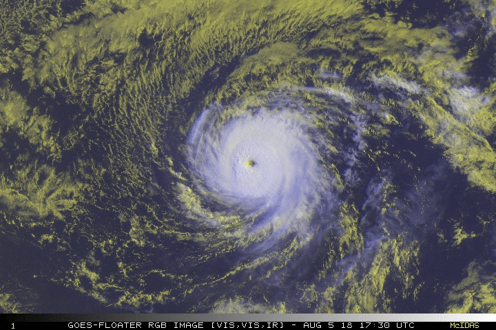
EP, 10, 2018080600, , BEST, 0, 145N, 1386W, 120, 947, HU
WPAC: HECTOR - Post-Tropical
Moderator: S2k Moderators
-
cycloneye

- Admin

- Posts: 149371
- Age: 69
- Joined: Thu Oct 10, 2002 10:54 am
- Location: San Juan, Puerto Rico
Re: EPAC: HECTOR - Hurricane
120 kts
0 likes
Visit the Caribbean-Central America Weather Thread where you can find at first post web cams,radars
and observations from Caribbean basin members Click Here
and observations from Caribbean basin members Click Here
-
Eric Webb
Re: EPAC: HECTOR - Hurricane
cycloneye wrote:120 ktsEP, 10, 2018080600, , BEST, 0, 145N, 1386W, 120, 947, HU
If this stands at the next advisory this should bring Hector to 16.87 ACE units
1 likes
-
xtyphooncyclonex

- Category 5

- Posts: 3891
- Age: 24
- Joined: Sat Dec 08, 2012 9:07 am
- Location: Cebu City
- Contact:
Re: EPAC: HECTOR - Hurricane
CrazyC83 wrote:That's a real breeding ground for intensification if Hector stays low and gets into that 30, 31C water closer to the dateline. That could EASILY support a strong cat 5.
I did hear about Hector losing latitude as it approaches (or after) the International Date Line. The resulting intensification could be unprecedented.
1 likes
REMINDER: My opinions that I, or any other NON Pro-Met in this forum, are unofficial. Please do not take my opinions as an official forecast and warning. I am NOT a meteorologist. Following my forecasts blindly may lead to false alarm, danger and risk if official forecasts from agencies are ignored.
-
Yellow Evan

- Professional-Met

- Posts: 16232
- Age: 27
- Joined: Fri Jul 15, 2011 12:48 pm
- Location: Henderson, Nevada/Honolulu, HI
- Contact:
Re: EPAC: HECTOR - Hurricane
xtyphooncyclonex wrote:CrazyC83 wrote:That's a real breeding ground for intensification if Hector stays low and gets into that 30, 31C water closer to the dateline. That could EASILY support a strong cat 5.
I did hear about Hector losing latitude as it approaches (or after) the International Date Line. The resulting intensification could be unprecedented.
I mean Ioke did the exact same thing.
1 likes


Re: EPAC: HECTOR - Hurricane
If my math is right, I got 16.7 units with latest 120kts
0 likes
The above post and any post by Ntxw is NOT an official forecast and should not be used as such. It is just the opinion of the poster and may or may not be backed by sound meteorological data. It is NOT endorsed by any professional institution including Storm2k. For official information, please refer to NWS products.
Help support Storm2K!

-
1900hurricane

- Category 5
- Posts: 6063
- Age: 34
- Joined: Fri Feb 06, 2015 12:04 pm
- Location: Houston, TX
- Contact:
Re: EPAC: HECTOR - Hurricane
I'm at 16.4925 units using best track.
0 likes
Contract Meteorologist. TAMU & MSST. Fiercely authentic, one of a kind. We are all given free will, so choose a life meant to be lived. We are the Masters of our own Stories.
Opinions expressed are mine alone.
Follow me on Twitter at @1900hurricane : Read blogs at https://1900hurricane.wordpress.com/
Opinions expressed are mine alone.
Follow me on Twitter at @1900hurricane : Read blogs at https://1900hurricane.wordpress.com/
-
Kingarabian

- S2K Supporter

- Posts: 16353
- Joined: Sat Aug 08, 2009 3:06 am
- Location: Honolulu, Hawaii
Re: EPAC: HECTOR - Hurricane
Kingarabian wrote:A few SSMIS passes will be in soon. Hope they don't miss the core.
Of course it missed
6 likes
RIP Kobe Bryant
-
xtyphooncyclonex
- Category 5
- Posts: 3891
- Age: 24
- Joined: Sat Dec 08, 2012 9:07 am
- Location: Cebu City
- Contact:
Re: EPAC: HECTOR - Hurricane
Yellow Evan wrote:xtyphooncyclonex wrote:CrazyC83 wrote:That's a real breeding ground for intensification if Hector stays low and gets into that 30, 31C water closer to the dateline. That could EASILY support a strong cat 5.
I did hear about Hector losing latitude as it approaches (or after) the International Date Line. The resulting intensification could be unprecedented.
I mean Ioke did the exact same thing.
But yeah, compared to Ioke---if it does, it would most likely be noticeably more powerful. This one could rack up more than 50 ACE units. I'm now going with mid-grade (145-155 kts) category 5 before the dateline, even more. Ioke only peaked at 140 kts. This hasn't even crossed the CPAC yet this has become powerful
1 likes
REMINDER: My opinions that I, or any other NON Pro-Met in this forum, are unofficial. Please do not take my opinions as an official forecast and warning. I am NOT a meteorologist. Following my forecasts blindly may lead to false alarm, danger and risk if official forecasts from agencies are ignored.
Re: EPAC: HECTOR - Hurricane
1900hurricane wrote:I'm at 16.4925 units using best track.
I got the same using BEST track. But a bit more with operational warnings.
http://rammb.cira.colostate.edu/products/tc_realtime/storm.asp?storm_identifier=EP102018
0 likes
The above post and any post by Ntxw is NOT an official forecast and should not be used as such. It is just the opinion of the poster and may or may not be backed by sound meteorological data. It is NOT endorsed by any professional institution including Storm2k. For official information, please refer to NWS products.
Help support Storm2K!
Help support Storm2K!
-
Eric Webb
Re: EPAC: HECTOR - Hurricane
Best track ACE is going to be a little lower than the official NHC advisories, I prefer to base the ACE calculations on the latter because BEST comes in usually an hr or two before the advisory comes out and there's still time for the TC to intensify and/or weaken in the mean time. I've also automated the ACE calculation to keep my sanity lol
3 likes
-
1900hurricane
- Category 5
- Posts: 6063
- Age: 34
- Joined: Fri Feb 06, 2015 12:04 pm
- Location: Houston, TX
- Contact:
Re: EPAC: HECTOR - Hurricane
Yeah, I can see why people like to use the public advisories, but there are still several reasons I prefer to use best track data aside from it just being easier. It's still official, even though it isn't released in public advisories, can be altered if needed (such as if recon finds the storm at a different intensity than expected), and also likes up very neatly with post season data, allowing direct comparisons with operational data.
1 likes
Contract Meteorologist. TAMU & MSST. Fiercely authentic, one of a kind. We are all given free will, so choose a life meant to be lived. We are the Masters of our own Stories.
Opinions expressed are mine alone.
Follow me on Twitter at @1900hurricane : Read blogs at https://1900hurricane.wordpress.com/
Opinions expressed are mine alone.
Follow me on Twitter at @1900hurricane : Read blogs at https://1900hurricane.wordpress.com/
Re: EPAC: HECTOR - Hurricane
4 likes
The above post and any post by Ntxw is NOT an official forecast and should not be used as such. It is just the opinion of the poster and may or may not be backed by sound meteorological data. It is NOT endorsed by any professional institution including Storm2k. For official information, please refer to NWS products.
Help support Storm2K!
Help support Storm2K!
-
Eric Webb
Re: EPAC: HECTOR - Hurricane
Just for a little perspective, Hector would need to maintain this intensity of 120 KT for about 11-12 days to beat Ioke's ACE record, if Hector sticks around for 2.5 weeks (or more) as the GFS and some EPS members are suggesting, Hector has plenty of time to cover a ton of ground.
1 likes
Re: EPAC: HECTOR - Hurricane
Kingarabian wrote:Kingarabian wrote:A few SSMIS passes will be in soon. Hope they don't miss the core.
Of course it missed
It's a MISSS pass.
Sorry.
5 likes
-
Yellow Evan
- Professional-Met
- Posts: 16232
- Age: 27
- Joined: Fri Jul 15, 2011 12:48 pm
- Location: Henderson, Nevada/Honolulu, HI
- Contact:
Re: EPAC: HECTOR - Hurricane
* EAST PACIFIC 2018 SHIPS INTENSITY FORECAST *
* IR SAT DATA AVAILABLE, OHC AVAILABLE *
* HECTOR EP102018 08/06/18 00 UTC *
TIME (HR) 0 6 12 18 24 36 48 60 72 84 96 108 120
V (KT) NO LAND 120 120 117 114 107 100 92 85 78 75 72 71 70
V (KT) LAND 120 120 117 114 107 100 92 85 78 75 72 71 70
V (KT) LGEM 120 118 113 108 103 96 92 88 85 84 85 87 91
Storm Type TROP TROP TROP TROP TROP TROP TROP TROP TROP TROP TROP TROP TROP
SHEAR (KT) 8 8 8 9 8 2 2 7 2 1 1 5 2
SHEAR ADJ (KT) -3 -4 -1 0 -1 0 2 2 0 1 0 -7 -6
SHEAR DIR 12 19 45 65 82 347 116 177 177 117 337 329 325
SST (C) 27.2 26.9 27.0 26.9 26.5 26.8 26.6 26.3 27.0 26.9 27.1 27.3 27.6
POT. INT. (KT) 137 134 135 134 130 134 132 128 136 134 136 138 141
200 MB T (C) -51.9 -52.1 -52.5 -52.4 -51.8 -52.2 -51.7 -52.0 -51.7 -51.9 -51.8 -52.1 -52.1
200 MB VXT (C) 0.5 0.8 1.1 1.0 1.0 1.2 1.1 1.2 1.2 1.3 1.2 1.0 0.8
TH_E DEV (C) 6 6 6 6 6 7 7 7 8 9 9 9 10
700-500 MB RH 50 53 53 50 49 45 42 40 37 35 35 37 40
MODEL VTX (KT) 23 23 21 22 20 21 20 21 20 20 21 21 21
850 MB ENV VOR 41 47 42 49 50 38 26 49 49 62 63 62 67
200 MB DIV -3 -22 -7 8 5 -16 27 18 30 -6 -12 -14 22
700-850 TADV -5 -2 -3 -6 -3 -7 -3 0 2 0 0 0 0
LAND (KM) 1809 1673 1537 1388 1239 922 601 355 248 407 552 701 921
LAT (DEG N) 14.5 14.8 15.0 15.4 15.7 16.2 16.6 16.8 16.7 16.8 17.3 17.6 17.8
LONG(DEG W) 138.6 139.9 141.1 142.5 143.8 146.8 150.0 153.0 156.0 158.9 161.7 164.6 167.4
STM SPEED (KT) 12 12 13 13 14 15 15 14 14 13 14 13 13
HEAT CONTENT 9 8 9 13 14 11 6 9 16 20 30 23 40
FORECAST TRACK FROM OFCI INITIAL HEADING/SPEED (DEG/KT):275/ 11 CX,CY: -10/ 1
T-12 MAX WIND: 110 PRESSURE OF STEERING LEVEL (MB): 563 (MEAN=584)
GOES IR BRIGHTNESS TEMP. STD DEV. 50-200 KM RAD: 5.1 (MEAN=14.5)
% GOES IR PIXELS WITH T < -20 C 50-200 KM RAD: 99.0 (MEAN=65.0)
PRELIM RI PROB (DV .GE. 55 KT IN 48 HR): 0.0
INDIVIDUAL CONTRIBUTIONS TO INTENSITY CHANGE
6 12 18 24 36 48 60 72 84 96 108 120
----------------------------------------------------------
SAMPLE MEAN CHANGE 0. 0. 1. 1. 1. 1. 1. 0. -1. -1. -2. -3.
SST POTENTIAL -2. -4. -7. -11. -19. -27. -36. -44. -50. -54. -57. -57.
VERTICAL SHEAR MAG -1. -3. -4. -4. -2. 1. 3. 7. 10. 12. 13. 13.
VERTICAL SHEAR ADJ 0. 0. 0. 0. 0. 0. 0. 0. 0. 0. 0. -1.
VERTICAL SHEAR DIR 0. 1. 1. 2. 3. 3. 2. 2. 2. 1. 0. 0.
PERSISTENCE 3. 4. 3. 3. 1. 0. -1. -1. -2. -3. -3. -3.
200/250 MB TEMP. 0. 0. 0. 0. 0. 0. 1. 3. 4. 4. 4. 4.
THETA_E EXCESS 0. 0. 0. 0. 0. 0. 1. 1. 2. 2. 3. 4.
700-500 MB RH 0. 0. 0. -1. -1. -2. -3. -4. -4. -5. -5. -6.
MODEL VTX TENDENCY 0. -1. 0. -3. -1. -3. -2. -4. -4. -3. -2. -3.
850 MB ENV VORTICITY 0. 0. 0. 0. 0. 0. 0. -1. -1. -1. -1. -1.
200 MB DIVERGENCE 0. -1. -1. -2. -2. -2. -2. -3. -3. -4. -4. -4.
850-700 T ADVEC 0. 0. 0. 0. 0. 0. 0. 0. 0. 0. 0. 0.
ZONAL STORM MOTION 0. 0. 1. 1. 1. 1. 1. 1. 1. 1. 1. 1.
STEERING LEVEL PRES 0. 0. 0. 0. 0. 0. 0. 0. 0. 0. 0. 0.
DAYS FROM CLIM. PEAK 0. 0. 0. 0. 0. 0. 0. 0. 1. 1. 1. 1.
GOES PREDICTORS 1. 2. 2. 3. 3. 3. 3. 2. 2. 2. 2. 2.
OCEAN HEAT CONTENT 0. 0. 0. 0. 0. 0. 0. 0. 0. 0. 0. 0.
RI POTENTIAL 0. 0. -1. -1. -2. -3. -3. -2. 0. 1. 2. 3.
----------------------------------------------------------
TOTAL CHANGE 0. -3. -6. -13. -19. -28. -35. -42. -45. -48. -49. -50.
CURRENT MAX WIND (KT): 120. LAT, LON: 14.5 138.6
** 2018 E. Pacific RI INDEX EP102018 HECTOR 08/06/18 00 UTC **
(SHIPS-RII PREDICTOR TABLE for 30 KT OR MORE MAXIMUM WIND INCREASE IN NEXT 24-h)
Predictor Value RI Predictor Range Scaled Value(0-1) % Contribution
POT = MPI-VMAX (KT) : 14.1 40.5 to 149.3 0.00 0.0
12 HR PERSISTENCE (KT) : 10.0 -22.0 to 44.0 0.48 999.0
850-200 MB SHEAR (KT) : 8.3 19.6 to 1.4 0.62 999.0
HEAT CONTENT (KJ/CM2) : 10.6 1.8 to 106.7 0.08 999.0
D200 (10**7s-1) : -3.8 -33.0 to 156.2 0.15 999.0
STD DEV OF IR BR TEMP : 5.1 37.8 to 2.1 0.92 999.0
MAXIMUM WIND (KT) : 120.0 22.5 to 132.0 0.16 999.0
BL DRY-AIR FLUX (W/M2) : 827.0 721.6 to -82.5 0.00 0.0
%area of TPW <45 mm upshear : 3.0 62.3 to 0.0 0.95 999.0
2nd PC OF IR BR TEMP : 0.4 2.2 to -1.9 0.43 999.0
SHIPS Prob RI for 20kt/ 12hr RI threshold= 0% is 0.0 times climatological mean ( 6.1%)
SHIPS Prob RI for 25kt/ 24hr RI threshold= 0% is 0.0 times climatological mean (12.5%)
SHIPS Prob RI for 30kt/ 24hr RI threshold= 0% is 0.0 times climatological mean ( 8.4%)
SHIPS Prob RI for 35kt/ 24hr RI threshold= 0% is 0.0 times climatological mean ( 6.0%)
SHIPS Prob RI for 40kt/ 24hr RI threshold= 0% is 0.0 times climatological mean ( 4.0%)
SHIPS Prob RI for 45kt/ 36hr RI threshold= 0% is 0.0 times climatological mean ( 6.5%)
SHIPS Prob RI for 55kt/ 48hr RI threshold= 0% is 0.0 times climatological mean ( 5.9%)
SHIPS Prob RI for 65kt/ 72hr RI threshold= 0% is 0.0 times climatological mean ( 4.8%)
Matrix of RI probabilities
------------------------------------------------------------------------------
RI (kt / h) | 20/12 | 25/24 | 30/24 | 35/24 | 40/24 | 45/36 | 55/48 |65/72
------------------------------------------------------------------------------
SHIPS-RII: 0.0% 0.0% 0.0% 0.0% 0.0% 0.0% 0.0% 0.0%
Logistic: 3.3% 1.3% 1.2% 0.9% 1.0% 0.5% 0.6% 0.0%
Bayesian: 0.0% 0.0% 0.0% 0.0% 0.0% 0.0% 0.0% 0.0%
Consensus: 1.1% 0.4% 0.4% 0.3% 0.3% 0.2% 0.2% 0.0%
DTOPS: 2.0% 1.0% 0.0% 0.0% 0.0% 0.0% 0.0% 0.0%
## ANNULAR HURRICANE INDEX (AHI) EP102018 HECTOR 08/06/18 00 UTC ##
## PASSED SCREENING STEP, MIGHT BE ANNULAR, CALCULATE AHI FROM DISCRIMINANT ANALYSIS ##
## AHI= 83 (AHI OF 100 IS BEST FIT TO ANN. STRUC., 1 IS MARGINAL, 0 IS NOT ANNULAR) ##
CONTRIBUTIONS TO ANNULAR INDEX
0 likes
-
1900hurricane
- Category 5
- Posts: 6063
- Age: 34
- Joined: Fri Feb 06, 2015 12:04 pm
- Location: Houston, TX
- Contact:
Re: EPAC: HECTOR - Hurricane
AHI = 83. Hmmm...
2 likes
Contract Meteorologist. TAMU & MSST. Fiercely authentic, one of a kind. We are all given free will, so choose a life meant to be lived. We are the Masters of our own Stories.
Opinions expressed are mine alone.
Follow me on Twitter at @1900hurricane : Read blogs at https://1900hurricane.wordpress.com/
Opinions expressed are mine alone.
Follow me on Twitter at @1900hurricane : Read blogs at https://1900hurricane.wordpress.com/
-
Kingarabian
- S2K Supporter
- Posts: 16353
- Joined: Sat Aug 08, 2009 3:06 am
- Location: Honolulu, Hawaii
Re: EPAC: HECTOR - Hurricane
Visioen wrote:Kingarabian wrote:Kingarabian wrote:A few SSMIS passes will be in soon. Hope they don't miss the core.
Of course it missed
It's a MISSS pass.
Sorry.
Lmao. That's painfully fitting.
4 likes
RIP Kobe Bryant
-
SEASON_CANCELED

- Category 3

- Posts: 887
- Joined: Mon Jul 06, 2009 5:17 am
- Location: 8 Bit Charlie Sheen
Re: EPAC: HECTOR - Hurricane
media is way overhyping this one. These storms get shredded up before they get close to the big island. Its very rare they make it, they have to be moving fast
1 likes
i am a big stupid ugly moron with an ugly face and a big butt and my butt stinks and i like to kiss my own butt

Re: EPAC: HECTOR - Hurricane
SEASON_CANCELED wrote:media is way overhyping this one. These storms get shredded up before they get close to the big island. Its very rare they make it, they have to be moving fast
They may be overhyping its threat to Hawaii but not its intensity. It's likely that this could pass by as a major hurricane.
5 likes
Igor 2010, Sandy 2012, Fay 2014, Gonzalo 2014, Joaquin 2015, Nicole 2016, Humberto 2019, Imelda 2025
I am only a tropical weather enthusiast. My predictions are not official and may or may not be backed by sound meteorological data. For official information, please refer to the NHC and NWS products.
I am only a tropical weather enthusiast. My predictions are not official and may or may not be backed by sound meteorological data. For official information, please refer to the NHC and NWS products.

Re: EPAC: HECTOR - Hurricane
CrazyC83 wrote:With the new data, I would estimate the intensity at 130 kt. The T6.7 estimate seems fairly reasonable.
Yes, 130 knots from me as well.
CrazyC83 wrote:That's a real breeding ground for intensification if Hector stays low and gets into that 30, 31C water closer to the dateline. That could EASILY support a strong cat 5.
xtyphooncyclonex wrote:I did hear about Hector losing latitude as it approaches (or after) the International Date Line. The resulting intensification could be unprecedented.
That's the dream! The more low he stays, the more interesting this gets. For heaven's sake Hector, lose some latitude!
1900hurricane wrote:AHI = 83. Hmmm...
When I saw the SHIPS output I scrolled right to the AHI and had the same reaction.
1 likes
Who is online
Users browsing this forum: No registered users and 22 guests