

CPAC: LANE - Post-Tropical
Moderator: S2k Moderators
Re: CPAC: LANE - Hurricane
Actually looks like the west side is recovering from the shear cold cloud top building back up in the last few frames
1 likes
-
SconnieCane
- Category 5

- Posts: 1013
- Joined: Thu Aug 02, 2018 5:29 pm
- Location: Madison, WI
Re: CPAC: LANE - Hurricane
It took Lane traveling five degrees of longitude to gain one degree of latitude. The right hook needs to start likely within the next couple of hours for a Hawaii impact. Not that this would be a bad thing if it just kept moving WNW, but that's not what the models have been showing.
1 likes
-
boulderrr
- Tropical Depression

- Posts: 55
- Joined: Mon Aug 22, 2016 11:30 am
- Location: Nederland, Colorado - 8,500'
Re: CPAC: LANE - Hurricane
12Z GFS is quite a bit west so far.
Edit: It still has the northeastward bend at 48-54 hours, bringing it very close to Maui.
Edit: It still has the northeastward bend at 48-54 hours, bringing it very close to Maui.
0 likes
-
Kingarabian

- S2K Supporter

- Posts: 16367
- Joined: Sat Aug 08, 2009 3:06 am
- Location: Honolulu, Hawaii
Re: CPAC: LANE - Hurricane
12Z GFS into Maui again.
CPHC forecast track barely has Maui in the cone...
CPHC forecast track barely has Maui in the cone...
0 likes
RIP Kobe Bryant
-
Kingarabian
- S2K Supporter
- Posts: 16367
- Joined: Sat Aug 08, 2009 3:06 am
- Location: Honolulu, Hawaii


-
Kingarabian
- S2K Supporter
- Posts: 16367
- Joined: Sat Aug 08, 2009 3:06 am
- Location: Honolulu, Hawaii
Re: CPAC: LANE - Hurricane
Kingarabian wrote:Anyone have ther 12z UKMET?
The 12Z UKMET should be out within 20 minutes.
0 likes
Personal Forecast Disclaimer:
The posts in this forum are NOT official forecast and should not be used as such. They are just the opinion of the poster and may or may not be backed by sound meteorological data. They are NOT endorsed by any professional institution or storm2k.org. For official information, please refer to RSMC and NWS products.
The posts in this forum are NOT official forecast and should not be used as such. They are just the opinion of the poster and may or may not be backed by sound meteorological data. They are NOT endorsed by any professional institution or storm2k.org. For official information, please refer to RSMC and NWS products.


Re: CPAC: LANE - Hurricane
1 likes
The above post and any post by Ntxw is NOT an official forecast and should not be used as such. It is just the opinion of the poster and may or may not be backed by sound meteorological data. It is NOT endorsed by any professional institution including Storm2k. For official information, please refer to NWS products.
Help support Storm2K!

Re: CPAC: LANE - Hurricane
WTNT82 EGRR 221605
MET OFFICE TROPICAL CYCLONE GUIDANCE FOR NORTH-EAST PACIFIC AND ATLANTIC
GLOBAL MODEL DATA TIME 1200UTC 22.08.2018
HURRICANE LANE ANALYSED POSITION : 15.0N 155.0W
ATCF IDENTIFIER : EP142018
LEAD CENTRAL MAXIMUM WIND
VERIFYING TIME TIME POSITION PRESSURE (MB) SPEED (KNOTS)
-------------- ---- -------- ------------- -------------
1200UTC 22.08.2018 0 15.0N 155.0W 974 66
0000UTC 23.08.2018 12 15.9N 156.4W 967 71
1200UTC 23.08.2018 24 17.1N 157.1W 966 68
0000UTC 24.08.2018 36 18.4N 157.1W 971 65
1200UTC 24.08.2018 48 20.0N 156.8W 994 61
0000UTC 25.08.2018 60 20.6N 158.2W 1004 38
1200UTC 25.08.2018 72 20.1N 159.2W 1005 33
0000UTC 26.08.2018 84 20.2N 160.5W 1006 31
1200UTC 26.08.2018 96 19.9N 162.0W 1007 27
0000UTC 27.08.2018 108 20.3N 163.4W 1006 25
1200UTC 27.08.2018 120 20.6N 164.0W 1005 30
0000UTC 28.08.2018 132 20.9N 164.5W 1004 32
1200UTC 28.08.2018 144 21.3N 165.0W 1004 29
0 likes


-
Aric Dunn
- Category 5
- Posts: 21238
- Age: 43
- Joined: Sun Sep 19, 2004 9:58 pm
- Location: Ready for the Chase.
- Contact:
Re: CPAC: LANE - Hurricane
eyewall slowly starting to come into radar range..
0 likes
Note: If I make a post that is brief. Please refer back to previous posts for the analysis or reasoning. I do not re-write/qoute what my initial post said each time.
If there is nothing before... then just ask
Space & Atmospheric Physicist, Embry-Riddle Aeronautical University,
I believe the sky is falling...
If there is nothing before... then just ask
Space & Atmospheric Physicist, Embry-Riddle Aeronautical University,
I believe the sky is falling...
-
wxman57

- Moderator-Pro Met

- Posts: 23175
- Age: 68
- Joined: Sat Jun 21, 2003 8:06 pm
- Location: Houston, TX (southwest)
Re: CPAC: LANE - Hurricane
Good video discussion from Levi at Tropical Tidbits this morning:
https://www.tropicaltidbits.com/blog/2018/08/22/wednesday-morning-dangerous-hurricane-lane-approaching-hawaii-hurricane-warnings-and-watches-issued/
I still don't buy the GFS solution. A track about 100 miles west of the Big Island and 80 miles or so SW of Honolulu looks reasonable. This puts the islands in low-end TS winds for the most part, as hurricane force winds only extend out 30-40 miles from the center (at most). Bigger problem for the islands will be prolonged heavy rain as the center parallels the islands on Thu/Fri. Could be over 2 ft of rain on south and eastern slopes of the mountains, all draining down to the coast. Oahu could be hard hit by heavy rain in the mountains north of Mamala Bay (Honolulu area). On the current forecast track, though, Honolulu would see sustained winds in the 35-45 mph range with higher gusts.
0 likes
Re: CPAC: LANE - Hurricane
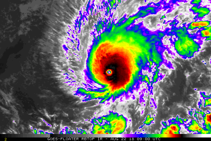
Looks like it's re-intensifying as per latest satellite imagery.
0 likes
Personal Forecast Disclaimer:
The posts in this forum are NOT official forecast and should not be used as such. They are just the opinion of the poster and may or may not be backed by sound meteorological data. They are NOT endorsed by any professional institution or storm2k.org. For official information, please refer to RSMC and NWS products.
The posts in this forum are NOT official forecast and should not be used as such. They are just the opinion of the poster and may or may not be backed by sound meteorological data. They are NOT endorsed by any professional institution or storm2k.org. For official information, please refer to RSMC and NWS products.
Re: CPAC: LANE - Hurricane
NotoSans wrote:Looks like it's re-intensifying as per latest satellite imagery.
Lane has been defying shear forecasts once he passed 150W
0 likes
The above post and any post by Ntxw is NOT an official forecast and should not be used as such. It is just the opinion of the poster and may or may not be backed by sound meteorological data. It is NOT endorsed by any professional institution including Storm2k. For official information, please refer to NWS products.
Help support Storm2K!
Help support Storm2K!
-
SunnyThoughts
- Category 5
- Posts: 2263
- Joined: Wed Jul 09, 2003 12:42 pm
- Location: Pensacola, Florida
Re: CPAC: LANE - Hurricane
My goodness, just when you think the shear is going to weaken the storm, it seems to fight it off and intensify yet again.
0 likes
-
1900hurricane

- Category 5
- Posts: 6063
- Age: 34
- Joined: Fri Feb 06, 2015 12:04 pm
- Location: Houston, TX
- Contact:
Re: CPAC: LANE - Hurricane
DT up to 7.0.

1 likes
Contract Meteorologist. TAMU & MSST. Fiercely authentic, one of a kind. We are all given free will, so choose a life meant to be lived. We are the Masters of our own Stories.
Opinions expressed are mine alone.
Follow me on Twitter at @1900hurricane : Read blogs at https://1900hurricane.wordpress.com/
Opinions expressed are mine alone.
Follow me on Twitter at @1900hurricane : Read blogs at https://1900hurricane.wordpress.com/
-
TheAustinMan

- Category 5
- Posts: 1060
- Joined: Mon Jul 08, 2013 4:26 pm
- Location: Central TX / United States
Re: CPAC: LANE - Hurricane
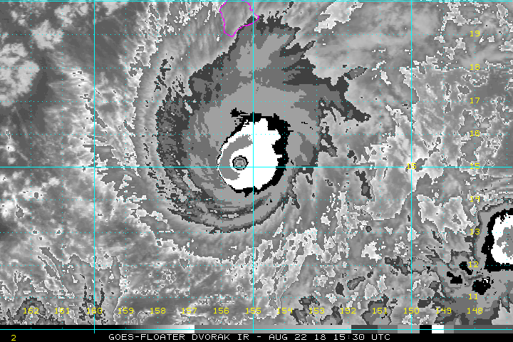
First morning visible shows the extensive cirrus outflow to the north and the well-defined eye.
1 MB. Source: https://weather.msfc.nasa.gov/GOES/

1 MB. Source: https://weather.msfc.nasa.gov/GOES/
0 likes
Treat my opinions with a grain of salt. For official information see your local weather service.
“It's tough to make predictions, especially about the future.”
“It's tough to make predictions, especially about the future.”
Re: CPAC: LANE - Hurricane
Do we have a plane going in? It is probably a Cat 5 again.
1 likes
The above post and any post by Ntxw is NOT an official forecast and should not be used as such. It is just the opinion of the poster and may or may not be backed by sound meteorological data. It is NOT endorsed by any professional institution including Storm2k. For official information, please refer to NWS products.
Help support Storm2K!
Help support Storm2K!
Who is online
Users browsing this forum: No registered users and 35 guests