What the Euro is showing day 10 in the Bahamas is already marked by the NHC and being discussed in this thread:
viewtopic.php?f=31&t=119772
2018 Tropics: Global Model Runs Discussion (Out to day 16)
Moderator: S2k Moderators
Forum rules

The posts in this forum are NOT official forecasts and should not be used as such. They are just the opinion of the poster and may or may not be backed by sound meteorological data. They are NOT endorsed by any professional institution or STORM2K. For official information, please refer to products from the National Hurricane Center and National Weather Service.

Re: 2018 Tropics: Global Model Runs Discussion (Out to day 16)
GFS trending towards less instability over the last several runs with the waves also continuing to trend further north and east.
0 likes
The above post is not official and should not be used as such. It is the opinion of the poster and may or may not be backed by sound meteorological data. It is not endorsed by any professional institution or storm2k.org. For official information, please refer to the NHC and NWS products.

Re: 2018 Tropics: Global Model Runs Discussion (Out to day 16)
Hammy wrote:GFS trending towards less instability over the last several runs with the waves also continuing to trend further north and east.
I have noticed the same thing today the GFS is pulling back even in the ensembles. However the Euro is even more bullish with the development in 10-15 day range. Let's see who is right. I would put my bet on the Euro.

0 likes
The following post is NOT an official forecast and should not be used as such. It is just the opinion of the poster and may or may not be backed by sound meteorological data. It is NOT endorsed by any professional institution including storm2k.org For Official Information please refer to the NHC and NWS products.
-
wxGuy
Re: 2018 Tropics: Global Model Runs Discussion (Out to day 16)
wxGuy wrote:GFS showing 05' like path similar to Katrina, Rita watch the looop


from yesterday
0 likes
Re: 2018 Tropics: Global Model Runs Discussion (Out to day 16)
LarryWx wrote:LarryWx wrote:gatorcane wrote:12Z ECMWF with a strong area of low pressure near the Cabo Verde islands at 240 hours:
Consistent with the 12Z Euro operational, about 20% of the 50 EPS (~10) members have a TC form in the far E MDR ~Sept. 1 moving W to WNW. 4 of those 10 geneses go down to sub 990 mb (i.e., likely hurricanes). By day 15 (9/5), the TCs are mainly between 40W and 50W with some safely recurving N of 20N while others are still between 15N and 20N moving mainly WNW. None of these were on the 0Z EPS.
The above referenced more active 12Z EPS had gotten my and others’ attention and got Maue and Ventrice to tweet. However, today’s 0Z EPS then had significantly less activity regarding the potential Sept. 1 far E MDR system than what yesterday’s 12Z EPS had. Let’s see what today’s 12Z Euro/EPS shows.
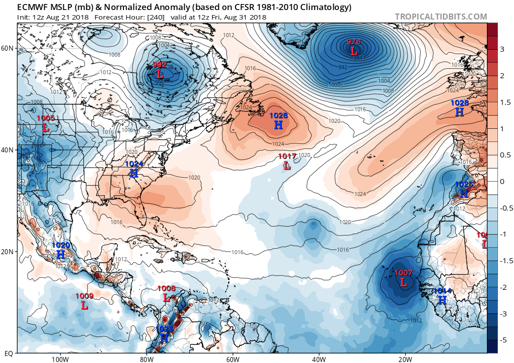
Potential far E MDR Sept. 1 system EPS update:
Today's 12Z EPS, though a bit more active than the 0Z, is not quite as active as yesterday's 12Z EPS when considering intensity/size. Nevertheless, I still found near 10 TC's/4 H's out of ~50 members. All 4 H's recurve east of 45W, however. So, at this point, the run suggests no more than minimal threat to the western basin. Oncoming El Nino seasons have had higher rates of safe recurvature of E MDR systems than non-El Nino seasons. But it is very early and the situation could easily change to more threatening though hopefully it won't.
3 likes
Personal Forecast Disclaimer:
The posts in this forum are NOT official forecasts and should not be used as such. They are just the opinion of the poster and may or may not be backed by sound meteorological data. They are NOT endorsed by any professional institution or storm2k.org. For official information, please refer to the NHC and NWS products.
The posts in this forum are NOT official forecasts and should not be used as such. They are just the opinion of the poster and may or may not be backed by sound meteorological data. They are NOT endorsed by any professional institution or storm2k.org. For official information, please refer to the NHC and NWS products.
-
stormlover2013
Re: 2018 Tropics: Global Model Runs Discussion (Out to day 16)
Ridge looks strong...I don’t see a curved
0 likes
Re: 2018 Tropics: Global Model Runs Discussion (Out to day 16)
GFS back to showing zilch through 288 hours, not even any sort of definable low pressure. The phantom storms have even been pushed back to the end of the run yet again.
0 likes
The above post is not official and should not be used as such. It is the opinion of the poster and may or may not be backed by sound meteorological data. It is not endorsed by any professional institution or storm2k.org. For official information, please refer to the NHC and NWS products.
-
Hurricaneman

- Category 5

- Posts: 7404
- Age: 45
- Joined: Tue Aug 31, 2004 3:24 pm
- Location: central florida
Re: 2018 Tropics: Global Model Runs Discussion (Out to day 16)
Hammy wrote:GFS back to showing zilch through 288 hours, not even any sort of definable low pressure. The phantom storms have even been pushed back to the end of the run yet again.
Maybe a case where the GFS could be wrong as it develops nothing within 10days while it seems the Euro does or tries to
0 likes
-
TheStormExpert
Re: 2018 Tropics: Global Model Runs Discussion (Out to day 16)
This is starting to sound just like 2013 again. Only this time most are actually expecting a overall dead season for the Atlantic.
0 likes
Re: 2018 Tropics: Global Model Runs Discussion (Out to day 16)
TheStormExpert wrote:This is starting to sound just like 2013 again. Only this time most are actually expecting a overall dead season for the Atlantic.
2013 at least had some phantom hurricanes to watch
I will say I basically expected this season to be heavily MJO-dependent similar to 2014, but wasn't expecting the pattern to stick in one place like it has which has really put a damper on August activity especially in the deep tropics.
Edit: CFS pushed development back yet again, was originally showing Aug 15th, then 22nd for a few days, then Aug 28 for about the last week, and now it's showing nothing at all before about Sep 4.
0 likes
The above post is not official and should not be used as such. It is the opinion of the poster and may or may not be backed by sound meteorological data. It is not endorsed by any professional institution or storm2k.org. For official information, please refer to the NHC and NWS products.
-
Sciencerocks
- Category 5
- Posts: 10181
- Age: 40
- Joined: Thu Jul 06, 2017 1:51 am
Re: 2018 Tropics: Global Model Runs Discussion (Out to day 16)
Outside of the subtropics I wouldn't expect any development for the next two weeks.
The dry air cap should kill everything in the mdr and the tropics.
The dry air cap should kill everything in the mdr and the tropics.
1 likes
 hmmmmm
-
wxGuy
Re: 2018 Tropics: Global Model Runs Discussion (Out to day 16)
3 days in a row showing something coming in Gulf, and hitting coast
1 likes
-
cycloneye

- Admin

- Posts: 149342
- Age: 69
- Joined: Thu Oct 10, 2002 10:54 am
- Location: San Juan, Puerto Rico
Re: 2018 Tropics: Global Model Runs Discussion (Out to day 16)
@EricBlake12
Lots of models now showing the quiet August in the Atlantic reversing into a more active September- keep watching the Tropics as we have a long way to go in the 2018 #hurricane season.
https://twitter.com/EricBlake12/status/1032602549352841216
Lots of models now showing the quiet August in the Atlantic reversing into a more active September- keep watching the Tropics as we have a long way to go in the 2018 #hurricane season.
https://twitter.com/EricBlake12/status/1032602549352841216
1 likes
Visit the Caribbean-Central America Weather Thread where you can find at first post web cams,radars
and observations from Caribbean basin members Click Here
and observations from Caribbean basin members Click Here
2018 Tropics: Global Model Runs Discussion (Out to day 16)
Euro looks weaker on 12z vs 0z with both the end of run low off Africa and the Straits wave.
0 likes
The above post is not official and should not be used as such. It is the opinion of the poster and may or may not be backed by sound meteorological data. It is not endorsed by any professional institution or storm2k.org. For official information, please refer to the NHC and NWS products.
-
stormlover2013
Re: 2018 Tropics: Global Model Runs Discussion (Out to day 16)
looks the same to me but the ridge is stout
0 likes
-
gatorcane

- S2K Supporter

- Posts: 23708
- Age: 48
- Joined: Sun Mar 13, 2005 3:54 pm
- Location: Boca Raton, FL
Re: 2018 Tropics: Global Model Runs Discussion (Out to day 16)
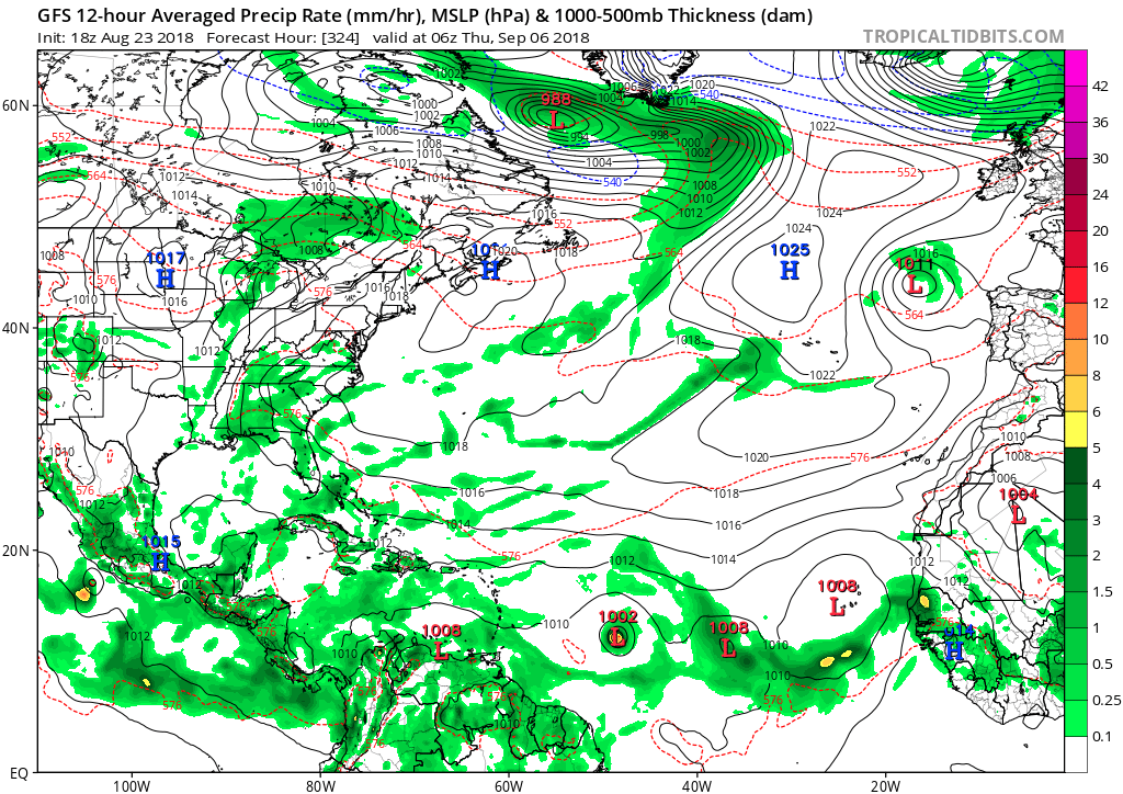
active MDR as shown on GFS on long-range:
1 likes

Re: 2018 Tropics: Global Model Runs Discussion (Out to day 16)
GFS is starting to sniff the anticipated better environment coming up for the Atlantic Basin.

0 likes
Re: 2018 Tropics: Global Model Runs Discussion (Out to day 16)
0 likes
The above post is not official and should not be used as such. It is the opinion of the poster and may or may not be backed by sound meteorological data. It is not endorsed by any professional institution or storm2k.org. For official information, please refer to the NHC and NWS products.
-
Hurricaneman
- Category 5
- Posts: 7404
- Age: 45
- Joined: Tue Aug 31, 2004 3:24 pm
- Location: central florida
Re: 2018 Tropics: Global Model Runs Discussion (Out to day 16)
Based on the models it wouldn’t surprise me to.see a burst of 5 named storms within a 15 day period as the models lower pressures and dump the low instability for a moisture rich environment
2 likes
Who is online
Users browsing this forum: No registered users and 62 guests