I wouldn’t be so quick to write this off in the Gulf. First off the 12z Euro once again sends it quickly into the SE Louisiana coast right as it gets going, it also looks to keep a well-defined signature as it heads west inland towards SE Texas. Secondly the Instability in the Gulf has been above average since the beginning of May. Then there is the warm mid-upper 80’s bath water (SST’s) that are currently present. So that leaves limited time over water and wind shear as the two possible inhibitors.
https://twitter.com/stuostro/status/1034827423244857344
Tropical Wave over the SE Bahamas (Is INVEST 91L)
Moderator: S2k Moderators
Forum rules

The posts in this forum are NOT official forecasts and should not be used as such. They are just the opinion of the poster and may or may not be backed by sound meteorological data. They are NOT endorsed by any professional institution or STORM2K. For official information, please refer to products from the National Hurricane Center and National Weather Service.
-
stormlover2013
Re: Tropical Wave Axis Across Leeward Islands
Sambucol wrote:Cpv17 wrote:stormlover2013 wrote:CP17 where u from
SE TX. Looking like lots of rain coming for my area over the next week or two.
Same here in SETX. Harveyland.
Same here we all from SETX lol
1 likes
-
stormlover2013
Re: Tropical Wave Axis Across Leeward Islands
LarryWx wrote:The 12Z EPS has many fewer sub 999 mb TCs among its 51 members: only 4 vs 11 on the 0Z EPS. So, an overall bearish Euro suite trend at 12Z fwiw.
post image
0 likes
-
jlauderdal
- S2K Supporter

- Posts: 7240
- Joined: Wed May 19, 2004 5:46 am
- Location: NE Fort Lauderdale
- Contact:
Re: Tropical Wave Axis Across Leeward Islands
been wet all week, rains every 6-8 hours with showers and tstorms coming in from the ATL
0 likes
-
tarheelprogrammer

- S2K Supporter
- Posts: 1793
- Joined: Mon Mar 28, 2016 9:25 pm
- Location: Raleigh, NC area (Garner, NC)
Re: Tropical Wave Axis Across Leeward Islands
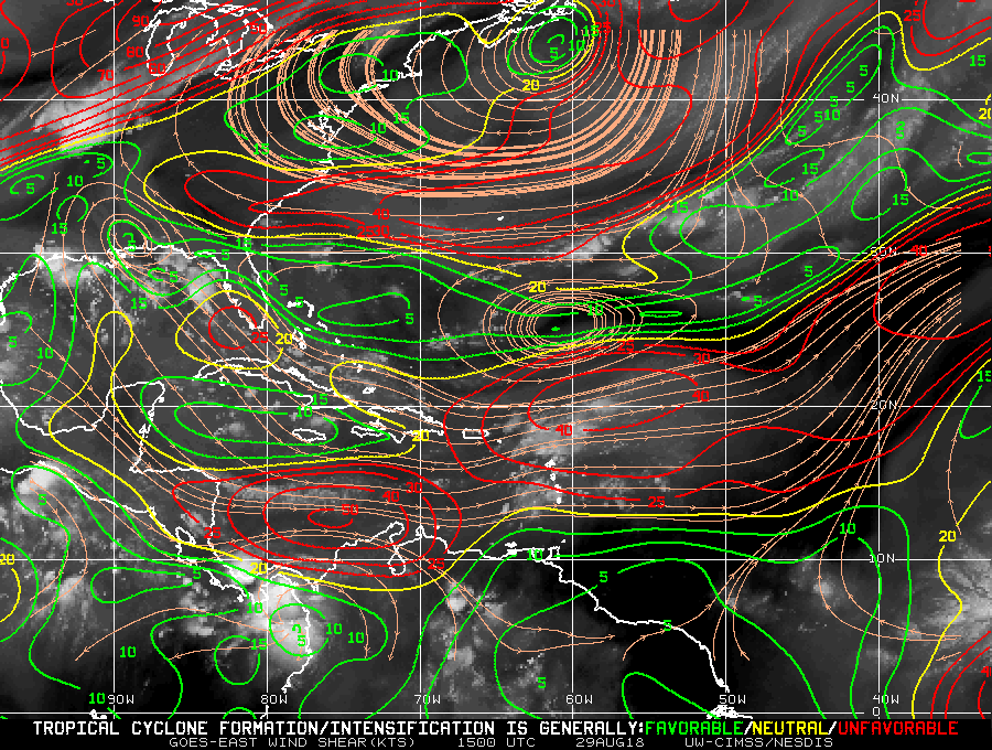
TheStormExpert wrote:I wouldn’t be so quick to write this off in the Gulf. First off the 12z Euro once again sends it quickly into the SE Louisiana coast right as it gets going, it also looks to keep a well-defined signature as it heads west inland towards SE Texas. Secondly the Instability in the Gulf has been above average since the beginning of May. Then there is the warm mid-upper 80’s bath water (SST’s) that are currently present. So that leaves limited time over water and wind shear as the two possible inhibitors.
https://twitter.com/stuostro/status/1034827423244857344
In terms of negatives Wind Shear is the top dog though. Without favorable shear environments these systems struggle to get going. It is what tears apart storms. June in the GOM the past decade is a good example of this. All the warmest waters and instability in the world cannot overcome shear issues. It is still 5 days away so shear forecasts could be off by quite a bit I am sure, but if shear is high this system will struggle to get to TS strength. IMHO.
2 likes
My posts are not official forecasts. They are just my opinion and may or may not be backed by sound meteorological data. They are NOT endorsed by any professional institution or storm2k.org. For official information, please refer to the NHC and NWS products.
-
TheStormExpert
Re: Tropical Wave Axis Across Leeward Islands
jlauderdal wrote:been wet all week, rains every 6-8 hours with showers and tstorms coming in from the ATLSFLcane wrote:It could get quite rainy across South Florida...
https://www.imageupload.co.uk/images/2018/08/29/wow.png
Yes the last several days have been more unstable than usual across coastal Palm Beach County at least. Though overall since early-mid June it’s been more on the drier side of things. We could use the rain again after the May deluge as the ponds and lawn are slowly drying up some.
0 likes
-
TheStormExpert
Re: Tropical Wave Axis Across Leeward Islands
tarheelprogrammer wrote:TheStormExpert wrote:I wouldn’t be so quick to write this off in the Gulf. First off the 12z Euro once again sends it quickly into the SE Louisiana coast right as it gets going, it also looks to keep a well-defined signature as it heads west inland towards SE Texas. Secondly the Instability in the Gulf has been above average since the beginning of May. Then there is the warm mid-upper 80’s bath water (SST’s) that are currently present. So that leaves limited time over water and wind shear as the two possible inhibitors.
https://twitter.com/stuostro/status/1034827423244857344
In terms of negatives Wind Shear is the top dog though. Without favorable shear environments these systems struggle to get going. It is what tears apart storms. June in the GOM the past decade is a good example of this. All the warmest waters and instability in the world cannot overcome shear issues. It is still 5 days away so shear forecasts could be off by quite a bit I am sure, but if shear is high this system will struggle to get to TS strength. IMHO.
Overall wind shear has been below normal in the Gulf as of recent.

3 likes
-
TheStormExpert
Re: Tropical Wave Axis Across Leeward Islands
stormlover2013 wrote:LarryWx wrote:The 12Z EPS has many fewer sub 999 mb TCs among its 51 members: only 4 vs 11 on the 0Z EPS. So, an overall bearish Euro suite trend at 12Z fwiw.
post image

3 likes
-
jlauderdal
- S2K Supporter
- Posts: 7240
- Joined: Wed May 19, 2004 5:46 am
- Location: NE Fort Lauderdale
- Contact:
Re: Tropical Wave Axis Across Leeward Islands
we have another round inbound now, had a round this morning and last night..feels more like june than august
0 likes


Re: Tropical Wave Axis Across Leeward Islands
tarheelprogrammer wrote:TheStormExpert wrote:I wouldn’t be so quick to write this off in the Gulf. First off the 12z Euro once again sends it quickly into the SE Louisiana coast right as it gets going, it also looks to keep a well-defined signature as it heads west inland towards SE Texas. Secondly the Instability in the Gulf has been above average since the beginning of May. Then there is the warm mid-upper 80’s bath water (SST’s) that are currently present. So that leaves limited time over water and wind shear as the two possible inhibitors.
In terms of negatives Wind Shear is the top dog though. Without favorable shear environments these systems struggle to get going. It is what tears apart storms. June in the GOM the past decade is a good example of this. All the warmest waters and instability in the world cannot overcome shear issues. It is still 5 days away so shear forecasts could be off by quite a bit I am sure, but if shear is high this system will struggle to get to TS strength. IMHO.
Cue the shear map! Shear, for now, is favorable in most of the GoM, though we all know how quickly that can change. Like I said earlier, I've been watching it for a while now, and it's moved all over the place, and quickly too.
1 likes
Personal Forecast Disclaimer:
The posts in this forum are NOT official forecast and should not be used as such. They are just the opinion of the poster and may or may not be backed by sound meteorological data. They are NOT endorsed by any professional institution or storm2k.org. For official information, please refer to the NHC and NWS products.
The posts in this forum are NOT official forecast and should not be used as such. They are just the opinion of the poster and may or may not be backed by sound meteorological data. They are NOT endorsed by any professional institution or storm2k.org. For official information, please refer to the NHC and NWS products.
-
Wakeknight
- Tropical Low

- Posts: 26
- Joined: Fri Sep 02, 2016 7:37 am
- Location: Nokomis, FL
Re: Tropical Wave Axis Across Leeward Islands
jlauderdal wrote:we have another round inbound now, had a round this morning and last night..feels more like june than augustTheStormExpert wrote:jlauderdal wrote:been wet all week, rains every 6-8 hours with showers and tstorms coming in from the ATL
Yes the last several days have been more unstable than usual across coastal Palm Beach County at least. Though overall since early-mid June it’s been more on the drier side of things. We could use the rain again after the May deluge as the ponds and lawn are slowly drying up some.
Here in Sarasota we have had a dry summer; our normal afternoon summer storm pattern settled in much later that usual.
0 likes
Re: Tropical Wave Axis Across Leeward Islands
TheStormExpert wrote:stormlover2013 wrote:LarryWx wrote:The 12Z EPS has many fewer sub 999 mb TCs among its 51 members: only 4 vs 11 on the 0Z EPS. So, an overall bearish Euro suite trend at 12Z fwiw.
http://i67.tinypic.com/drfo76.jpg
Thanks for posting. For those who may be confused, this image shows that there are far fewer TS+s (blue/orange) on this 12Z EPS vs the 0Z EPS. Note that the vast majority of the ones on this image are only green/TD strength. Note that this 12Z does have one H (into TX), a cat 2. Neither the 0Z nor any earlier run had any cat 2+.
Last edited by LarryWx on Wed Aug 29, 2018 4:05 pm, edited 5 times in total.
0 likes
Personal Forecast Disclaimer:
The posts in this forum are NOT official forecasts and should not be used as such. They are just the opinion of the poster and may or may not be backed by sound meteorological data. They are NOT endorsed by any professional institution or storm2k.org. For official information, please refer to the NHC and NWS products.
The posts in this forum are NOT official forecasts and should not be used as such. They are just the opinion of the poster and may or may not be backed by sound meteorological data. They are NOT endorsed by any professional institution or storm2k.org. For official information, please refer to the NHC and NWS products.
-
stormlover2013
Re: Tropical Wave Axis Across Leeward Islands
if anything scoots all the away across the GOM mark it down it will be stronger than a trop storm
2 likes

Re: Tropical Wave Axis Across Leeward Islands
stormlover2013 wrote:if anything scoots all the away across the GOM mark it down it will be stronger than a trop storm
Depends on shear.
3 likes
-
cycloneye

- Admin

- Posts: 149377
- Age: 69
- Joined: Thu Oct 10, 2002 10:54 am
- Location: San Juan, Puerto Rico
Re: Tropical Wave Axis Across Leeward Islands
18z surface analysis. Wave moving more slowly as axis is still in Leewards.

0 likes
Visit the Caribbean-Central America Weather Thread where you can find at first post web cams,radars
and observations from Caribbean basin members Click Here
and observations from Caribbean basin members Click Here
-
jlauderdal
- S2K Supporter
- Posts: 7240
- Joined: Wed May 19, 2004 5:46 am
- Location: NE Fort Lauderdale
- Contact:
Re: Tropical Wave Axis Across Leeward Islands
if it scoots it wont have time to develop into a cane..stormlover2013 wrote:if anything scoots all the away across the GOM mark it down it will be stronger than a trop storm
0 likes
-
stormlover2013
-
MGC

- S2K Supporter
- Posts: 5940
- Joined: Sun Mar 23, 2003 9:05 pm
- Location: Pass Christian MS, or what is left.
Re: Tropical Wave Axis Across Leeward Islands
This time of year all potential disturbances must be closely monitored. Things can spin up in the gulf quickly.....MGC
1 likes

Re: Tropical Wave Axis Across Leeward Islands
GFS seems like it's been trending stronger today.
0 likes
The above post is not official and should not be used as such. It is the opinion of the poster and may or may not be backed by sound meteorological data. It is not endorsed by any professional institution or storm2k.org. For official information, please refer to the NHC and NWS products.
Re: Tropical Wave Axis Across Leeward Islands
18z GFS has the max vorticity going into the San Antonio Bay area late next week. This would bring a lot of rain to SETX and probably Louisiana as well.

1 likes
Who is online
Users browsing this forum: JoshwaDone and 112 guests