1900hurricane wrote:Recent ATMS and F-15 passes don't seem to indicate any hint of eyewall replacement.
for other posters that want to see it:

from the latest multi-sensor pass on Florence @ https://www.nrlmry.navy.mil/TC.html
Moderator: S2k Moderators
1900hurricane wrote:Recent ATMS and F-15 passes don't seem to indicate any hint of eyewall replacement.

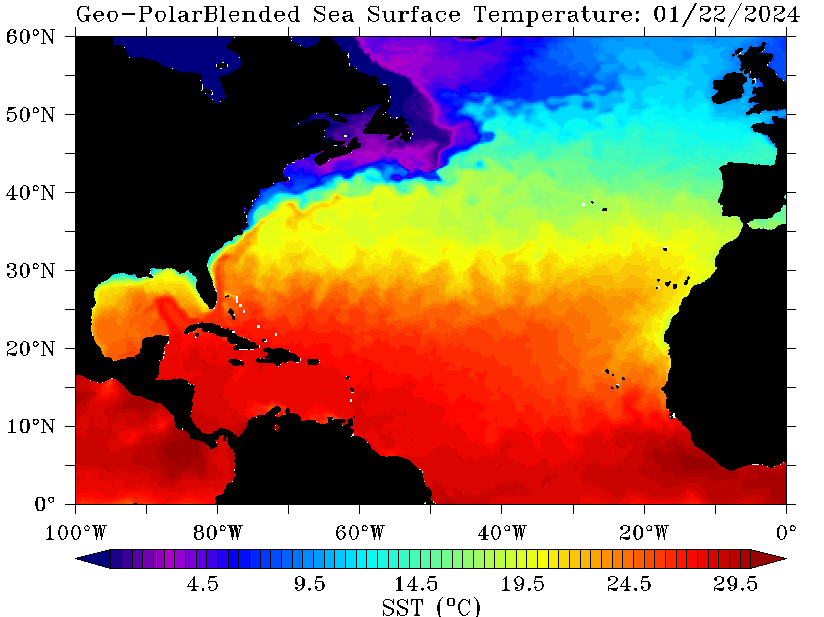
EquusStorm wrote:Is the oceanic heat content here sufficient to have a brief Cat 5? I mean seems like the sky's the limit with other parameters but I guess that'd be a limiting factor. Not like 150 vs 157 makes an impact difference at all but it certainly does in the record books and public perceptions
EquusStorm wrote:Is the oceanic heat content here sufficient to have a brief Cat 5? I mean seems like the sky's the limit with other parameters but I guess that'd be a limiting factor. Not like 150 vs 157 makes an impact difference at all but it certainly does in the record books and public perceptions
supercane4867 wrote:Nimbus wrote:Looks like Florence may miss the next forecast point to the north which makes a big difference at landfall. Could be a wobble or EWRC I suppose but I'm thinking maybe the GFS was right if this verifies overnight.
Missing one forecast point slightly couldn't mean less to future track 5 days out. She also missed a forecast point earlier to its south.

EquusStorm wrote:Is the oceanic heat content here sufficient to have a brief Cat 5? I mean seems like the sky's the limit with other parameters but I guess that'd be a limiting factor. Not like 150 vs 157 makes an impact difference at all but it certainly does in the record books and public perceptions
EquusStorm wrote:Is the oceanic heat content here sufficient to have a brief Cat 5?
EquusStorm wrote:Is the oceanic heat content here sufficient to have a brief Cat 5? I mean seems like the sky's the limit with other parameters but I guess that'd be a limiting factor. Not like 150 vs 157 makes an impact difference at all but it certainly does in the record books and public perceptions

dspguy wrote:supercane4867 wrote:Nimbus wrote:Looks like Florence may miss the next forecast point to the north which makes a big difference at landfall. Could be a wobble or EWRC I suppose but I'm thinking maybe the GFS was right if this verifies overnight.
Missing one forecast point slightly couldn't mean less to future track 5 days out. She also missed a forecast point earlier to its south.
Wait, it is NORTH of a forecast point suddenly? I thought it was staying south of the forecast all day. Is this something that occurred in the last few hours?

INTERESTS IN THE SOUTHEASTERN AND MID-ATLANTIC STATES SHOULD MONITOR
THE PROGRESS OF FLORENCE. STORM SURGE AND HURRICANE WATCHES COULD
BE ISSUED FOR PORTIONS OF THESE AREAS BY TUESDAY MORNING.
HURRICANE CENTER LOCATED NEAR 25.4N 61.1W AT 10/2100Z
POSITION ACCURATE WITHIN 10 NM
PRESENT MOVEMENT TOWARD THE WEST-NORTHWEST OR 285 DEGREES AT 11 KT
ESTIMATED MINIMUM CENTRAL PRESSURE 939 MB
EYE DIAMETER 10 NM
MAX SUSTAINED WINDS 120 KT WITH GUSTS TO 145 KT.
dspguy wrote:supercane4867 wrote:Nimbus wrote:Looks like Florence may miss the next forecast point to the north which makes a big difference at landfall. Could be a wobble or EWRC I suppose but I'm thinking maybe the GFS was right if this verifies overnight.
Missing one forecast point slightly couldn't mean less to future track 5 days out. She also missed a forecast point earlier to its south.
Wait, it is NORTH of a forecast point suddenly? I thought it was staying south of the forecast all day. Is this something that occurred in the last few hours?


seems to be tracking as it should, westward motion has stopped and as usual nhc very good with track...sc/nc border 75 miles either way better prepare for the eyewalldukeblue219 wrote:dspguy wrote:supercane4867 wrote:Missing one forecast point slightly couldn't mean less to future track 5 days out. She also missed a forecast point earlier to its south.
Wait, it is NORTH of a forecast point suddenly? I thought it was staying south of the forecast all day. Is this something that occurred in the last few hours?
It's been stair-stepping/wobbling a bit today, so the overall motion is somewhat dependent on when you choose to draw a line between two points. In any case, projecting to miss a single forecast point to the north (or south) means little unless the storm is also showing sustained motion in that direction. Bottom line is that it's on track, and "track" should not be interpreted as a fixed line 1 inch across.
Code: Select all
Unfortunately, the models were right. Florence has rapidly
intensified into an extremely dangerous hurricane, with 30-second
GOES-16 visible imagery showing well-defined eyewall mesovortices
rotating inside of the eye. A NOAA Hurricane Hunter aircraft found
peak SFMR winds of about 120 kt, with flight-level winds and
dropsonde measurements also supporting that value for the initial
wind speed estimate. Notably, the aircraft data also show the size
of the hurricane-force winds has doubled in the past 12 hours.floridasun78 wrote:how many plane flying now into hurr? look like more and one
BobHarlem wrote:From discussion: "Unfortunately, the models were right." Cat 5 forecasted.

Users browsing this forum: No registered users and 23 guests


