ATL: FLORENCE - Post-Tropical - Discussion

Moderator: S2k Moderators

Message
Author
aperson
S2K Supporter
S2K Supporter
Posts: 336
Age: 37
Joined: Thu Sep 22, 2005 10:56 pm

Re: ATL: FLORENCE - Hurricane - Discussion

#2081 Postby aperson » Mon Sep 10, 2018 3:52 pm

1900hurricane wrote:Recent ATMS and F-15 passes don't seem to indicate any hint of eyewall replacement.


for other posters that want to see it:
Image

from the latest multi-sensor pass on Florence @ https://www.nrlmry.navy.mil/TC.html
0 likes   

seahawkjd
S2K Supporter
S2K Supporter
Posts: 632
Joined: Wed Sep 10, 2003 4:12 pm
Location: Morehead City, NC
Contact:

Re: ATL: FLORENCE - Hurricane - Discussion

#2082 Postby seahawkjd » Mon Sep 10, 2018 3:52 pm

EquusStorm wrote:Is the oceanic heat content here sufficient to have a brief Cat 5? I mean seems like the sky's the limit with other parameters but I guess that'd be a limiting factor. Not like 150 vs 157 makes an impact difference at all but it certainly does in the record books and public perceptions
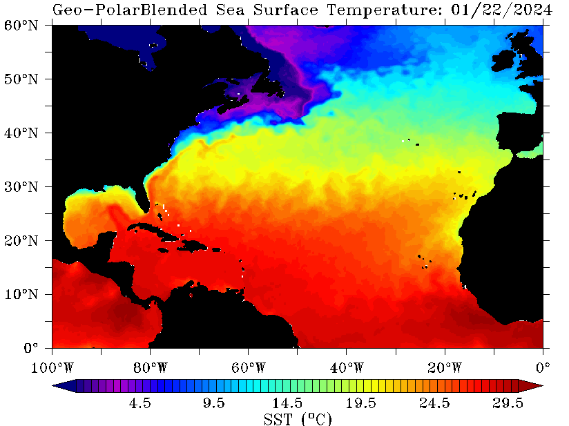

It's very hot water from here on unfortunately.

Image
1 likes   
Gloria, Hugo, Emily, Bertha, Bonnie, Dennis (twice), Fran, Floyd, Isabel, Irene, Arthur, Matthew, Florence, Dorian (and many tropical storms and nor'easters).

Exalt
Category 1
Category 1
Posts: 337
Joined: Thu Nov 26, 2015 10:55 pm

Re: ATL: FLORENCE - Hurricane - Discussion

#2083 Postby Exalt » Mon Sep 10, 2018 3:52 pm

EquusStorm wrote:Is the oceanic heat content here sufficient to have a brief Cat 5? I mean seems like the sky's the limit with other parameters but I guess that'd be a limiting factor. Not like 150 vs 157 makes an impact difference at all but it certainly does in the record books and public perceptions


Yeah, they are. Waters along the coast of SC, NC, and VA are overtly warm currently, which is reminding me of a certain hurricane from last year that continued to intensify up to landfall.
0 likes   

dspguy
Tropical Depression
Tropical Depression
Posts: 61
Joined: Wed Sep 06, 2017 2:26 pm
Location: Charleston, SC

Re: ATL: FLORENCE - Hurricane - Discussion

#2084 Postby dspguy » Mon Sep 10, 2018 3:53 pm

supercane4867 wrote:
Nimbus wrote:Looks like Florence may miss the next forecast point to the north which makes a big difference at landfall. Could be a wobble or EWRC I suppose but I'm thinking maybe the GFS was right if this verifies overnight.

Missing one forecast point slightly couldn't mean less to future track 5 days out. She also missed a forecast point earlier to its south.

Wait, it is NORTH of a forecast point suddenly? I thought it was staying south of the forecast all day. Is this something that occurred in the last few hours?
0 likes   

supercane4867
Category 5
Category 5
Posts: 4966
Joined: Wed Nov 14, 2012 10:43 am

Re: ATL: FLORENCE - Hurricane - Discussion

#2085 Postby supercane4867 » Mon Sep 10, 2018 3:53 pm

EquusStorm wrote:Is the oceanic heat content here sufficient to have a brief Cat 5? I mean seems like the sky's the limit with other parameters but I guess that'd be a limiting factor. Not like 150 vs 157 makes an impact difference at all but it certainly does in the record books and public perceptions

OHC ahead is more than sufficient to support a CAT5. Irma strengthened to 155kt under similar OHC numbers. It all comes down to the structural evolution of the storm itself.
0 likes   

dukeblue219
S2K Supporter
S2K Supporter
Posts: 535
Joined: Fri Sep 30, 2016 3:52 pm

Re: ATL: FLORENCE - Hurricane - Discussion

#2086 Postby dukeblue219 » Mon Sep 10, 2018 3:53 pm

EquusStorm wrote:Is the oceanic heat content here sufficient to have a brief Cat 5?


Yes. The theoretical max winds out there is in the 150kt range today. Plenty of heat in the ocean.
0 likes   

Chris90
Category 2
Category 2
Posts: 646
Age: 35
Joined: Thu Jun 01, 2017 9:36 pm

Re: ATL: FLORENCE - Hurricane - Discussion

#2087 Postby Chris90 » Mon Sep 10, 2018 3:54 pm

EquusStorm wrote:Is the oceanic heat content here sufficient to have a brief Cat 5? I mean seems like the sky's the limit with other parameters but I guess that'd be a limiting factor. Not like 150 vs 157 makes an impact difference at all but it certainly does in the record books and public perceptions


Here's a link to max potential intensity chart: http://wxmaps.org/pix/hurpot

Ocean can pretty much support a Cat 5 all the way to the Carolinas.
0 likes   
Solar Aquarian
Lunar Cancerian
:uarrow: Sagittarian

User avatar
tarheelprogrammer
S2K Supporter
S2K Supporter
Posts: 1793
Joined: Mon Mar 28, 2016 9:25 pm
Location: Raleigh, NC area (Garner, NC)

Re: ATL: FLORENCE - Hurricane - Discussion

#2088 Postby tarheelprogrammer » Mon Sep 10, 2018 3:55 pm

dspguy wrote:
supercane4867 wrote:
Nimbus wrote:Looks like Florence may miss the next forecast point to the north which makes a big difference at landfall. Could be a wobble or EWRC I suppose but I'm thinking maybe the GFS was right if this verifies overnight.

Missing one forecast point slightly couldn't mean less to future track 5 days out. She also missed a forecast point earlier to its south.

Wait, it is NORTH of a forecast point suddenly? I thought it was staying south of the forecast all day. Is this something that occurred in the last few hours?


It is north of almost all models and points currently.
0 likes   
My posts are not official forecasts. They are just my opinion and may or may not be backed by sound meteorological data. They are NOT endorsed by any professional institution or storm2k.org. For official information, please refer to the NHC and NWS products.

User avatar
HurricaneBelle
S2K Supporter
S2K Supporter
Posts: 1180
Joined: Sun Aug 27, 2006 6:12 pm
Location: Clearwater, FL

Re: ATL: FLORENCE - Hurricane - Discussion

#2089 Postby HurricaneBelle » Mon Sep 10, 2018 3:55 pm

Regular 5PM advisory/discussion out a little late, but the forecast marine advisory is:

INTERESTS IN THE SOUTHEASTERN AND MID-ATLANTIC STATES SHOULD MONITOR
THE PROGRESS OF FLORENCE. STORM SURGE AND HURRICANE WATCHES COULD
BE ISSUED FOR PORTIONS OF THESE AREAS BY TUESDAY MORNING.

HURRICANE CENTER LOCATED NEAR 25.4N 61.1W AT 10/2100Z
POSITION ACCURATE WITHIN 10 NM

PRESENT MOVEMENT TOWARD THE WEST-NORTHWEST OR 285 DEGREES AT 11 KT

ESTIMATED MINIMUM CENTRAL PRESSURE 939 MB
EYE DIAMETER 10 NM
MAX SUSTAINED WINDS 120 KT WITH GUSTS TO 145 KT.
0 likes   

dukeblue219
S2K Supporter
S2K Supporter
Posts: 535
Joined: Fri Sep 30, 2016 3:52 pm

Re: ATL: FLORENCE - Hurricane - Discussion

#2090 Postby dukeblue219 » Mon Sep 10, 2018 3:55 pm

dspguy wrote:
supercane4867 wrote:
Nimbus wrote:Looks like Florence may miss the next forecast point to the north which makes a big difference at landfall. Could be a wobble or EWRC I suppose but I'm thinking maybe the GFS was right if this verifies overnight.

Missing one forecast point slightly couldn't mean less to future track 5 days out. She also missed a forecast point earlier to its south.

Wait, it is NORTH of a forecast point suddenly? I thought it was staying south of the forecast all day. Is this something that occurred in the last few hours?


It's been stair-stepping/wobbling a bit today, so the overall motion is somewhat dependent on when you choose to draw a line between two points. In any case, projecting to miss a single forecast point to the north (or south) means little unless the storm is also showing sustained motion in that direction. Bottom line is that it's on track, and "track" should not be interpreted as a fixed line 1 inch across.
2 likes   

floridasun78
Category 5
Category 5
Posts: 3755
Joined: Sun May 17, 2009 10:16 pm
Location: miami fl

Re: ATL: FLORENCE - Hurricane - Discussion

#2091 Postby floridasun78 » Mon Sep 10, 2018 3:56 pm

how many plane flying now into hurr? look like more and one
0 likes   

edu2703
Category 1
Category 1
Posts: 349
Joined: Thu Aug 23, 2018 7:15 pm

Re: ATL: FLORENCE - Hurricane - Discussion

#2092 Postby edu2703 » Mon Sep 10, 2018 3:56 pm

5:00 PM AST Mon Sep 10

Location: 25.4°N 61.1°W

Moving: WNW at 13 mph

Min pressure: 939 mb

Max sustained: 140 mph
0 likes   

User avatar
cycloneye
Admin
Admin
Posts: 145749
Age: 68
Joined: Thu Oct 10, 2002 10:54 am
Location: San Juan, Puerto Rico

Re: ATL: FLORENCE - Advisories

#2093 Postby cycloneye » Mon Sep 10, 2018 3:56 pm

BULLETIN
Hurricane Florence Advisory Number 46
NWS National Hurricane Center Miami FL AL062018
500 PM AST Mon Sep 10 2018

...FLORENCE GROWING IN SIZE AND STRENGTH...
...HURRICANE AND STORM SURGE WATCHES COULD BE ISSUED TUESDAY
MORNING...


SUMMARY OF 500 PM AST...2100 UTC...INFORMATION
----------------------------------------------
LOCATION...25.4N 61.1W
ABOUT 525 MI...845 KM SSE OF BERMUDA
ABOUT 1170 MI...1880 KM ESE OF CAPE FEAR NORTH CAROLINA
MAXIMUM SUSTAINED WINDS...140 MPH...220 KM/H
PRESENT MOVEMENT...WNW OR 285 DEGREES AT 13 MPH...20 KM/H
MINIMUM CENTRAL PRESSURE...939 MB...27.73 INCHES


WATCHES AND WARNINGS
--------------------
There are no coastal watches or warnings in effect.

Interests in the southeastern and mid-Atlantic states should monitor
the progress of Florence. Storm Surge and Hurricane watches could
be issued for portions of these areas by Tuesday morning.


Hurricane Florence Discussion Number 46
NWS National Hurricane Center Miami FL AL062018
500 PM AST Mon Sep 10 2018

Unfortunately, the models were right. Florence has rapidly
intensified into an extremely dangerous hurricane, with 30-second
GOES-16 visible imagery showing well-defined eyewall mesovortices
rotating inside of the eye. A NOAA Hurricane Hunter aircraft found
peak SFMR winds of about 120 kt, with flight-level winds and
dropsonde measurements also supporting that value for the initial
wind speed estimate. Notably, the aircraft data also show the size
of the hurricane-force winds has doubled in the past 12 hours.

None of the guidance suggest that Florence has peaked in intensity,
and this is supported by a continuation of a low-shear environment,
and even warmer waters over the next 36 hours. Thus, the intensity
forecast is raised from the previous one, bringing Florence close
to category 5 strength tomorrow. Near landfall, the vertical wind
shear could increase, along with the increasing likelihood of
eyewall cycles. While the intensity forecast shows some weakening
of the maximum winds near landfall, the wind field is expected to
grow with time, which increases the storm surge and inland wind
threats. The bottom line is that there is high confidence that
Florence will be a large and extremely dangerous hurricane,
regardless of its exact intensity.

Florence has recently turned west-northwestward, still moving at 11
kt. The hurricane is expected to accelerate in that direction over
the next day or two due to building mid-level ridge over the
northwestern Atlantic Ocean. By late Wednesday, a turn toward the
northwest is forecast due to the orientation of the Atlantic ridge,
along with a decrease in forward speed due to a new ridge building
over the Great Lakes. There is a new player in the forecast as
well, with the disturbance over the northwestern Caribbean adding
some uncertainty in the ridge strength over the southeastern United
States. Perhaps it isn't surprising that the model spread has
increased on this cycle, with a small eastward shift overall. The
official forecast is nudged in the direction of the trend, but is
west of the model consensus. It is important not to focus on the
exact forecast track as average NHC errors at days 4 and 5 are about
140 and 180 n mi, respectively, and dangerous hazards will extend
well away from the center.

The NOAA G-IV jet will continue to conduct synoptic surveillance
missions every 12 h through at least Wednesday. In addition, special
0600 UTC and 1800 UTC radiosonde launches have been expanded to
additional upper-air stations across the U.S. are to collect extra
data for the numerical models.

Key Messages:

1. A life-threatening storm surge is likely along portions of the
coastlines of South Carolina, North Carolina, and Virginia, and
a Storm Surge Watch will likely be issued for some of these areas by
Tuesday morning. All interests from South Carolina into the mid-
Atlantic region should ensure they have their hurricane plan in
place and follow any advice given by local officials.

2. Life-threatening freshwater flooding is likely from a prolonged
and exceptionally heavy rainfall event, which may extend inland over
the Carolinas and Mid Atlantic for hundreds of miles as Florence is
expected to slow down as it approaches the coast and moves inland.

3. Damaging hurricane-force winds are likely along portions of the
coasts of South Carolina and North Carolina, and a Hurricane Watch
will likely be issued by Tuesday morning. Damaging winds could also
spread well inland into portions of the Carolinas and Virginia.

4. Large swells affecting Bermuda and portions of the U.S. East
Coast will continue this week, resulting in life-threatening surf
and rip currents.

FORECAST POSITIONS AND MAX WINDS

INIT 10/2100Z 25.4N 61.1W 120 KT 140 MPH
12H 11/0600Z 26.0N 63.2W 130 KT 150 MPH
24H 11/1800Z 27.0N 66.2W 135 KT 155 MPH
36H 12/0600Z 28.6N 69.3W 135 KT 155 MPH
48H 12/1800Z 30.4N 72.2W 130 KT 150 MPH
72H 13/1800Z 33.7N 77.0W 120 KT 140 MPH
96H 14/1800Z 35.6N 78.8W 50 KT 60 MPH...INLAND
120H 15/1800Z 36.5N 79.5W 25 KT 30 MPH...INLAND

$$
Forecaster Blake
0 likes   
Visit the Caribbean-Central America Weather Thread where you can find at first post web cams,radars
and observations from Caribbean basin members Click Here

User avatar
galaxy401
Category 5
Category 5
Posts: 2420
Age: 30
Joined: Sat Aug 25, 2012 9:04 pm
Location: Casa Grande, Arizona

Re: ATL: FLORENCE - Hurricane - Discussion

#2094 Postby galaxy401 » Mon Sep 10, 2018 3:56 pm

NHC now nearly predicting a category 5...
0 likes   
Got my eyes on moving right into Hurricane Alley: Florida.

jlauderdal
S2K Supporter
S2K Supporter
Posts: 7187
Joined: Wed May 19, 2004 5:46 am
Location: NE Fort Lauderdale
Contact:

Re: ATL: FLORENCE - Hurricane - Discussion

#2095 Postby jlauderdal » Mon Sep 10, 2018 3:58 pm

dukeblue219 wrote:
dspguy wrote:
supercane4867 wrote:Missing one forecast point slightly couldn't mean less to future track 5 days out. She also missed a forecast point earlier to its south.

Wait, it is NORTH of a forecast point suddenly? I thought it was staying south of the forecast all day. Is this something that occurred in the last few hours?


It's been stair-stepping/wobbling a bit today, so the overall motion is somewhat dependent on when you choose to draw a line between two points. In any case, projecting to miss a single forecast point to the north (or south) means little unless the storm is also showing sustained motion in that direction. Bottom line is that it's on track, and "track" should not be interpreted as a fixed line 1 inch across.
seems to be tracking as it should, westward motion has stopped and as usual nhc very good with track...sc/nc border 75 miles either way better prepare for the eyewall
1 likes   

BobHarlem
Category 5
Category 5
Posts: 2174
Joined: Thu Oct 20, 2005 6:11 pm

Re: ATL: FLORENCE - Hurricane - Discussion

#2096 Postby BobHarlem » Mon Sep 10, 2018 3:59 pm

From discussion: "Unfortunately, the models were right." Nearly Cat 5 forecasted. (Cat 5 on old saffir scale at 155mph before the 2012 changes)
Last edited by BobHarlem on Mon Sep 10, 2018 4:11 pm, edited 2 times in total.
1 likes   

ronyan
S2K Supporter
S2K Supporter
Posts: 791
Age: 39
Joined: Tue Sep 09, 2008 5:46 pm
Location: Lake Jackson, TX

Re: ATL: FLORENCE - Hurricane - Discussion

#2097 Postby ronyan » Mon Sep 10, 2018 3:59 pm

From the 5pm Update:

Code: Select all

Unfortunately, the models were right. Florence has rapidly
intensified into an extremely dangerous hurricane, with 30-second
GOES-16 visible imagery showing well-defined eyewall mesovortices
rotating inside of the eye. A NOAA Hurricane Hunter aircraft found
peak SFMR winds of about 120 kt, with flight-level winds and
dropsonde measurements also supporting that value for the initial
wind speed estimate. Notably, the aircraft data also show the size
of the hurricane-force winds has doubled in the past 12 hours.


Getting larger.
1 likes   

dukeblue219
S2K Supporter
S2K Supporter
Posts: 535
Joined: Fri Sep 30, 2016 3:52 pm

Re: ATL: FLORENCE - Hurricane - Discussion

#2098 Postby dukeblue219 » Mon Sep 10, 2018 4:00 pm

floridasun78 wrote:how many plane flying now into hurr? look like more and one


The NOAA G-IV is doing its thing up at 45,000 feet sampling the upper atmosphere around the storm, while the WP3 is down getting dirty in the center. A USAF WC130 is inbound now to take over for the WP3 in a few hours.
1 likes   

dukeblue219
S2K Supporter
S2K Supporter
Posts: 535
Joined: Fri Sep 30, 2016 3:52 pm

Re: ATL: FLORENCE - Hurricane - Discussion

#2099 Postby dukeblue219 » Mon Sep 10, 2018 4:01 pm

BobHarlem wrote:From discussion: "Unfortunately, the models were right." Cat 5 forecasted.


Not quite. Forecast is "just" 135 kt... a high Cat 4.
1 likes   

edu2703
Category 1
Category 1
Posts: 349
Joined: Thu Aug 23, 2018 7:15 pm

Re: ATL: FLORENCE - Hurricane - Discussion

#2100 Postby edu2703 » Mon Sep 10, 2018 4:01 pm

Image

INIT 10/2100Z 25.4N 61.1W 120 KT 140 MPH
12H 11/0600Z 26.0N 63.2W 130 KT 150 MPH
24H 11/1800Z 27.0N 66.2W 135 KT 155 MPH
36H 12/0600Z 28.6N 69.3W 135 KT 155 MPH
48H 12/1800Z 30.4N 72.2W 130 KT 150 MPH
72H 13/1800Z 33.7N 77.0W 120 KT 140 MPH
96H 14/1800Z 35.6N 78.8W 50 KT 60 MPH...INLAND
120H 15/1800Z 36.5N 79.5W 25 KT 30 MPH...INLAND
0 likes   


Return to “2018”

Who is online

Users browsing this forum: No registered users and 14 guests