Broad area of disturbed weather in the Western Caribbean Sea (Is INVEST 91L)
Moderator: S2k Moderators
Forum rules

The posts in this forum are NOT official forecasts and should not be used as such. They are just the opinion of the poster and may or may not be backed by sound meteorological data. They are NOT endorsed by any professional institution or STORM2K. For official information, please refer to products from the National Hurricane Center and National Weather Service.

Re: Broad area of disturbed weather in the Western Caribbean Sea
Looks like the slower this thing organizes and moves (drifts) N-NW, the better opportunity to stay in the NE GOM as it appears the SE ridge moves or breaks down some which allows for a more N-NE movement. A little disconcerting were the ICON and Euro runs that showed a stalling and moving east in the northern GOM. Still a lot of uncertainty next 5-7 days. And good ole GFS develops nothing still.
0 likes

Re: Broad area of disturbed weather in the Western Caribbean Sea
There is still energy in the Pacific that is robbing the Caribbean, but I imagine we will have to look in the active forum soon since the models are beginning to converge on something near the northern gulf coast.
0 likes

Re: Broad area of disturbed weather in the Western Caribbean Sea
@BenNollWeather
Following Following @BenNollWeather
More
The Gulf Coast will be on watch next week as the possibility for a tropical storm or hurricane exists.
The ECMWF ensemble suggests folks from Louisiana to Florida should pay attention to the forecast!
https://twitter.com/BenNollWeather/status/1048165523198894080
0 likes
-
p1nheadlarry

- Category 2

- Posts: 672
- Age: 34
- Joined: Wed Jan 29, 2014 2:42 pm
- Location: SR County FL
Re: Broad area of disturbed weather in the Western Caribbean Sea
NDG wrote:A lot of mid level vorticities rotating around the monsoonal gyre, including 97E.
Things usually take longer to consolidate with these big C.A. monsoonal lows and models always struggle with it, never fails. IMO.
https://i.imgur.com/hfB9AlR.gif
The westerly shear very evident
0 likes
--;->#GoNoles--;->.
-
cycloneye

- Admin

- Posts: 149276
- Age: 69
- Joined: Thu Oct 10, 2002 10:54 am
- Location: San Juan, Puerto Rico
Re: Broad area of disturbed weather in the Western Caribbean Sea
8 AM TWO:
Showers and thunderstorms associated with an area of low pressure
located near Cabo Gracias a Dios on the eastern border of Honduras
and Nicaragua have become more concentrated during the past several
hours. Although strong winds aloft are located just to the north of
this system, the upper-level environment is expected to be conducive
enough to allow slow development, and a tropical depression could
form by late this weekend or early next week over the northwestern
Caribbean Sea or southern Gulf of Mexico while the system moves
slowly northwestward. Regardless of tropical cyclone formation,
this disturbance will continue to bring torrential rains primarily
to portions of Central America and the Yucatan peninsula during the
next few days.
* Formation chance through 48 hours...low...30 percent.
* Formation chance through 5 days...medium...60 percent.
0 likes
Visit the Caribbean-Central America Weather Thread where you can find at first post web cams,radars
and observations from Caribbean basin members Click Here
and observations from Caribbean basin members Click Here
-
Dean4Storms
- S2K Supporter

- Posts: 6358
- Age: 63
- Joined: Sun Aug 31, 2003 1:01 pm
- Location: Miramar Bch. FL
Re: Broad area of disturbed weather in the Western Caribbean Sea
floridasun78 wrote:no invest because low is weak now off coast and storm are not organizing yet nhc dont invest by models only their look sat pic other data we likely see invest sat or sunday like some here been sayingDean4Storms wrote:I’m now perplexed that this isn’t an Invest yet.
Not really, we've seen them tag waves over Africa as an Invest before they ever hit the water and based solely on model support. Pressures are Low down there, pretty much unanimous model support and lots of vorticity. Like I said, a bit perplexed.
0 likes
-
SFLcane

- S2K Supporter
- Posts: 10281
- Age: 48
- Joined: Sat Jun 05, 2010 1:44 pm
- Location: Lake Worth Florida
Re: Broad area of disturbed weather in the Western Caribbean Sea
For us in Florida as wxman57 has been stating this is not a threat thanks to the semi-permanent high pressure system parked of the southeast. For the gulfcoast look out if this thing finds a pocket of low shear sst's are plenty warm for a potent storm.
1 likes
-
cycloneye
- Admin
- Posts: 149276
- Age: 69
- Joined: Thu Oct 10, 2002 10:54 am
- Location: San Juan, Puerto Rico
Re: Broad area of disturbed weather in the Western Caribbean Sea
My estimated guess is that we will have the invest sometime today. 
2 likes
Visit the Caribbean-Central America Weather Thread where you can find at first post web cams,radars
and observations from Caribbean basin members Click Here
and observations from Caribbean basin members Click Here
-
gatorcane

- S2K Supporter
- Posts: 23708
- Age: 48
- Joined: Sun Mar 13, 2005 3:54 pm
- Location: Boca Raton, FL
Re: Broad area of disturbed weather in the Western Caribbean Sea
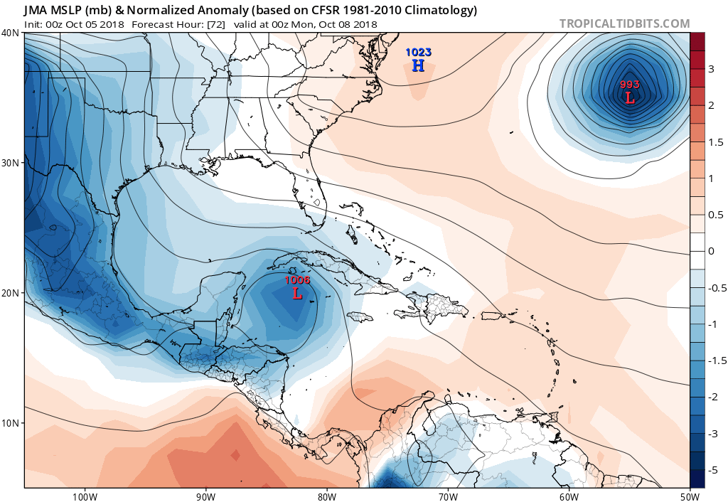
JMA sends this north to just south of Cuba:
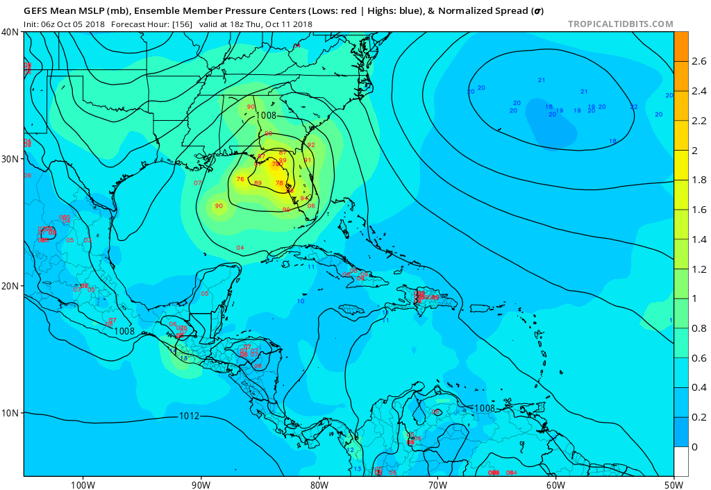
GFS ensembles big bend of Florida and west coast with some crossing South Florida:
GFS ensembles big bend of Florida and west coast with some crossing South Florida:
Last edited by gatorcane on Fri Oct 05, 2018 7:22 am, edited 1 time in total.
2 likes


Re: Broad area of disturbed weather in the Western Caribbean Sea
If this messes up my trip to Washington state next Friday, I will not be happy. The heat down here has been so endless. Temps in the 90's even into October. The gulf must be pretty hot sea temps.
0 likes
-
SFLcane
- S2K Supporter
- Posts: 10281
- Age: 48
- Joined: Sat Jun 05, 2010 1:44 pm
- Location: Lake Worth Florida
Re: Broad area of disturbed weather in the Western Caribbean Sea
Either way as the GFS ensembles show this could get close to the west coast of Florida and being a lob-sided system plenty of rain for now seems like a good bet for the peninsula.
0 likes
-
p1nheadlarry
- Category 2
- Posts: 672
- Age: 34
- Joined: Wed Jan 29, 2014 2:42 pm
- Location: SR County FL
Re: Broad area of disturbed weather in the Western Caribbean Sea
SFLcane wrote:For us in Florida as wxman57 has been stating this is not a threat thanks to the semi-permanent high pressure system parked of the southeast. For the gulfcoast look out if this thing finds a pocket of low shear sst's are plenty warm for a potent storm.
Florida *peninsula
Also it seems the GFS and ECMWF are depicting a trough to dig and temporarily weaken the ridge; the GFS showing what looks to be a shortwave helping aid in height falls. I'd say nobody should keep their eyes off of it, but I know nobody here will be doing that anyways
4 likes
--;->#GoNoles--;->.
Re: Broad area of disturbed weather in the Western Caribbean Sea
SFLcane wrote:For us in Florida as wxman57 has been stating this is not a threat thanks to the semi-permanent high pressure system parked of the southeast. For the gulfcoast look out if this thing finds a pocket of low shear sst's are plenty warm for a potent storm.
I highly doubt the above statement to be true. While it may be true for South Florida, it most certainly isnt true for West Florida or the Panhandle. As many as half of the model runs reflect a Tampa to Pensacola hit
1 likes
-
gatorcane
- S2K Supporter
- Posts: 23708
- Age: 48
- Joined: Sun Mar 13, 2005 3:54 pm
- Location: Boca Raton, FL
Re: Broad area of disturbed weather in the Western Caribbean Seat
Also with the westerly shear, wouldn’t be surprised if we see some center reformations further east so would lean towards the eastern side of the guidance (Eastern Gulf). We have seen this scenario playout countless times before with models having a west bias in these situations not to mention trying to eject systems from the Caribbean too quickly.
Last edited by gatorcane on Fri Oct 05, 2018 7:36 am, edited 2 times in total.
4 likes
Re: Broad area of disturbed weather in the Western Caribbean Sea
gatorcane wrote:Also with the westerly shear, wouldn’t be surprised if we see some center reformations so would lean towards the eastern side of the guidance
Throw in climatology too and a 50% chance seems more than reasonable of a Florida strike
0 likes
Re: Broad area of disturbed weather in the Western Caribbean Sea
Continuing trend up from GFS ensemble members for cyclogenesis over the NW Caribbean.

0 likes
-
TheStormExpert
Re: Broad area of disturbed weather in the Western Caribbean Sea
SFLcane wrote:For us in Florida as wxman57 has been stating this is not a threat thanks to the semi-permanent high pressure system parked of the southeast. For the gulfcoast look out if this thing finds a pocket of low shear sst's are plenty warm for a potent storm.
For the peninsula this is likely not a direct landfall threat, but I would not rule out a FL panhandle landfall. 06z GEFS Ensembles have trended right again and stronger, though you have to take into account that the GFS loves to break down ridges too much.
2 likes
-
Aric Dunn
- Category 5

- Posts: 21238
- Age: 43
- Joined: Sun Sep 19, 2004 9:58 pm
- Location: Ready for the Chase.
- Contact:
Re: Broad area of disturbed weather in the Western Caribbean Sea
That would be the type of convection needed to change the upper flow fliw pattern.
Also enough convection to consolidate the large gyre
And lije Cycloneye just said.. I think we will get that invest today lol.
Also enough convection to consolidate the large gyre
And lije Cycloneye just said.. I think we will get that invest today lol.
1 likes
Note: If I make a post that is brief. Please refer back to previous posts for the analysis or reasoning. I do not re-write/qoute what my initial post said each time.
If there is nothing before... then just ask
Space & Atmospheric Physicist, Embry-Riddle Aeronautical University,
I believe the sky is falling...
If there is nothing before... then just ask
Space & Atmospheric Physicist, Embry-Riddle Aeronautical University,
I believe the sky is falling...

Re: Broad area of disturbed weather in the Western Caribbean Sea
TheStormExpert wrote:SFLcane wrote:For us in Florida as wxman57 has been stating this is not a threat thanks to the semi-permanent high pressure system parked of the southeast. For the gulfcoast look out if this thing finds a pocket of low shear sst's are plenty warm for a potent storm.
For the peninsula this is likely not a direct landfall threat, but I would not rule out a FL panhandle landfall. 06z GEFS Ensembles have trended right again and stronger, though you have to take into account that the GFS loves to break down ridges too much.
Not only that we don't even have a LLC to give us any kind of certainty. It all depends on the speed and location of the developing LLC. So just having fun guessing for now. Both Bastardi(not my usual go to guy)and Wxman57 both think it is a n gulf coast landfall potential vs fl. And they are both longtime experts. But will keep tuned in to Storm2K for any changes once that LLC develops.
0 likes
Robbielyn McCrary
I know just about enough to sound like I know what I'm talking about sometimes. But for your safety please follow the nhc for truly professional forecasting.
I know just about enough to sound like I know what I'm talking about sometimes. But for your safety please follow the nhc for truly professional forecasting.
-
SFLcane
- S2K Supporter
- Posts: 10281
- Age: 48
- Joined: Sat Jun 05, 2010 1:44 pm
- Location: Lake Worth Florida
Re: Broad area of disturbed weather in the Western Caribbean Sea
TheStormExpert wrote:SFLcane wrote:For us in Florida as wxman57 has been stating this is not a threat thanks to the semi-permanent high pressure system parked of the southeast. For the gulfcoast look out if this thing finds a pocket of low shear sst's are plenty warm for a potent storm.
For the peninsula this is likely not a direct landfall threat, but I would not rule out a FL panhandle landfall. 06z GEFS Ensembles have trended right again and stronger, though you have to take into account that the GFS loves to break down ridges too much.
I meant extreme southeast florida but yea panhandle sure this could come up your way. Lets get an invest first or a well established low level circulation.
0 likes
Who is online
Users browsing this forum: No registered users and 108 guests