Cpv17 wrote:The models are all boring today

At least for DFW, the 18z GFS is a wet torch in the longer run. The upcoming cool snap gets DFW down in the 40s.
Moderator: S2k Moderators


Cpv17 wrote:The models are all boring today


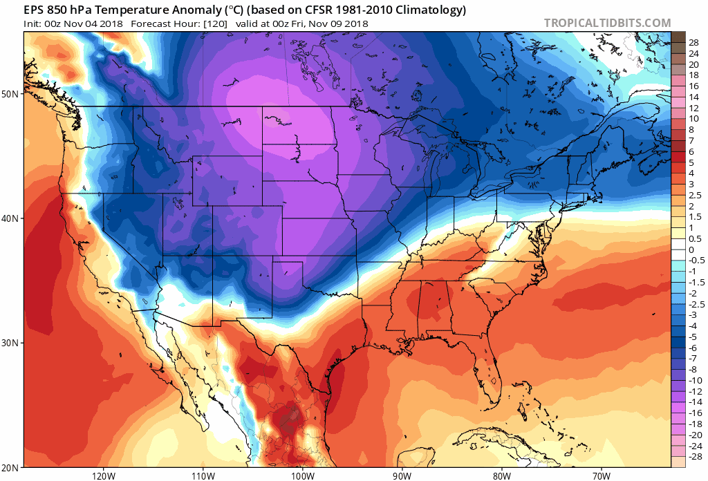
Ntxw wrote:Here is the latest back half of the EPS (Euro ensembles) which tells us pretty much the cold runs will continue at varying degrees.
https://images2.imgbox.com/33/5c/cRR2aMSo_o.gif
The snow/ice storm maps are still around 200 hours out so it is mostly novelty that comes and goes also to varying degrees depending on run. I think the NWS is going a bit conservative for late week with temps, though justified given how far that is. It is likely though many will experience the first freeze if not a hard freeze, especially outside immediate urban areas. Should be a couple waves of cold.
Luckily we have the FV3 to compare the GFS towards. I think the FV3 has better skill than the GFS regarding temperatures, it has mid 40s for highs in NTX on Friday which seems more realistic than 50s on the GFS given both shows strong CAA.
 The EPS and GEFS still have multiple days with lows in the 30s though
Brent wrote:the GFS is boring tonight. Totally lost the cold
Brent wrote:the GFS is boring tonight. Totally lost the cold


 snow coming SOON!


bubba hotep wrote:Having flashbacks to last winter with the models showing persistently lower heights across the Great Lakes and an east shifted WCAN high. Ugly NW flow with no room for a Southern Plains system to really ramp up. Hopefully, this is a transit pattern but then again the Euro EPS shows a raging +NAO and extended Pacific jet in the long rang... Even uglier. However,


