Texas Winter 2018-2019
Moderator: S2k Moderators
Forum rules
 The posts in this forum are NOT official forecast and should not be used as such. They are just the opinion of the poster and may or may not be backed by sound meteorological data. They are NOT endorsed by any professional institution or STORM2K.

The posts in this forum are NOT official forecast and should not be used as such. They are just the opinion of the poster and may or may not be backed by sound meteorological data. They are NOT endorsed by any professional institution or STORM2K.

Re: Texas Winter 2018-2019
The 0z FV3 isn't really that far off either. It is basically what the 12z Euro was.
1 likes
The above post and any post by Ntxw is NOT an official forecast and should not be used as such. It is just the opinion of the poster and may or may not be backed by sound meteorological data. It is NOT endorsed by any professional institution including Storm2k. For official information, please refer to NWS products.
Help support Storm2K!

Re: Texas Winter 2018-2019
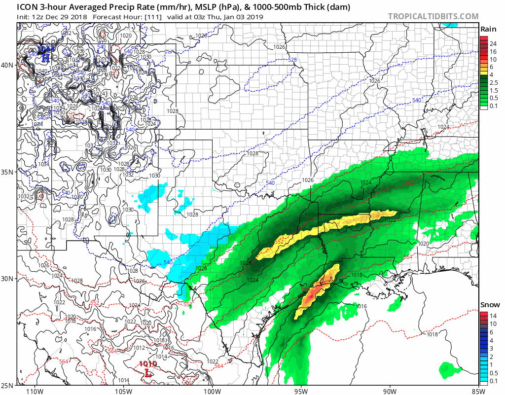
Brent wrote:0z Euro has mixed precipitation all over DFW by Wednesday afternoon
Definitely a winter storm on the Euro lol there's gonna be accumulations this run
lmao 3-6" of snow metrowide on the Euro
http://i68.tinypic.com/10i8pax.png


Cool! I'll be coming up there new years eve with family to visit family for several days. Do what you gotta do to make a snowstorm. I dont want them out there shopping the whole time:-)
2 likes


-
Ralph's Weather
- S2K Supporter

- Posts: 3371
- Age: 38
- Joined: Fri Dec 13, 2013 11:55 am
- Location: Lindale, TX
- Contact:
Re: Texas Winter 2018-2019
Looks like West Texas got some snow overnight. Some pretty videos outta El Paso.
3 likes
Follow on Facebook at Ralph's Weather.

Re: Texas Winter 2018-2019
Morning discussion from NWS FW
A cold start to the New Year can be expected with Tuesday high
temperatures ranging from the mid 30s across the northwest to the
mid and upper 40s across the southeast behind the Monday night
front. Another southern-stream low will translate the Desert
Southwest and Northern Mexico Tuesday night before reaching
Northwest Texas on Wednesday. The airmass on Wednesday may be a
little colder than this weekend, but the atmosphere will be
substantially drier. POPs will remain fairly low ahead of and
during the passage of the upper level low, with the exception of
the far southeast where 50 POPs will remain.
The low will remain cut-off as it passes over North Texas, and
partial thicknesses may allow for a transition to a wintry
mix before the system moves off to the east. However, model
discrepancies still remain too significant to justify the addition
of winter weather in the grids at this time, but will need to
keep an eye on how models handle the evolution of the system over
the next few days, and take note if future guidance advertises
colder air or deeper moisture.
Dry weather will follow during the second half of next week,
followed by a developing ridge aloft and a warm-up to near normal
temperatures as we head into next weekend.
0 likes
-
Portastorm

- Storm2k Moderator

- Posts: 9954
- Age: 63
- Joined: Fri Jul 11, 2003 9:16 am
- Location: Round Rock, TX
- Contact:
Re: Texas Winter 2018-2019
You late nighters caught first wind of it but yeah ... LOL ... that 0z Euro sure raises an eyebrow or two. It would even give us some icing here in Austin for a six-hour period with temperatures just below freezing Wednesday morning. Interesting.
3 likes
Any forecasts under my name are to be taken with a grain of salt. Get your best forecasts from the National Weather Service and National Hurricane Center.


Re: Texas Winter 2018-2019
If the Euro verifies, all us in DFW and we'll pretty much every where in Texas will be VERY happy! 

2 likes
Re: Texas Winter 2018-2019
The more the merrier.
4 likes
The above post and any post by Ntxw is NOT an official forecast and should not be used as such. It is just the opinion of the poster and may or may not be backed by sound meteorological data. It is NOT endorsed by any professional institution including Storm2k. For official information, please refer to NWS products.
Help support Storm2K!
Help support Storm2K!
-
bubba hotep

- S2K Supporter
- Posts: 6012
- Joined: Wed Dec 28, 2016 1:00 am
- Location: Collin County Texas
Re: Texas Winter 2018-2019
bubba hotep wrote:For the Wednesday system, one of the things we need to watch is the Northern Steam wave. It was much stronger on the 00z Euro and eventually overruns the system coming out of New Mexico. On the 12z today, it is barely there and stays a lot farther north allowing our system to come out of New Mexico with more amplitude.
00z Euro with strong Northern Stream wave.
https://i.ibb.co/m6HdFM9/us-model-en-087-0-modez-2018122800-108-5436-457.png
12z Euro with just a ripple in the Northern Stream
https://i.ibb.co/9vk5z4L/us-model-en-087-0-modez-2018122812-96-5436-457.png
Obviously, the 00z Euro was an even better run for N. Texas and the 3 run trend since yesterday has been moving in the right direction.

The Northern Stream vort is a bit stronger than 12z but the ULL over the Northern Hudson Bay is a bit stronger and the ridging over the NE US is adequate to produce strong confluence out over the NE. Spacing on the waves looks good as well. Below is for N. Texas December snows and would be rolled 24hrs forward from the 00z Euro image at the top of this new post, I need to add the early January events to this later today but I doubt it changes much. Pretty solid match at H5 to our analogs.

2 likes
Winter time post are almost exclusively focused on the DFW area.
-
bubba hotep
- S2K Supporter
- Posts: 6012
- Joined: Wed Dec 28, 2016 1:00 am
- Location: Collin County Texas
Re: Texas Winter 2018-2019
The Northern Stream wave that I have been harping on is currently out over the N. Pacific. The system that it is associated with plays a big role in the N. American wave break that will also play a key role in the development of our potential system. We need it to do magic over the N. Pacific and then quietly slide out of the way once it is over Canada lol

0 likes
Winter time post are almost exclusively focused on the DFW area.
-
bubba hotep
- S2K Supporter
- Posts: 6012
- Joined: Wed Dec 28, 2016 1:00 am
- Location: Collin County Texas
Re: Texas Winter 2018-2019
Anyone seeing this?
10 AM Update: We have received a few reports of some light snow pellets falling in areas north and west of the Metroplex. This should be very brief and there are no measurable accumulations expected. #txwx #texomawx #dfwwx #abilene
0 likes
Winter time post are almost exclusively focused on the DFW area.
Re: Texas Winter 2018-2019
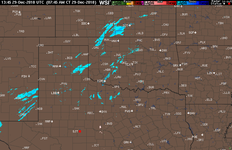
There is some radar reflection going on so not surprised some have seen flurries.
2 likes
The above post and any post by Ntxw is NOT an official forecast and should not be used as such. It is just the opinion of the poster and may or may not be backed by sound meteorological data. It is NOT endorsed by any professional institution including Storm2k. For official information, please refer to NWS products.
Help support Storm2K!
Help support Storm2K!
Re: Texas Winter 2018-2019
The 12z GFS is much slower allowing for more precipitation to build further west. Much more precip across the state and it hangs out over SETX for quite a while. San Antonio area could even get in on the action. Decent amount of freezing rain towards Austin on this run.
Last edited by Cpv17 on Sat Dec 29, 2018 11:20 am, edited 1 time in total.
3 likes
-
bubba hotep
- S2K Supporter
- Posts: 6012
- Joined: Wed Dec 28, 2016 1:00 am
- Location: Collin County Texas
Re: Texas Winter 2018-2019
Also, there was a big shift towards a winter wx system on the 00z Euro EPS with the Control Run and about 50% of the members showing some kind of event for N & NE Texas.
1 likes
Winter time post are almost exclusively focused on the DFW area.
Re: Texas Winter 2018-2019
With decent cold air advection and heavy cloud cover, DFW may not make it to 40 today.
3 likes
The above post and any post by Ntxw is NOT an official forecast and should not be used as such. It is just the opinion of the poster and may or may not be backed by sound meteorological data. It is NOT endorsed by any professional institution including Storm2k. For official information, please refer to NWS products.
Help support Storm2K!
Help support Storm2K!
-
bubba hotep
- S2K Supporter
- Posts: 6012
- Joined: Wed Dec 28, 2016 1:00 am
- Location: Collin County Texas
Re: Texas Winter 2018-2019
While we wait on the 12z Euro to run, lets take a quick look at the minor differences in the 12z GFS, 06z FV3, and 00z Euro - all images 00z Wednesday.
12z GFS

06z FV3

00z Euro

Start in WCAN and work your way East paying attention to the orientation of the WCAN ridge, our system in the SW, PV lobe over the Northern Hudson Bay, the Northern Stream wave, and ridging over the SE into the NE. Minor differences but they make a world of difference in our potential weather next Wednesday. Hopefully, over the next 24 to 36 hrs things will start to lock in as the models process the wave break into WCAN.
12z GFS
06z FV3
00z Euro
Start in WCAN and work your way East paying attention to the orientation of the WCAN ridge, our system in the SW, PV lobe over the Northern Hudson Bay, the Northern Stream wave, and ridging over the SE into the NE. Minor differences but they make a world of difference in our potential weather next Wednesday. Hopefully, over the next 24 to 36 hrs things will start to lock in as the models process the wave break into WCAN.
1 likes
Winter time post are almost exclusively focused on the DFW area.
-
bubba hotep
- S2K Supporter
- Posts: 6012
- Joined: Wed Dec 28, 2016 1:00 am
- Location: Collin County Texas
Re: Texas Winter 2018-2019
I wasn't planning on running today due to the cold but the chance to see some snow pellets might get moving lol
From FWD:
From FWD:
10:37 AM: Areas N of I-20 and W of a Bonham/Rockwall line may see light showers or snow pellets through mid afternoon. Temps are in the low to mid 30s, but the ground is a little warmer, so these pellets should melt quickly. No road impacts expected. #texomawx #dfwwx #Abilene
2 likes
Winter time post are almost exclusively focused on the DFW area.
-
bubba hotep
- S2K Supporter
- Posts: 6012
- Joined: Wed Dec 28, 2016 1:00 am
- Location: Collin County Texas
Re: Texas Winter 2018-2019
Last post until the Euro, we were on pace for 100 pages in December but have fallen behind. We have 3 days to rally and a potential winter wx event to track, lets go!  :snow:
:snow:
4 likes
Winter time post are almost exclusively focused on the DFW area.
-
Portastorm
- Storm2k Moderator
- Posts: 9954
- Age: 63
- Joined: Fri Jul 11, 2003 9:16 am
- Location: Round Rock, TX
- Contact:
Re: Texas Winter 2018-2019
Cpv17 wrote:The 12z GFS is much slower allowing for more precipitation to build further west. Much more precip across the state and it hangs out over SETX for quite a while. San Antonio area could even get in on the action. Decent amount of freezing rain towards Austin on this run.
Yeah, 12z GFS with an ugly icing event for Austin. Has a sharp gradient for precip as well. My takeaway is GFS trending colder for next week per the Euro.
1 likes
Any forecasts under my name are to be taken with a grain of salt. Get your best forecasts from the National Weather Service and National Hurricane Center.
Re: Texas Winter 2018-2019
The CMC and GFS group (compared to the Euro) are not as amped. See Bubba's posts above.
Really the Euro is kind of doing its thing right now mostly, will it win with its medium range prowess? 12z Ukmet looks more like the Euro than the prior bunch. Guess we'll find out in an hour if it was a fluke run or something possible.
Really the Euro is kind of doing its thing right now mostly, will it win with its medium range prowess? 12z Ukmet looks more like the Euro than the prior bunch. Guess we'll find out in an hour if it was a fluke run or something possible.
1 likes
The above post and any post by Ntxw is NOT an official forecast and should not be used as such. It is just the opinion of the poster and may or may not be backed by sound meteorological data. It is NOT endorsed by any professional institution including Storm2k. For official information, please refer to NWS products.
Help support Storm2K!
Help support Storm2K!
Who is online
Users browsing this forum: Brent, steviegcomeback and 25 guests