Texas Winter 2018-2019
Moderator: S2k Moderators
Forum rules
 The posts in this forum are NOT official forecast and should not be used as such. They are just the opinion of the poster and may or may not be backed by sound meteorological data. They are NOT endorsed by any professional institution or STORM2K.

The posts in this forum are NOT official forecast and should not be used as such. They are just the opinion of the poster and may or may not be backed by sound meteorological data. They are NOT endorsed by any professional institution or STORM2K.
-
bubba hotep

- S2K Supporter

- Posts: 6012
- Joined: Wed Dec 28, 2016 1:00 am
- Location: Collin County Texas
Re: Texas Winter 2018-2019
Congrats to those that got snow!
5 likes
Winter time post are almost exclusively focused on the DFW area.

Re: Texas Winter 2018-2019
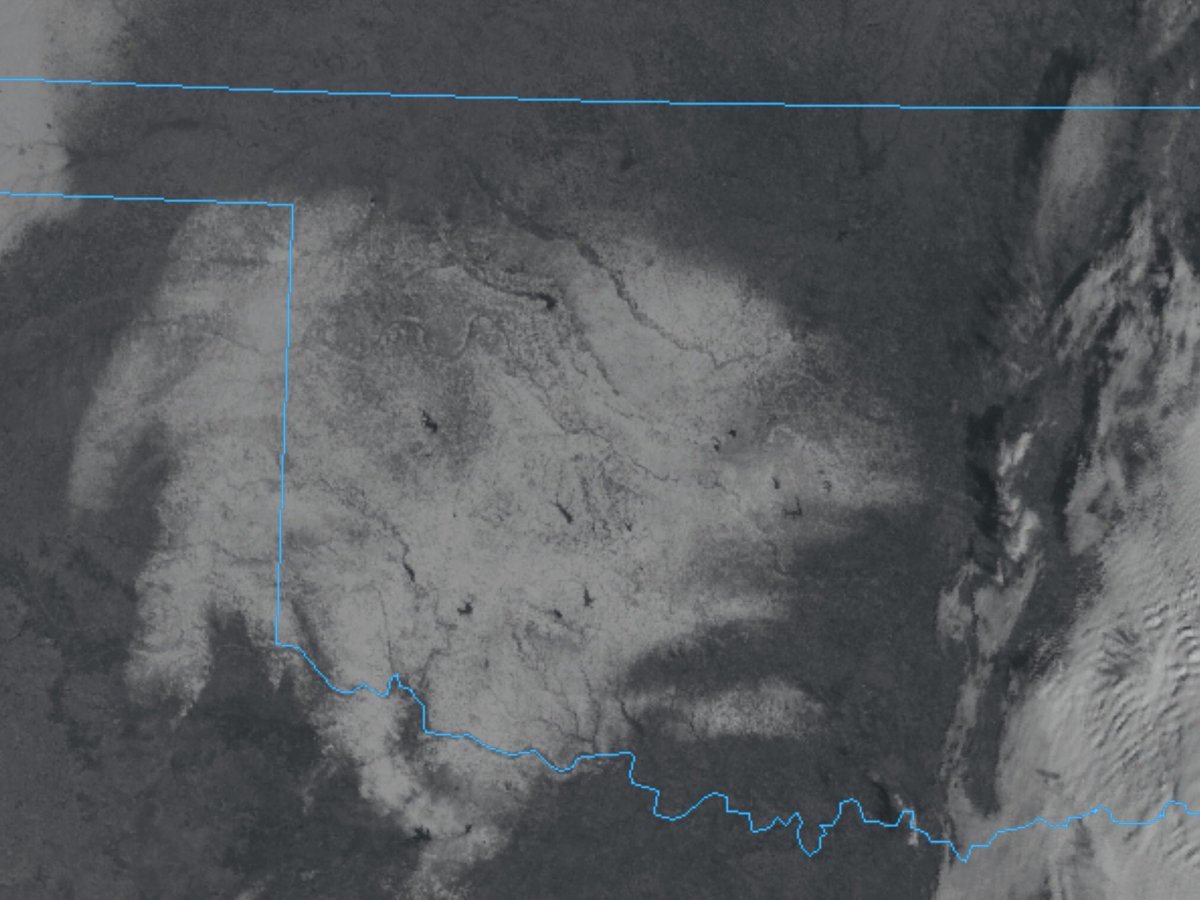
Officially 2.5" at WF and 4.5" in Oklahoma City.
4 likes
The above post and any post by Ntxw is NOT an official forecast and should not be used as such. It is just the opinion of the poster and may or may not be backed by sound meteorological data. It is NOT endorsed by any professional institution including Storm2k. For official information, please refer to NWS products.
Help support Storm2K!
-
bubba hotep
- S2K Supporter
- Posts: 6012
- Joined: Wed Dec 28, 2016 1:00 am
- Location: Collin County Texas
Re: Texas Winter 2018-2019
Another view,

0 likes
Winter time post are almost exclusively focused on the DFW area.
-
Yukon Cornelius
- S2K Supporter
- Posts: 1838
- Age: 42
- Joined: Thu Dec 20, 2012 9:23 pm
- Location: Dean, TX/Westcliffe, CO


Re: Texas Winter 2018-2019
Just watched JB's new video. He's convinced it's coming. Has snow all the way down to the Gulf Coast in the very last part of the video.
3 likes
-
TeamPlayersBlue

- Category 5

- Posts: 3524
- Joined: Tue Feb 02, 2010 1:44 am
- Location: Denver/Applewood, CO
Re: Texas Winter 2018-2019
Is this what they call a "barbell winter?" Cold at the beginning- warm in the middle- cold at the end. I dont remember the exact years, but we had similar winter to this in the 2000's. Still waiting on the MJO and the results from the SSW....
0 likes
Personal Forecast Disclaimer:
The posts in this forum are NOT official forecast and should not be used as such. They are just the opinion of the poster and may or may not be backed by sound meteorological data. They are NOT endorsed by any professional institution or storm2k.org. For official information, please refer to the NHC and NWS products.
The posts in this forum are NOT official forecast and should not be used as such. They are just the opinion of the poster and may or may not be backed by sound meteorological data. They are NOT endorsed by any professional institution or storm2k.org. For official information, please refer to the NHC and NWS products.
-
orangeblood
- S2K Supporter
- Posts: 3895
- Joined: Tue Dec 15, 2009 6:14 pm
- Location: Fort Worth, TX
Re: Texas Winter 2018-2019
We've seen it time and time again over the years...when you see MEAN negative anomalies show up in the longer term like this, probability levels begin rising for potential severe cold outbreaks. There are some wildly cold GFS members towards this end of this run, particularly in Canada

1 likes
Re: Texas Winter 2018-2019
I wonder when this is going to show up in the operational models?
0 likes
-
orangeblood
- S2K Supporter
- Posts: 3895
- Joined: Tue Dec 15, 2009 6:14 pm
- Location: Fort Worth, TX
Re: Texas Winter 2018-2019
harp wrote:I wonder when this is going to show up in the operational models?
For Arctic Outbreaks, It can show up on any given run but nothing to take too serious until we get less than 9-10 days out. For individual winter storms, that drops to 4-5 days out
1 likes
Re: Texas Winter 2018-2019
orangeblood wrote:harp wrote:I wonder when this is going to show up in the operational models?
It can show up on any given run but nothing to take too serious until we get less than 9-10 days out
Ok ,thanks for the response. I'm new here but just as weather nerdy as the rest of ya!
4 likes
-
wxman57

- Moderator-Pro Met

- Posts: 23170
- Age: 68
- Joined: Sat Jun 21, 2003 8:06 pm
- Location: Houston, TX (southwest)
Re: Texas Winter 2018-2019
12Z GFS has snow threatening D-FW area NEXT Sunday (13th). I'm sure you'll get some snow out of that storm...
5 likes
-
cheezyWXguy

- Category 5
- Posts: 6280
- Joined: Mon Feb 13, 2006 12:29 am
- Location: Dallas, TX
Re: Texas Winter 2018-2019
wxman57 wrote:12Z GFS has snow threatening D-FW area NEXT Sunday (13th). I'm sure you'll get some snow out of that storm...
Ha, I just saw that. Looks like a redo of what we just dealt with. Not holding my breath this time...
2 likes
-
Portastorm

- Storm2k Moderator

- Posts: 9954
- Age: 63
- Joined: Fri Jul 11, 2003 9:16 am
- Location: Round Rock, TX
- Contact:
Re: Texas Winter 2018-2019
wxman57 wrote:12Z GFS has snow threatening D-FW area NEXT Sunday (13th). I'm sure you'll get some snow out of that storm...
(Referee throws yellow flag and says): "Personal foul. Unsportsmanslike conduct by wxman57. 15 yards and a first down for the Metroplexers."
8 likes
Any forecasts under my name are to be taken with a grain of salt. Get your best forecasts from the National Weather Service and National Hurricane Center.

Re: Texas Winter 2018-2019
Portastorm wrote:wxman57 wrote:12Z GFS has snow threatening D-FW area NEXT Sunday (13th). I'm sure you'll get some snow out of that storm...
(Referee throws yellow flag and says): "Personal foul. Unsportsmanslike conduct by wxman57. 15 yards and a first down for the Metroplexers."
We need that first down because we haven’t won a game in years!! 0-16 last year again!
2 likes
Graduate Meteorology Student at the University of Oklahoma!
All opinions independent of employers and the university.
All opinions independent of employers and the university.
-
spencer817

- Tropical Storm

- Posts: 197
- Age: 27
- Joined: Thu Nov 17, 2016 3:22 pm
- Location: Coppell, TX
Re: Texas Winter 2018-2019
Cerlin wrote:Portastorm wrote:wxman57 wrote:12Z GFS has snow threatening D-FW area NEXT Sunday (13th). I'm sure you'll get some snow out of that storm...
(Referee throws yellow flag and says): "Personal foul. Unsportsmanslike conduct by wxman57. 15 yards and a first down for the Metroplexers."
We need that first down because we haven’t won a game in years!! 0-16 last year again!
0-3 this year too, some close games but no wins!
1 likes
I'm going to go to school for this stuff 
-
Texas Snowman

- Storm2k Moderator
- Posts: 6197
- Joined: Fri Jan 25, 2008 11:29 am
- Location: Denison, Texas
Re: Texas Winter 2018-2019
Portastorm wrote:wxman57 wrote:12Z GFS has snow threatening D-FW area NEXT Sunday (13th). I'm sure you'll get some snow out of that storm...
(Referee throws yellow flag and says): "Personal foul. Unsportsmanslike conduct by wxman57. 15 yards and a first down for the Metroplexers."
Personally, I think that was targeting by Wxman57. 15 yard penalty and Wxman57 is disqualified from the contest.

2 likes
The above post and any post by Texas Snowman is NOT an official forecast and should not be used as such. It is just the opinion of the poster and may or may not be backed by sound meteorological data. It is NOT endorsed by any professional institution including storm2k.org. For official information, please refer to NWS products.

Re: Texas Winter 2018-2019
Portastorm wrote:wxman57 wrote:12Z GFS has snow threatening D-FW area NEXT Sunday (13th). I'm sure you'll get some snow out of that storm...
(Referee throws yellow flag and says): "Personal foul. Unsportsmanslike conduct by wxman57. 15 yards and a first down for the Metroplexers."
You forgot to mention that's was his 100 plus unsportsmanlike like penalty..... He has also been ejected!!!!!
2 likes
Re: Texas Winter 2018-2019
Here is your first sign the Pacific is changing below with the SOI crash. Tahiti's pressures is lowering while Darwin's is rising. These mean tropical convection is moving out of the Maritimes/WPAC and into the Central Pacific. Continuous retrogression of the Aleutian low to follow the convection pullback from the IO which raises heights over western North America. SSW is a very slow process as the MSLP configuration changes from warmer Arctic to colder Continents. We like to think of SSW as instant game changers but top down events are not. It took heat fluxes from October to November to get the vortex perturbed then split didn't happen until this past week. The circulations will take a few weeks longer to propagate downward as it is not a bottom-up event.
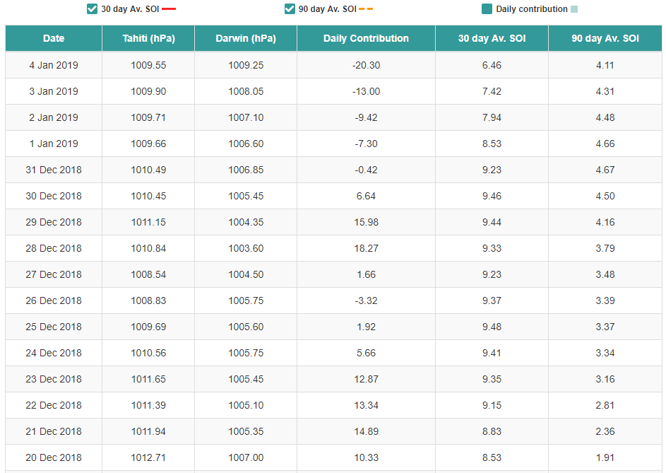
There is a small set of years with warm ENSO and a flip from +Dec soi to -Jan since 1950. Those years are 2003-2004, 1993-1994, 1969-1970, 1968-1969, 1965-1966. These are not all analogs only the complete reversal of the SOI in a particular ENSO state.
There is a small set of years with warm ENSO and a flip from +Dec soi to -Jan since 1950. Those years are 2003-2004, 1993-1994, 1969-1970, 1968-1969, 1965-1966. These are not all analogs only the complete reversal of the SOI in a particular ENSO state.
5 likes
The above post and any post by Ntxw is NOT an official forecast and should not be used as such. It is just the opinion of the poster and may or may not be backed by sound meteorological data. It is NOT endorsed by any professional institution including Storm2k. For official information, please refer to NWS products.
Help support Storm2K!
Help support Storm2K!
-
Tireman4

- S2K Supporter
- Posts: 5903
- Age: 60
- Joined: Fri Jun 30, 2006 1:08 pm
- Location: Humble, Texas
- Contact:
Re: Texas Winter 2018-2019
EnnisTx wrote:Portastorm wrote:wxman57 wrote:12Z GFS has snow threatening D-FW area NEXT Sunday (13th). I'm sure you'll get some snow out of that storm...
(Referee throws yellow flag and says): "Personal foul. Unsportsmanslike conduct by wxman57. 15 yards and a first down for the Metroplexers."
You forgot to mention that's was his 100 plus unsportsmanlike like penalty..... He has also been ejected!!!!!
And he is on notice that he could be suspended from the Snow League...
1 likes

Re: Texas Winter 2018-2019
Ntxw wrote:Here is your first sign the Pacific is changing below with the SOI crash. Tahiti's pressures is lowering while Darwin's is rising. These mean tropical convection is moving out of the Maritimes/WPAC and into the Central Pacific. Continuous retrogression of the Aleutian low to follow the convection pullback from the IO which raises heights over western North America. SSW is a very slow process as the MSLP configuration changes from warmer Arctic to colder Continents. We like to think of SSW as instant game changers but top down events are not. It took heat fluxes from October to November to get the vortex perturbed then split didn't happen until this past week. The circulations will take a few weeks longer to propagate downward as it is not a bottom-up event.
https://images2.imgbox.com/ee/d6/sUXJflyd_o.png
There is a small set of years with warm ENSO and a flip from +Dec soi to -Jan since 1950. Those years are 2003-2004, 1993-1994, 1969-1970, 1968-1969, 1965-1966. These are not all analogs only the complete reversal of the SOI in a particular ENSO state.
It’s strange because I saw many winter forecasts that called for below average rain for the NW and it’s been anything but that. They’ve been getting slammed with deluge after deluge and some of the higher elevated areas around there and in far SW Canada have measured snow totals by the dozens.
0 likes
Who is online
Users browsing this forum: South Texas Storms and 176 guests