

Texas Winter 2018-2019
Moderator: S2k Moderators
Forum rules
 The posts in this forum are NOT official forecast and should not be used as such. They are just the opinion of the poster and may or may not be backed by sound meteorological data. They are NOT endorsed by any professional institution or STORM2K.

The posts in this forum are NOT official forecast and should not be used as such. They are just the opinion of the poster and may or may not be backed by sound meteorological data. They are NOT endorsed by any professional institution or STORM2K.
Re: Texas Winter 2018-2019
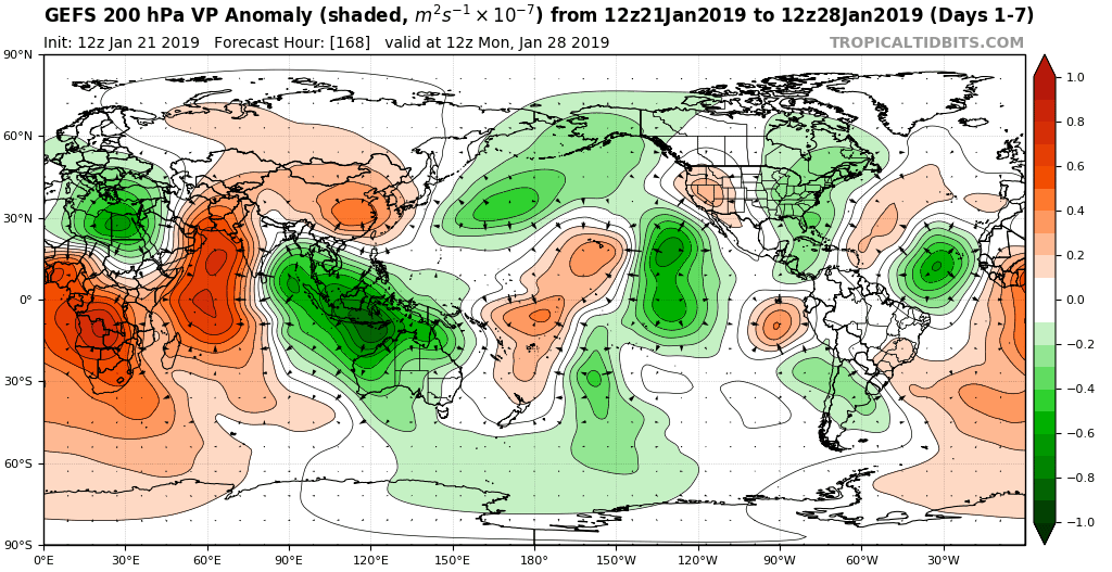
I think the reason we have seen some discrepencies between the AAM and some models not matching up/volatile is likely because of the divergence in the Maritime continent/Indonesia. This is unusual for a Nino event but it should relax and the Pacific takes over. Natural retrogression and STJ amplification. Lots of mumbo jumbo.
2 likes
The above post and any post by Ntxw is NOT an official forecast and should not be used as such. It is just the opinion of the poster and may or may not be backed by sound meteorological data. It is NOT endorsed by any professional institution including Storm2k. For official information, please refer to NWS products.
Help support Storm2K!
-
Ralph's Weather
- S2K Supporter

- Posts: 3371
- Age: 38
- Joined: Fri Dec 13, 2013 11:55 am
- Location: Lindale, TX
- Contact:
Re: Texas Winter 2018-2019
Cpv17 wrote:How would this setup not produce anything? Please enlighten me.
https://www.tropicaltidbits.com/analysis/models/ecmwf/2019012112/ecmwf_z500a_namer_10.png
https://www.tropicaltidbits.com/analysis/models/ecmwf/2019012112/ecmwf_T850a_scus_10.png
I mean, how would it look any better than that?
It would produce, I mean ideally the EPO ridge could be a tad further W but that set up would work.
1 likes
Follow on Facebook at Ralph's Weather.

Re: Texas Winter 2018-2019
Well this map isn’t something you see every day, that’s for sure! Still too far east imo though. I’d move that west about 100-200 miles.

This looks a bit interesting..some green showing back up in Deep South Texas. Maybe a sign of moisture coming back?

This looks a bit interesting..some green showing back up in Deep South Texas. Maybe a sign of moisture coming back?
0 likes
-
Ralph's Weather
- S2K Supporter
- Posts: 3371
- Age: 38
- Joined: Fri Dec 13, 2013 11:55 am
- Location: Lindale, TX
- Contact:
Re: Texas Winter 2018-2019
Cpv17 wrote:bubba hotep wrote:Euro EPS is much more favorable for winter wx across Texas in the 7-10D range than the 00z was, even though the 12z Op wasn't as good of a look.
Bubba, you’re very knowledgeable about the weather! Please tell me how this produces precip over Texas
https://www.tropicaltidbits.com/analysis/models/ecmwf/2019012112/ecmwf_z500a_namer_3.png
But this doesn’t?
https://www.tropicaltidbits.com/analysis/models/ecmwf/2019012112/ecmwf_z500a_namer_10.png
Makes no sense to me

It would, that is a good look. I am not worried about surface output right now at that range. The upper patter is great. That would produce a winter storm from TX through the South.
0 likes
Follow on Facebook at Ralph's Weather.
Re: Texas Winter 2018-2019
Ralph's Weather wrote:Cpv17 wrote:How would this setup not produce anything? Please enlighten me.
https://www.tropicaltidbits.com/analysis/models/ecmwf/2019012112/ecmwf_z500a_namer_10.png
https://www.tropicaltidbits.com/analysis/models/ecmwf/2019012112/ecmwf_T850a_scus_10.png
I mean, how would it look any better than that?
It would produce, I mean ideally the EPO ridge could be a tad further W but that set up would work.
I’d like to see the highest heights more towards the Gulf of Alaska instead of Graham Island.
1 likes
-
Ralph's Weather
- S2K Supporter
- Posts: 3371
- Age: 38
- Joined: Fri Dec 13, 2013 11:55 am
- Location: Lindale, TX
- Contact:
Re: Texas Winter 2018-2019
95% of Euro members give me snow Wed morning. Max amount is around 3" and most down under an inch. Also some will likely be lost to sleet as the 850 0 degree line is trailing the surface freezing line. If that 850 0 degree line could advance a bit faster I'd be dumped on good. Hoping for no freezing rain.
GFS ensemble mean maxes at over 2" of snow Wed morning over Carthage with some members nearing 6" over southern E TX.
Other models finally picking up on this event.
Wed morning is going to surprise some folks in E TX.
GFS ensemble mean maxes at over 2" of snow Wed morning over Carthage with some members nearing 6" over southern E TX.
Other models finally picking up on this event.
Wed morning is going to surprise some folks in E TX.
2 likes
Follow on Facebook at Ralph's Weather.
-
orangeblood
- S2K Supporter
- Posts: 3895
- Joined: Tue Dec 15, 2009 6:14 pm
- Location: Fort Worth, TX
Re: Texas Winter 2018-2019
Ralph's Weather wrote:Cpv17 wrote:bubba hotep wrote:Euro EPS is much more favorable for winter wx across Texas in the 7-10D range than the 00z was, even though the 12z Op wasn't as good of a look.
Bubba, you’re very knowledgeable about the weather! Please tell me how this produces precip over Texas
https://www.tropicaltidbits.com/analysis/models/ecmwf/2019012112/ecmwf_z500a_namer_3.png
But this doesn’t?
https://www.tropicaltidbits.com/analysis/models/ecmwf/2019012112/ecmwf_z500a_namer_10.png
Makes no sense to me
It would, that is a good look. I am not worried about surface output right now at that range. The upper patter is great. That would produce a winter storm from TX through the South.
Those two maps are different in actuality, first one is more of a neutral trough and the other is a positively tilted trough....you get more dynamic lift and moisture return with the former not the latter
0 likes
-
hamburgerman7070
- Category 1

- Posts: 253
- Joined: Sat Dec 02, 2017 7:39 pm
- Location: Jonesboro ar
Re: Texas Winter 2018-2019
Ntxw wrote:I think the reason we have seen some discrepencies between the AAM and some models not matching up/volatile is likely because of the divergence in the Maritime continent/Indonesia. This is unusual for a Nino event but it should relax and the Pacific takes over. Natural retrogression and STJ amplification. Lots of mumbo jumbo.
https://images2.imgbox.com/97/7e/H9zAtRRK_o.gif
Ntxw, do you think the models will resolve things as time goes on? What is the main thing we need to watch for moving forward to see if we can get in a more favorable pattern for winter weather?
0 likes
-
Lagreeneyes03
- Category 2

- Posts: 608
- Joined: Mon Dec 09, 2013 10:53 am
- Location: Luxurious Lake Grapevine
Re: Texas Winter 2018-2019
Ralph's Weather wrote:95% of Euro members give me snow Wed morning. Max amount is around 3" and most down under an inch. Also some will likely be lost to sleet as the 850 0 degree line is trailing the surface freezing line. If that 850 0 degree line could advance a bit faster I'd be dumped on good. Hoping for no freezing rain.
GFS ensemble mean maxes at over 2" of snow Wed morning over Carthage with some members nearing 6" over southern E TX.
Other models finally picking up on this event.
Wed morning is going to surprise some folks in E TX.
What do we have to do to get some of this in DFW?...we just keep missing out on anything but a flurry.
2 likes
I'm a Princess, not a forecaster.
-
sphelps8681
- Category 2
- Posts: 785
- Joined: Thu Aug 16, 2007 5:37 pm
- Location: Somewhere over the rainbow
Re: Texas Winter 2018-2019
Ralph's Weather wrote:95% of Euro members give me snow Wed morning. Max amount is around 3" and most down under an inch. Also some will likely be lost to sleet as the 850 0 degree line is trailing the surface freezing line. If that 850 0 degree line could advance a bit faster I'd be dumped on good. Hoping for no freezing rain.
GFS ensemble mean maxes at over 2" of snow Wed morning over Carthage with some members nearing 6" over southern E TX.
Other models finally picking up on this event.
Wed morning is going to surprise some folks in E TX.
What parts of E Tx?
0 likes
Re: Texas Winter 2018-2019
hamburgerman7070 wrote:Ntxw wrote:I think the reason we have seen some discrepencies between the AAM and some models not matching up/volatile is likely because of the divergence in the Maritime continent/Indonesia. This is unusual for a Nino event but it should relax and the Pacific takes over. Natural retrogression and STJ amplification. Lots of mumbo jumbo.
https://images2.imgbox.com/97/7e/H9zAtRRK_o.gif
Ntxw, do you think the models will resolve things as time goes on? What is the main thing we need to watch for moving forward to see if we can get in a more favorable pattern for winter weather?
I'm not sure if the models will resolve, just noting what could be the reason there are discrepencies between one run to another, or even against historical 500mb patterns. The two dueling low freq tropical forcing has effects on both the PNA and NAO in particular. +AAM with convection over the Maritime Continent is quite unusual.
0 likes
The above post and any post by Ntxw is NOT an official forecast and should not be used as such. It is just the opinion of the poster and may or may not be backed by sound meteorological data. It is NOT endorsed by any professional institution including Storm2k. For official information, please refer to NWS products.
Help support Storm2K!
Help support Storm2K!
-
Haris

- Category 5

- Posts: 1814
- Joined: Mon Nov 27, 2017 8:19 pm
- Location: ( Bee Cave) West Austin, Texas
Re: Texas Winter 2018-2019
The EPS are fairly snowy. The future is very foggy beyond Wednesday for sure. Could be another dud or an actual event. Too early to write anything off the table.
4 likes
Weather geek and a storm spotter in West Austin. Not a degreed meteorologist. Big snow fan. Love rain and cold! Despise heat!
-
orangeblood
- S2K Supporter
- Posts: 3895
- Joined: Tue Dec 15, 2009 6:14 pm
- Location: Fort Worth, TX
Re: Texas Winter 2018-2019
Haris wrote:The EPS are fairly snowy. The future is very foggy beyond Wednesday for sure. Could be another dud or an actual event. Too early to write anything off the table.
Unfortunately, at least to my eyes, they don't look as promising...mean trough axis has trended east, not west, and only showing Mean QPF at DFW of around 0.45 inch over next 15 days. That is on the dry side for DFW this time of year! Plus an even more disturbing trend on the Euro EPS is it's lifting the cold north after Day 11-12. As far as cold goes over next 10 days, it looks better, but not on the moisture side of the equation
0 likes
-
wxman57

- Moderator-Pro Met

- Posts: 23170
- Age: 68
- Joined: Sat Jun 21, 2003 8:06 pm
- Location: Houston, TX (southwest)
Re: Texas Winter 2018-2019
orangeblood wrote:Haris wrote:The EPS are fairly snowy. The future is very foggy beyond Wednesday for sure. Could be another dud or an actual event. Too early to write anything off the table.
Unfortunately, at least to my eyes, they don't look as promising...mean trough axis has trended east, not west, and only showing Mean QPF at DFW of around 0.45 inch over next 15 days. That is on the dry side for DFW this time of year!
If we do get snow from a low in the Gulf, then the place to look is well south of the D-FW area, as the moisture typically doesn't extend too far inland. Heck, the Euro has the low so far south that the snow is south of Houston! Of course, that's assuming that the models are right for next week, which is a big assumption (and each model has a different solution).
I have to admit, by the way, that model runs for next week and beyond are starting to look "interesting" for snow lovers. An influx of fresh Canadian air may set the stage for multiple events, even down to the Gulf Coast.
6 likes

Re: Texas Winter 2018-2019
Wooooo! Only 384 hours out - it can't be wrong this time?! 

0 likes
The above post and any post by dhweather is NOT an official forecast and should not be used as such. It is just the opinion of the poster and may or may not be backed by sound meteorological data. It is NOT endorsed by any professional institution including storm2k.org. For official information, please refer to NWS products.
Re: Texas Winter 2018-2019
Haris wrote:euro has a hurricane off of Florida LMAO
But it's not in the Gulf.
0 likes
The above post and any post by dhweather is NOT an official forecast and should not be used as such. It is just the opinion of the poster and may or may not be backed by sound meteorological data. It is NOT endorsed by any professional institution including storm2k.org. For official information, please refer to NWS products.
-
Brent
- S2K Supporter
- Posts: 38705
- Age: 37
- Joined: Sun May 16, 2004 10:30 pm
- Location: Tulsa Oklahoma
- Contact:
Re: Texas Winter 2018-2019
Lagreeneyes03 wrote:Ralph's Weather wrote:95% of Euro members give me snow Wed morning. Max amount is around 3" and most down under an inch. Also some will likely be lost to sleet as the 850 0 degree line is trailing the surface freezing line. If that 850 0 degree line could advance a bit faster I'd be dumped on good. Hoping for no freezing rain.
GFS ensemble mean maxes at over 2" of snow Wed morning over Carthage with some members nearing 6" over southern E TX.
Other models finally picking up on this event.
Wed morning is going to surprise some folks in E TX.
What do we have to do to get some of this in DFW?...we just keep missing out on anything but a flurry.
Seriously so much talk about being our year and nothing to show for it
1 likes
#neversummer
Re: Texas Winter 2018-2019
Portastorm wrote:I realize everyone is frustrated because it always seems like the "goods" get delivered in the models 10 days out. We'd all feel a lot better if the models were in agreement 72 hours out. But in reviewing this morning the ensembles for all three medium range models, you have to admit it's impressive to see such agreement in a pattern which would, theoretically, deliver the "goods" for us in the Southern Plains and Texas.
Let's hope it holds and verifies. This time.
The check is in the mail.
This won't hurt a bit.
There was no pass interference.
1 likes
The above post and any post by dhweather is NOT an official forecast and should not be used as such. It is just the opinion of the poster and may or may not be backed by sound meteorological data. It is NOT endorsed by any professional institution including storm2k.org. For official information, please refer to NWS products.
-
hamburgerman7070
- Category 1
- Posts: 253
- Joined: Sat Dec 02, 2017 7:39 pm
- Location: Jonesboro ar
Re: Texas Winter 2018-2019
orangeblood wrote:Haris wrote:The EPS are fairly snowy. The future is very foggy beyond Wednesday for sure. Could be another dud or an actual event. Too early to write anything off the table.
Unfortunately, at least to my eyes, they don't look as promising...mean trough axis has trended east, not west, and only showing Mean QPF at DFW of around 0.45 inch over next 15 days. That is on the dry side for DFW this time of year! Plus an even more disturbing trend on the Euro EPS is it's lifting the cold north after Day 11-12. As far as cold goes over next 10 days, it looks better, but not on the moisture side of the equation
Orangeblood, I hate to be a debbie downer, but i think winter is over other than a few cold shots. Trough is too far east and then it starts to moderate late in the period. Only way imo we can salvage winter is if we get a -nao, otherwise its coming to an abrupt end imo.
1 likes
-
Lagreeneyes03
- Category 2
- Posts: 608
- Joined: Mon Dec 09, 2013 10:53 am
- Location: Luxurious Lake Grapevine
Re: Texas Winter 2018-2019
hamburgerman7070 wrote:orangeblood wrote:Haris wrote:The EPS are fairly snowy. The future is very foggy beyond Wednesday for sure. Could be another dud or an actual event. Too early to write anything off the table.
Unfortunately, at least to my eyes, they don't look as promising...mean trough axis has trended east, not west, and only showing Mean QPF at DFW of around 0.45 inch over next 15 days. That is on the dry side for DFW this time of year! Plus an even more disturbing trend on the Euro EPS is it's lifting the cold north after Day 11-12. As far as cold goes over next 10 days, it looks better, but not on the moisture side of the equation
Orangeblood, I hate to be a debbie downer, but i think winter is over other than a few cold shots. Trough is too far east and then it starts to moderate late in the period. Only way imo we can salvage winter is if we get a -nao, otherwise its coming to an abrupt end imo.
Early Spring??
I'm down for that. Give me 70's in Feb, 80's in March. Spring seemed late last year, we had really cold weekends up until May.
0 likes
I'm a Princess, not a forecaster.
Who is online
Users browsing this forum: wxman22 and 176 guests