
Texas Spring 2019
Moderator: S2k Moderators
Forum rules

The posts in this forum are NOT official forecast and should not be used as such. They are just the opinion of the poster and may or may not be backed by sound meteorological data. They are NOT endorsed by any professional institution or STORM2K.
-
bubba hotep

- S2K Supporter

- Posts: 6014
- Joined: Wed Dec 28, 2016 1:00 am
- Location: Collin County Texas
Re: Texas Spring 2019
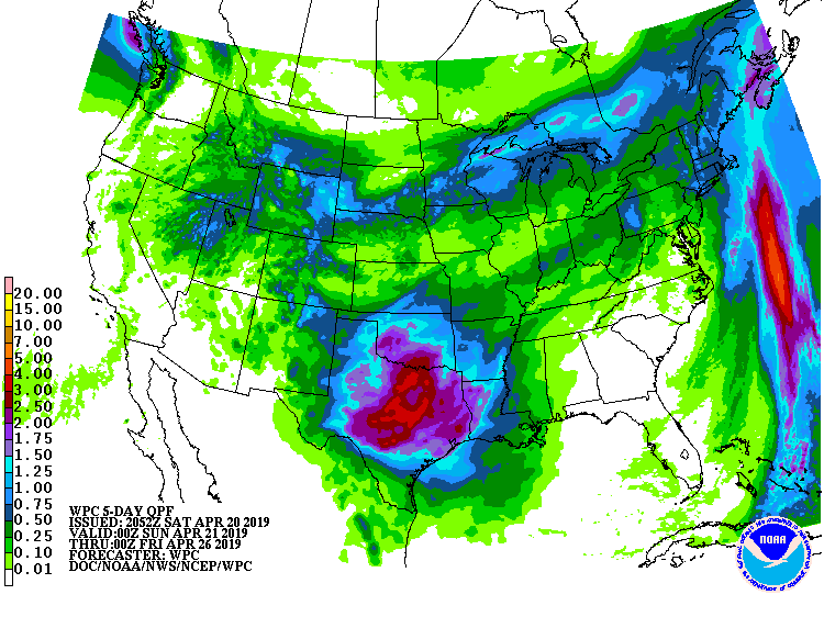
00z Euro shows 3-5" across DFW over the next week
1 likes
Winter time post are almost exclusively focused on the DFW area.
-
bubba hotep
- S2K Supporter
- Posts: 6014
- Joined: Wed Dec 28, 2016 1:00 am
- Location: Collin County Texas
Re: Texas Spring 2019
12z GFS also very wet for DFW over the next two weeks.
0 likes
Winter time post are almost exclusively focused on the DFW area.

Re: Texas Spring 2019
bubba hotep wrote:12z GFS also very wet for DFW over the next two weeks.
I’m gonna have to disagree with the placement of all that qpf on the GFS. I think it’ll be spread out over a much larger portion of the state.
1 likes

-
bubba hotep
- S2K Supporter
- Posts: 6014
- Joined: Wed Dec 28, 2016 1:00 am
- Location: Collin County Texas
-
bubba hotep
- S2K Supporter
- Posts: 6014
- Joined: Wed Dec 28, 2016 1:00 am
- Location: Collin County Texas
-
rwfromkansas
- Category 5

- Posts: 3038
- Joined: Sat Aug 27, 2005 12:47 am
- Location: North Fort Worth
-
Haris

- Category 5
- Posts: 1814
- Joined: Mon Nov 27, 2017 8:19 pm
- Location: ( Bee Cave) West Austin, Texas
Re: Texas Spring 2019
Loving the ensembles and 12 euro
1 likes
Weather geek and a storm spotter in West Austin. Not a degreed meteorologist. Big snow fan. Love rain and cold! Despise heat!


Re: Texas Spring 2019
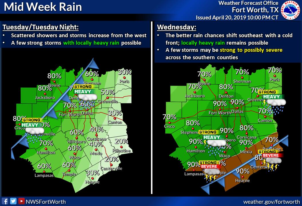
Some excessive rainfall risks locally this week on either side and along I-35 (particularly west side). This will bring most above normal rainfall for April.
2 likes
The above post and any post by Ntxw is NOT an official forecast and should not be used as such. It is just the opinion of the poster and may or may not be backed by sound meteorological data. It is NOT endorsed by any professional institution including Storm2k. For official information, please refer to NWS products.
Help support Storm2K!
Re: Texas Spring 2019
Haris wrote:Loving the ensembles and 12 euro
Yeah not me lol sucks for my area. Models had me getting 3-4” to now maybe .50”
0 likes
-
weatherdude1108
- Category 5
- Posts: 4228
- Joined: Tue Dec 13, 2011 1:04 pm
- Location: Northwest Austin/Cedar Park, TX
Re: Texas Spring 2019
Slight risk for excessive rainfall for central Texas on Wednesday according to the WPC.

Excessive Rainfall Discussion
NWS Weather Prediction Center College Park MD
448 AM EDT Mon Apr 22 2019
Day 3
Valid 12Z Wed Apr 24 2019 - 12Z Thu Apr 25 2019
...THERE IS A SLIGHT RISK FOR EXCESSIVE RAINFALL FOR CENTRAL AND
NORTHERN TEXAS...AND AN ENCOMPASSING MARGINAL RISK FROM EASTERN
NEW MEXICO TO WESTERN MISSOURI AND ARKANSAS...
The frontal progression is expected to slow across central Texas
and Oklahoma while the moisture feeding into this boundary
increases. PW values of 1.75 with impulses of 2 inches will be
streaming into the Southern Plains on Day 3. Strong surface
convergence, strong instability, enhanced lift in the mid/upper
atmosphere will help sustain widespread convection over this
region. The latest model guidance continue to show high confidence
of QPF of 3 to 6+ inches across central/eastern Texas with a few
extending into southwest Oklahoma. High resolution guidance
depicts multiple hours where rainfall rates are 1 to 1.5
inches/per hour. Current 1 hour FFG for much of Texas is 2 to 3
hours, with 3-hourly values of 2 to 4 inches. Based on the setup,
expected QPF and high rainfall rates excessive rainfall will
likely be problematic across central Texas. A Slight Risk was
introduced for the center of the state. Confidence is fairly high
that locations will likely have rainfall exceeding FFG however the
exact placement is still questionable as of this issuance.
Depending on model trends and changing soil saturation with rain
today and on Day 2, portions of central/eastern Texas may need an
upgrade to Moderate Risk for as the threat for flash flooding
rises.
Campbell
1 likes
The preceding post is NOT an official forecast, and should not be used as such. It is only the opinion of the poster and may or may not be backed by sound meteorological data. It is NOT endorsed by any professional institution including storm2k.org. For Official Information please refer to the NHC and NWS products.
-
bubba hotep
- S2K Supporter
- Posts: 6014
- Joined: Wed Dec 28, 2016 1:00 am
- Location: Collin County Texas
Re: Texas Spring 2019
Ntxw wrote:Some excessive rainfall risks locally this week on either side and along I-35 (particularly west side). This will bring most above normal rainfall for April.
DFW is about 1" over for April and near normal for Spring but still down for the year. A blend of the 00z guidance looks like 2-4" for DFW with the possibility of much higher amounts. It will be hard to pin down the jackpot areas in advance with multiple rounds of convection but there could be some big totals out there.
1 likes
Winter time post are almost exclusively focused on the DFW area.
-
Haris
- Category 5
- Posts: 1814
- Joined: Mon Nov 27, 2017 8:19 pm
- Location: ( Bee Cave) West Austin, Texas
Re: Texas Spring 2019
I think the models like the gfs aren’t handling the progression of the front well and we should see higher amounts in Austin. What do y’all think?
1 likes
Weather geek and a storm spotter in West Austin. Not a degreed meteorologist. Big snow fan. Love rain and cold! Despise heat!
-
South Texas Storms

- Professional-Met

- Posts: 4259
- Joined: Thu Jun 24, 2010 12:28 am
- Location: Houston, TX
Re: Texas Spring 2019
Haris wrote:I think the models like the gfs aren’t handling the progression of the front well and we should see higher amounts in Austin. What do y’all think?
Yeah I'm favoring QPF amounts similar to the Euro right now. Fronts usually push farther south than the models indicate, which would lead to higher rainfall amounts across south central Texas.
I don't think the NAM rainfall totals look too bad right now either. Will be interested to see the WRF models as we get closer to the event.
0 likes
-
Haris
- Category 5
- Posts: 1814
- Joined: Mon Nov 27, 2017 8:19 pm
- Location: ( Bee Cave) West Austin, Texas
Re: Texas Spring 2019
Wow. The new ECM is coming 100% different from GFS. wooo 
1 likes
Weather geek and a storm spotter in West Austin. Not a degreed meteorologist. Big snow fan. Love rain and cold! Despise heat!
-
weatherdude1108
- Category 5
- Posts: 4228
- Joined: Tue Dec 13, 2011 1:04 pm
- Location: Northwest Austin/Cedar Park, TX
Re: Texas Spring 2019
On the local weather, they were comparing two different models, and they were pretty similar.


1 likes
The preceding post is NOT an official forecast, and should not be used as such. It is only the opinion of the poster and may or may not be backed by sound meteorological data. It is NOT endorsed by any professional institution including storm2k.org. For Official Information please refer to the NHC and NWS products.
-
weatherdude1108
- Category 5
- Posts: 4228
- Joined: Tue Dec 13, 2011 1:04 pm
- Location: Northwest Austin/Cedar Park, TX
Re: Texas Spring 2019
Excessive Rainfall Discussion
NWS Weather Prediction Center College Park MD
319 PM EDT Mon Apr 22 2019
Day 3
Valid 12Z Wed Apr 24 2019 - 12Z Thu Apr 25 2019
...THERE IS A SLIGHT RISK FOR EXCESSIVE RAINFALL FOR CENTRAL AND
NORTHERN TEXAS AND FAR SOUTHERN OKLAHOMA...
The frontal progression, as discussed in the Day 2 ERD, will
continue to trek across central Texas and Oklahoma. Precipitable
water values of 1.5 to 1.75 will advect into the Southern Plains,
which is on the order of 1.5 to nearly 2 standard deviations above
the mean, aided by 25 to 35 southerly low level flow. Strong
surface convergence, instability (noted by surface based CAPE
>2000 J/kg) and enhanced lift in the mid/upper atmosphere will
help sustain widespread convection over this region. The latest
model guidance continues to show high confidence of QPF of 3 to 5+
inches across central/eastern Texas into far southwest Oklahoma.
High resolution guidance depicts multiple hours where rainfall
rates are 1 to 1.5 inches/per hour associated with convective
activity. Current 1 hour FFG for much of Texas is 2 to 3 hours,
with 3-hourly values of 2 to 4 inches. Based on the expected
setup, anticipate QPF and high rainfall rates will likely be
problematic across central Texas. After careful coordination, a
Slight Risk was maintained and refined for central TX into far
southern Oklahoma. Confidence is fairly high that some locations
will exceed FFG, however, the exact placement of the front and
thus the heaviest QPF axis is still unknown as of this issuance.
Depending on model trends and changing soil saturation from rains
expected late today and on Day 2, portions of central Texas will
likely need to be upgrade to a Moderate Risk as the threat for
flash flooding rises.
Campbell/Pagano
Last edited by weatherdude1108 on Mon Apr 22, 2019 3:18 pm, edited 1 time in total.
1 likes
The preceding post is NOT an official forecast, and should not be used as such. It is only the opinion of the poster and may or may not be backed by sound meteorological data. It is NOT endorsed by any professional institution including storm2k.org. For Official Information please refer to the NHC and NWS products.
Re: Texas Spring 2019
I hope you central Texas folks can get some good rain. Not too excited about this event here in southeast TX. Looks like less than an inch for us.
1 likes
-
TheProfessor

- Professional-Met
- Posts: 3506
- Age: 29
- Joined: Tue Dec 03, 2013 10:56 am
- Location: Wichita, Kansas
Re: Texas Spring 2019
I hope you guys enjoy your rain. After tomorrow if finally looks like I'll go a week without >50% of rain. Just gotta remember to bring my umbrella on a day with 30% rain because if not I'll be in that 30% area who sees rain lol. 
1 likes
An alumnus of The Ohio State University.
Your local National Weather Service office is your best source for weather information.
Your local National Weather Service office is your best source for weather information.
Return to “USA & Caribbean Weather”
Who is online
Users browsing this forum: No registered users and 131 guests