Cpv17 wrote:Austin folks are going to like today’s 12z Euro
Ummmm not really lol. That would be a disaster and we will have to boil water for another 2 weeks just like Oct. lol. Hopefully we can get those totals in a slightly longer period of time.
Moderator: S2k Moderators


Cpv17 wrote:Austin folks are going to like today’s 12z Euro
Haris wrote:Cpv17 wrote:Austin folks are going to like today’s 12z Euro
Ummmm not really lol. That would be a disaster and we will have to boil water for another 2 weeks just like Oct. lol. Hopefully we can get those totals in a slightly longer period of time.

Ntxw wrote:Cpv17 wrote:So when’s our next rainmaker? Looks like this one is pretty much over for my area.
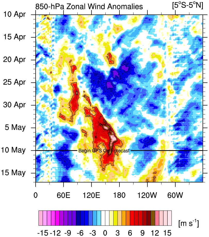
Third or fourth week of May. Winds will reverse near 120W from easterly to westerly signaling an EPAC awakening. Invest or depression of some sort and plume associated will feed Texas. All models are showing a major block over Hudson Bay (west -NAO) that will bring a major trough from GOA -> Southwest that will be the feature to draw up moisture from the deep Pacific tropics.
https://images2.imgbox.com/85/dc/G4iEfxRc_o.gif
It is a classic Spring flooding type pattern. The fact that the water basins are at capacity is pre-conditioning for major flood.
https://images2.imgbox.com/e6/10/29YarGkd_o.jpg
https://images2.imgbox.com/be/0f/n8h9ZLsE_o.jpg
1900hurricane wrote:Ntxw wrote:Cpv17 wrote:So when’s our next rainmaker? Looks like this one is pretty much over for my area.
Third or fourth week of May. Winds will reverse near 120W from easterly to westerly signaling an EPAC awakening. Invest or depression of some sort and plume associated will feed Texas. All models are showing a major block over Hudson Bay (west -NAO) that will bring a major trough from GOA -> Southwest that will be the feature to draw up moisture from the deep Pacific tropics.
https://images2.imgbox.com/85/dc/G4iEfxRc_o.gif
It is a classic Spring flooding type pattern. The fact that the water basins are at capacity is pre-conditioning for major flood.
https://images2.imgbox.com/e6/10/29YarGkd_o.jpg
https://images2.imgbox.com/be/0f/n8h9ZLsE_o.jpg
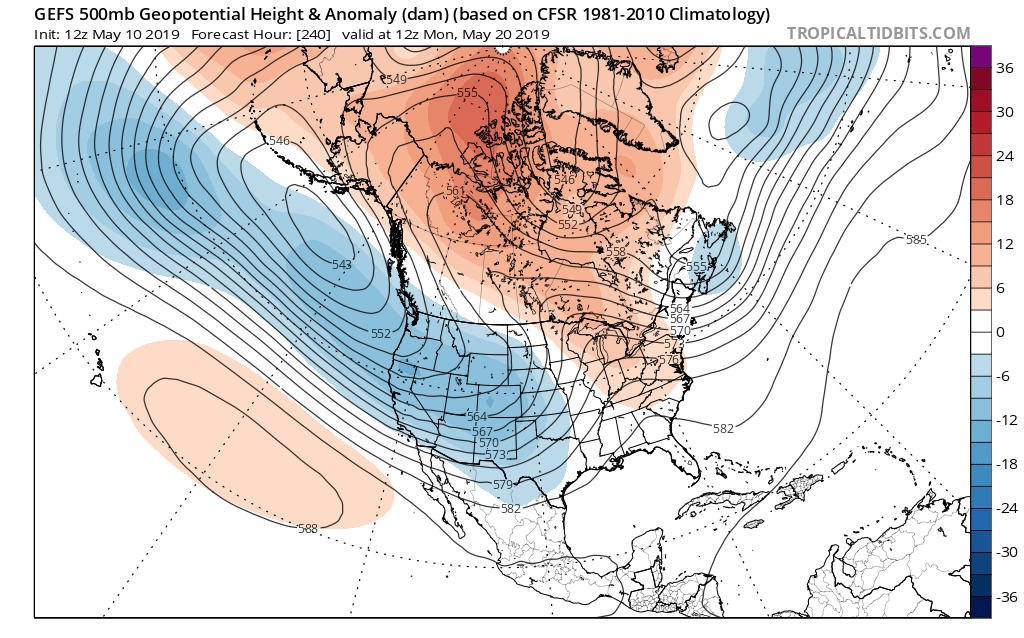
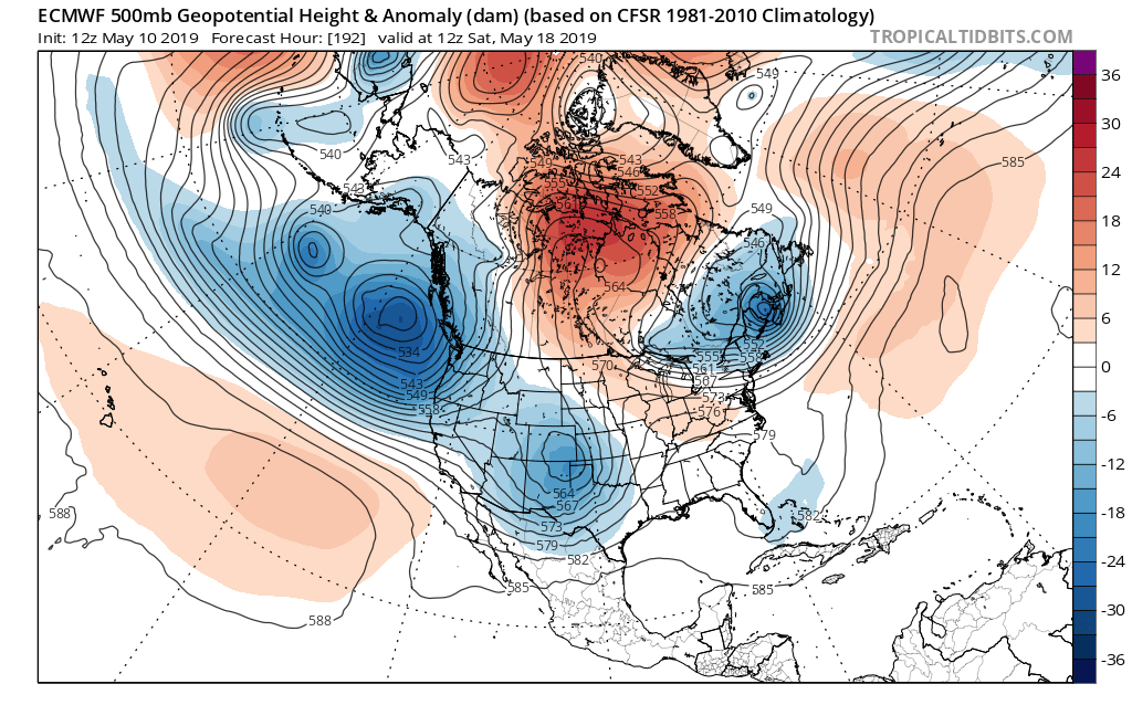
That GEFS mean is a work of art. Just in time for the start of my my chase trip too!

TexasF6 wrote:A foot or so of rain in Travis & Williamson Counties I-35 corridor would be devastating. Euro is bouncing the area of greatest rainfall around in the subsequent runs. A very interesting but not yet disturbing trend.
Cpv17 wrote:1900hurricane wrote:Ntxw wrote:
Third or fourth week of May. Winds will reverse near 120W from easterly to westerly signaling an EPAC awakening. Invest or depression of some sort and plume associated will feed Texas. All models are showing a major block over Hudson Bay (west -NAO) that will bring a major trough from GOA -> Southwest that will be the feature to draw up moisture from the deep Pacific tropics.
https://images2.imgbox.com/85/dc/G4iEfxRc_o.gif
It is a classic Spring flooding type pattern. The fact that the water basins are at capacity is pre-conditioning for major flood.
https://images2.imgbox.com/e6/10/29YarGkd_o.jpg
https://images2.imgbox.com/be/0f/n8h9ZLsE_o.jpg
That GEFS mean is a work of art. Just in time for the start of my my chase trip too!
What’s it showing?
1900hurricane wrote:Cpv17 wrote:1900hurricane wrote:That GEFS mean is a work of art. Just in time for the start of my my chase trip too!
What’s it showing?
https://twitter.com/ahberrington/status/1127639071797534720

HockeyTx82 wrote:What does all this mean? When, where and how rare of a setup is this........

Cpv17 wrote:HockeyTx82 wrote:What does all this mean? When, where and how rare of a setup is this........
Look at the placement of that trough over the west and the raging jet stream. Spells trouble over the southern plains.
Lagreeneyes03 wrote:Cpv17 wrote:HockeyTx82 wrote:What does all this mean? When, where and how rare of a setup is this........
Look at the placement of that trough over the west and the raging jet stream. Spells trouble over the southern plains.
Severe for DFW?


HockeyTx82 wrote:So in the Winter don't trust long range, in Spring take them as Gospel?
So someone Tweets long range model outputs and people go with it?
I trust SPC but even then the caveat is subject to change.
This site is the closest I get to social media in any form.
HockeyTx82 wrote:So in the Winter don't trust long range, in Spring take them as Gospel?
So someone Tweets long range model outputs and people go with it?
I trust SPC but even then the caveat is subject to change.
This site is the closest I get to social media in any form.
dhweather wrote:HockeyTx82 wrote:So in the Winter don't trust long range, in Spring take them as Gospel?
So someone Tweets long range model outputs and people go with it?
I trust SPC but even then the caveat is subject to change.
This site is the closest I get to social media in any form.
It's really hard to get the ingredients for WInter Weather this far south, so that leads to understandable skepticism in the winter.
It's really easy to get the ingredients for severe weather this far south, leading to increased belief in the models, within reason. > 5 days out, trust none of them. They may give you a general idea of what may happen and the overall pattern, but not the fine details.


Return to “USA & Caribbean Weather”
Users browsing this forum: AnnularCane, Greener, Ntxw, SnowyOwl31, wxman22 and 174 guests


