ATL: DORIAN - Models

Moderator: S2k Moderators

Message
Author
caneseddy
Category 5
Category 5
Posts: 1172
Joined: Fri Sep 03, 2004 9:31 pm
Location: Plantation, FL

Re: ATL: DORIAN - Models

#1281 Postby caneseddy » Tue Aug 27, 2019 11:38 pm

MrJames wrote:CMC is east on this run and slower. Heading WNW toward West Palm Beach but the ridge looks like its starting to erode at 108hr.


Landfall over West Palm Beach moving due west over Lake Okeechobee..shift south
0 likes   

User avatar
toad strangler
S2K Supporter
S2K Supporter
Posts: 4543
Joined: Sun Jul 28, 2013 3:09 pm
Location: Earth
Contact:

Re: ATL: DORIAN - Models

#1282 Postby toad strangler » Tue Aug 27, 2019 11:39 pm

CMC landfalls in Martin County, FL it looks like. Don’t hold your breath
0 likes   

User avatar
SouthFloridawx
S2K Supporter
S2K Supporter
Posts: 8346
Age: 46
Joined: Tue Jul 26, 2005 1:16 am
Location: Sarasota, FL
Contact:

Re: ATL: DORIAN - Models

#1283 Postby SouthFloridawx » Tue Aug 27, 2019 11:39 pm

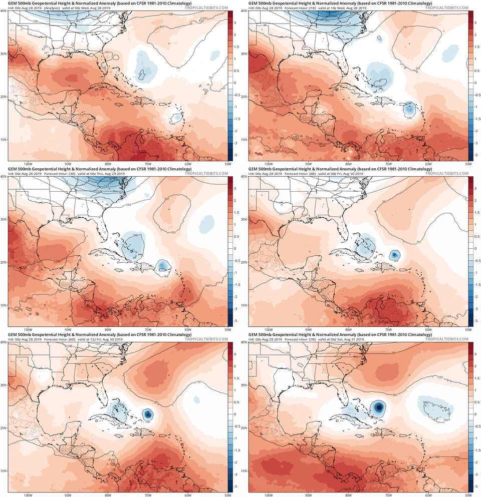
So, I think I figured something out. Please just follow/bear with me for a minute. There is a mid to upper level low/feature to the NW of Dorian and South of Erin.
Image
If you look at the models in the short term through 60 hours, Erin isn't as much of a factor as the mid/upper level low I've pointed out above.
Run the lops and you'll see the feature moving. With the GFS and the Legacy is move slowly to the west, helping to keep the ridge broken down. With CMC and ICON it moves more quickly to the west allowing for the ridge to build in faster.
GFS: https://www.tropicaltidbits.com/analysis/models/?model=gfs&region=watl&pkg=z500aNorm&runtime=2019082800&fh=6
GFS: Legacy: https://www.tropicaltidbits.com/analysis/models/?model=gfs-legacy&region=watl&pkg=z500aNorm&runtime=2019082800&fh=12
CMC: https://www.tropicaltidbits.com/analysis/models/?model=gem&region=watl&pkg=z500aNorm&runtime=2019082800&fh=12
ICON: https://www.tropicaltidbits.com/analysis/models/?model=icon&region=watl&pkg=z500_vort&runtime=2019082800&fh=12

I'm going to watch and see if the other models pick up on this. I think it may be something additional to watch in the short term.
1 likes   

User avatar
AdamFirst
S2K Supporter
S2K Supporter
Posts: 2491
Age: 36
Joined: Thu Aug 14, 2008 10:54 am
Location: Port Saint Lucie, FL

Re: ATL: DORIAN - Models

#1284 Postby AdamFirst » Tue Aug 27, 2019 11:40 pm

HWRF is running. Showing an intensifying storm in the short term on approach to Puerto Rico.
2 likes   
Dolphins Marlins Canes Golden Panthers HEAT
Andrew 1992 - Irene 1999 - Frances 2004 - Jeanne 2004 - Wilma 2005 - Fay 2008 - Isaac 2012 - Matthew 2016 - Irma 2017 - Dorian 2019 - Ian 2022 - Nicole 2022 - Milton 2024

MrJames
Tropical Storm
Tropical Storm
Posts: 189
Joined: Fri Sep 10, 2004 11:56 am
Location: Jax, FL

Re: ATL: DORIAN - Models

#1285 Postby MrJames » Tue Aug 27, 2019 11:43 pm

CMC is not a fan of Florida...

Image
0 likes   

LarryWx
S2K Supporter
S2K Supporter
Posts: 6319
Joined: Sun Sep 07, 2003 2:04 pm
Location: GA

Re: ATL: DORIAN - Models

#1286 Postby LarryWx » Tue Aug 27, 2019 11:43 pm

Steve wrote:Larry,

UK last couple seasons has had an E bias as much as it has had a west. It shows a SW hook. We'll see Saturday or Sunday if it was right.


Steve, It may end up right like it was for Irma but I distinctly recall it being too far left/west quite a bit more often than the reverse over the last few years when it is on the left side of the guidance envelope. Apparently the reason is too much ridging being assumed to its north. That being said, the CMC is also left for now. So, we’ll see.
1 likes   
Personal Forecast Disclaimer:
The posts in this forum are NOT official forecasts and should not be used as such. They are just the opinion of the poster and may or may not be backed by sound meteorological data. They are NOT endorsed by any professional institution or storm2k.org. For official information, please refer to the NHC and NWS products.

User avatar
AdamFirst
S2K Supporter
S2K Supporter
Posts: 2491
Age: 36
Joined: Thu Aug 14, 2008 10:54 am
Location: Port Saint Lucie, FL

Re: ATL: DORIAN - Models

#1287 Postby AdamFirst » Tue Aug 27, 2019 11:43 pm

CMC run is almost identical to Jeanne's track in a way. Begins to curve toward the NW over the state, not quite getting to the Gulf and slowing down considerably, setting up rain event for the northern half of the state.
0 likes   
Dolphins Marlins Canes Golden Panthers HEAT
Andrew 1992 - Irene 1999 - Frances 2004 - Jeanne 2004 - Wilma 2005 - Fay 2008 - Isaac 2012 - Matthew 2016 - Irma 2017 - Dorian 2019 - Ian 2022 - Nicole 2022 - Milton 2024

User avatar
AubreyStorm
Category 1
Category 1
Posts: 337
Age: 44
Joined: Fri Jun 16, 2017 6:21 pm
Location: Texas, USA

Re: ATL: DORIAN - Models

#1288 Postby AubreyStorm » Tue Aug 27, 2019 11:45 pm

AdamFirst wrote:HWRF is running. Showing an intensifying storm in the short term on approach to Puerto Rico.


Please link...... :eek:
0 likes   
The posts are NOT an official forecast. Please REFER to the NHC and NWS for official forecasts and products.

User avatar
sponger
S2K Supporter
S2K Supporter
Posts: 1620
Joined: Thu Jul 22, 2004 11:26 am
Location: St Augustine

Re: ATL: DORIAN - Models

#1289 Postby sponger » Tue Aug 27, 2019 11:46 pm

AdamFirst wrote:CMC run is almost identical to Jeanne's track in a way. Begins to curve toward the NW over the state, not quite getting to the Gulf and slowing down considerably, setting up rain event for the northern half of the state.


That was ugly for Saint augustine. The entire 3 day Labor Day weekend was spent getting blasted by the dirty side of the storm. Then off to work with no power for a week. Brutal.
Last edited by sponger on Wed Aug 28, 2019 12:01 am, edited 1 time in total.
0 likes   
The following post is NOT an official forecast and should not be used as such. It is just the opinion of the poster and may or may not be backed by sound meteorological data. It is NOT endorsed by any professional institution including storm2k.org For Official Information please refer to the NHC and NWS products.

User avatar
AtlanticWind
S2K Supporter
S2K Supporter
Posts: 1890
Age: 66
Joined: Sun Aug 08, 2004 9:57 pm
Location: Plantation,Fla

Re: ATL: DORIAN - Models

#1290 Postby AtlanticWind » Tue Aug 27, 2019 11:47 pm

Its hard to trust the models too much at 120+hours on this storm

Yesterday they had this interacting with Hispanola and now it looks like
it may clip the east side of Puerto Rico .
2 likes   

User avatar
AdamFirst
S2K Supporter
S2K Supporter
Posts: 2491
Age: 36
Joined: Thu Aug 14, 2008 10:54 am
Location: Port Saint Lucie, FL

Re: ATL: DORIAN - Models

#1291 Postby AdamFirst » Tue Aug 27, 2019 11:48 pm

For what it's worth, the very end of the ICON run has a 'cane heading toward the Mississippi Gulf Coast (beyond 170hr~).

AubreyStorm wrote:
AdamFirst wrote:HWRF is running. Showing an intensifying storm in the short term on approach to Puerto Rico.


Please link...... :eek:


https://www.tropicaltidbits.com/analysi ... 2800&fh=21

Island weakens it a bit but the core looks intact. Strengthening again as it departs the island.
2 likes   
Dolphins Marlins Canes Golden Panthers HEAT
Andrew 1992 - Irene 1999 - Frances 2004 - Jeanne 2004 - Wilma 2005 - Fay 2008 - Isaac 2012 - Matthew 2016 - Irma 2017 - Dorian 2019 - Ian 2022 - Nicole 2022 - Milton 2024

User avatar
SouthFloridawx
S2K Supporter
S2K Supporter
Posts: 8346
Age: 46
Joined: Tue Jul 26, 2005 1:16 am
Location: Sarasota, FL
Contact:

Re: ATL: DORIAN - Models

#1292 Postby SouthFloridawx » Tue Aug 27, 2019 11:53 pm

Here's a GIF that mid/upper level feature I'm talking about.
Image
Last edited by SouthFloridawx on Tue Aug 27, 2019 11:53 pm, edited 1 time in total.
0 likes   

User avatar
StPeteMike
Category 2
Category 2
Posts: 631
Joined: Thu Jun 07, 2018 11:26 pm

Re: ATL: DORIAN - Models

#1293 Postby StPeteMike » Tue Aug 27, 2019 11:54 pm

SouthFloridawx

I’m probably bonkers here and going to watch the massive low pressure system near Nova Scotia. If it dips down far enough in the Northern Atlantic, before shooting back north between Greenland and the U.K., it might push the ridge further south and west. Possibly might cause that ULL to cut off from Erin and get stuck going west instead of tailing Erin and setting up a weakness for Dorian to recurve.
2 likes   
The above post is not official and should not be used as such. It is the opinion of the poster and may or may not be backed by sound meteorological data. It is not endorsed by any professional institution or storm2k.org. For official information, please refer to the NHC and NWS products.

User avatar
SouthFloridawx
S2K Supporter
S2K Supporter
Posts: 8346
Age: 46
Joined: Tue Jul 26, 2005 1:16 am
Location: Sarasota, FL
Contact:

Re: ATL: DORIAN - Models

#1294 Postby SouthFloridawx » Tue Aug 27, 2019 11:56 pm

Here's the GFS on that mid/upper level low:
Image
0 likes   

User avatar
sponger
S2K Supporter
S2K Supporter
Posts: 1620
Joined: Thu Jul 22, 2004 11:26 am
Location: St Augustine

Re: ATL: DORIAN - Models

#1295 Postby sponger » Tue Aug 27, 2019 11:56 pm

Highteeld wrote:CMC out to hour 90

https://i.imgur.com/JBaKxN6.png


Very strong ridging!
0 likes   
The following post is NOT an official forecast and should not be used as such. It is just the opinion of the poster and may or may not be backed by sound meteorological data. It is NOT endorsed by any professional institution including storm2k.org For Official Information please refer to the NHC and NWS products.

User avatar
SouthFloridawx
S2K Supporter
S2K Supporter
Posts: 8346
Age: 46
Joined: Tue Jul 26, 2005 1:16 am
Location: Sarasota, FL
Contact:

Re: ATL: DORIAN - Models

#1296 Postby SouthFloridawx » Tue Aug 27, 2019 11:58 pm

It's probably both. I mean, it's all linked.
StPeteMike wrote:SouthFloridawx
I’m probably bonkers here and going to watch the massive low pressure system near Nova Scotia. If it dips down far enough in the Northern Atlantic, before shooting back north between Greenland and the U.K., it might push the ridge further south and west. Possibly might cause that ULL to cut off from Erin and get stuck going west instead of tailing Erin and setting up a weakness for Dorian to recurve.
0 likes   

User avatar
Highteeld
Category 5
Category 5
Posts: 2139
Age: 41
Joined: Tue Jan 30, 2018 9:10 pm
Location: Chicago

Re: ATL: DORIAN - Models

#1297 Postby Highteeld » Wed Aug 28, 2019 12:27 am

HMON is bombing out this run

Image
0 likes   
Very useful information on the Dvorak Technique --

https://severe.worldweather.wmo.int/TCF ... kBeven.pdf

User avatar
sponger
S2K Supporter
S2K Supporter
Posts: 1620
Joined: Thu Jul 22, 2004 11:26 am
Location: St Augustine

Re: ATL: DORIAN - Models

#1298 Postby sponger » Wed Aug 28, 2019 12:42 am

Euro is running! Told myself I would not stay up for this.
3 likes   
The following post is NOT an official forecast and should not be used as such. It is just the opinion of the poster and may or may not be backed by sound meteorological data. It is NOT endorsed by any professional institution including storm2k.org For Official Information please refer to the NHC and NWS products.

User avatar
STRiZZY
Category 1
Category 1
Posts: 276
Joined: Fri Aug 05, 2016 6:01 pm
Location: Largo, FL

Re: ATL: DORIAN - Models

#1299 Postby STRiZZY » Wed Aug 28, 2019 12:43 am

sponger wrote:Euro is running! Told myself I would not stay up for this.


Looks to have initialized properly.
0 likes   

USTropics
Professional-Met
Professional-Met
Posts: 2659
Joined: Sun Aug 12, 2007 3:45 am
Location: Florida State University

Re: ATL: DORIAN - Models

#1300 Postby USTropics » Wed Aug 28, 2019 12:50 am

00z GFS ensembles:
Image
1 likes   


Return to “2019”

Who is online

Users browsing this forum: No registered users and 6 guests