ATL: DORIAN - Models
Moderator: S2k Moderators
Re: ATL: DORIAN - Models
supercane4867 wrote:https://i.imgur.com/ebZS97c.png
Interesting low west of Dorian here. Maybe a hint at what's driving some of the models to be faster.
Last edited by BobHarlem on Thu Aug 29, 2019 4:23 pm, edited 1 time in total.
0 likes

Re: ATL: DORIAN - Models
gatorcane wrote:18Z ICON slightly SW of 12Z at 75 hours near Grand Bahama
What is interesting that it is faster than at least 4 previous runs.
it has been king so far with Dorian at 72 hrs forecast.
2 likes
-
AutoPenalti
- Category 5

- Posts: 4091
- Age: 29
- Joined: Mon Aug 17, 2015 4:16 pm
- Location: Ft. Lauderdale, Florida
Re: ATL: DORIAN - Models
ICON has been very consistent with track so far. Kinda surprised.
2 likes
The posts in this forum are NOT official forecasts and should not be used as such. They are just the opinion of the poster and may or may not be backed by sound meteorological data. They are NOT endorsed by any professional institution or STORM2K. For official information, please refer to products from the NHC and NWS.
Model Runs Cheat Sheet:
GFS (5:30 AM/PM, 11:30 AM/PM)
HWRF, GFDL, UKMET, NAVGEM (6:30-8:00 AM/PM, 12:30-2:00 AM/PM)
ECMWF (1:45 AM/PM)
TCVN is a weighted averaged
Re: ATL: DORIAN - Models
1 likes
Re: ATL: DORIAN - Models
gatorcane wrote:18Z ICON. Looks like Broward/Palm Beach line
https://i.postimg.cc/52c0nYFR/icon-mslp-pcpn-frzn-seus-30.png
Yes. But on a slight WSW heading so bad news for Broward and Dade. Not that such tiny details matter this far out.
0 likes
-
gatorcane

- S2K Supporter

- Posts: 23708
- Age: 48
- Joined: Sun Mar 13, 2005 3:54 pm
- Location: Boca Raton, FL
Re: ATL: DORIAN - Models
ICON has been consistent run after run after run. Hope it ends up consistently wrong. That would be devastating and to a highly populated area. I think you have to go back to 1947 when this happened last?
1 likes
Re: ATL: DORIAN - Models
AutoPenalti wrote:ICON has been very consistent with track so far. Kinda surprised.
ICON did fairly well with Barry.
2 likes
-
tolakram
- Admin

- Posts: 20186
- Age: 62
- Joined: Sun Aug 27, 2006 8:23 pm
- Location: Florence, KY (name is Mark)
Re: ATL: DORIAN - Models
Don't look now but the Ukie is doing well all the way to 120 hours.


source: http://www.atmos.albany.edu/facstaff/tang/tcguidance/al052019/
source: http://www.atmos.albany.edu/facstaff/tang/tcguidance/al052019/
4 likes
M a r k
- - - - -
Join us in chat: Storm2K Chatroom Invite. Android and IOS apps also available.
The posts in this forum are NOT official forecasts and should not be used as such. Posts are NOT endorsed by any professional institution or STORM2K.org. For official information and forecasts, please refer to NHC and NWS products.
-
beachman80
Re: ATL: DORIAN - Models
Well for someone who lives in Tampa Bay, I hope the ICON track is wrong. That thing is drifting NW right off the west coast.
0 likes
-
Aric Dunn
- Category 5
- Posts: 21238
- Age: 43
- Joined: Sun Sep 19, 2004 9:58 pm
- Location: Ready for the Chase.
- Contact:
Re: ATL: DORIAN - Models
Also dont forget ridge pumping which models are terrible at forecasting. The angle Dorian will be interacting with the ridge is a good setup for ridge pumping.
1 likes
Note: If I make a post that is brief. Please refer back to previous posts for the analysis or reasoning. I do not re-write/qoute what my initial post said each time.
If there is nothing before... then just ask
Space & Atmospheric Physicist, Embry-Riddle Aeronautical University,
I believe the sky is falling...
If there is nothing before... then just ask
Space & Atmospheric Physicist, Embry-Riddle Aeronautical University,
I believe the sky is falling...
-
gatorcane
- S2K Supporter
- Posts: 23708
- Age: 48
- Joined: Sun Mar 13, 2005 3:54 pm
- Location: Boca Raton, FL
Re: ATL: DORIAN - Models
Aric Dunn wrote:Also dont forget ridge pumping which models are terrible at forecasting. The angle Dorian will be interacting with the ridge is a good setup for ridge pumping.
Agreed last not forget Irma. 72 hours out and the GFS and Euro seemed locked in on SE Florida. Then run after run we watched the models shift west even just 24 to 36 hours out. I almost would feel better if the track was over me now. A lot of shifting can happen even in the short-range.
2 likes
-
Storm Battered
- Tropical Low

- Posts: 24
- Joined: Mon Jun 11, 2018 12:15 pm
Re: ATL: DORIAN - Models
Hypercane_Kyle wrote:I do agree with the user (I'm sorry, I forgot who) who pointed out that hurricanes very rarely take that sharp of a turn so quickly. ECMWF shows Dorian almost doing a complete 180 from drifting WSW to going NNW in ~12 hours. That's breakneck for a hurricane. Usually the track looks up being more rounded and smooth looking.
Maybe it was Blinhart?
Blinhart wrote:
If I would have to answer that question, I would say the likelihood is very low of a sharp turn like that happening. I think it would take more like 36 hours not 18 hours.
Agreed. Models rarely pick up on or show jogs. Depicting a sharp turn in such a short time is odd.
0 likes
-
FLpanhandle91

- Category 5
- Posts: 1039
- Age: 34
- Joined: Mon Sep 13, 2010 3:50 pm
- Location: Fort Walton Beach, FL
Re: ATL: DORIAN - Models
18z GFS about the same as 12z through 24 hours. Maybe just a tiny bit stronger ridging.
0 likes
-
gatorcane
- S2K Supporter
- Posts: 23708
- Age: 48
- Joined: Sun Mar 13, 2005 3:54 pm
- Location: Boca Raton, FL
Re: ATL: DORIAN - Models
18Z GFS rolling. Ridge already looks slightly stronger out through 24 hours.
0 likes
-
jasons2k

- Storm2k Executive
- Posts: 8290
- Age: 52
- Joined: Wed Jul 06, 2005 12:32 pm
- Location: The Woodlands, TX
Re: ATL: DORIAN - Models
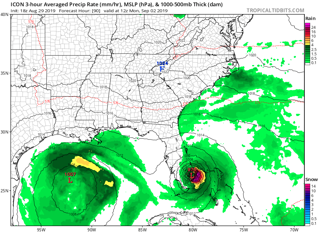
gatorcane wrote:18Z ICON. Looks like Broward/Palm Beach line
Umm - what is that in the Gulf and where did it come from? Wondering if that could have an influence on Dorian as well by creating a weakness to its west.
0 likes
-
FLpanhandle91
- Category 5
- Posts: 1039
- Age: 34
- Joined: Mon Sep 13, 2010 3:50 pm
- Location: Fort Walton Beach, FL
Re: ATL: DORIAN - Models
Dorian slightly stronger through 42 hours and about 40 miles northeast.
0 likes
-
gatorcane
- S2K Supporter
- Posts: 23708
- Age: 48
- Joined: Sun Mar 13, 2005 3:54 pm
- Location: Boca Raton, FL
Re: ATL: DORIAN - Models
At 48 hours GFS has a more WSW to ENE oriented ridge. That is what the Euro has been insisting.
0 likes


Re: ATL: DORIAN - Models
jasons wrote:gatorcane wrote:18Z ICON. Looks like Broward/Palm Beach line
https://i.postimg.cc/52c0nYFR/icon-mslp-pcpn-frzn-seus-30.png
Umm - what is that in the Gulf and where did it come from? Wondering if that could have an influence on Dorian as well by creating a weakness to its west.
It’s been in various models for days. It’s the forerunning upper low that seems to get a surface signature down the road. This has been on some of the runs since Sunday or Monday.
Here’s the Icon @ 500mb
https://www.tropicaltidbits.com/analysi ... 918&fh=120
Last edited by Steve on Thu Aug 29, 2019 4:51 pm, edited 1 time in total.
0 likes
Who is online
Users browsing this forum: No registered users and 10 guests