ATL: DORIAN - Models
Moderator: S2k Moderators
Re: ATL: DORIAN - Models
By far the strongest landfall of the UKmet runs i have seen; about 942 mb in Melbourne
0 likes
Very useful information on the Dvorak Technique --
https://severe.worldweather.wmo.int/TCF ... kBeven.pdf
https://severe.worldweather.wmo.int/TCF ... kBeven.pdf
Re: ATL: DORIAN - Models
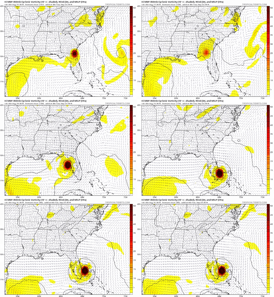
Last 5 00z Euro runs


Last edited by b0tzy29 on Fri Aug 30, 2019 12:32 pm, edited 2 times in total.
1 likes
Re: ATL: DORIAN - Models
So GOM is starting to look less likely, but still possible?
0 likes
Storm Track: Erin '95, Opal '95, Danny '97, Georges '98, Ivan '04, Dennis '05
Re: ATL: DORIAN - Models
HMON runs it just offshore up the coast, quite similar to the 12z ECM last night that moved it WSW then sharp northwards.
0 likes
Personal Forecast Disclaimer:
The posts in this forum are NOT official forecast and should not be used as such. They are just the opinion of the poster and may or may not be backed by sound meteorological data. They are NOT endorsed by any professional institution or storm2k.org. For official information, please refer to the NHC and NWS products
The posts in this forum are NOT official forecast and should not be used as such. They are just the opinion of the poster and may or may not be backed by sound meteorological data. They are NOT endorsed by any professional institution or storm2k.org. For official information, please refer to the NHC and NWS products
Re: ATL: DORIAN - Models
MacTavish wrote:Because of the angle of approach, the landfall location is going to be difficult until the last 24 hours. The models are for the most part in fairly strong agreement as to the basic idea. They will probably change a bit from run to run, and even their combined average may change between now and landfall. The NHC has been pretty consistent with their track, which is similar to what we see in the models now, and have only made slight adjustments based on the nuances of the guidance packages.
Agreed. The angle of the approach to model-defined landfall point is unprecedented as depicted in the GFS and some of the 12z models. Could happen with a WWNW, W or WNW approach toward Cape Canaveral, but the likelihood is pretty low. I'd bet almost any amount of money that a glancing blow or change of direction at/near landfall would happen. For historical purposes only, It would be a trip (not for my people in Brevard) to get a major hit up that way.
0 likes
- SFLcane
- S2K Supporter

- Posts: 10281
- Age: 48
- Joined: Sat Jun 05, 2010 1:44 pm
- Location: Lake Worth Florida
Re: ATL: DORIAN - Models
12Z hwrf is bit south from from its 06z run


Last edited by SFLcane on Fri Aug 30, 2019 12:34 pm, edited 1 time in total.
0 likes
Re: ATL: DORIAN - Models
chris_fit wrote:https://i.imgur.com/p2bf6pl.png
not one of these members shows it missing CONUS... damn
0 likes
- Jevo
- S2K Supporter

- Posts: 1729
- Age: 47
- Joined: Tue Aug 03, 2004 8:45 pm
- Location: The Flemish Cap
- Contact:
Re: ATL: DORIAN - Models
Aric Dunn wrote:4 pages of people arguing about consensus lol
Can we get back to posting the models please..
Would you say that is the consensus opinion?
haha how's it going Aric? What's your take on the shift
2 likes
Disclaimer: 50% of the time I have no clue of what I am talking about. Chances are I am taking a less than educated guess that sounds good because 10 years ago I stole Mike Watkins book 'The Hurricane and its Impact'. For official information please direct yourself to the NHC and their cadre of weather geniuses.
Re: ATL: DORIAN - Models
Anything past its 72-96 hr forecast is going to be inconsistent. By no means the Euro is that good. But it is fairly good in its 72-96 hour compared to other models in that range, except when Dorian was a weak system and didn't see it strengthening and gaining latitude well before Hispaniola
0 likes
Re: ATL: DORIAN - Models
chris_fit wrote:https://i.imgur.com/p2bf6pl.png
Solid spread. All going to come down to how strong the ridge is and when it begins its northward jog
0 likes
-
AxaltaRacing24
- Category 5

- Posts: 1774
- Age: 25
- Joined: Wed Jul 27, 2016 11:14 am
- Location: Jupiter, FL
Re: ATL: DORIAN - Models
chris_fit wrote:https://i.imgur.com/p2bf6pl.png
Most noticeable detail for me is how not a single ensemble didn’t make landfall. not one
2 likes
Re: ATL: DORIAN - Models
HMON Landfall near Cocoa Beach (6z was Ft. Lauderdale, so huge shift north)


Last edited by BobHarlem on Fri Aug 30, 2019 12:38 pm, edited 1 time in total.
0 likes
Re: ATL: DORIAN - Models
Decent agreement on the 12z ensembles as well for a central Florida hit, pretty close to the GFS/UKMO agreement as well has to be said.
Going to be a close call, any faster and Dorian gets into the gulf, any slower and Dorian may ride the east coast towards the Carolinas.
Going to be a close call, any faster and Dorian gets into the gulf, any slower and Dorian may ride the east coast towards the Carolinas.
0 likes
Personal Forecast Disclaimer:
The posts in this forum are NOT official forecast and should not be used as such. They are just the opinion of the poster and may or may not be backed by sound meteorological data. They are NOT endorsed by any professional institution or storm2k.org. For official information, please refer to the NHC and NWS products
The posts in this forum are NOT official forecast and should not be used as such. They are just the opinion of the poster and may or may not be backed by sound meteorological data. They are NOT endorsed by any professional institution or storm2k.org. For official information, please refer to the NHC and NWS products
Re: ATL: DORIAN - Models
HWRF last few plots through 87 hours are due west about 27.2 +/- Jupiter/Juno Beach, FL. Gotta landfall there on this run, right?
Stuart/Port St. Lucie @ 93 hours so valid 4am Tuesday on the HWRF
Stuart/Port St. Lucie @ 93 hours so valid 4am Tuesday on the HWRF
Last edited by Steve on Fri Aug 30, 2019 12:39 pm, edited 1 time in total.
0 likes
- chris_fit
- Category 5

- Posts: 3261
- Age: 43
- Joined: Wed Sep 10, 2003 11:58 pm
- Location: Tampa Bay Area, FL
Re: ATL: DORIAN - Models
Basically - Melbourne/Cocoa Beach/Cape Canaveral - Don't wanna be there according to many many of the 12Z Models
1 likes
-
Aric Dunn
- Category 5

- Posts: 21238
- Age: 43
- Joined: Sun Sep 19, 2004 9:58 pm
- Location: Ready for the Chase.
- Contact:
Re: ATL: DORIAN - Models
Jevo wrote:Aric Dunn wrote:4 pages of people arguing about consensus lol
Can we get back to posting the models please..
Would you say that is the consensus opinion?
haha how's it going Aric? What's your take on the shift
Lol.. what consensus?
I just want to see the plot of the ukmet. Im not home and nothing is loading on my phone
0 likes
Note: If I make a post that is brief. Please refer back to previous posts for the analysis or reasoning. I do not re-write/qoute what my initial post said each time.
If there is nothing before... then just ask
Space & Atmospheric Physicist, Embry-Riddle Aeronautical University,
I believe the sky is falling...
If there is nothing before... then just ask
Space & Atmospheric Physicist, Embry-Riddle Aeronautical University,
I believe the sky is falling...
Re: ATL: DORIAN - Models
NDG wrote:
Anything past its 72-96 hr forecast is going to be inconsistent. By no means the Euro is that good. But it is fairly good in its 72-96 hour compared to other models in that range, except when Dorian was a weak system and didn't see it strengthening and gaining latitude well before Hispaniola
Yes of course... but definitely has moved more east over time
0 likes
- petit_bois
- Tropical Storm

- Posts: 227
- Joined: Tue Jun 22, 2010 12:04 pm
- Location: Petit Bois Island Mississippi
Re: ATL: DORIAN - Models
Jonny wrote:So GOM is starting to look less likely, but still possible?
14 yrs ago the Katrina models were looking VERY similar to these... remarkable similar.
I'm not going to be surprised on Sunday when the consensus points to the big bend area and then only to be pointing to MS coast on Monday.
All these models have struggled with verifying out beyond 18hrs with this storm... watch the chaos when it loses its steering current.
JMHO
1 likes
Resident of the Atlantic Basin's Major Hurricane Hit Capital!
Camille (200+winds), Frederic, Goerges, Katrina... and many many more.
Disclaimer: I'm likely the smartest guy here... but I have no idea where a tropical cyclone will go. I suggest you take my opinion as a grain of salt. I suggest you look to the National Hurricane Center for accurate info.
Camille (200+winds), Frederic, Goerges, Katrina... and many many more.
Disclaimer: I'm likely the smartest guy here... but I have no idea where a tropical cyclone will go. I suggest you take my opinion as a grain of salt. I suggest you look to the National Hurricane Center for accurate info.
Who is online
Users browsing this forum: No registered users and 23 guests


