
i’ve been on here lurking in the shadows for a few years now and I’ve noticed a trend over those years with the models. During the daytime runs they typically shift to the east and in the overnight or evening runs things tend to shift back to the west. Why is this? Everyone calls this the windshield wiper effect but if you look at when this effect is happening it regularly falls into daytime/west. nighttime/west
Thank you in advance.
ATL: DORIAN - Post-Tropical - Discussion
Moderator: S2k Moderators

Re: ATL: DORIAN - Hurricane - Discussion
Hammy wrote:ozonepete wrote:rickybobby wrote:
Looks like Florida won’t get hit
Please don't do that without saying it's an amateur's opinion. A lot of people on here might take you seriously and of course you don't want that responsibility, right?
I make a lot of predictions (half of which end up wrong) and have kept the disclaimer in my sig for that reason.
A sig is not permission to say whatever you want on these forums, especially the way you did which makes you sound certain that it's going to recurve OTS.
It's dangerous and this isn't the time nor the place for that.
1 likes

Re: ATL: DORIAN - Hurricane - Discussion
CryHavoc wrote:Hammy wrote:ozonepete wrote:
Please don't do that without saying it's an amateur's opinion. A lot of people on here might take you seriously and of course you don't want that responsibility, right?
I make a lot of predictions (half of which end up wrong
A sig is not permission to say whatever you want on these forums, especially the way you did which makes you sound certain that it's going to recurve OTS.
It's dangerous and this isn't the time nor the place for that.
The sig is there so that users can make their own forecasts based on data and not be mistaken for official forecasts.
5 likes
The above post is not official and should not be used as such. It is the opinion of the poster and may or may not be backed by sound meteorological data. It is not endorsed by any professional institution or storm2k.org. For official information, please refer to the NHC and NWS products.
-
otowntiger
- Category 5

- Posts: 1932
- Joined: Tue Aug 31, 2004 7:06 pm
Re: ATL: DORIAN - Hurricane - Discussion
ozonepete wrote:This is really ramping up. CIMSS ADT is probably not wrong about it approaching Cat 4. I've been thinking all along tht it's not likely it wil make a Cat 5 since they are so rare but from the looks of this and the very favorble conditions now I'm beginning to think it has a pretty good shot at Cat 5. This is just going to be horrible where it makes landfall.
IF it makes landfall, right?
0 likes

Re: ATL: DORIAN - Hurricane - Discussion
Back are the days of infinite EWRC declarations, calls for RI and wobble watching.
What a subculture we have.
What a subculture we have.
4 likes
Re: ATL: DORIAN - Hurricane - Discussion
Aric Dunn wrote:Looks like another ERC is starting.. some evidence of inner convection firing and an outer ring of convection.. hard to say but sure looks like it ..
So how big would the eye be when that happens? I guess we will see when recon eventually gets there.
1 likes
Re: ATL: DORIAN - Hurricane - Discussion
rickybobby wrote:AxaltaRacing24 wrote:Airboy wrote:Looks to me it have pretty much stalled for on hour, or at least not moving much
A sign that the turn is imminent.
Looks like Florida won’t get hit
Why would you say that? Literally turning toward Florida
0 likes
Re: ATL: DORIAN - Hurricane - Discussion
bjm519209 wrote:i’ve been on here lurking in the shadows for a few years now and I’ve noticed a trend over those years with the models. During the daytime runs they typically shift to the east and in the overnight or evening runs things tend to shift back to the west. Why is this? Everyone calls this the windshield wiper effect but if you look at when this effect is happening it regularly falls into daytime/west. nighttime/west
Thank you in advance.
I personally have not witnessed this. Models shift all the time. Unless you have several examples to provide, it makes it hard to really evaluate what you're saying.
Hurricanes do tend to gain more strength at night than during the day (as the diurnal heating of the ocean makes the water slightly warmer at night, especially in the early hours of nightfall), but that doesn't necessarily correspond to a shift in track.
1 likes
-
La Sirena

- Category 1

- Posts: 308
- Joined: Sun Aug 21, 2016 4:02 pm
- Location: Formerly of the Keys, back home in East TN
Re: ATL: DORIAN - Hurricane - Discussion
Hammy wrote:CryHavoc wrote:Hammy wrote:
I make a lot of predictions (half of which end up wrong
A sig is not permission to say whatever you want on these forums, especially the way you did which makes you sound certain that it's going to recurve OTS.
It's dangerous and this isn't the time nor the place for that.
The sig is there so that users can make their own forecasts based on data and not be mistaken for official forecasts.
While somewhat true, I still think that those who are just checking the board for the first time (and are likely worried or panicked) don’t even see or truly process the disclaimer. It’s probably just easiest to not post the predictions as fact.
7 likes
The posts in this forum are NOT official forecasts and should not be used as such. They are just the opinion of the poster and may or may not be backed by sound meteorological data. They are NOT endorsed by any professional institution or STORM2K. For official information, please refer to products from the NHC and NWS.
Hurricane Irma,Hurricane Michael, Hurricane Helene
-
AutoPenalti
- Category 5
- Posts: 4091
- Age: 29
- Joined: Mon Aug 17, 2015 4:16 pm
- Location: Ft. Lauderdale, Florida
Re: ATL: DORIAN - Hurricane - Discussion
rickybobby wrote:Wesh 2’s Tony said he expects the cone to move to the east by maybe 50 miles at the 5pm update. There’s hope the it will recurve and not hit any land and that chance is increasing.
Seriously, this Wesh 2 stuff needs to stop. NHC are not going to shift an entire cone over one run. They do not model hug and for him to expect stuff like this just seems wrong.
7 likes
The posts in this forum are NOT official forecasts and should not be used as such. They are just the opinion of the poster and may or may not be backed by sound meteorological data. They are NOT endorsed by any professional institution or STORM2K. For official information, please refer to products from the NHC and NWS.
Model Runs Cheat Sheet:
GFS (5:30 AM/PM, 11:30 AM/PM)
HWRF, GFDL, UKMET, NAVGEM (6:30-8:00 AM/PM, 12:30-2:00 AM/PM)
ECMWF (1:45 AM/PM)
TCVN is a weighted averaged


Re: ATL: DORIAN - Hurricane - Discussion
ozonepete wrote:rickybobby wrote:AxaltaRacing24 wrote:A sign that the turn is imminent.
Looks like Florida won’t get hit
Please don't do that without saying it's an amateur's opinion. A lot of people on here might take you seriously and of course you don't want that responsibility, right?
The Euro has flipped so many time with this. Coast, offshore, eastern coastal, right peninsula on shore
I think there are more flips to come.
4 likes
Re: ATL: DORIAN - Hurricane - Discussion
Buck wrote:Back are the days of infinite EWRC declarations, calls for RI and wobble watching.
What a subculture we have.
A rare de-lurking to say, "The song remains the same..."
3 likes
-
jlauderdal
- S2K Supporter

- Posts: 7240
- Joined: Wed May 19, 2004 5:46 am
- Location: NE Fort Lauderdale
- Contact:
Re: RE: Re: ATL: DORIAN - Hurricane - Discussion
A 50 mile track adjustment to the east doesn't seemunreasonable, the cone moves in tandem with track as its pure statisticsAutoPenalti wrote:rickybobby wrote:Wesh 2’s Tony said he expects the cone to move to the east by maybe 50 miles at the 5pm update. There’s hope the it will recurve and not hit any land and that chance is increasing.
Seriously, this Wesh 2 stuff needs to stop. NHC are not going to shift an entire cone over one run. They do not model hug and for him to expect stuff like this just seems wrong.
0 likes
-
TheDreamTraveler

- Category 2

- Posts: 645
- Joined: Sun Aug 22, 2010 3:10 am
- Location: PA
-
Aric Dunn
- Category 5
- Posts: 21238
- Age: 43
- Joined: Sun Sep 19, 2004 9:58 pm
- Location: Ready for the Chase.
- Contact:
Re: ATL: DORIAN - Hurricane - Discussion
AutoPenalti wrote:rickybobby wrote:Wesh 2’s Tony said he expects the cone to move to the east by maybe 50 miles at the 5pm update. There’s hope the it will recurve and not hit any land and that chance is increasing.
Seriously, this Wesh 2 stuff needs to stop. NHC are not going to shift an entire cone over one run. They do not model hug and for him to expect stuff like this just seems wrong.
we have seen them throw the euro out on occasion over the years.
2 likes
Note: If I make a post that is brief. Please refer back to previous posts for the analysis or reasoning. I do not re-write/qoute what my initial post said each time.
If there is nothing before... then just ask
Space & Atmospheric Physicist, Embry-Riddle Aeronautical University,
I believe the sky is falling...
If there is nothing before... then just ask
Space & Atmospheric Physicist, Embry-Riddle Aeronautical University,
I believe the sky is falling...
-
AxaltaRacing24
- Category 5
- Posts: 1774
- Age: 25
- Joined: Wed Jul 27, 2016 11:14 am
- Location: Jupiter, FL
Re: ATL: DORIAN - Hurricane - Discussion
MetroMike wrote:ozonepete wrote:rickybobby wrote:
Looks like Florida won’t get hit
Please don't do that without saying it's an amateur's opinion. A lot of people on here might take you seriously and of course you don't want that responsibility, right?
The Euro has flipped so many time with this. Coast, offshore, eastern coastal, right peninsula on shore
I think there are more flips to come.
I expect more swings as well.
1 likes
Re: ATL: DORIAN - Hurricane - Discussion
Hammy wrote:CryHavoc wrote:Hammy wrote:
I make a lot of predictions (half of which end up wrong
A sig is not permission to say whatever you want on these forums, especially the way you did which makes you sound certain that it's going to recurve OTS.
It's dangerous and this isn't the time nor the place for that.
The sig is there so that users can make their own forecasts based on data and not be mistaken for official forecasts.
People coming to this board who are potentially ~100 hours away from losing their homes may not have the time or presence of mind to read your sig. Furthermore, it may not even show up on the page at all, depending on the settings people assign to their profile.
All I'm asking is that we refrain from making statements that sound like certainty when we're 4 days out from a potential major hurricane landfall. We know people come here for guidance and advice, and IMO (and according to many admins that I've seen post on this matter) means we do have a reasonable expectation of not posting pure speculation like it's ironclad fact.
10 likes
-
AutoPenalti
- Category 5
- Posts: 4091
- Age: 29
- Joined: Mon Aug 17, 2015 4:16 pm
- Location: Ft. Lauderdale, Florida
Re: RE: Re: ATL: DORIAN - Hurricane - Discussion
jlauderdal wrote:A 50 mile track adjustment to the east doesn't seemunreasonable, the cone moves in tandem with track as its pure statisticsAutoPenalti wrote:rickybobby wrote:Wesh 2’s Tony said he expects the cone to move to the east by maybe 50 miles at the 5pm update. There’s hope the it will recurve and not hit any land and that chance is increasing.
Seriously, this Wesh 2 stuff needs to stop. NHC are not going to shift an entire cone over one run. They do not model hug and for him to expect stuff like this just seems wrong.
Not over one model run.
2 likes
The posts in this forum are NOT official forecasts and should not be used as such. They are just the opinion of the poster and may or may not be backed by sound meteorological data. They are NOT endorsed by any professional institution or STORM2K. For official information, please refer to products from the NHC and NWS.
Model Runs Cheat Sheet:
GFS (5:30 AM/PM, 11:30 AM/PM)
HWRF, GFDL, UKMET, NAVGEM (6:30-8:00 AM/PM, 12:30-2:00 AM/PM)
ECMWF (1:45 AM/PM)
TCVN is a weighted averaged
Re: ATL: DORIAN - Hurricane - Discussion
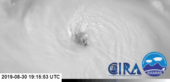
What a stunning storm. To think this has potentially 96 more hours over water...
7 likes
-
drewschmaltz
- S2K Supporter
- Posts: 351
- Joined: Thu Aug 27, 2015 8:19 pm
Re: ATL: DORIAN - Hurricane - Discussion
I think we can now say with a fair amount of certainty that this will be somewhere between the keys and out to sea. That's the boundary of the trends from what I can tell. From what I understand data is backwards fed into the models based on movement to retroactively match the path (is this true?) and if true, the certainty goes up dramatically once Dorian begins interacting with the features that will ultimately determine landfall.
2 likes
I HAVE ABSOLUTELY NO IDEA WHAT I'M TALKING ABOUT. PLEASE CONSULT SOMEONE WHO DOES. START WITH THE NHC. ALL POSTS ARE FOR ENTERTAINMENT PURPOSES ONLY.
Who is online
Users browsing this forum: No registered users and 30 guests