ATL: DORIAN - Models
Moderator: S2k Moderators
-
gatorcane

- S2K Supporter

- Posts: 23708
- Age: 48
- Joined: Sun Mar 13, 2005 3:54 pm
- Location: Boca Raton, FL
Re: ATL: DORIAN - Models
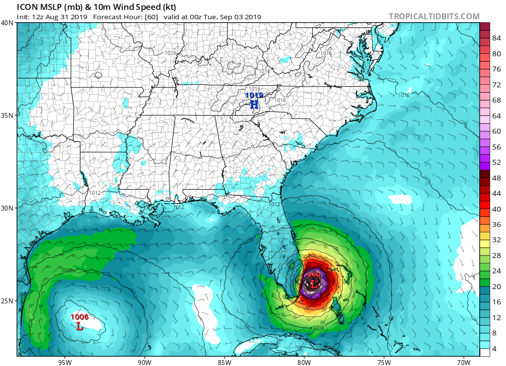
Stalling over the Gulf Stream battering SE Florida:
Last edited by gatorcane on Sat Aug 31, 2019 10:12 am, edited 1 time in total.
0 likes
-
GeneratorPower

- S2K Supporter
- Posts: 1648
- Age: 46
- Joined: Sun Dec 18, 2005 11:48 pm
- Location: Huntsville, AL
Re: ATL: DORIAN - Models
I have not seen any solid explanation of the ICON (Intensity Consensus) model and its reliability for track.
2 likes
-
HurricaneFrances04
- Category 2

- Posts: 597
- Joined: Mon Jun 25, 2012 8:09 am
- Location: Fort Lauderdale, Florida
Re: ATL: DORIAN - Models
GeneratorPower wrote:I have not seen any solid explanation of the ICON (Intensity Consensus) model and its reliability for track.
They are separate models.
0 likes
-
SouthDadeFish

- Professional-Met

- Posts: 2835
- Joined: Thu Sep 23, 2010 2:54 pm
- Location: Miami, FL
- Contact:
Re: ATL: DORIAN - Models
GeneratorPower wrote:I have not seen any solid explanation of the ICON (Intensity Consensus) model and it’s reliability for track.
They are not the same model. It's confusing, I know. The ICON being referenced here is a global model: https://www.dwd.de/EN/research/weatherforecasting/num_modelling/01_num_weather_prediction_modells/icon_description.html
It is not the same as the ICON intensity consensus model.
1 likes

Re: ATL: DORIAN - Models
GeneratorPower wrote:I have not seen any solid explanation of the ICON (Intensity Consensus) model and its reliability for track.
not the Intensity Consensus, it is the new German Model, totally different than the one that the NHC states in their discussions.
0 likes
Personal Forecast Disclaimer:
The posts in this forum are NOT official forecast and should not be used as such. They are just the opinion of the poster and may or may not be backed by sound meteorological data. They are NOT endorsed by any professional institution or storm2k.org. For official information, please refer to the NHC and NWS products.
The posts in this forum are NOT official forecast and should not be used as such. They are just the opinion of the poster and may or may not be backed by sound meteorological data. They are NOT endorsed by any professional institution or storm2k.org. For official information, please refer to the NHC and NWS products.

Re: ATL: DORIAN - Models
If this ICON run is any indicator of how the rest of today's runs will trend, things could get spicy real quick
2 likes
-
SFLcane

- S2K Supporter
- Posts: 10281
- Age: 48
- Joined: Sat Jun 05, 2010 1:44 pm
- Location: Lake Worth Florida
Re: ATL: DORIAN - Models
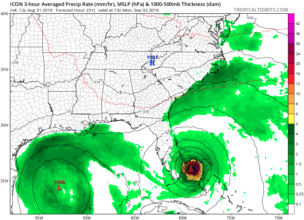
gatorcane wrote:Wow ICON back to the SW turn now at 51 hours
https://i.postimg.cc/YCrQRzwy/icon-mslp-pcpn-seus-17.png
Hopefully not a trend with the other models
0 likes
-
gatorcane
- S2K Supporter
- Posts: 23708
- Age: 48
- Joined: Sun Mar 13, 2005 3:54 pm
- Location: Boca Raton, FL
Re: ATL: DORIAN - Models
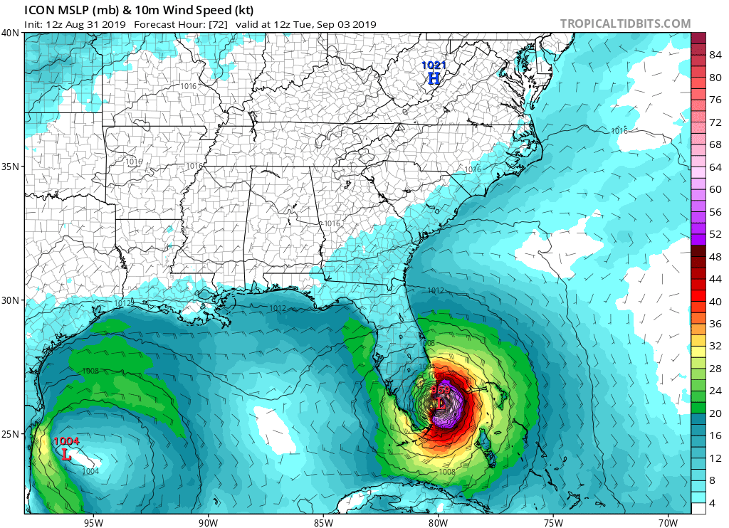
ICON 72 hours turns NNW with landfall Broward County / Ft Lauderdale it looks like:
Last edited by gatorcane on Sat Aug 31, 2019 10:19 am, edited 1 time in total.
0 likes
-
AutoPenalti
- Category 5

- Posts: 4091
- Age: 29
- Joined: Mon Aug 17, 2015 4:16 pm
- Location: Ft. Lauderdale, Florida
Re: ATL: DORIAN - Models
ICON has landfall in Broward.
0 likes
The posts in this forum are NOT official forecasts and should not be used as such. They are just the opinion of the poster and may or may not be backed by sound meteorological data. They are NOT endorsed by any professional institution or STORM2K. For official information, please refer to products from the NHC and NWS.
Model Runs Cheat Sheet:
GFS (5:30 AM/PM, 11:30 AM/PM)
HWRF, GFDL, UKMET, NAVGEM (6:30-8:00 AM/PM, 12:30-2:00 AM/PM)
ECMWF (1:45 AM/PM)
TCVN is a weighted averaged
-
Blown Away

- S2K Supporter
- Posts: 10253
- Joined: Wed May 26, 2004 6:17 am
Re: ATL: DORIAN - Models

12z ICON has direct landfall into SE Florida vs a brush/recurve for 06z...
0 likes
Hurricane Eye Experience: David 79, Irene 99, Frances 04, Jeanne 04, Wilma 05… Hurricane Brush Experience: Andrew 92, Erin 95, Floyd 99, Matthew 16, Irma 17, Ian 22, Nicole 22…

Re: ATL: DORIAN - Models
NHC recognizes the precarious situation with the stall and some ensemble members still pointing to Florida. Think they meant Euro and UKMET ensembles in the discussion.
Most of the global models shift the high eastward and deepens a trough over the
eastern United States beyond 2 days. This steering flow would
typically favor a gradual turn of the hurricane to the northwest and
north, however there is large uncertainty in the exact location
and timing of this northward turn. Although the latest guidance
has shifted a little bit eastward again this morning, there are
still ECMWF and GFS ensemble members that do not forecast the
northward turn so soon. On this basis, NHC prefers to shift the
track forecast just a little bit to the right of the previous one,
and the new official forecast lies along the western edge of the
guidance envelope. This will allow for further adjustments in the
track during future forecast cycles.
3 likes

Re: ATL: DORIAN - Models
SouthDadeFish wrote:GeneratorPower wrote:I have not seen any solid explanation of the ICON (Intensity Consensus) model and it’s reliability for track.
They are not the same model. It's confusing, I know. The ICON being referenced here is a global model: https://www.dwd.de/EN/research/weatherforecasting/num_modelling/01_num_weather_prediction_modells/icon_description.html
It is not the same as the ICON intensity consensus model.
Do you know if this model ran with the additional recon data from the turnaround late plane run that other models (EURO, GFS) I heard missed loading before they ran the most current runs?
1 likes

Re: ATL: DORIAN - Models
Dorian will have to start moving on a 300 degree heading like right now for it to meet the forecasted point at 0z this evening by the 06z HWRF.
Dorian has been tracking on a 280 degree angle this morning over all.
Dorian has been tracking on a 280 degree angle this morning over all.
1 likes

Re: ATL: DORIAN - Models
ICON has been the furtherest south of any model, but it has been very reluctant to buy this further north and OTS idea that the models have been suggesting.
Thus far, its been doing a better job than most models with the very short term track it has to be said, but long ways to go yet.
Thus far, its been doing a better job than most models with the very short term track it has to be said, but long ways to go yet.
7 likes
Personal Forecast Disclaimer:
The posts in this forum are NOT official forecast and should not be used as such. They are just the opinion of the poster and may or may not be backed by sound meteorological data. They are NOT endorsed by any professional institution or storm2k.org. For official information, please refer to the NHC and NWS products
The posts in this forum are NOT official forecast and should not be used as such. They are just the opinion of the poster and may or may not be backed by sound meteorological data. They are NOT endorsed by any professional institution or storm2k.org. For official information, please refer to the NHC and NWS products
Re: ATL: DORIAN - Models
Blown Away wrote:https://i.imgur.com/9h6w2EZ.gif
12z ICON has direct landfall into SE Florida vs a brush/recurve for 06z...
I would like more info on this ICON model.....how long has it been around, and does it have a track record? Seems to be running almost antithetical to other models.
And I haven't seen a one of them yet that seems to really have a handle on things.
1 likes
Cleo - 1964, Betsy - 1965, David - 1979, Andrew - 1992, Charlie (Francis, Ivan, Jeanne) - 2004, Irma - 2017, Ian - 2022, Milton - 2024
Re: ATL: DORIAN - Models
NDG wrote:Dorian will have to start moving on a 300 degree heading like right now for it to meet the forecasted point at 0z this evening by the 06z HWRF.
Dorian has been tracking on a 280 degree angle this morning over all.
Yeah both HWRF and the GFS looked too far north earlier and so this is appearing to be.
I wonder whether the lack of data from the area where the upper ridge is, is really highlighting the overly progressive nature of the GFs/CMC suite in particular in the short term. I know ECM does turn it as well, but it is from a point further south.
2 likes
Personal Forecast Disclaimer:
The posts in this forum are NOT official forecast and should not be used as such. They are just the opinion of the poster and may or may not be backed by sound meteorological data. They are NOT endorsed by any professional institution or storm2k.org. For official information, please refer to the NHC and NWS products
The posts in this forum are NOT official forecast and should not be used as such. They are just the opinion of the poster and may or may not be backed by sound meteorological data. They are NOT endorsed by any professional institution or storm2k.org. For official information, please refer to the NHC and NWS products
Re: ATL: DORIAN - Models
Does anyone have any thoughts about the indicated pressure (991 mb) @ t=0 on this 12z ICON run and how that may be affecting things?
0 likes
-
jlauderdal
- S2K Supporter
- Posts: 7240
- Joined: Wed May 19, 2004 5:46 am
- Location: NE Fort Lauderdale
- Contact:
Re: RE: Re: ATL: DORIAN - Models
https://twitter.com/SheliNBC6/status/1167814125428387840gatorcane wrote:ICON 72 hours turns NNW with landfall Broward County / Ft Lauderdale it looks like:
0 likes
-
dukeblue219
- S2K Supporter
- Posts: 556
- Joined: Fri Sep 30, 2016 3:52 pm
Re: ATL: DORIAN - Models
kunosoura wrote:Does anyone have any thoughts about the indicated pressure (991 mb) @ t=0 on this 12z ICON run and how that may be affecting things?
The globals usually don't have the exact characteristics of the storms core modelled. That's part of the reason we have "hurricane" models and mesoscale models.
1 likes
Who is online
Users browsing this forum: No registered users and 55 guests