
feederband wrote:We in Highland city just put under Tropical storm watch..
Assume that would mean the same for Bartow.. Let's see what happens
Moderator: S2k Moderators
feederband wrote:We in Highland city just put under Tropical storm watch..


northjaxpro wrote:Pressure if I am seeinh correct now down to 910 mb right?
hohnywx wrote:wxman57 wrote:hohnywx wrote:
Hasn’t it been moving at 8 mph for the past 12+ hours?
It has been gradually slowing down, as predicted. The big slowdown is tonight.
I went back and looked at the NHC advisories. It has been moving west at 8 MPH since 11 AM yesterday. Now, at the 11 AM advisory, it has slowed to 7 MPH.

supercane4867 wrote:Nearing landfall...
https://uploads.disquscdn.com/images/69f3ee62561f26c963d7bf2a0c3ee3f50d1c04605278ff69f7374565fc444762.gif
eastcoastFL wrote:cheezyWXguy wrote:Buck wrote:
Not correct (yet) by any metric. Only for the northwestern Bahamas.
Pretty sure this is in reference to the record set by Irma in regard to hurricanes outside of the Caribbean and Gulf of Mexico, which it set with 180 mph winds and a 914mb central pressure.
You’re correct. That’s what the weather channel just said.

jfk08c wrote:feederband wrote:We in Highland city just put under Tropical storm watch..
Assume that would mean the same for Bartow.. Let's see what happens
supercane4867 wrote:Highest ever SFMR measurement in the modern history of Atlantic Ocean
https://i.imgur.com/lXCleAg.png


Highteeld wrote:This is the super typhoon haiyan of the Atlantic
emings wrote:The Labor Day hurricane from 1935 also had 185mph winds


skillz305 wrote:Did TWC just mention that the cone for 11am isnt updated on visual ???


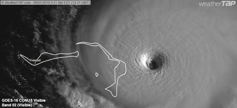
Bostonriff wrote:Anyone have a link to Bahamas radar? TIA....

tiger_deF wrote:Yellow Evan wrote:CrazyC83 wrote:
I'd want to see flight level winds much higher before going into uncharted waters like that. At this rate, who knows, maybe it will close off a CDG ring and end up like Haiyan or Patricia?
https://i.imgur.com/B5PKyDR.jpg
This doesn't even have a W ring... Eye temps could easily rival Patricia though.
It's worth pointing out that farther North tropical systems tend to have trouble producing cloud tops as cold as in the deep tropics, and Dvorak estimates tend to be underdone as hurricanes can be stronger with warmer cloud tops

Users browsing this forum: No registered users and 15 guests


