Texas Fall 2019

U.S. & Caribbean Weather Discussions and Severe Weather Events

Moderator: S2k Moderators

Forum rules

The posts in this forum are NOT official forecast and should not be used as such. They are just the opinion of the poster and may or may not be backed by sound meteorological data. They are NOT endorsed by any professional institution or STORM2K.

Help Support Storm2K
Message
Author
Ralph's Weather
S2K Supporter
S2K Supporter
Posts: 3269
Age: 38
Joined: Fri Dec 13, 2013 11:55 am
Location: Lindale, TX
Contact:

Re: Texas Fall 2019

#401 Postby Ralph's Weather » Thu Sep 26, 2019 11:00 pm

Brent wrote:
BrokenGlass wrote:
Brent wrote:
yeah I'll be honest I haven't hated September really, but like its time for things to change now

I was looking at my weather station data earlier today - for the ENTIRE MONTH of September, it has been below 70 for about 2 1/2 hours, early morning on Sep 1.


Sent from my iPhone using Tapatalk Pro


yeah I don't think DFW even went below 70 all month, crazy, more like summer than September... most Septembers have gone below 60 at least once :double:

Heck we went below 60 back in July.
0 likes   
Follow on Facebook at Ralph's Weather.

Brent
S2K Supporter
S2K Supporter
Posts: 38088
Age: 36
Joined: Sun May 16, 2004 10:30 pm
Location: Tulsa Oklahoma
Contact:

Re: Texas Fall 2019

#402 Postby Brent » Fri Sep 27, 2019 2:05 am

the only good news on the 0z Euro is Dallas doesn't hit 100 but yikes :double: :double:
0 likes   
#neversummer

User avatar
CaptinCrunch
S2K Supporter
S2K Supporter
Posts: 8728
Age: 57
Joined: Mon Nov 03, 2003 4:33 pm
Location: Kennedale, TX (Tarrant Co.)

Re: Texas Fall 2019

#403 Postby CaptinCrunch » Fri Sep 27, 2019 8:10 am

:(

Unfortunately, the slight glimmer of hope of relief from the heat
by the Thursday/Friday continues to fade. Most of the latest model
guidance continues to trend on the warmer end of the spectrum,
with afternoon high temperatures on Thursday in the low to mid
90s. The latest GFS attempts to push the cold front through the
region on Thursday allowing temperatures to cool and bring us
much needed rainfall. However, the ECMWF and ensembles trend
toward a warmer and drier solution with the cold front remaining
northwest of the region and only limited rain chances across the
northwest as riding remains in place.


You might as well start looking toward the middle of October for cooler temps.. The only positive is the coming end of Hurricane season, I think by mid to late October the Ridge of DEATH will finally start to weaken enough to move out and allow for at least 1 month of possible Fall.
0 likes   

weatherdude1108
Category 5
Category 5
Posts: 4228
Joined: Tue Dec 13, 2011 1:04 pm
Location: Northwest Austin/Cedar Park, TX

Re: Texas Fall 2019

#404 Postby weatherdude1108 » Fri Sep 27, 2019 8:19 am

We can't buy a single drop of rain here, in the midst of a flash drought and no end in sight, but only 5 hours up the road, the LBB office is talking about unsettled weather and thunderstorms. :roll: I'm gunna have to go on a road trip to find exciting, wet and COOLER weather, 'cause it ain't gettin' here anytime soon.smh. I have no faith in any models anymore. They can't figure out cold fronts.


778
FXUS64 KLUB 270859
AFDLUB

Area Forecast Discussion
National Weather Service Lubbock TX
359 AM CDT Fri Sep 27 2019

.DISCUSSION...
All is quiet on the weather front early this morning, but this will
be changing as the pattern trends toward another unsettled period.

Before that happens, we`ll have to deal with another hot late
September afternoon. Increasing southwesterly flow will help scour
the moisture further east than we`ve seen lately, as the dryline
pushes off the Caprock this afternoon. Full insolation combined with
downslope breezes will propel highs into the lower and middle 90s
for the South Plains, while the southeast Texas Panhandle and
Rolling Plains will see middle and upper 90s. Certainly no feel of
fall as temperatures peak around 15 degrees above average. Where the
dryline halts it will probably remain capped this afternoon.
However, the retreating dryline will encounter increasing upper
level support tonight as a mid-level wave (formerly the upper low
that has been hanging out over the Desert Southwest the past
several days) approaches. In response, scattered convection should
develop across southeast New Mexico and Far West Texas this
evening, then spread northeastward across the South Plains late
this evening into early Saturday morning. It does appear the
storms should generally be delayed late enough to allow Friday
Night Lights to proceed unimpeded. We have broken down the evening
PoP/Wx grids into 3 hour increments to better reflect the
expected timing of the storm chances. There will be enough
instability (1000-1500 J/kg of CAPE) and 0-6 km wind shear (around
30 knots) that a couple of these late-night elevated storms could
become strong to marginally severe.

Some of the overnight convection could linger into Saturday morning,
though a decreasing trend is expected as the upper level disturbance
quickly lifts off to the north and east. By this time, a large
closed low will be settling into the Intermountain West while a
subtropical ridge begins to amplify across the southeastern states.
This will place West Texas squarely between, where we will
experience a prolonged period of unsettled southwesterly flow
aloft. This pattern, coupled with increasingly rich moisture, will
fuel additional thunderstorm chances along with a threat of heavy
rainfall through much of the rest of the forecast.

Initially, the highest thunderstorm chances will favor the western
counties (into eastern New Mexico), nearest the surface trough and
dryline Saturday afternoon through Sunday. Moderate instability and
wind shear could support a few stronger storms each
afternoon/evening, and there will be enough moisture for locally
heavy downpours. The deep-layer moisture should peak late Monday
into Tuesday (perhaps lingering into Wednesday) as tropical moisture
is funneled northward from the eastern Pacific. This will boost
PWATs to AOA 1.5 inches, which could support a threat of more
widespread heavy rain somewhere in the region. At this point, NWP
favors eastern New Mexico into the western Texas Panhandle Monday
into Tuesday morning. The best fetch of moisture and higher rain
chances should eventually bend eastward later Tuesday or Wednesday
as the western trough ejects over the northern/central High Plains.
Given the expected moist environment, we have maintained the heavy
rain mention in the grids Monday night through Wednesday.

Additionally, we`ll have to see if a cold front associated with the
trough moving by to our north can make it to our latitude. The 00Z
GFS and Canadian do sweep the front through late Wednesday or early
Thursday, while the ECMWF drops the front into the South Plains
Thursday, before quickly lifting it back northward as the western
trough reloads. Regardless, increasing cloud cover and periods of
precipitation will cause high temperatures to trend downward this
weekend into early next week, though lows will remain mild as the
abundant moisture holds firm. Eventually, temperatures may fall
below average if the cold front indeed does manage to make it
through. Even so, the thrust of next week`s front will be toward
the Great Lakes, with only a glancing shot felt here.
0 likes   
The preceding post is NOT an official forecast, and should not be used as such. It is only the opinion of the poster and may or may not be backed by sound meteorological data. It is NOT endorsed by any professional institution including storm2k.org. For Official Information please refer to the NHC and NWS products.

User avatar
Ntxw
Storm2k Moderator
Storm2k Moderator
Posts: 22784
Joined: Wed Oct 21, 2009 6:34 pm
Location: DFW, Texas

Re: Texas Fall 2019

#405 Postby Ntxw » Fri Sep 27, 2019 8:26 am

I know it is unbearable right now as it has been so persistently hot of late but this can be somewhat blamed on the cooling of Nino 1.2 and parts of Nino 3 the past few months. However in a month or two it has the reverse effects as it is beneficial early winter with warmer Nino 4 region.
5 likes   
The above post and any post by Ntxw is NOT an official forecast and should not be used as such. It is just the opinion of the poster and may or may not be backed by sound meteorological data. It is NOT endorsed by any professional institution including Storm2k. For official information, please refer to NWS products.

  Help support Storm2K!
Help Support Storm2K

User avatar
Portastorm
Storm2k Moderator
Storm2k Moderator
Posts: 9914
Age: 63
Joined: Fri Jul 11, 2003 9:16 am
Location: Round Rock, TX
Contact:

Re: Texas Fall 2019

#406 Postby Portastorm » Fri Sep 27, 2019 9:18 am

Ntxw wrote:I know it is unbearable right now as it has been so persistently hot of late but this can be somewhat blamed on the cooling of Nino 1.2 and parts of Nino 3 the past few months. However in a month or two it has the reverse effects as it is beneficial early winter with warmer Nino 4 region.


Funny you should mention this, Ntxw, because I have been privately wondering if there would be some kind of rubberband/snap-back effect in the atmosphere when it eventually changes. If there was any justice in the weather world, we'd be compensated for this horrible, relentless heat with colder and wetter than normal late Fall and all Winter. Well, a fella can hope, right?! :wink:
5 likes   
Any forecasts under my name are to be taken with a grain of salt. Get your best forecasts from the National Weather Service and National Hurricane Center.

weatherdude1108
Category 5
Category 5
Posts: 4228
Joined: Tue Dec 13, 2011 1:04 pm
Location: Northwest Austin/Cedar Park, TX

Re: Texas Fall 2019

#407 Postby weatherdude1108 » Fri Sep 27, 2019 9:42 am

Portastorm wrote:
Ntxw wrote:I know it is unbearable right now as it has been so persistently hot of late but this can be somewhat blamed on the cooling of Nino 1.2 and parts of Nino 3 the past few months. However in a month or two it has the reverse effects as it is beneficial early winter with warmer Nino 4 region.


Funny you should mention this, Ntxw, because I have been privately wondering if there would be some kind of rubberband/snap-back effect in the atmosphere when it eventually changes. If there was any justice in the weather world, we'd be compensated for this horrible, relentless heat with colder and wetter than normal late Fall and all Winter. Well, a fella can hope, right?! :wink:


That does make some sense. Wouldn't there be some lag time in the atmosphere to "catch up" to the cooling of the said Nino areas?

But at the same time, it seems like the lack of rain and heat ridge happened really abruptly, starting in mid-July for us in Central Texas.

It seems like in years with the El Ninos, there is a lag time of several months before the atmosphere reciprocates the ocean currents, and the feedback loop starts, and the rains come. Maybe comparable to the Summer solstice and hottest temperatures a couple months after that (or through September and mid-October, in this year's case). Just some thoughts. :wink:
0 likes   
The preceding post is NOT an official forecast, and should not be used as such. It is only the opinion of the poster and may or may not be backed by sound meteorological data. It is NOT endorsed by any professional institution including storm2k.org. For Official Information please refer to the NHC and NWS products.

User avatar
CaptinCrunch
S2K Supporter
S2K Supporter
Posts: 8728
Age: 57
Joined: Mon Nov 03, 2003 4:33 pm
Location: Kennedale, TX (Tarrant Co.)

Re: Texas Fall 2019

#408 Postby CaptinCrunch » Fri Sep 27, 2019 11:11 am

I found this to be a very good read and says alot about this stupid ridge and just how much longer it could hang around. Looks like we will be dealing with this damn ridge a couple more weeks before we see any change.
:think: :wall: :break:

https://www.aer.com/science-research/climate-weather/arctic-oscillation/
0 likes   

hamburgerman7070
Category 1
Category 1
Posts: 253
Joined: Sat Dec 02, 2017 7:39 pm
Location: Jonesboro ar

Re: Texas Fall 2019

#409 Postby hamburgerman7070 » Fri Sep 27, 2019 11:47 am

CaptinCrunch wrote:I found this to be a very good read and says alot about this stupid ridge and just how much longer it could hang around. Looks like we will be dealing with this damn ridge a couple more weeks before we see any change.
:think: :wall: :break:

https://www.aer.com/science-research/climate-weather/arctic-oscillation/


Thats Dr. Cohen. He hasnt been that good for a while now imo. He seemed better years ago than recently. Also, does anyone know about the IOD? Just curious
0 likes   

User avatar
Ntxw
Storm2k Moderator
Storm2k Moderator
Posts: 22784
Joined: Wed Oct 21, 2009 6:34 pm
Location: DFW, Texas

Re: Texas Fall 2019

#410 Postby Ntxw » Fri Sep 27, 2019 1:51 pm

weatherdude1108 wrote:
Portastorm wrote:
Ntxw wrote:I know it is unbearable right now as it has been so persistently hot of late but this can be somewhat blamed on the cooling of Nino 1.2 and parts of Nino 3 the past few months. However in a month or two it has the reverse effects as it is beneficial early winter with warmer Nino 4 region.


Funny you should mention this, Ntxw, because I have been privately wondering if there would be some kind of rubberband/snap-back effect in the atmosphere when it eventually changes. If there was any justice in the weather world, we'd be compensated for this horrible, relentless heat with colder and wetter than normal late Fall and all Winter. Well, a fella can hope, right?! :wink:


That does make some sense. Wouldn't there be some lag time in the atmosphere to "catch up" to the cooling of the said Nino areas?

But at the same time, it seems like the lack of rain and heat ridge happened really abruptly, starting in mid-July for us in Central Texas.

It seems like in years with the El Ninos, there is a lag time of several months before the atmosphere reciprocates the ocean currents, and the feedback loop starts, and the rains come. Maybe comparable to the Summer solstice and hottest temperatures a couple months after that (or through September and mid-October, in this year's case). Just some thoughts. :wink:


The NAO/AO couplet was running on average negative up until about the end of July and early August. That then allowed the ridge to meander in and make resident in the southern and eastern US. The two oscillations are reversing course so in due time it will flip. ENSO is a better predictor down the road, the very negative SOI that we have seen in September (monthly means now over -15) correlates well to a cooler/wetter later half of October into December.

In fact, I am willing to make a bet that October will flip entirely from the first week to the last 3 weeks, relative to normals.

We do have to account for the expanding hadley cells in particular from SSTs. The warming Oceans are juxtaposed to our usual relative climo regarding these ridges.
6 likes   
The above post and any post by Ntxw is NOT an official forecast and should not be used as such. It is just the opinion of the poster and may or may not be backed by sound meteorological data. It is NOT endorsed by any professional institution including Storm2k. For official information, please refer to NWS products.


  Help support Storm2K!

Help Support Storm2K


User avatar
bubba hotep
S2K Supporter
S2K Supporter
Posts: 5837
Joined: Wed Dec 28, 2016 1:00 am
Location: Collin County Texas

Re: Texas Fall 2019

#411 Postby bubba hotep » Fri Sep 27, 2019 2:36 pm

If anyone was wondering, 12z Euro shows no rain and highs in the 90s all the way until the end of the run for DFW.
1 likes   
Winter time post are almost exclusively focused on the DFW area.

User avatar
starsfan65
Category 2
Category 2
Posts: 704
Age: 47
Joined: Thu Dec 17, 2015 1:18 pm
Location: Garland,Tx

Re: Texas Fall 2019

#412 Postby starsfan65 » Fri Sep 27, 2019 2:53 pm

bubba hotep wrote:If anyone was wondering, 12z Euro shows no rain and highs in the 90s all the way until the end of the run for DFW.
Oh No!!
0 likes   

User avatar
CaptinCrunch
S2K Supporter
S2K Supporter
Posts: 8728
Age: 57
Joined: Mon Nov 03, 2003 4:33 pm
Location: Kennedale, TX (Tarrant Co.)

Re: Texas Fall 2019

#413 Postby CaptinCrunch » Fri Sep 27, 2019 2:57 pm

bubba hotep wrote:If anyone was wondering, 12z Euro shows no rain and highs in the 90s all the way until the end of the run for DFW.


90's and small % for precip through October 4th. This has become our own little "Groundhog Day" hell (minus Bill Murry) today will just repeat itself another 10 days. As NTXW said, the middle of October will either be the turning point like we saw in 2013, or it won't like we saw in 2012.

I'm not sure, I need to look, but I think 2012/2013 Fall/Winter is the only Sept-Feb period to record an 80F day each month.

**Nope, Fall/Winter 2016/2017 also had at least one 80F day (Sept-Feb)
1 likes   

weatherdude1108
Category 5
Category 5
Posts: 4228
Joined: Tue Dec 13, 2011 1:04 pm
Location: Northwest Austin/Cedar Park, TX

Re: Texas Fall 2019

#414 Postby weatherdude1108 » Fri Sep 27, 2019 4:11 pm

Bob Rose:


Friday, September 27, 2019 4:01 PM

Even though the start of October is just days away, an August-like weather pattern continues across Central and South Texas. With persistent, August-like temperatures in place this month, this September is shaping up to be the warmest on record for most locations across the region. For example, Austin-Camp Mabry's monthly average temperature through Thursday has been 88.0 degrees, which is 7.4 degrees warmer than normal. With just 4 days left in the month, September 2019's average temperature will clearly end up being the warmest on record, as the second warmest average September temperature is 3.6 degrees lower at 84.4 degrees, set back in 2011.

Friday's weather maps showed that familiar, summertime ridge of high pressure stretching from northern Mexico to the Middle Atlantic states, producing widespread warm and humid weather. The ridge will unfortunately continue to be the dominant feature controlling our region's weather for at least another week, meaning more summertime weather ahead.

In the near term, forecasters are monitoring a small trough of low pressure located west of the ridge over Arizona and the Four Corners region. This trough is forecast to track northeast toward the Plains states this weekend. As the trough lifts northeast, it is expected to pull a plume of tropical moisture from the Gulf of Mexico, north into Texas. This plume of moisture is predicted to cause the development of scattered, mainly afternoon and evening rain showers and isolated thunderstorms across the region Saturday and Sunday. The highest probability for rain will be across the coastal plains region, where the chance for rain each day will be near 40-50 percent. Across the Hill Country and Central Texas regions, the probability for rain will be 30-40 percent on both days. For locations that do see rain, totals should generally average between a quarter and a half inch. High temperatures both days will be mostly in the mid and upper 90s, with lower 90s expected towards the coast. Expect a southeast wind at 10-15 mph throughout the weekend.

The chance for rain will decrease as we start the work week as the plume of tropical moisture diminishes. Despite the ridge of high pressure hanging tough across the region, there looks to still be a slight chance for a few isolated rain showers and thunderstorms each afternoon next week. The probability for rain will only be 20 percent. In general, weather conditions will remain mostly sunny and unseasonably warm. Daily high temperatures are predicted to be in the mid and upper 90s across the Hill Country and Central Texas regions and in the lower 90s towards the coast.

Friday's forecast data indicates the persistent ridge of high pressure will finally begin to weaken next weekend. Mostly sunny and warm weather looks to continue with highs mostly in the mid-90s. Several of the forecast solutions indicate a large trough of low pressure will push east out of the western US the following Monday (October 7th). This trough will help push a weak cold front into Texas October 7th-8th. No significant rain is expected with the front. Mostly sunny and not quite as hot temperatures are forecast the week of October 7th. High temperatures are predicted to be mostly in the low to mid 90s, with low temperatures in the upper 60s to low 70s.

The extended-range forecast solutions indicate the days of the persistent, summer-time ridge may be limited. Solutions indicate a much weaker ridge over Texas, with a fairly active jet stream to the north the second through third weeks of October. Hopefully, this is a sign our never-ending summer pattern may finally break.


https://www.lcra.org/water/river-and-we ... ather.aspx
2 likes   
The preceding post is NOT an official forecast, and should not be used as such. It is only the opinion of the poster and may or may not be backed by sound meteorological data. It is NOT endorsed by any professional institution including storm2k.org. For Official Information please refer to the NHC and NWS products.

User avatar
dhweather
S2K Supporter
S2K Supporter
Posts: 6199
Joined: Sat Aug 14, 2004 9:29 pm
Location: Heath, TX
Contact:

Re: Texas Fall 2019

#415 Postby dhweather » Fri Sep 27, 2019 5:44 pm

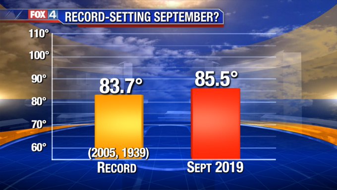
From the FWD AFD this afternoon

RESPECT THE RIDGE OF DEATH !!!!! :lol: :lol: :lol:

Things get slightly more interesting towards the end of next
week, when model solutions begin diverging. A small camp of models
and a few ensembles continue to indicate a breakdown of the
ridge, allowing a weakening front to approach North Texas on
Thursday. While those hoping for the arrival of fall are rooting
for this solution, it is not the most likely scenario. The bulk of
guidance, including an overwhelming number of GEFS members, stall
this front north of the Red River, leaving most of the forecast
area high and dry during the middle/end of next week with the
upper ridge holding steady overhead.
Will continue to side with
warmer/drier guidance, and include only some low PoPs for any
activity that could move southward off a stalled front to our
north late Thursday or Friday. Even if the front does not progress
all the way into the forecast area, at least some increased cloud
cover associated with this system could knock a couple degrees
off of high temperatures to end the week.
0 likes   
The above post and any post by dhweather is NOT an official forecast and should not be used as such. It is just the opinion of the poster and may or may not be backed by sound meteorological data. It is NOT endorsed by any professional institution including storm2k.org. For official information, please refer to NWS products.

Brent
S2K Supporter
S2K Supporter
Posts: 38088
Age: 36
Joined: Sun May 16, 2004 10:30 pm
Location: Tulsa Oklahoma
Contact:

Re: Texas Fall 2019

#416 Postby Brent » Fri Sep 27, 2019 7:12 pm

The entire 18z gfs run is above normal :double:
0 likes   
#neversummer

User avatar
starsfan65
Category 2
Category 2
Posts: 704
Age: 47
Joined: Thu Dec 17, 2015 1:18 pm
Location: Garland,Tx

Re: Texas Fall 2019

#417 Postby starsfan65 » Fri Sep 27, 2019 7:21 pm

Brent wrote:The entire 18z gfs run is above normal :double:

We need to fight this ridge!!
0 likes   

User avatar
bubba hotep
S2K Supporter
S2K Supporter
Posts: 5837
Joined: Wed Dec 28, 2016 1:00 am
Location: Collin County Texas

Re: Texas Fall 2019

#418 Postby bubba hotep » Fri Sep 27, 2019 9:08 pm

Just retarded

Image
2 likes   
Winter time post are almost exclusively focused on the DFW area.

BrokenGlass
Tropical Storm
Tropical Storm
Posts: 192
Joined: Sun Jan 10, 2010 5:36 pm
Location: Richardson, Texas

Re: Texas Fall 2019

#419 Postby BrokenGlass » Fri Sep 27, 2019 9:42 pm

starsfan65 wrote:
Brent wrote:The entire 18z gfs run is above normal :double:

We need to fight this ridge!!

Maybe Trump will nuke the ridge.


Sent from my iPhone using Tapatalk Pro
2 likes   

User avatar
Haris
Category 5
Category 5
Posts: 1810
Joined: Mon Nov 27, 2017 8:19 pm
Location: ( Bee Cave) West Austin, Texas

Re: Texas Fall 2019

#420 Postby Haris » Fri Sep 27, 2019 9:52 pm

Whichever candidate promises me that he or she will nuke all ridges, I'll vote for them.
3 likes   
Weather geek and a storm spotter in West Austin. Not a degreed meteorologist. Big snow fan. Love rain and cold! Despise heat!


Return to “USA & Caribbean Weather”

Who is online

Users browsing this forum: 869MB, South Texas Storms and 9 guests