2019 Tropics: Global Model Runs Discussion (Out to day 16)

This is the general tropical discussion area. Anyone can take their shot at predicting a storms path.

Moderator: S2k Moderators

Forum rules

The posts in this forum are NOT official forecasts and should not be used as such. They are just the opinion of the poster and may or may not be backed by sound meteorological data. They are NOT endorsed by any professional institution or STORM2K. For official information, please refer to products from the National Hurricane Center and National Weather Service.

Help Support Storm2K
Message
Author
User avatar
SFLcane
S2K Supporter
S2K Supporter
Posts: 10163
Age: 47
Joined: Sat Jun 05, 2010 1:44 pm
Location: Lake Worth Florida

Re: 2019 Tropics: Global Model Runs Discussion (Out to day 16)

#881 Postby SFLcane » Sat Sep 28, 2019 4:20 pm

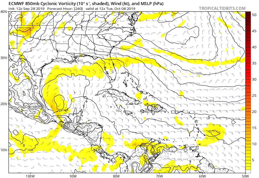
gatorcane wrote:12Z Euro shows the wave that could spark genesis in the Western Caribbean approaching the Lesser Antilles:

https://i.postimg.cc/xT7nhyGx/ecmwf-uv850-vort-watl-11.png

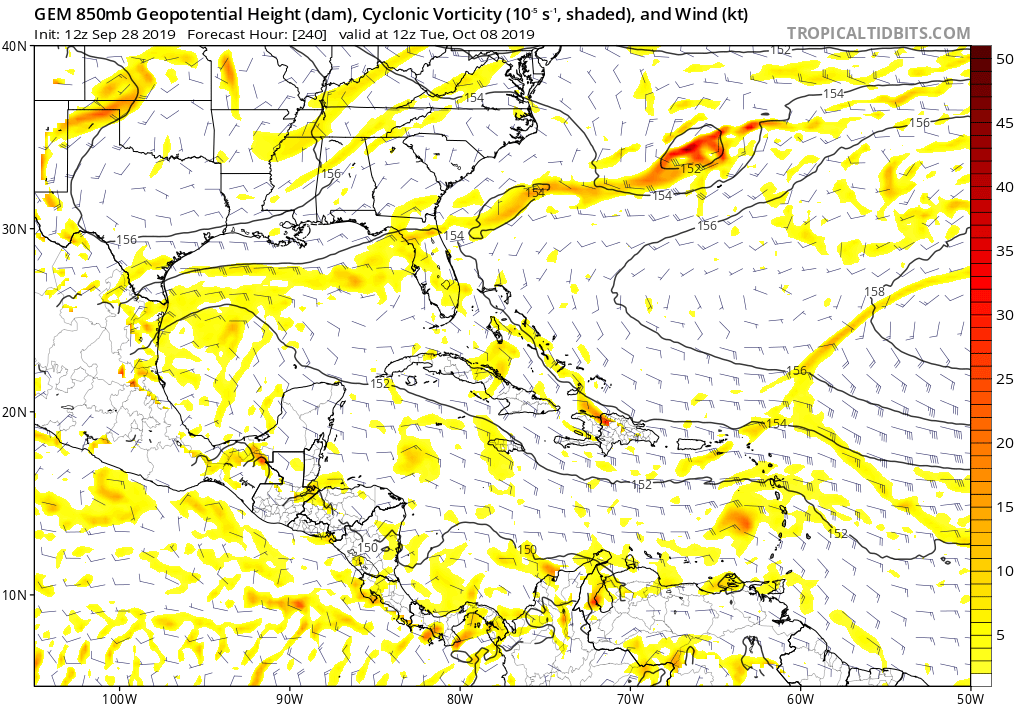
CMC a little faster with the wave:

https://i.postimg.cc/KYbzpDxX/gem-z850-vort-watl-41.png


Hi Gatorcane, as you know Caribbean storms this time of year can be a pain to predict.
0 likes   

User avatar
Hurricaneman
Category 5
Category 5
Posts: 7351
Age: 45
Joined: Tue Aug 31, 2004 3:24 pm
Location: central florida

Re: 2019 Tropics: Global Model Runs Discussion (Out to day 16)

#882 Postby Hurricaneman » Sat Sep 28, 2019 6:52 pm

Looks like the wave that the GFS was developing a few days ago in the long range ends up over Mexico never develops but the wave behind starts developing in the western Caribbean at 324 hrs and the GFS for the last several runs has latched on to it, its entering west Africa currently
0 likes   

LarryWx
S2K Supporter
S2K Supporter
Posts: 6308
Joined: Sun Sep 07, 2003 2:04 pm
Location: GA

Re: 2019 Tropics: Global Model Runs Discussion (Out to day 16)

#883 Postby LarryWx » Sat Sep 28, 2019 7:16 pm

SFLcane wrote:I see overnight GFS was fun but Euro/EPS not much to see.


Today’s 6Z/12Z/18Z GEFS runs have been much less impressive than those very impressive prior GEFS runs for 10/8-12 overall. Those had up to 50% of members with 999 mb or lower pressure! Also, the 0Z/12Z EPS continue to be unimpressed. So, in my mind the chance that those very active GEFS runs were tracking a phantom has increased some vs 24 hours ago. Keep in mind the GEFS history of sometimes tracking W Car phantoms in Oct.
2 likes   
Personal Forecast Disclaimer:
The posts in this forum are NOT official forecasts and should not be used as such. They are just the opinion of the poster and may or may not be backed by sound meteorological data. They are NOT endorsed by any professional institution or storm2k.org. For official information, please refer to the NHC and NWS products.

User avatar
SFLcane
S2K Supporter
S2K Supporter
Posts: 10163
Age: 47
Joined: Sat Jun 05, 2010 1:44 pm
Location: Lake Worth Florida

Re: 2019 Tropics: Global Model Runs Discussion (Out to day 16)

#884 Postby SFLcane » Sat Sep 28, 2019 7:49 pm

LarryWx wrote:
SFLcane wrote:I see overnight GFS was fun but Euro/EPS not much to see.


Today’s 6Z/12Z/18Z GEFS runs have been much less impressive than those very impressive prior GEFS runs for 10/8-12 overall. Those had up to 50% of members with 999 mb or lower pressure! Also, the 0Z/12Z EPS continue to be unimpressed. So, in my mind the chance that those very active GEFS runs were tracking a phantom has increased some vs 24 hours ago. Keep in mind the GEFS history of sometimes tracking W Car phantoms in Oct.


Well there's some EPS signal and it would be weird to go all October with absolutely nothing. It has something forming in about 6-7 days. How strong it’s anyone’s guess
0 likes   

LarryWx
S2K Supporter
S2K Supporter
Posts: 6308
Joined: Sun Sep 07, 2003 2:04 pm
Location: GA

Re: 2019 Tropics: Global Model Runs Discussion (Out to day 16)

#885 Postby LarryWx » Sat Sep 28, 2019 8:22 pm

SFLcane wrote:
LarryWx wrote:
SFLcane wrote:I see overnight GFS was fun but Euro/EPS not much to see.


Today’s 6Z/12Z/18Z GEFS runs have been much less impressive than those very impressive prior GEFS runs for 10/8-12 overall. Those had up to 50% of members with 999 mb or lower pressure! Also, the 0Z/12Z EPS continue to be unimpressed. So, in my mind the chance that those very active GEFS runs were tracking a phantom has increased some vs 24 hours ago. Keep in mind the GEFS history of sometimes tracking W Car phantoms in Oct.


Well there's some EPS signal and it would be weird to go all October with absolutely nothing. It has something forming in about 6-7 days. How strong it’s anyone’s guess


Yeah, I see that moderate EPS signal in the W Caribbean although that’s for something quite a bit earlier than what those wild GEFS runs were showing.
0 likes   
Personal Forecast Disclaimer:
The posts in this forum are NOT official forecasts and should not be used as such. They are just the opinion of the poster and may or may not be backed by sound meteorological data. They are NOT endorsed by any professional institution or storm2k.org. For official information, please refer to the NHC and NWS products.

User avatar
Hurricaneman
Category 5
Category 5
Posts: 7351
Age: 45
Joined: Tue Aug 31, 2004 3:24 pm
Location: central florida

Re: 2019 Tropics: Global Model Runs Discussion (Out to day 16)

#886 Postby Hurricaneman » Sat Sep 28, 2019 11:56 pm

If you go by the GFS Melissa will be a tropical storm Landfall failing to make a name for itself like all the other female names this year but the wave behind may be Nestor and could be the one to really watch but as we all know the models will change from run to run so don’t count on this but it’s possible because the Euro shows the same system the 0zGFS shows so the front one is somewhat likely to develop while the one behind isn’t a guarantee
2 likes   

User avatar
Emmett_Brown
Category 5
Category 5
Posts: 1432
Joined: Wed Aug 24, 2005 9:10 pm
Location: Sarasota FL

Re: 2019 Tropics: Global Model Runs Discussion (Out to day 16)

#887 Postby Emmett_Brown » Sun Sep 29, 2019 6:52 am

Just a side note about model performance and how they handle genesis this year... it seems like the only storm that all the models saw coming was Lorenzo... they pretty much all had it for days before development. Ironically, he is one of the larger storms (in overall size) of the last several years. Models have been playing catchup with genesis of the smaller storms (Dorian the most obvious example, but there are other examples). So the fact that the Euro is showing a nearly closed low later this week near the Yucatan raises a flag... something could certainly develop there.
4 likes   

User avatar
mpic
S2K Supporter
S2K Supporter
Posts: 622
Joined: Thu Oct 20, 2005 11:24 am
Location: Splendora, TX

Re: 2019 Tropics: Global Model Runs Discussion (Out to day 16)

#888 Postby mpic » Sun Sep 29, 2019 10:37 am

Hurricaneman wrote:If you go by the GFS Melissa will be a tropical storm Landfall failing to make a name for itself like all the other female names this year but the wave behind may be Nestor and could be the one to really watch but as we all know the models will change from run to run so don’t count on this but it’s possible because the Euro shows the same system the 0zGFS shows so the front one is somewhat likely to develop while the one behind isn’t a guarantee


People in my area who lost everything they have would disagree with you about Imelda. Won't forget that name any time soon.
2 likes   
Alicia, Rita, Ike, Harvey and Beryl...moved to Splendora lol

User avatar
Hurricaneman
Category 5
Category 5
Posts: 7351
Age: 45
Joined: Tue Aug 31, 2004 3:24 pm
Location: central florida

Re: 2019 Tropics: Global Model Runs Discussion (Out to day 16)

#889 Postby Hurricaneman » Sun Sep 29, 2019 10:59 am

mpic wrote:
Hurricaneman wrote:If you go by the GFS Melissa will be a tropical storm Landfall failing to make a name for itself like all the other female names this year but the wave behind may be Nestor and could be the one to really watch but as we all know the models will change from run to run so don’t count on this but it’s possible because the Euro shows the same system the 0zGFS shows so the front one is somewhat likely to develop while the one behind isn’t a guarantee


People in my area who lost everything they have would disagree with you about Imelda. Won't forget that name any time soon.


Somehow forgot that one, that was too much rain in too little time

Back on topic, the wave the GFS develops long range is from a wave that moves off Tuesday which doesn’t develop until north of the Lesser Antilles but the southern part of the wave moves through the Caribbean and develops north of Panama
0 likes   

User avatar
toad strangler
S2K Supporter
S2K Supporter
Posts: 4543
Joined: Sun Jul 28, 2013 3:09 pm
Location: Earth
Contact:

Re: 2019 Tropics: Global Model Runs Discussion (Out to day 16)

#890 Postby toad strangler » Sun Sep 29, 2019 12:25 pm

12z GFS with another probable phantom huge Caribbean hurricane in the long range. It has been showing this set up off and on for a few days in between losing it and not moving it up much. So for now, grain of salt.
1 likes   

User avatar
gatorcane
S2K Supporter
S2K Supporter
Posts: 23691
Age: 47
Joined: Sun Mar 13, 2005 3:54 pm
Location: Boca Raton, FL

Re: 2019 Tropics: Global Model Runs Discussion (Out to day 16)

#891 Postby gatorcane » Sun Sep 29, 2019 12:30 pm

12Z GFS slowly moving NW when run ends:

Image
1 likes   

User avatar
wxman57
Moderator-Pro Met
Moderator-Pro Met
Posts: 22979
Age: 67
Joined: Sat Jun 21, 2003 8:06 pm
Location: Houston, TX (southwest)

Re: 2019 Tropics: Global Model Runs Discussion (Out to day 16)

#892 Postby wxman57 » Sun Sep 29, 2019 12:36 pm

I'm giving this storm a 100% chance of development. We start our annual vacation at Disney World on the 21st. Every year, a storm threatens or hits Florida the week before we arrive.
14 likes   

User avatar
SFLcane
S2K Supporter
S2K Supporter
Posts: 10163
Age: 47
Joined: Sat Jun 05, 2010 1:44 pm
Location: Lake Worth Florida

Re: 2019 Tropics: Global Model Runs Discussion (Out to day 16)

#893 Postby SFLcane » Sun Sep 29, 2019 1:07 pm

12z GFS has a very favorable Caribbean setup that would get us our 3rd Cat5 of the year. :eek:
0 likes   

TheStormExpert

Re: 2019 Tropics: Global Model Runs Discussion (Out to day 16)

#894 Postby TheStormExpert » Sun Sep 29, 2019 1:15 pm

SFLcane wrote:12z GFS has a very favorable Caribbean setup that would get us our 3rd Cat5 of the year. :eek:

That's if you actually believe the GFS beyond 3-5 days. :wink:
0 likes   

User avatar
toad strangler
S2K Supporter
S2K Supporter
Posts: 4543
Joined: Sun Jul 28, 2013 3:09 pm
Location: Earth
Contact:

Re: 2019 Tropics: Global Model Runs Discussion (Out to day 16)

#895 Postby toad strangler » Sun Sep 29, 2019 1:21 pm

TheStormExpert wrote:
SFLcane wrote:12z GFS has a very favorable Caribbean setup that would get us our 3rd Cat5 of the year. :eek:

That's if you actually believe the GFS beyond 3-5 days. :wink:


I don't think anyone believes that run verbatim. It's more about the potential given forecasted set up / conditions
0 likes   

User avatar
Hurricaneman
Category 5
Category 5
Posts: 7351
Age: 45
Joined: Tue Aug 31, 2004 3:24 pm
Location: central florida

Re: 2019 Tropics: Global Model Runs Discussion (Out to day 16)

#896 Postby Hurricaneman » Sun Sep 29, 2019 1:26 pm

SFLcane wrote:12z GFS has a very favorable Caribbean setup that would get us our 3rd Cat5 of the year. :eek:


Not sure it will happen this way but the 12zGFS shows a setup close to Wilma in 2005, but it’s in fantasy range so while it could still happen given the favorable environment it probably won’t happen exactly as modeled
1 likes   

User avatar
Hurricaneman
Category 5
Category 5
Posts: 7351
Age: 45
Joined: Tue Aug 31, 2004 3:24 pm
Location: central florida

Re: 2019 Tropics: Global Model Runs Discussion (Out to day 16)

#897 Postby Hurricaneman » Sun Sep 29, 2019 2:01 pm

Looks like the Euro is joining the GFS with lowering pressures in the SW Caribbean, this may be a real system as it can be tracked back to Western Africa

Also it looks like multiple CAG systems may be possible as the pattern looks to last a few weeks longer
0 likes   

User avatar
SFLcane
S2K Supporter
S2K Supporter
Posts: 10163
Age: 47
Joined: Sat Jun 05, 2010 1:44 pm
Location: Lake Worth Florida

Re: 2019 Tropics: Global Model Runs Discussion (Out to day 16)

#898 Postby SFLcane » Sun Sep 29, 2019 2:26 pm

Hurricaneman wrote:Looks like the Euro is joining the GFS with lowering pressures in the SW Caribbean, this may be a real system as it can be tracked back to Western Africa

Also it looks like multiple CAG systems may be possible as the pattern looks to last a few weeks longer


I am not seeing any lowering pressures care to put it out?
0 likes   

User avatar
Hurricaneman
Category 5
Category 5
Posts: 7351
Age: 45
Joined: Tue Aug 31, 2004 3:24 pm
Location: central florida

Re: 2019 Tropics: Global Model Runs Discussion (Out to day 16)

#899 Postby Hurricaneman » Sun Sep 29, 2019 3:30 pm

SFLcane wrote:
Hurricaneman wrote:Looks like the Euro is joining the GFS with lowering pressures in the SW Caribbean, this may be a real system as it can be tracked back to Western Africa

Also it looks like multiple CAG systems may be possible as the pattern looks to last a few weeks longer


I am not seeing any lowering pressures care to put it out?

Just north of panama but its really broad, I could be reading too much into it though
0 likes   

LarryWx
S2K Supporter
S2K Supporter
Posts: 6308
Joined: Sun Sep 07, 2003 2:04 pm
Location: GA

Re: 2019 Tropics: Global Model Runs Discussion (Out to day 16)

#900 Postby LarryWx » Sun Sep 29, 2019 4:18 pm

The 12Z EPS is unimpressed with any Caribbean threat in the 11-15 day period. Frankly, it is quiet on the run with only a couple of members out of 51 having a SLP of 1003 or lower. It can't get much quieter than that.
Last edited by LarryWx on Sun Sep 29, 2019 4:22 pm, edited 1 time in total.
1 likes   
Personal Forecast Disclaimer:
The posts in this forum are NOT official forecasts and should not be used as such. They are just the opinion of the poster and may or may not be backed by sound meteorological data. They are NOT endorsed by any professional institution or storm2k.org. For official information, please refer to the NHC and NWS products.


Return to “Talkin' Tropics”

Who is online

Users browsing this forum: jaguars_22, jconsor, KeysRedWine, Ulf and 44 guests