2020 Global Model Runs Discussion (Out thru day 16)

This is the general tropical discussion area. Anyone can take their shot at predicting a storms path.

Moderator: S2k Moderators

Forum rules

The posts in this forum are NOT official forecasts and should not be used as such. They are just the opinion of the poster and may or may not be backed by sound meteorological data. They are NOT endorsed by any professional institution or STORM2K. For official information, please refer to products from the National Hurricane Center and National Weather Service.

Help Support Storm2K
Message
Author
User avatar
toad strangler
S2K Supporter
S2K Supporter
Posts: 4543
Joined: Sun Jul 28, 2013 3:09 pm
Location: Earth
Contact:

Re: 2020 Global Model Runs Discussion (Out thru day 16)

#161 Postby toad strangler » Sun May 24, 2020 6:29 pm

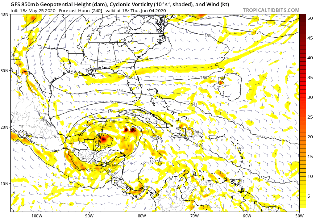
cycloneye wrote:The only thing I am saying is "GFS is crazy".


yeah that looks like an October set up :lol:
3 likes   

User avatar
N2FSU
S2K Supporter
S2K Supporter
Posts: 1062
Joined: Thu Sep 04, 2003 2:04 pm
Location: Tallahassee, FL

Re: 2020 Global Model Runs Discussion (Out thru day 16)

#162 Postby N2FSU » Mon May 25, 2020 6:06 am

6z GFSImageImageImage


Sent from my iPhone using Tapatalk
0 likes   

User avatar
GCANE
S2K Supporter
S2K Supporter
Posts: 11496
Joined: Mon Oct 22, 2007 8:03 am

Re: 2020 Global Model Runs Discussion (Out thru day 16)

#163 Postby GCANE » Mon May 25, 2020 8:43 am

Starting to take this seriously

Image
1 likes   

User avatar
Ivanhater
Storm2k Moderator
Storm2k Moderator
Posts: 11160
Age: 38
Joined: Fri Jul 01, 2005 8:25 am
Location: Pensacola

Re: 2020 Global Model Runs Discussion (Out thru day 16)

#164 Postby Ivanhater » Mon May 25, 2020 8:56 am

Very active pattern so far and it's still May
0 likes   
Michael

User avatar
GCANE
S2K Supporter
S2K Supporter
Posts: 11496
Joined: Mon Oct 22, 2007 8:03 am

Re: 2020 Global Model Runs Discussion (Out thru day 16)

#165 Postby GCANE » Mon May 25, 2020 9:06 am

If the middle-level vorts survive the cross-over, conditions in the west Carib look conducive for development including low & mid-level moisture and 355K PV.
IMHO, it appears there may be enough of a shear gradient to keep convection firing as it enters the GOM.
2 likes   

User avatar
Ubuntwo
Category 5
Category 5
Posts: 1406
Age: 31
Joined: Thu Oct 05, 2017 10:41 pm

Re: 2020 Global Model Runs Discussion (Out thru day 16)

#166 Postby Ubuntwo » Mon May 25, 2020 12:02 pm

There is a lot going on in the 12z GFS:

The disturbance in the Gulf quickly spins up into a TD (h18)

A short-lived TS in the western Caribbean, crashes into the Yucatan (h180)

A strong TS in the Caribbean, first stalls, then turns north and weakens after nearly making landfall on Jamaica - reforms in the open Atlantic (h192)

A TS that forms off the Cuban coast, moves over the Bahamas, possibly becomes subtropical? (h312)

That could be three more named storms by the second week of June. The fact that the GFS is spitting out cyclones like this is indicative of a favorable base state throughout the western basin.
1 likes   
Kendall -> SLO -> PBC

Memorable Storms: Katrina (for its Florida landfall...) Wilma Matthew Irma

User avatar
cycloneye
Admin
Admin
Posts: 145285
Age: 68
Joined: Thu Oct 10, 2002 10:54 am
Location: San Juan, Puerto Rico

Re: 2020 Global Model Runs Discussion (Out thru day 16)

#167 Postby cycloneye » Mon May 25, 2020 12:17 pm

I said it yesterday and today mantain it: GFS is crazy.
6 likes   
Visit the Caribbean-Central America Weather Thread where you can find at first post web cams,radars
and observations from Caribbean basin members Click Here

User avatar
Ivanhater
Storm2k Moderator
Storm2k Moderator
Posts: 11160
Age: 38
Joined: Fri Jul 01, 2005 8:25 am
Location: Pensacola

Re: 2020 Global Model Runs Discussion (Out thru day 16)

#168 Postby Ivanhater » Mon May 25, 2020 12:18 pm

Gfs doesn't know what to do with the gyre, but odds of something coming is getting stronger. Very active pattern before hurricane season has started.
3 likes   
Michael

User avatar
gatorcane
S2K Supporter
S2K Supporter
Posts: 23691
Age: 47
Joined: Sun Mar 13, 2005 3:54 pm
Location: Boca Raton, FL

Re: 2020 Global Model Runs Discussion (Out thru day 16)

#169 Postby gatorcane » Mon May 25, 2020 12:20 pm

Looks like a lot of convective feedback issues on the GFS. Does anybody know if it not getting the usual data it gets due to COVID-19?
2 likes   

User avatar
Ubuntwo
Category 5
Category 5
Posts: 1406
Age: 31
Joined: Thu Oct 05, 2017 10:41 pm

Re: 2020 Global Model Runs Discussion (Out thru day 16)

#170 Postby Ubuntwo » Mon May 25, 2020 12:27 pm

gatorcane wrote:Looks like a lot of convective feedback issues on the GFS. Does anybody know if it not getting the usual data it gets due to COVID-19?

Maybe the gfs is sick :spam:
1 likes   
Kendall -> SLO -> PBC

Memorable Storms: Katrina (for its Florida landfall...) Wilma Matthew Irma

User avatar
Ivanhater
Storm2k Moderator
Storm2k Moderator
Posts: 11160
Age: 38
Joined: Fri Jul 01, 2005 8:25 am
Location: Pensacola

Re: 2020 Global Model Runs Discussion (Out thru day 16)

#171 Postby Ivanhater » Mon May 25, 2020 12:45 pm

gatorcane wrote:Looks like a lot of convective feedback issues on the GFS. Does anybody know if it not getting the usual data it gets due to COVID-19?

I don't think so, this has been going on for a few days. The gyre is happening. I think the northern cusp of it is what the models are struggling with.
1 likes   
Michael

User avatar
gatorcane
S2K Supporter
S2K Supporter
Posts: 23691
Age: 47
Joined: Sun Mar 13, 2005 3:54 pm
Location: Boca Raton, FL

Re: 2020 Global Model Runs Discussion (Out thru day 16)

#172 Postby gatorcane » Mon May 25, 2020 1:38 pm

Noticeable uptick with the GFS ensembles with some strong members but still long-range:

Image
6 likes   

User avatar
cycloneye
Admin
Admin
Posts: 145285
Age: 68
Joined: Thu Oct 10, 2002 10:54 am
Location: San Juan, Puerto Rico

Re: 2020 Global Model Runs Discussion (Out thru day 16)

#173 Postby cycloneye » Mon May 25, 2020 1:58 pm

12z ECMWF has no crossover.
2 likes   
Visit the Caribbean-Central America Weather Thread where you can find at first post web cams,radars
and observations from Caribbean basin members Click Here

stormlover2013

Re: 2020 Global Model Runs Discussion (Out thru day 16)

#174 Postby stormlover2013 » Mon May 25, 2020 2:12 pm

Lol gfs is so bad long range
2 likes   

User avatar
gatorcane
S2K Supporter
S2K Supporter
Posts: 23691
Age: 47
Joined: Sun Mar 13, 2005 3:54 pm
Location: Boca Raton, FL

Re: 2020 Global Model Runs Discussion (Out thru day 16)

#175 Postby gatorcane » Mon May 25, 2020 2:21 pm

GEPS long-range:

Image
3 likes   

floridasun78
Category 5
Category 5
Posts: 3755
Joined: Sun May 17, 2009 10:16 pm
Location: miami fl

Re: 2020 Global Model Runs Discussion (Out thru day 16)

#176 Postby floridasun78 » Mon May 25, 2020 2:27 pm

i think we need see what show that area by models by next weekend gfs could be wrong or right too early to say but do look like tropical dont want wait untill july or aug to get active
0 likes   

User avatar
SFLcane
S2K Supporter
S2K Supporter
Posts: 10163
Age: 47
Joined: Sat Jun 05, 2010 1:44 pm
Location: Lake Worth Florida

Re: 2020 Global Model Runs Discussion (Out thru day 16)

#177 Postby SFLcane » Mon May 25, 2020 4:49 pm

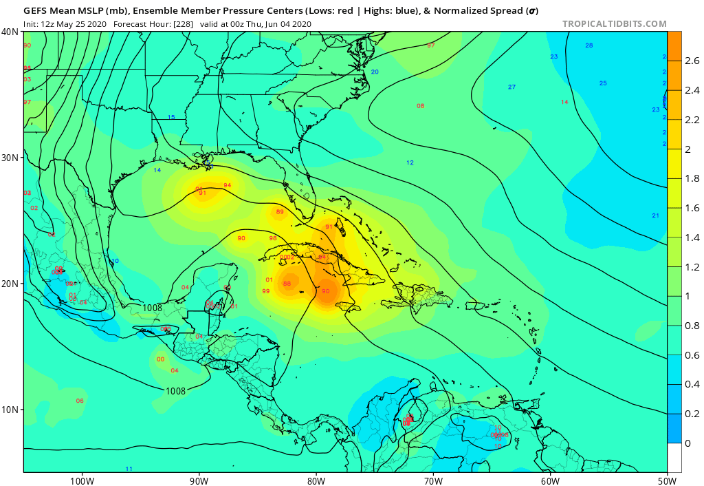
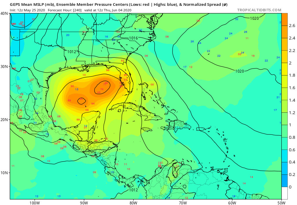
gatorcane wrote:Noticeable uptick with the GFS ensembles with some strong members but still long-range:

https://i.postimg.cc/FzXy8QBG/gfs-ememb-lowlocs-watl-39.png


Highly skeptical of that solution at the moment. Given the EPS is almost all EPAC or far SW Gomex. Maybe one member out of 50 similar to GEFS.

Image
0 likes   

User avatar
NDG
S2K Supporter
S2K Supporter
Posts: 15446
Joined: Sun Jul 09, 2006 10:14 pm
Location: Orlando, FL

Re: 2020 Global Model Runs Discussion (Out thru day 16)

#178 Postby NDG » Mon May 25, 2020 5:04 pm

The reason why the latest Euro likes possible development over the EPAC and a track westward south of MX is because it builds a stronger ridging across the south central US into eastern MX while the GFS ensemble mean has the ridging further north across the Great Lakes.
The Euro had the trough across TX and GOM much weaker 7-10 days ago.
1 likes   

User avatar
gatorcane
S2K Supporter
S2K Supporter
Posts: 23691
Age: 47
Joined: Sun Mar 13, 2005 3:54 pm
Location: Boca Raton, FL

Re: 2020 Global Model Runs Discussion (Out thru day 16)

#179 Postby gatorcane » Mon May 25, 2020 5:59 pm

18Z GFS insists this crosses over and a CAG / broad low develops over the NW Caribbean lifting slowly north:

Image
1 likes   

User avatar
Ivanhater
Storm2k Moderator
Storm2k Moderator
Posts: 11160
Age: 38
Joined: Fri Jul 01, 2005 8:25 am
Location: Pensacola

Re: 2020 Global Model Runs Discussion (Out thru day 16)

#180 Postby Ivanhater » Mon May 25, 2020 8:31 pm

Typical CAG low, keep an eye on the northern flank..
0 likes   
Michael


Return to “Talkin' Tropics”

Who is online

Users browsing this forum: Stormybajan and 40 guests