toad strangler wrote:http://twitter.com/BigJoeBastardi/status/1283166472722878466?s=20
Models are literally chirping crickets for all basins across the work except the EPAC. Even in the EPAC the models have been a bit over zealous.
Moderator: S2k Moderators


toad strangler wrote:http://twitter.com/BigJoeBastardi/status/1283166472722878466?s=20
gatorcane wrote:toad strangler wrote:http://twitter.com/BigJoeBastardi/status/1283166472722878466?s=20
Models are literally chirping crickets for all basins across the work except the EPAC. Even in the EPAC the models have been a bit over zealous.
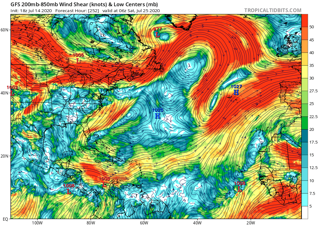


gatorcane wrote:The GFS shear looks El-Niño-like if you ask me. It is ripping across the Caribbean with a huge TUTT over the Bahamas. No wonder the model can’t develop anything. Well that and the dry air too. We will need to give things some time to quiet down as far as the shear because this is downright hostile across the Caribbean and MDR. Again it is typical for this time of year but not of a hyperactive season that starts in July:
https://i.postimg.cc/XqrtyQQm/gfs-shear-atl-43.png

gatorcane wrote:toad strangler wrote:http://twitter.com/BigJoeBastardi/status/1283166472722878466?s=20
Models are literally chirping crickets for all basins across the work except the EPAC. Even in the EPAC the models have been a bit over zealous.


stormlover2013 wrote:https://www.tropicaltidbits.com/analysis/models/?model=icon®ion=watl&pkg=mslp_pcpn&runtime=2020071500&fh=0
Icon trying to hint at something


Ubuntwo wrote:https://cdn.discordapp.com/attachments/289981599448039425/732809677943078932/gfs_mslp_wind_eatl_fh0-114.gif
https://cdn.discordapp.com/attachments/289981599448039425/732810422222061608/gfs_z850_vort_eatl_10.png
The GFS comes in stronger with this eastern MDR thing, 1006mb.
The NNE-wardly motion is a climo anomaly but makes sense considering the state of trades in the area.
The Euro supports genesis here as well. A short-lived depression would be no surprise.

Ubuntwo wrote:The GFS comes in stronger with this eastern MDR thing, 1006mb.
The NNE-wardly motion is a climo anomaly but makes sense considering the state of trades in the area.
The Euro supports genesis here as well. A short-lived depression would be no surprise.


IsabelaWeather wrote:Ubuntwo wrote:The GFS comes in stronger with this eastern MDR thing, 1006mb.
The NNE-wardly motion is a climo anomaly but makes sense considering the state of trades in the area.
The Euro supports genesis here as well. A short-lived depression would be no surprise.
I posted in the other thread infrared satellite, it already looks like there is some weak rotation to it. 400-700mb is also moist. I wouldnt be shocked to see an invest really soon.
If any TC starts, it will be interesting to see if it really does die or if it can mosey on west.
Here is a better gif I made:https://i.imgur.com/ya9ShCt.gif


gatorcane wrote:The GFS shear looks El-Niño-like if you ask me. It is ripping across the Caribbean with a huge TUTT over the Bahamas. No wonder the model can’t develop anything. Well that and the dry air too. We will need to give things some time to quiet down as far as the shear because this is downright hostile across the Caribbean and MDR. Again it is typical for this time of year but not of a hyperactive season that starts in July:
https://i.postimg.cc/XqrtyQQm/gfs-shear-atl-43.png
Users browsing this forum: Google Adsense [Bot] and 110 guests


