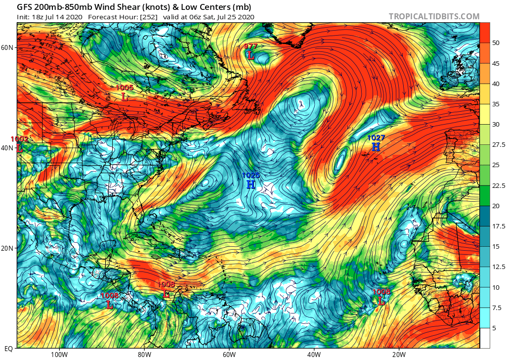
2020 Global Model Runs Discussion (Out thru day 16)

This is the general tropical discussion area. Anyone can take their shot at predicting a storms path.

Moderator: S2k Moderators

Forum rules

The posts in this forum are NOT official forecasts and should not be used as such. They are just the opinion of the poster and may or may not be backed by sound meteorological data. They are NOT endorsed by any professional institution or STORM2K. For official information, please refer to products from the National Hurricane Center and National Weather Service.

Help Support Storm2K
Message
Author
User avatar
toad strangler
S2K Supporter
S2K Supporter
Posts: 4543
Joined: Sun Jul 28, 2013 3:09 pm
Location: Earth
Contact:

Re: 2020 Global Model Runs Discussion (Out thru day 16)

#761 Postby toad strangler » Wed Jul 15, 2020 9:06 am

SFLcane wrote:
gatorcane wrote:The GFS shear looks El-Niño-like if you ask me. It is ripping across the Caribbean with a huge TUTT over the Bahamas. No wonder the model can’t develop anything. Well that and the dry air too. We will need to give things some time to quiet down as far as the shear because this is downright hostile across the Caribbean and MDR. Again it is typical for this time of year but not of a hyperactive season that starts in July:

https://i.postimg.cc/XqrtyQQm/gfs-shear-atl-43.png


Gatorcane, what exactly are you looking at? Shear is definitely not the issue right now across the basin. Once the sinking airmass moves out look for things to really get going.


He posted a 252 hour 200-850 mb GFS millibar sheer map when making those points. I assume that's is what he was looking at.
0 likes   

User avatar
SFLcane
S2K Supporter
S2K Supporter
Posts: 10163
Age: 47
Joined: Sat Jun 05, 2010 1:44 pm
Location: Lake Worth Florida

Re: 2020 Global Model Runs Discussion (Out thru day 16)

#762 Postby SFLcane » Wed Jul 15, 2020 9:11 am

toad strangler wrote:
SFLcane wrote:
gatorcane wrote:The GFS shear looks El-Niño-like if you ask me. It is ripping across the Caribbean with a huge TUTT over the Bahamas. No wonder the model can’t develop anything. Well that and the dry air too. We will need to give things some time to quiet down as far as the shear because this is downright hostile across the Caribbean and MDR. Again it is typical for this time of year but not of a hyperactive season that starts in July:

https://i.postimg.cc/XqrtyQQm/gfs-shear-atl-43.png


Gatorcane, what exactly are you looking at? Shear is definitely not the issue right now across the basin. Once the sinking airmass moves out look for things to really get going.


He posted a 252 hour 200-850 mb GFS millibar sheer map when making those points. I assume that's is what he was looking at.


Well he did mention El Niño like which is definitely not the case. The Caribbean for example has seen very low shear in July which is a precursor of things to come.
1 likes   

User avatar
alienstorm
Category 1
Category 1
Posts: 496
Joined: Tue Jul 31, 2007 1:29 pm
Location: Miami Fla western suburb

Re: 2020 Global Model Runs Discussion (Out thru day 16)

#763 Postby alienstorm » Wed Jul 15, 2020 9:26 am

Nice robust wave with a circulation not sure it will survive the dry stable atmosphere as it treks through the Atlantic

https://weather.us/satellite/264-w-107- ... 1400z.html
1 likes   
Personal Forecast Disclaimer:The posts in this forum are NOT official forecast and should not be used as such. They are just the opinion of the poster and may or may not be backed by sound meteorological data. They are NOT endorsed by any professional institution or storm2k.org. For official information, please refer to the NHC and NWS products.

User avatar
Steve
S2K Supporter
S2K Supporter
Posts: 9621
Joined: Sat Apr 05, 2003 11:41 pm
Location: Not a state-caster

Re: 2020 Global Model Runs Discussion (Out thru day 16)

#764 Postby Steve » Wed Jul 15, 2020 11:56 am

GFS is out to 294 hours on TT. It spins up a first low off Africa and heads up to the Cabo Verdes. The low right behind it is just south of Puerto Rico, closed-ish, 2 weeks from yesterday.

https://www.tropicaltidbits.com/analysi ... 512&fh=294

Closer to home, ICON wants to hint at a closed low in the Gulf of Mexico during its run. First an ULL forms in the central GOM and then moves toward Texas. You can see the shape in the rainbands along the MS/Al Coastlines. This is valid for the 23rd or 7 1/2 days.
https://www.tropicaltidbits.com/analysi ... 512&fh=180

Here's a look at mslp and 10m winds. You can see the hook barely close off just before it goes in on the SC LA Coast. Not much, but we're talking a week. So it's something to keep an eye out for.
https://www.tropicaltidbits.com/analysi ... 1512&fh=33
1 likes   

User avatar
DorkyMcDorkface
Category 3
Category 3
Posts: 888
Age: 27
Joined: Mon Sep 30, 2019 1:32 pm
Location: Mid-Atlantic

Re: 2020 Global Model Runs Discussion (Out thru day 16)

#765 Postby DorkyMcDorkface » Wed Jul 15, 2020 12:06 pm

Long-range EPS is starting to pick up on some (scattershot) activity by the end of the month:
Image
This is by far the most active run in a while.
3 likes   
Please note the thougths expressed by this account are solely those of the user and are from a hobbyist perspective. For more comprehensive analysis, consult an actual professional meteorologist or meteorology agency.


Floyd 1999 | Isabel 2003 | Hanna 2008 | Irene 2011 | Sandy 2012 | Isaias 2020

User avatar
Steve
S2K Supporter
S2K Supporter
Posts: 9621
Joined: Sat Apr 05, 2003 11:41 pm
Location: Not a state-caster

Re: 2020 Global Model Runs Discussion (Out thru day 16)

#766 Postby Steve » Wed Jul 15, 2020 12:13 pm

GFS ends its run with a closed 1010/1009mb low crossing extreme SFL and heading into the Gulf at 1008mb. Obviously July 31st (2 weeks from Friday) is fantasyland for models. But it tracks the low across the Atlantic to where it gets.

https://www.tropicaltidbits.com/analysi ... 512&fh=384

While the low comes up from the SE, you can see it crosses Florida East to West. Very limited chance this occurs, but it's on the model map.
1 likes   

AutoPenalti
Category 5
Category 5
Posts: 4030
Age: 29
Joined: Mon Aug 17, 2015 4:16 pm
Location: Ft. Lauderdale, Florida

Re: 2020 Global Model Runs Discussion (Out thru day 16)

#767 Postby AutoPenalti » Wed Jul 15, 2020 12:32 pm

DorkyMcDorkface wrote:Long-range EPS is starting to pick up on some (scattershot) activity by the end of the month:
https://i.ibb.co/jbGQ6tw/eps-cyclones-atlantic-360-2020071500-1.png
This is by far the most active run in a while.

I was about to mention where the heck you see how this run is the most active, until I saw the far right of the plot. :lol:
0 likes   
The posts in this forum are NOT official forecasts and should not be used as such. They are just the opinion of the poster and may or may not be backed by sound meteorological data. They are NOT endorsed by any professional institution or STORM2K. For official information, please refer to products from the NHC and NWS.


Model Runs Cheat Sheet:
GFS (5:30 AM/PM, 11:30 AM/PM)
HWRF, GFDL, UKMET, NAVGEM (6:30-8:00 AM/PM, 12:30-2:00 AM/PM)
ECMWF (1:45 AM/PM)

TCVN
is a weighted averaged

floridasun78
Category 5
Category 5
Posts: 3755
Joined: Sun May 17, 2009 10:16 pm
Location: miami fl

Re: 2020 Global Model Runs Discussion (Out thru day 16)

#768 Postby floridasun78 » Wed Jul 15, 2020 12:39 pm

no talk about wave on 2pm outlook
0 likes   

User avatar
wxman57
Moderator-Pro Met
Moderator-Pro Met
Posts: 22979
Age: 67
Joined: Sat Jun 21, 2003 8:06 pm
Location: Houston, TX (southwest)

Re: 2020 Global Model Runs Discussion (Out thru day 16)

#769 Postby wxman57 » Wed Jul 15, 2020 12:52 pm

I see the 12Z GFS has a TS entering the Gulf past south Florida on the 31st. I'm sure we can believe it. ;-) The rest of July looks more "normal" for July. No activity. Things should pick up considerably by the second week of August, as they typically do. Until then, I'll enjoy the quiet and will take some time off work.
10 likes   

User avatar
aspen
Category 5
Category 5
Posts: 8818
Joined: Sat Oct 12, 2019 7:10 pm
Location: Connecticut, USA

Re: 2020 Global Model Runs Discussion (Out thru day 16)

#770 Postby aspen » Wed Jul 15, 2020 1:07 pm

wxman57 wrote:I see the 12Z GFS has a TS entering the Gulf past south Florida on the 31st. I'm sure we can believe it. ;-) The rest of July looks more "normal" for July. No activity. Things should pick up considerably by the second week of August, as they typically do. Until then, I'll enjoy the quiet and will take some time off work.

That’s from the strong wave the GFS and Euro have shown coming off the coast of Africa in 180-200 hours.
0 likes   
Irene '11 Sandy '12 Hermine '16 5/15/2018 Derecho Fay '20 Isaias '20 Elsa '21 Henri '21 Ida '21

I am only a meteorology enthusiast who knows a decent amount about tropical cyclones. Look to the professional mets, the NHC, or your local weather office for the best information.

Aric Dunn
Category 5
Category 5
Posts: 21238
Age: 42
Joined: Sun Sep 19, 2004 9:58 pm
Location: Ready for the Chase.
Contact:

Re: 2020 Global Model Runs Discussion (Out thru day 16)

#771 Postby Aric Dunn » Wed Jul 15, 2020 2:08 pm

12z euro also showing similar to gfs.. i guess we can believe it now ? lol
2 likes   
Note: If I make a post that is brief. Please refer back to previous posts for the analysis or reasoning. I do not re-write/qoute what my initial post said each time.
If there is nothing before... then just ask :)

Space & Atmospheric Physicist, Embry-Riddle Aeronautical University,
I believe the sky is falling...

TheStormExpert

Re: 2020 Global Model Runs Discussion (Out thru day 16)

#772 Postby TheStormExpert » Wed Jul 15, 2020 2:16 pm

wxman57 wrote:I see the 12Z GFS has a TS entering the Gulf past south Florida on the 31st. I'm sure we can believe it. ;-) The rest of July looks more "normal" for July. No activity. Things should pick up considerably by the second week of August, as they typically do. Until then, I'll enjoy the quiet and will take some time off work.

Looks like the energy spits off the northern edge of a TW expected to exit the west coast of Africa on Monday.
0 likes   

TheStormExpert

Re: 2020 Global Model Runs Discussion (Out thru day 16)

#773 Postby TheStormExpert » Wed Jul 15, 2020 2:19 pm

Aric Dunn wrote:12z euro also showing similar to gfs.. i guess we can believe it now ? lol

The Euro must be showing a different wave entering the SE Bahamas at day 10 because at day 10 the 12z GFS has it just at or west of 50°W in the Tropical Atlantic.

All I know is the waves seem to be getting more intense looking so the lid is likely to come off the next few weeks.
3 likes   

User avatar
NDG
S2K Supporter
S2K Supporter
Posts: 15446
Joined: Sun Jul 09, 2006 10:14 pm
Location: Orlando, FL

Re: 2020 Global Model Runs Discussion (Out thru day 16)

#774 Postby NDG » Wed Jul 15, 2020 2:26 pm

That's one heck of a strong TW that is on the Euro's long range forecast, it has been trending stronger with it.

Image
8 likes   

AutoPenalti
Category 5
Category 5
Posts: 4030
Age: 29
Joined: Mon Aug 17, 2015 4:16 pm
Location: Ft. Lauderdale, Florida

Re: 2020 Global Model Runs Discussion (Out thru day 16)

#775 Postby AutoPenalti » Wed Jul 15, 2020 2:29 pm

NDG wrote:That's one heck of a strong TW that is on the Euro's long range forecast, it has been trending stronger with it.

https://i.imgur.com/8r054Jm.gif

That looks like a 'cane. :double:
1 likes   
The posts in this forum are NOT official forecasts and should not be used as such. They are just the opinion of the poster and may or may not be backed by sound meteorological data. They are NOT endorsed by any professional institution or STORM2K. For official information, please refer to products from the NHC and NWS.


Model Runs Cheat Sheet:
GFS (5:30 AM/PM, 11:30 AM/PM)
HWRF, GFDL, UKMET, NAVGEM (6:30-8:00 AM/PM, 12:30-2:00 AM/PM)
ECMWF (1:45 AM/PM)

TCVN
is a weighted averaged

User avatar
AnnularCane
S2K Supporter
S2K Supporter
Posts: 2862
Joined: Thu Jun 08, 2006 9:18 am
Location: Wytheville, VA

Re: 2020 Global Model Runs Discussion (Out thru day 16)

#776 Postby AnnularCane » Wed Jul 15, 2020 2:35 pm

:uarrow:

Yeah, for a minute there I thought it was an archived satellite image of some past TS or hurricane. :double:
0 likes   

stormlover2013

Re: 2020 Global Model Runs Discussion (Out thru day 16)

#777 Postby stormlover2013 » Wed Jul 15, 2020 2:46 pm

It’s going to heat up soon to the people that always man I don’t know if the season will be active and etc come on man common sense it’s coming
2 likes   

Aric Dunn
Category 5
Category 5
Posts: 21238
Age: 42
Joined: Sun Sep 19, 2004 9:58 pm
Location: Ready for the Chase.
Contact:

Re: 2020 Global Model Runs Discussion (Out thru day 16)

#778 Postby Aric Dunn » Wed Jul 15, 2020 2:50 pm

12z EPS starts showing that wave develop as early as 120 to 140 hours. well east of the carrib. Not a lot of members but as always, it typically slowly increases as we get closer.. or decreases.
Last edited by Aric Dunn on Wed Jul 15, 2020 2:52 pm, edited 1 time in total.
1 likes   
Note: If I make a post that is brief. Please refer back to previous posts for the analysis or reasoning. I do not re-write/qoute what my initial post said each time.
If there is nothing before... then just ask :)

Space & Atmospheric Physicist, Embry-Riddle Aeronautical University,
I believe the sky is falling...

User avatar
Kingarabian
S2K Supporter
S2K Supporter
Posts: 15981
Joined: Sat Aug 08, 2009 3:06 am
Location: Honolulu, Hawaii

Re: 2020 Global Model Runs Discussion (Out thru day 16)

#779 Postby Kingarabian » Wed Jul 15, 2020 2:50 pm

Yup very interesting Euro run.
0 likes   
RIP Kobe Bryant

User avatar
TheProfessor
Professional-Met
Professional-Met
Posts: 3506
Age: 28
Joined: Tue Dec 03, 2013 10:56 am
Location: Wichita, Kansas

Re: 2020 Global Model Runs Discussion (Out thru day 16)

#780 Postby TheProfessor » Wed Jul 15, 2020 2:59 pm

Meanwhile the 12z GEPS shows some support to the TD that the ICON is trying to form in the Northwest GoM early next week.
Image
4 likes   
An alumnus of The Ohio State University.

Your local National Weather Service office is your best source for weather information.


Return to “Talkin' Tropics”

Who is online

Users browsing this forum: 869MB, Google Adsense [Bot], hurricanes1234, LarryWx, USTropics and 63 guests