2020 Global Model Runs Discussion (Out thru day 16)

This is the general tropical discussion area. Anyone can take their shot at predicting a storms path.

Moderator: S2k Moderators

Forum rules

The posts in this forum are NOT official forecasts and should not be used as such. They are just the opinion of the poster and may or may not be backed by sound meteorological data. They are NOT endorsed by any professional institution or STORM2K. For official information, please refer to products from the National Hurricane Center and National Weather Service.

Help Support Storm2K
Message
Author
User avatar
toad strangler
S2K Supporter
S2K Supporter
Posts: 4543
Joined: Sun Jul 28, 2013 3:09 pm
Location: Earth
Contact:

Re: 2020 Global Model Runs Discussion (Out thru day 16)

#941 Postby toad strangler » Tue Jul 21, 2020 10:33 pm

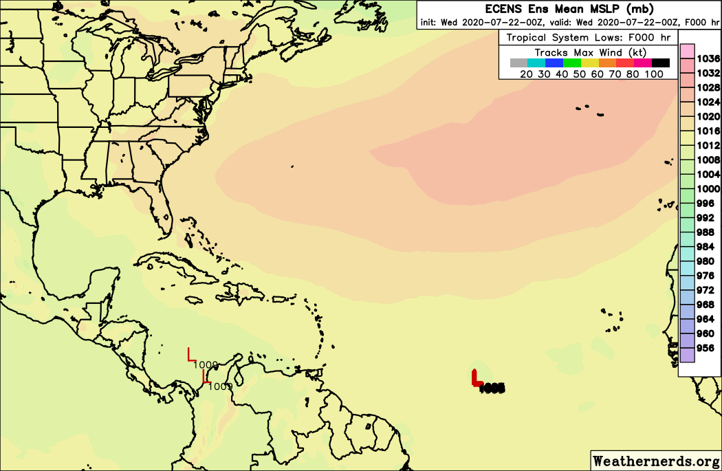
SoupBone wrote:I've not been paying much attention to the location of the Bermuda High. Would it allow recurves right now?


Of course. It's just a matter of where. :D
2 likes   

User avatar
Hurricaneman
Category 5
Category 5
Posts: 7351
Age: 45
Joined: Tue Aug 31, 2004 3:24 pm
Location: central florida

Re: 2020 Global Model Runs Discussion (Out thru day 16)

#942 Postby Hurricaneman » Tue Jul 21, 2020 11:30 pm

The 0zGFS still shows nothing where other models like the CMC and Euro seem to show a decent tropical system in the long range behind td7, could the GFS be slow on the uptake like it was with td7
0 likes   

User avatar
SFLcane
S2K Supporter
S2K Supporter
Posts: 10163
Age: 47
Joined: Sat Jun 05, 2010 1:44 pm
Location: Lake Worth Florida

Re: 2020 Global Model Runs Discussion (Out thru day 16)

#943 Postby SFLcane » Wed Jul 22, 2020 3:47 am

00z EPS not backing down still quite active.

Image
2 likes   

User avatar
cycloneye
Admin
Admin
Posts: 145324
Age: 68
Joined: Thu Oct 10, 2002 10:54 am
Location: San Juan, Puerto Rico

Re: 2020 Global Model Runs Discussion (Out thru day 16)

#944 Postby cycloneye » Wed Jul 22, 2020 5:08 am

Image
1 likes   
Visit the Caribbean-Central America Weather Thread where you can find at first post web cams,radars
and observations from Caribbean basin members Click Here

User avatar
SFLcane
S2K Supporter
S2K Supporter
Posts: 10163
Age: 47
Joined: Sat Jun 05, 2010 1:44 pm
Location: Lake Worth Florida

Re: 2020 Global Model Runs Discussion (Out thru day 16)

#945 Postby SFLcane » Wed Jul 22, 2020 7:21 am

Long range EPS wanting to recurve what ever gets into the Caribbean possibly northward. Will be interesting to watch unfold.

Image
0 likes   

TheStormExpert

Re: 2020 Global Model Runs Discussion (Out thru day 16)

#946 Postby TheStormExpert » Wed Jul 22, 2020 7:48 am

SFLcane wrote:Long range EPS wanting to recurve what ever gets into the Caribbean possibly northward. Will be interesting to watch unfold.

https://i.imgur.com/1DdXQwD.png

Assuming this actually develops considering the GFS shows nothing it’ll be interesting to see if this recurves East of Florida in The Bahamas, over Florida, or north into the Gulf. It looks like there will be a trough directly over the NE U.S. in 10 days or so.
0 likes   


User avatar
toad strangler
S2K Supporter
S2K Supporter
Posts: 4543
Joined: Sun Jul 28, 2013 3:09 pm
Location: Earth
Contact:

Re: 2020 Global Model Runs Discussion (Out thru day 16)

#948 Postby toad strangler » Wed Jul 22, 2020 8:05 am

TheStormExpert wrote:
SFLcane wrote:Long range EPS wanting to recurve what ever gets into the Caribbean possibly northward. Will be interesting to watch unfold.

https://i.imgur.com/1DdXQwD.png

Assuming this actually develops considering the GFS shows nothing it’ll be interesting to see if this recurves East of Florida in The Bahamas, over Florida, or north into the Gulf. It looks like there will be a trough directly over the NE U.S. in 10 days or so.


Yeah I saw that in 500mb but it's so far north Gonzalo wouldn't feel it. Also Gonzalo could very well not be structured enough to be steered by 500mb at that time. I hesitate to mention these setups past 5 days :D
0 likes   

User avatar
aspen
Category 5
Category 5
Posts: 8818
Joined: Sat Oct 12, 2019 7:10 pm
Location: Connecticut, USA

Re: 2020 Global Model Runs Discussion (Out thru day 16)

#949 Postby aspen » Wed Jul 22, 2020 8:10 am

SFLcane wrote:00z EPS not backing down still quite active.

https://iili.io/dx57Lb.gif

The second MDR system seems to form in 5-6 days, and the precursor wave moves off the coast of Africa in 3 days. I think the NHC might mark the area tomorrow.
1 likes   
Irene '11 Sandy '12 Hermine '16 5/15/2018 Derecho Fay '20 Isaias '20 Elsa '21 Henri '21 Ida '21

I am only a meteorology enthusiast who knows a decent amount about tropical cyclones. Look to the professional mets, the NHC, or your local weather office for the best information.

sma10
Category 5
Category 5
Posts: 1710
Joined: Tue Aug 02, 2005 1:13 pm

Re: 2020 Global Model Runs Discussion (Out thru day 16)

#950 Postby sma10 » Wed Jul 22, 2020 12:20 pm

12Z CMC full of only bad news today
0 likes   

User avatar
SFLcane
S2K Supporter
S2K Supporter
Posts: 10163
Age: 47
Joined: Sat Jun 05, 2010 1:44 pm
Location: Lake Worth Florida

Re: 2020 Global Model Runs Discussion (Out thru day 16)

#951 Postby SFLcane » Wed Jul 22, 2020 12:31 pm

sma10 wrote:12Z CMC full of only bad news today


Image
0 likes   

HurricaneFrances04
Category 2
Category 2
Posts: 597
Joined: Mon Jun 25, 2012 8:09 am
Location: Fort Lauderdale, Florida

Re: 2020 Global Model Runs Discussion (Out thru day 16)

#952 Postby HurricaneFrances04 » Wed Jul 22, 2020 12:40 pm

There's the July everyone needed to see for a hyperactive season. Looks like the lid is coming off a month earlier than normal.
7 likes   

supercane4867
Category 5
Category 5
Posts: 4966
Joined: Wed Nov 14, 2012 10:43 am

Re: 2020 Global Model Runs Discussion (Out thru day 16)

#953 Postby supercane4867 » Wed Jul 22, 2020 2:02 pm

Image
0 likes   

User avatar
captainbarbossa19
Professional-Met
Professional-Met
Posts: 1092
Age: 27
Joined: Wed Aug 21, 2019 11:09 pm
Location: Beaumont, TX

Re: 2020 Global Model Runs Discussion (Out thru day 16)

#954 Postby captainbarbossa19 » Wed Jul 22, 2020 2:08 pm


Even though the Euro said "goodbye" to Gonzalo, it appears to be suggesting that the Caribbean might become more cozy for storms in the near-future.
Last edited by captainbarbossa19 on Wed Jul 22, 2020 2:21 pm, edited 1 time in total.
0 likes   

sma10
Category 5
Category 5
Posts: 1710
Joined: Tue Aug 02, 2005 1:13 pm

Re: 2020 Global Model Runs Discussion (Out thru day 16)

#955 Postby sma10 » Wed Jul 22, 2020 2:08 pm

Honestly can't believe that there is a reasonable chance that we will already be thru the "I" storm before the end of July
4 likes   

User avatar
aspen
Category 5
Category 5
Posts: 8818
Joined: Sat Oct 12, 2019 7:10 pm
Location: Connecticut, USA

Re: 2020 Global Model Runs Discussion (Out thru day 16)

#956 Postby aspen » Wed Jul 22, 2020 2:12 pm

A quick run down of the 12z global model runs:

GFS still shows nothing except for a dying Gonzalo

Euro kills Gonzalo as well but has a forming TC in the MDR by 120 hours, and it survives into the Caribbean. 91L peaks at 994 mbar OVER LAND; that’s probably suggesting it could try to rapidly develop before landfall.

CMC keeps Gonzalo alive through the Caribbean and into the Gulf in a track similar to Emily or Allen. It also develops the second MDR system and brings it to hurricane status.

ICON also develops 91L and has a 1001 mbar landfall mid/late Saturday. It also kills off Gonzalo and develops the second MDR system.
1 likes   
Irene '11 Sandy '12 Hermine '16 5/15/2018 Derecho Fay '20 Isaias '20 Elsa '21 Henri '21 Ida '21

I am only a meteorology enthusiast who knows a decent amount about tropical cyclones. Look to the professional mets, the NHC, or your local weather office for the best information.

User avatar
Ubuntwo
Category 5
Category 5
Posts: 1406
Age: 31
Joined: Thu Oct 05, 2017 10:41 pm

Re: 2020 Global Model Runs Discussion (Out thru day 16)

#957 Postby Ubuntwo » Wed Jul 22, 2020 2:14 pm

aspen wrote:A quick run down of the 12z global model runs:

GFS still shows nothing except for a dying Gonzalo

Euro kills Gonzalo as well but has a forming TC in the MDR by 120 hours, and it survives into the Caribbean. 91L peaks at 994 mbar OVER LAND; that’s probably suggesting it could try to rapidly develop before landfall.

CMC keeps Gonzalo alive through the Caribbean and into the Gulf in a track similar to Emily or Allen. It also develops the second MDR system and brings it to hurricane status.

ICON also develops 91L and has a 1001 mbar landfall mid/late Saturday. It also kills off Gonzalo and develops the second MDR system.

GFS is actually pretty reasonable with Gonzalo, keeps it around until the eastern Caribbean and gets it to 993.
0 likes   
Kendall -> SLO -> PBC

Memorable Storms: Katrina (for its Florida landfall...) Wilma Matthew Irma

User avatar
SFLcane
S2K Supporter
S2K Supporter
Posts: 10163
Age: 47
Joined: Sat Jun 05, 2010 1:44 pm
Location: Lake Worth Florida

Re: 2020 Global Model Runs Discussion (Out thru day 16)

#958 Postby SFLcane » Wed Jul 22, 2020 2:26 pm

12z EPS not done yet tracking towards Bahamas and VERY active. Irma vibes last few runs

Image
0 likes   

User avatar
EquusStorm
Category 5
Category 5
Posts: 1649
Age: 34
Joined: Thu Nov 07, 2013 1:04 pm
Location: Jasper, AL
Contact:

Re: 2020 Global Model Runs Discussion (Out thru day 16)

#959 Postby EquusStorm » Wed Jul 22, 2020 2:28 pm

We're getting September tracks and wave activity in the last week or so of July. Unreal.
4 likes   
Colors of lost purpose on the canvas of irrelevance

Not a meteorologist, in fact more of an idiot than anything. You should probably check with the NHC or a local NWS office for official information.

caneseddy
Category 5
Category 5
Posts: 1172
Joined: Fri Sep 03, 2004 9:31 pm
Location: Plantation, FL

Re: 2020 Global Model Runs Discussion (Out thru day 16)

#960 Postby caneseddy » Wed Jul 22, 2020 2:44 pm

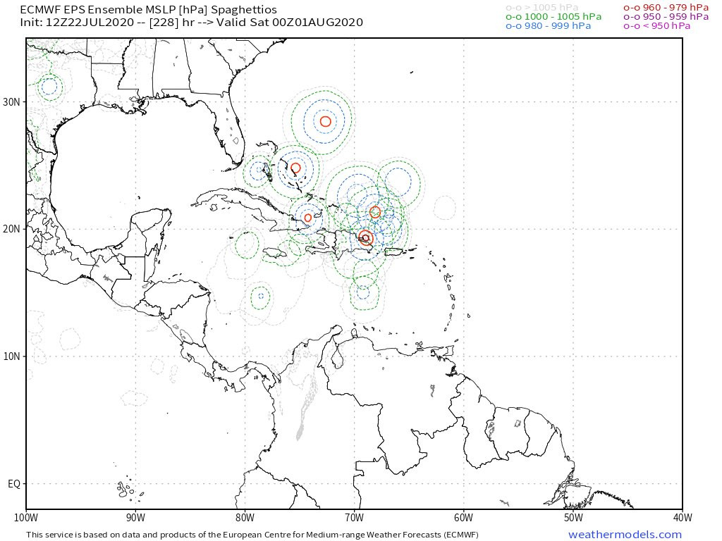
SFLcane wrote:12z EPS not done yet tracking towards Bahamas and VERY active. Irma vibes last few runs

https://iili.io/dxyxzg.jpg


Almost identical to the CMC 12z run with that potential hurricane approaching Bahamas

If this verifies and right now it has support from the CMC then this would be the dreaded “I” storm (assuming 91L develops)

Not an official forecast
3 likes   


Return to “Talkin' Tropics”

Who is online

Users browsing this forum: Google Adsense [Bot], Ian2401, Stratton23 and 54 guests