Strong Tropical Wave SSE of Cabo Verde Islands (Is Invest 92L)

This is the general tropical discussion area. Anyone can take their shot at predicting a storms path.

Moderator: S2k Moderators

Forum rules

The posts in this forum are NOT official forecasts and should not be used as such. They are just the opinion of the poster and may or may not be backed by sound meteorological data. They are NOT endorsed by any professional institution or STORM2K. For official information, please refer to products from the National Hurricane Center and National Weather Service.

Help Support Storm2K
Message
Author
User avatar
aspen
Category 5
Category 5
Posts: 8812
Joined: Sat Oct 12, 2019 7:10 pm
Location: Connecticut, USA

Re: Strong Tropical Wave emerging West Africa

#81 Postby aspen » Fri Jul 24, 2020 8:48 am

gatorcane wrote:Looks like the Euro, UKMET, and ICON show development while the GFS, CMC, and NAVGEM do not. There are a few GFS ensembles that show some weak development now but most continue to show nothing.

I see three development scenarios with this wave:

1.) it’s a low-riding Caribbean cruiser that develops in 3-5 days (00z Euro)

2.) it develops in 4-6 days and gets pulled north (Euro/EPS ensembles)

3.) it does not develop within 6 days but will track through the Caribbean and could be something to watch as it nears the west Carib/Gulf of Mexico; this could explain why the GFS and CMC aren’t showing anything as of now

Or it doesn’t develop at all and that potential STC the Euro ensembles are showing off the east coast snipes the I name.
0 likes   
Irene '11 Sandy '12 Hermine '16 5/15/2018 Derecho Fay '20 Isaias '20 Elsa '21 Henri '21 Ida '21

I am only a meteorology enthusiast who knows a decent amount about tropical cyclones. Look to the professional mets, the NHC, or your local weather office for the best information.

User avatar
PTrackerLA
Category 5
Category 5
Posts: 5276
Age: 41
Joined: Thu Oct 10, 2002 8:40 pm
Location: Lafayette, LA

Re: Strong Tropical Wave emerging West Africa

#82 Postby PTrackerLA » Fri Jul 24, 2020 9:11 am

This is going to be interesting lol

 https://twitter.com/spann/status/1286624096529391616


5 likes   

AutoPenalti
Category 5
Category 5
Posts: 4029
Age: 28
Joined: Mon Aug 17, 2015 4:16 pm
Location: Ft. Lauderdale, Florida

Re: Strong Tropical Wave emerging West Africa

#83 Postby AutoPenalti » Fri Jul 24, 2020 9:40 am

PTrackerLA wrote:This is going to be interesting lol

https://twitter.com/spann/status/1286624096529391616

and here I thought it was (aye-sae-ahs) :lol:
4 likes   
The posts in this forum are NOT official forecasts and should not be used as such. They are just the opinion of the poster and may or may not be backed by sound meteorological data. They are NOT endorsed by any professional institution or STORM2K. For official information, please refer to products from the NHC and NWS.


Model Runs Cheat Sheet:
GFS (5:30 AM/PM, 11:30 AM/PM)
HWRF, GFDL, UKMET, NAVGEM (6:30-8:00 AM/PM, 12:30-2:00 AM/PM)
ECMWF (1:45 AM/PM)

TCVN
is a weighted averaged

User avatar
EquusStorm
Category 5
Category 5
Posts: 1649
Age: 34
Joined: Thu Nov 07, 2013 1:04 pm
Location: Jasper, AL
Contact:

Re: Strong Tropical Wave SSE of Cabo Verde Islands

#84 Postby EquusStorm » Fri Jul 24, 2020 9:44 am

I mean I'm still trying to figure out the proper pronunciation of Georges from 22 years ago so :P Spanish gives me little trouble but French, ouch haha

Joaquin was another one that was widely mispronounced
Last edited by EquusStorm on Fri Jul 24, 2020 9:46 am, edited 1 time in total.
3 likes   
Colors of lost purpose on the canvas of irrelevance

Not a meteorologist, in fact more of an idiot than anything. You should probably check with the NHC or a local NWS office for official information.

User avatar
gfsperpendicular
Category 1
Category 1
Posts: 383
Age: 20
Joined: Mon Jun 19, 2017 3:04 pm
Location: Northern Virginia

Re: Strong Tropical Wave emerging West Africa

#85 Postby gfsperpendicular » Fri Jul 24, 2020 9:44 am

PTrackerLA wrote:This is going to be interesting lol

https://twitter.com/spann/status/1286624096529391616


Forget Isaias, have I been pronouncing Laura wrong all this time?
5 likes   
I'm not sleeping, I'm waiting for the 0900 UTC advisory!

#1 CMC stan

User avatar
AnnularCane
S2K Supporter
S2K Supporter
Posts: 2836
Joined: Thu Jun 08, 2006 9:18 am
Location: Wytheville, VA

Re: Strong Tropical Wave SSE of Cabo Verde Islands

#86 Postby AnnularCane » Fri Jul 24, 2020 9:47 am

They must have had several suggestions for the new I name. Surely they could have gone with one not so awkward to pronounce?

I really REALLY just want to call him Isaiah. :lol:
0 likes   

OuterBanker
S2K Supporter
S2K Supporter
Posts: 1728
Joined: Wed Feb 26, 2003 10:53 am
Location: Nags Head, NC
Contact:

Re: Strong Tropical Wave emerging West Africa

#87 Postby OuterBanker » Fri Jul 24, 2020 9:50 am

PTrackerLA wrote:This is going to be interesting lol

https://twitter.com/spann/status/1286624096529391616


I assume it's pronounced as the biblical name.

Of course we all remember Georges'

And the tsunami in Phuket Thailand (I'm sure there were a lot of newscasters saying "Uh, how do I pronounce that")
0 likes   

sma10
Category 5
Category 5
Posts: 1710
Joined: Tue Aug 02, 2005 1:13 pm

Re: Strong Tropical Wave emerging West Africa

#88 Postby sma10 » Fri Jul 24, 2020 9:58 am

PTrackerLA wrote:This is going to be interesting lol

https://twitter.com/spann/status/1286624096529391616


Yeesh. No one is going to pronounce it right
3 likes   

User avatar
Evil Jeremy
S2K Supporter
S2K Supporter
Posts: 5463
Age: 31
Joined: Mon Apr 10, 2006 2:10 pm
Location: Los Angeles, CA

Re: Strong Tropical Wave SSE of Cabo Verde Islands

#89 Postby Evil Jeremy » Fri Jul 24, 2020 10:26 am

I nominate "Ichabod" for the next replacement "I" name.

Anyway, I'm following this one closely. If it does head toward Florida, looks like it will be 10ish days from now. A long ways to go, though...
2 likes   
Frances 04 / Jeanne 04 / Katrina 05 / Wilma 05 / Fay 08 / Debby 12 / Andrea 13 / Colin 16 / Hermine 16 / Matthew 16 / Irma 17

User avatar
SFLcane
S2K Supporter
S2K Supporter
Posts: 10162
Age: 47
Joined: Sat Jun 05, 2010 1:44 pm
Location: Lake Worth Florida

Re: Strong Tropical Wave SSE of Cabo Verde Islands

#90 Postby SFLcane » Fri Jul 24, 2020 10:44 am

Evil Jeremy wrote:I nominate "Ichabod" for the next replacement "I" name.

Anyway, I'm following this one closely. If it does head toward Florida, looks like it will be 10ish days from now. A long ways to go, though...


Hey Jeremy!

Glad to see on here again. Yep this is one to watch much better moist environment surrounded it.It’s going to head west for a while.
1 likes   

User avatar
Cpv17
Category 5
Category 5
Posts: 4915
Joined: Wed Dec 07, 2016 2:24 pm
Location: Wharton/El Campo, TX

Re: Strong Tropical Wave SSE of Cabo Verde Islands

#91 Postby Cpv17 » Fri Jul 24, 2020 11:00 am

Out of all the storms going on right now this one interests me the most.
1 likes   

User avatar
Siker
Category 4
Category 4
Posts: 904
Age: 28
Joined: Thu Oct 25, 2012 7:36 pm
Location: Miami, FL

Re: Strong Tropical Wave SSE of Cabo Verde Islands

#92 Postby Siker » Fri Jul 24, 2020 11:03 am

NEW TROPICAL CYCLONE FORECAST TO DEVELOP AFTER 72 HOURS
FORECAST POSITION AT T+ 72 : 13.0N 44.6W

LEAD CENTRAL MAXIMUM WIND
VERIFYING TIME TIME POSITION PRESSURE (MB) SPEED (KNOTS)
-------------- ---- -------- ------------- -------------
1200UTC 27.07.2020 72 13.0N 44.6W 1008 31
0000UTC 28.07.2020 84 13.4N 48.8W 1007 33
1200UTC 28.07.2020 96 14.0N 53.2W 1006 35
0000UTC 29.07.2020 108 14.7N 56.9W 1004 39
1200UTC 29.07.2020 120 16.3N 60.9W 1001 42
0000UTC 30.07.2020 132 17.3N 64.7W 996 50
1200UTC 30.07.2020 144 17.9N 67.8W 993 51
1 likes   

User avatar
HurricaneAndre2008
Category 1
Category 1
Posts: 327
Age: 27
Joined: Wed Jul 31, 2019 9:51 pm
Contact:

Re: Strong Tropical Wave SSE of Cabo Verde Islands

#93 Postby HurricaneAndre2008 » Fri Jul 24, 2020 11:05 am

NEW TROPICAL STORM FORECAST TO DEVELOP AFTER 72 HOURS

FORECAST POSITION AT T+ 72 : 13.0N 44.6W


VERIFYING TIME POSITION STRENGTH TENDENCY

-------------- -------- -------- --------

12UTC 27.07.2020 13.0N 44.6W WEAK

00UTC 28.07.2020 13.4N 48.8W WEAK LITTLE CHANGE

12UTC 28.07.2020 14.0N 53.2W WEAK LITTLE CHANGE

00UTC 29.07.2020 14.7N 56.9W WEAK LITTLE CHANGE

12UTC 29.07.2020 16.3N 60.9W WEAK LITTLE CHANGE

00UTC 30.07.2020 17.3N 64.7W MODERATE INTENSIFYING SLIGHTLY

12UTC 30.07.2020 17.9N 67.8W MODERATE LITTLE CHANGE
0 likes   
Cindy(2005), Katrina(2005), Rita(2005), Erin(2007), Isaac(2012)

User avatar
gatorcane
S2K Supporter
S2K Supporter
Posts: 23689
Age: 47
Joined: Sun Mar 13, 2005 3:54 pm
Location: Boca Raton, FL

Re: Strong Tropical Wave SSE of Cabo Verde Islands

#94 Postby gatorcane » Fri Jul 24, 2020 11:05 am

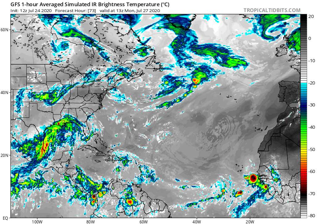
The GFS doesn’t have much left of this in a few days as you can see by the simulated IR with a few pops SW of the Cape Verde islands. The real question is once it gets to the Western Atlantic later next week into next weekend, will this wave find some favorable conditions? The GFS says there won’t be enough left of this wave while the Euro insists it will develop.

Notice also from sat imagery how this wave is heavily embedded in the SAL. I expect convection to be on the downward trend the next few days:

https://www.tropicaltidbits.com/sat/sat ... =truecolor

Image
0 likes   

User avatar
CyclonicFury
Category 5
Category 5
Posts: 2019
Age: 26
Joined: Sun Jul 02, 2017 12:32 pm
Location: NC
Contact:

Re: Strong Tropical Wave SSE of Cabo Verde Islands

#95 Postby CyclonicFury » Fri Jul 24, 2020 11:08 am

Definitely a concerning sign to see a possible CV longtracker in late July.
1 likes   
NCSU B.S. in Meteorology Class of 2021. Tropical weather blogger at http://www.cyclonicfury.com. My forecasts and thoughts are NOT official, for official forecasts please consult the National Hurricane Center.

TheStormExpert

Re: Strong Tropical Wave emerging West Africa

#96 Postby TheStormExpert » Fri Jul 24, 2020 11:11 am

SouthFLTropics wrote:
gatorcane wrote:Looks like the Euro, UKMET, and ICON show development while the GFS, CMC, and NAVGEM do not. There are a few GFS ensembles that show some weak development now but most continue to show nothing.


The way the models are acting seems completely backwards from normal. Typically the GFS and CMC would be developing everything and the Euro and UKMET would be more conservative. Not sure what the GFS and CMC aren't seeing. Every indication is that this wave is going to be a problem. Meanwhile, the NAVGEM keeps wanting to develop Gonzalo further and send it into South Florida.

I guess that's what we get with it being 2020. Nothing is normal.

2020 has been anything but a normal year so far. So for models to not act themselves or in the usual way we’re used to seeing is not a shocker to me. These models have been throwing fits since day one, just take the East Pacific for example.
3 likes   

User avatar
SouthFLTropics
Category 5
Category 5
Posts: 4236
Age: 49
Joined: Thu Aug 14, 2003 8:04 am
Location: Port St. Lucie, Florida

Re: Strong Tropical Wave SSE of Cabo Verde Islands

#97 Postby SouthFLTropics » Fri Jul 24, 2020 11:16 am

12z ICON still likes this one. 981MB on the North coast of Hispaniola in 180 hours.
0 likes   
Fourth Generation Florida Native

Personal Storm History: David 79, Andrew 92, Erin 95, Floyd 99, Irene 99, Frances 04, Jeanne 04, Wilma 05, Matthew 16, Irma 17, Ian 22, Nicole 22, Milton 24

TheStormExpert

Re: Strong Tropical Wave SSE of Cabo Verde Islands

#98 Postby TheStormExpert » Fri Jul 24, 2020 11:17 am

SFLcane wrote:
Evil Jeremy wrote:I nominate "Ichabod" for the next replacement "I" name.

Anyway, I'm following this one closely. If it does head toward Florida, looks like it will be 10ish days from now. A long ways to go, though...


Hey Jeremy!

Glad to see on here again. Yep this is one to watch much better moist environment surrounded it.It’s going to head west for a while.

This one is definitely going to have a much more favorable environment as a favorable Kelvin Wave passes. The GFS is lost in my opinion.
0 likes   

sma10
Category 5
Category 5
Posts: 1710
Joined: Tue Aug 02, 2005 1:13 pm

Re: Strong Tropical Wave SSE of Cabo Verde Islands

#99 Postby sma10 » Fri Jul 24, 2020 11:22 am

gatorcane wrote:The GFS doesn’t have much left of this in a few days as you can see by the simulated IR with a few pops SW of the Cape Verde islands. The real question is once it gets to the Western Atlantic later next week into next weekend, will this wave find some favorable conditions? The GFS says there won’t be enough left of this wave while the Euro insists it will develop.

Notice also from sat imagery how this wave is heavily embedded in the SAL. I expect convection to be on the downward trend the next few days:

https://www.tropicaltidbits.com/sat/sat ... =truecolor

https://i.postimg.cc/j5mpfcFd/gfs-ir-atl-13.png


I'm not sure the GFS performance this year fills me with confidence that it is prepared to pull a coup over the ICON/UK/EURO alliance
3 likes   

User avatar
Cpv17
Category 5
Category 5
Posts: 4915
Joined: Wed Dec 07, 2016 2:24 pm
Location: Wharton/El Campo, TX

Re: Strong Tropical Wave SSE of Cabo Verde Islands

#100 Postby Cpv17 » Fri Jul 24, 2020 11:22 am

TheStormExpert wrote:
SFLcane wrote:
Evil Jeremy wrote:I nominate "Ichabod" for the next replacement "I" name.

Anyway, I'm following this one closely. If it does head toward Florida, looks like it will be 10ish days from now. A long ways to go, though...


Hey Jeremy!

Glad to see on here again. Yep this is one to watch much better moist environment surrounded it.It’s going to head west for a while.

This one is definitely going to have a much more favorable environment as a favorable Kelvin Wave passes. The GFS is lost in my opinion.


The GFS has been lost for a while now. It can’t even see genesis till it’s already happening.
5 likes   


Return to “Talkin' Tropics”

Who is online

Users browsing this forum: No registered users and 103 guests