ATL: ISAIAS - Models
Moderator: S2k Moderators
-
Hybridstorm_November2001

- S2K Supporter

- Posts: 2817
- Joined: Sat Aug 21, 2004 2:50 pm
- Location: SW New Brunswick, Canada
- Contact:
Re: ATL: INVEST 92L - Models
I do wonder how realistic that intensity is given all the SAL that's around? I suppose we'll find out.
0 likes
-
Hybridstorm_November2001
- S2K Supporter
- Posts: 2817
- Joined: Sat Aug 21, 2004 2:50 pm
- Location: SW New Brunswick, Canada
- Contact:
Re: ATL: INVEST 92L - Models
pgoss11 wrote:
Hopefully that’s not happening. Would that be a Cat 5?
Yup, a cat 5, pressure wise.
0 likes
-
cycloneye

- Admin

- Posts: 149312
- Age: 69
- Joined: Thu Oct 10, 2002 10:54 am
- Location: San Juan, Puerto Rico
Re: ATL: INVEST 92L - Models
Hi Adrian. Do you have the link to this experimental model?
0 likes
Visit the Caribbean-Central America Weather Thread where you can find at first post web cams,radars
and observations from Caribbean basin members Click Here
and observations from Caribbean basin members Click Here
-
jlauderdal
- S2K Supporter
- Posts: 7240
- Joined: Wed May 19, 2004 5:46 am
- Location: NE Fort Lauderdale
- Contact:
Re: ATL: INVEST 92L - Models
the hwrf used to be the model we could beat up on for intensity, now its this one. the hwrf isnt afraid to go sub 940 multiple times a season, it was rarely correct.
1 likes
-
SFLcane

- S2K Supporter
- Posts: 10281
- Age: 48
- Joined: Sat Jun 05, 2010 1:44 pm
- Location: Lake Worth Florida
Re: ATL: INVEST 92L - Models
cycloneye wrote:
Hi Adrian. Do you have the link to this experimental model?
Hi my friend sure do. I am following this model since it did so well last season. It has a major hurricane 950’s just of FL coastline. We shall see.
https://storm.aoml.noaa.gov/basin/?projectName=BASIN
6 likes
-
SFLcane
- S2K Supporter
- Posts: 10281
- Age: 48
- Joined: Sat Jun 05, 2010 1:44 pm
- Location: Lake Worth Florida
Re: ATL: INVEST 92L - Models
jlauderdal wrote:
the hwrf used to be the model we could beat up on for intensity, now its this one. the hwrf isnt afraid to go sub 940 multiple times a season, it was rarely correct.
950’s is around the correct pressure.
1 likes
-
HurricaneFrances04
- Category 2

- Posts: 597
- Joined: Mon Jun 25, 2012 8:09 am
- Location: Fort Lauderdale, Florida
Re: ATL: INVEST 92L - Models
SFLcane wrote:cycloneye wrote:
Hi Adrian. Do you have the link to this experimental model?
Hi my friend sure do. I am following this model since it did so well last season. It has a major hurricane 950’s just of FL coastline. We shall see.
https://storm.aoml.noaa.gov/basin/?projectName=BASIN
Some pretty good stuff on that site, including verification images. Example: https://i.imgur.com/IvWlOv2.gif
1 likes
-
otowntiger
- Category 5

- Posts: 1932
- Joined: Tue Aug 31, 2004 7:06 pm
Re: ATL: INVEST 92L - Models
OuterBanker wrote:Until 92l slows down I don't think any model wil be accurate. Until is slows and consolidates no model will get a handle on it.
Or it may not even form, if it doesn’t slow down.
0 likes
-
Hurricaneman

- Category 5
- Posts: 7404
- Age: 45
- Joined: Tue Aug 31, 2004 3:24 pm
- Location: central florida

Re: ATL: INVEST 92L - Models
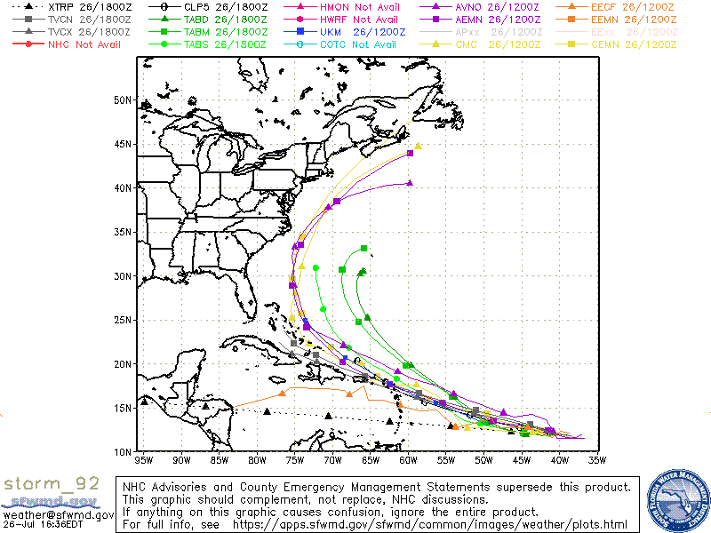
gatorcane wrote:Global models are more than capable of handling fast moving and systems that don’t have an LLC or haven’t consolidated. That is definitely a misconception some have about the models. Here are the 18Z models from SFWMD:
https://i.postimg.cc/wTPfMNd2/storm-92.gif
That's okay, I'll pass on those. At the present moment I'd be more inclined to look at the BAMS or BAMM
1 likes
Andy D
(For official information, please refer to the NHC and NWS products.)
(For official information, please refer to the NHC and NWS products.)
-
HurricaneFrances04
- Category 2
- Posts: 597
- Joined: Mon Jun 25, 2012 8:09 am
- Location: Fort Lauderdale, Florida
Re: ATL: INVEST 92L - Models
Hurricaneman wrote:At 36 hrs on the 18zGFS this is SW of 12z at 42 hrs
Another run showing weakening near the Bahamas.
0 likes
-
Evan_Wilson
- Tropical Low

- Posts: 25
- Joined: Tue May 26, 2020 1:09 pm
Re: ATL: INVEST 92L - Models
If this system develops it appears it’s going to be an absolutely massive storm, correct me if I’m wrong.
2 likes
-
Hybridstorm_November2001
- S2K Supporter
- Posts: 2817
- Joined: Sat Aug 21, 2004 2:50 pm
- Location: SW New Brunswick, Canada
- Contact:
Re: ATL: INVEST 92L - Models
Evan_Wilson wrote:If this system develops it appears it’s going to be an absolutely massive storm, correct me if I’m wrong.
You aren't wrong. It'll be a true sea monster.
0 likes

Re: ATL: INVEST 92L - Models
Hybridstorm_November2001 wrote:pgoss11 wrote:
Hopefully that’s not happening. Would that be a Cat 5?
Yup, a cat 5, pressure wise.
It would depend on ambient pressure, but it certainly seems like 926 mb would be Cat5.
1 likes
-
cycloneye
- Admin
- Posts: 149312
- Age: 69
- Joined: Thu Oct 10, 2002 10:54 am
- Location: San Juan, Puerto Rico
Re: ATL: INVEST 92L - Models
0 likes
Visit the Caribbean-Central America Weather Thread where you can find at first post web cams,radars
and observations from Caribbean basin members Click Here
and observations from Caribbean basin members Click Here
-
Hybridstorm_November2001
- S2K Supporter
- Posts: 2817
- Joined: Sat Aug 21, 2004 2:50 pm
- Location: SW New Brunswick, Canada
- Contact:
Re: ATL: INVEST 92L - Models
abajan wrote:Hybridstorm_November2001 wrote:pgoss11 wrote:Hopefully that’s not happening. Would that be a Cat 5?
Yup, a cat 5, pressure wise.
It would depend on ambient pressure, but it certainly seems like 926 mb would be Cat5.
True, storm size also plays a role in intensity. My comment was in a general sense what such a pressure might indicate.
2 likes
-
TheProfessor

- Professional-Met

- Posts: 3506
- Age: 29
- Joined: Tue Dec 03, 2013 10:56 am
- Location: Wichita, Kansas
Re: ATL: INVEST 92L - Models
18z GFS possibly beginning to change to the Euro? We'll have to watch to see if a trend develops, but obviously it's much weaker and a bit further west this run. This will definitely be a storm where the short term will decide where it goes in the long term. Where the storm begins to consolidate will be important.
2 likes
An alumnus of The Ohio State University.
Your local National Weather Service office is your best source for weather information.
Your local National Weather Service office is your best source for weather information.
-
jlauderdal
- S2K Supporter
- Posts: 7240
- Joined: Wed May 19, 2004 5:46 am
- Location: NE Fort Lauderdale
- Contact:
Re: RE: Re: ATL: INVEST 92L - Models
Typhoon Tip is the baselineHybridstorm_November2001 wrote:Evan_Wilson wrote:If this system develops it appears it’s going to be an absolutely massive storm, correct me if I’m wrong.
You aren't wrong. It'll be a true sea monster.
Sent from my SM-G973U using Tapatalk
0 likes
Re: ATL: INVEST 92L - Models
gatorcane wrote:Global models are more than capable of handling fast moving and systems that don’t have an LLC or haven’t consolidated. That is definitely a misconception some have about the models. Here are the 18Z models from SFWMD:
https://i.postimg.cc/wTPfMNd2/storm-92.gif
This is correct, and is definitely a common misconception. Having said that, the models this year, for some reason, appear to be showing more uncertainty than usual. The failure to sniff out Hanna as a viable entity 72 hrs prior to landfalling as a hurricane is just a little concerning.
1 likes
Re: RE: Re: ATL: INVEST 92L - Models
jlauderdal wrote:Typhoon Tip is the baselineHybridstorm_November2001 wrote:Evan_Wilson wrote:If this system develops it appears it’s going to be an absolutely massive storm, correct me if I’m wrong.
You aren't wrong. It'll be a true sea monster.
Sent from my SM-G973U using Tapatalk
Someone with more skills than I should overlay Tip in the Gulf of Mexico to get an idea of how enormous he was
0 likes
Who is online
Users browsing this forum: Google [Bot] and 29 guests