ATL: ISAIAS - Post-Tropical - Discussion

Moderator: S2k Moderators

Message
Author
St0rmTh0r
Category 1
Category 1
Posts: 369
Joined: Tue Jul 14, 2020 8:04 pm

Re: ATL: INVEST 92L - Discussion

#201 Postby St0rmTh0r » Sun Jul 26, 2020 8:57 pm

FireRat wrote:
Aric Dunn wrote:I must say that is one of the largest Circulations I have ever seen lol

if it ever did become a hurricane .. you better bet it would create its own environemnt

https://i.ibb.co/bXRXCn5/26038474.gif


Good lord lmao, that thing is massive! It's like the Bowser of invests, huge and likely slow to gain momentum, but once it does it would be hard to stop, like a semi truck. Dang! :eek:

Pray that doesnt come to your city wow!
0 likes   

User avatar
GeneratorPower
S2K Supporter
S2K Supporter
Posts: 1648
Age: 45
Joined: Sun Dec 18, 2005 11:48 pm
Location: Huntsville, AL

Re: ATL: INVEST 92L - Discussion

#202 Postby GeneratorPower » Sun Jul 26, 2020 9:49 pm

I’m sure everyone has heard that GOES-16 aka GOES-East is down. And specifically the imager that takes pics of the Tropical Atlantic in visible, IR, water vapor, etc. I hope they get it resolved soon because that would be a giant bummer in so many ways.

There are some suboptimal alternatives like METEOSAT but they don’t replace GOES-16. If this satellite stays out for the season we are going to have issues. 2020 strikes again.
7 likes   

User avatar
cycloneye
Admin
Admin
Posts: 145294
Age: 68
Joined: Thu Oct 10, 2002 10:54 am
Location: San Juan, Puerto Rico

Re: ATL: INVEST 92L - Discussion

#203 Postby cycloneye » Sun Jul 26, 2020 9:52 pm

2 likes   
Visit the Caribbean-Central America Weather Thread where you can find at first post web cams,radars
and observations from Caribbean basin members Click Here

User avatar
tiger_deF
Category 1
Category 1
Posts: 468
Age: 24
Joined: Tue Sep 27, 2016 11:47 am

Re: ATL: INVEST 92L - Discussion

#204 Postby tiger_deF » Sun Jul 26, 2020 9:53 pm

If the GOES blackout happened with a major storm heading near a populated area I feel like emotions would be running higher than the mild annoyance present.

92L has all the ingredients it needs to organize, now the onus is on the disturbance
4 likes   

User avatar
GeneratorPower
S2K Supporter
S2K Supporter
Posts: 1648
Age: 45
Joined: Sun Dec 18, 2005 11:48 pm
Location: Huntsville, AL

Re: ATL: INVEST 92L - Discussion

#205 Postby GeneratorPower » Sun Jul 26, 2020 9:58 pm

tiger_deF wrote:If the GOES blackout happened with a major storm heading near a populated area I feel like emotions would be running higher than the mild annoyance present.

92L has all the ingredients it needs to organize, now the onus is on the disturbance


I think any outage in hurricane season is bad news. At least with a major hurricane it would already be known pretty much where/when/how strong and we could track it with other sats and Hurricane Hunters. I think properly diagnosing 92L and getting the maximum possible advance notice of where this puppy is headed...well...that is going to be somewhat hampered by this outage. You’re right though. Either situation not good.
2 likes   

TheStormExpert

Re: ATL: INVEST 92L - Discussion

#206 Postby TheStormExpert » Sun Jul 26, 2020 10:02 pm

0 likes   

User avatar
toad strangler
S2K Supporter
S2K Supporter
Posts: 4543
Joined: Sun Jul 28, 2013 3:09 pm
Location: Earth
Contact:

Re: ATL: INVEST 92L - Discussion

#207 Postby toad strangler » Sun Jul 26, 2020 10:15 pm

TheStormExpert wrote:92L has a tough road ahead.

https://twitter.com/andyhazelton/status/1287565348359884805


huh, The National Hurricane Center says the opposite
4 likes   

User avatar
ColdMiser123
Professional-Met
Professional-Met
Posts: 904
Age: 29
Joined: Mon Sep 26, 2016 3:26 pm
Location: Northeast US

Re: ATL: INVEST 92L - Discussion

#208 Postby ColdMiser123 » Sun Jul 26, 2020 10:35 pm

There is some significant shear being forecast near the Bahamas as a result of an upper level low being present. A stronger system would theoretically be able to fend this off more compared to a weaker system, which is why intensity over the next several days will be important. Not to mention the medium range evolution itself is highly uncertain.
0 likes   
B.S., M.S., Meteorology & Atmospheric Science

IsabelaWeather
Category 1
Category 1
Posts: 287
Age: 35
Joined: Tue Jul 07, 2020 7:29 am
Location: Isabela, Puerto Rico

Re: ATL: INVEST 92L - Discussion

#209 Postby IsabelaWeather » Sun Jul 26, 2020 10:36 pm

GOES seems to be back up, 92L did some work while it was down though.
4 likes   

USTropics
Professional-Met
Professional-Met
Posts: 2650
Joined: Sun Aug 12, 2007 3:45 am
Location: Florida State University

Re: ATL: INVEST 92L - Discussion

#210 Postby USTropics » Sun Jul 26, 2020 10:37 pm

92L has one of the largest vort signature's at the low-levels I've seen for an AEW in a while, hard to believe this is July:
Image
9 likes   

User avatar
cycloneye
Admin
Admin
Posts: 145294
Age: 68
Joined: Thu Oct 10, 2002 10:54 am
Location: San Juan, Puerto Rico

Re: ATL: INVEST 92L - Discussion

#211 Postby cycloneye » Sun Jul 26, 2020 10:38 pm

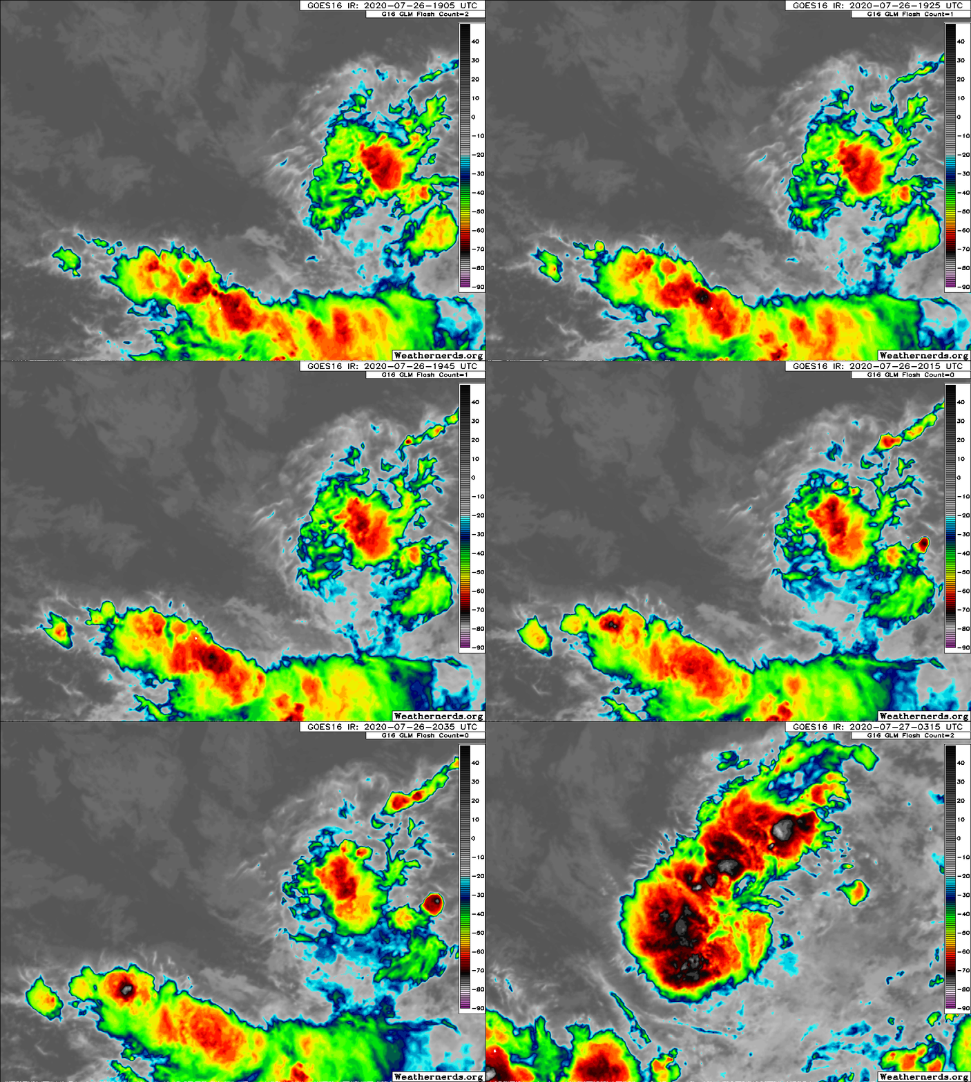
GOES-16 is back and look what has changed with 92L.

Image
9 likes   
Visit the Caribbean-Central America Weather Thread where you can find at first post web cams,radars
and observations from Caribbean basin members Click Here

User avatar
EquusStorm
Category 5
Category 5
Posts: 1649
Age: 34
Joined: Thu Nov 07, 2013 1:04 pm
Location: Jasper, AL
Contact:

Re: ATL: INVEST 92L - Discussion

#212 Postby EquusStorm » Sun Jul 26, 2020 10:43 pm

Glad that it seems to be back, what an awful time for an extended outage this woulda been
8 likes   
Colors of lost purpose on the canvas of irrelevance

Not a meteorologist, in fact more of an idiot than anything. You should probably check with the NHC or a local NWS office for official information.

User avatar
tiger_deF
Category 1
Category 1
Posts: 468
Age: 24
Joined: Tue Sep 27, 2016 11:47 am

Re: ATL: INVEST 92L - Discussion

#213 Postby tiger_deF » Sun Jul 26, 2020 10:46 pm

cycloneye wrote:GOES-16 is back and look what has changed with 92L.

https://i.imgur.com/xhh3Nhz.jpg


The fact that the convection surrounding of that area of relatively cold cloudtops has waned appreciably shows that the system is consolidating somewhat
Last edited by tiger_deF on Sun Jul 26, 2020 10:47 pm, edited 2 times in total.
1 likes   

User avatar
drezee
S2K Supporter
S2K Supporter
Posts: 3664
Joined: Mon Jun 09, 2003 12:49 pm
Location: FL

Re: ATL: INVEST 92L - Discussion

#214 Postby drezee » Sun Jul 26, 2020 10:47 pm

cycloneye wrote:GOES-16 is back and look what has changed with 92L.

https://i.imgur.com/xhh3Nhz.jpg

Need an ASCAT, but looks like consolidation near 11N
2 likes   

User avatar
gfsperpendicular
Category 1
Category 1
Posts: 383
Age: 21
Joined: Mon Jun 19, 2017 3:04 pm
Location: Northern Virginia

Re: ATL: INVEST 92L - Discussion

#215 Postby gfsperpendicular » Sun Jul 26, 2020 10:56 pm

EquusStorm wrote:Glad that it seems to be back, what an awful time for an extended outage this woulda been


It's kinda got me thinking about what would've happened in this interesting scenario. Isn't there an old GOES floating around up there somewhere? If not, between all the buoys, ascat and friends, and radars, it would probably be a much more accurate deal than the pre-satellite days.

That would be a lot of fun for the NHC forecasters, though. :lol:
2 likes   
I'm not sleeping, I'm waiting for the 0900 UTC advisory!

#1 CMC stan

User avatar
drezee
S2K Supporter
S2K Supporter
Posts: 3664
Joined: Mon Jun 09, 2003 12:49 pm
Location: FL

Re: ATL: INVEST 92L - Discussion

#216 Postby drezee » Sun Jul 26, 2020 10:58 pm

5 likes   

User avatar
blp
Category 5
Category 5
Posts: 2840
Age: 46
Joined: Thu Sep 09, 2004 7:51 pm
Location: Miami, FL
Contact:

Re: ATL: INVEST 92L - Discussion

#217 Postby blp » Sun Jul 26, 2020 11:00 pm

cycloneye wrote:GOES-16 is back and look what has changed with 92L.

https://i.imgur.com/xhh3Nhz.jpg


Yep, here the difference:

Image
10 likes   
The following post is NOT an official forecast and should not be used as such. It is just the opinion of the poster and may or may not be backed by sound meteorological data. It is NOT endorsed by any professional institution including storm2k.org For Official Information please refer to the NHC and NWS products.

User avatar
tiger_deF
Category 1
Category 1
Posts: 468
Age: 24
Joined: Tue Sep 27, 2016 11:47 am

Re: ATL: INVEST 92L - Discussion

#218 Postby tiger_deF » Sun Jul 26, 2020 11:02 pm

According to the wind radius estimates the radius of maximum winds of the system is 150 NM. That's larger than the overall size of most hurricanes I can remember outside of Sandy, and even a moderate tropical storm at this massive size might produce appreciable surge
3 likes   

User avatar
GeneratorPower
S2K Supporter
S2K Supporter
Posts: 1648
Age: 45
Joined: Sun Dec 18, 2005 11:48 pm
Location: Huntsville, AL

Re: ATL: INVEST 92L - Discussion

#219 Postby GeneratorPower » Sun Jul 26, 2020 11:03 pm

blp wrote:
cycloneye wrote:GOES-16 is back and look what has changed with 92L.

https://i.imgur.com/xhh3Nhz.jpg


Yep, here the difference:

https://uploads.disquscdn.com/images/ecdc1ec7805dabeeb7f0c46d107d66df40e5fdcecf42a184174f51c9c6f53cc3.gif

Not only do we get a mystery outage but the storm radically changes its look in those few hours. This is a bad sign. 2020 strikes again.
1 likes   

User avatar
Hammy
Category 5
Category 5
Posts: 5849
Age: 41
Joined: Fri May 25, 2012 5:25 pm
Contact:

Re: ATL: INVEST 92L - Discussion

#220 Postby Hammy » Sun Jul 26, 2020 11:07 pm

toad strangler wrote:
TheStormExpert wrote:92L has a tough road ahead.

https://twitter.com/andyhazelton/status/1287565348359884805


huh, The National Hurricane Center says the opposite


Lets wait until it's upgraded to make any claims about what they're saying about future intensity as the discussion focuses only on development chances--and it shouldn't be a very long wait given the satellite appearance.
2 likes   
The above post is not official and should not be used as such. It is the opinion of the poster and may or may not be backed by sound meteorological data. It is not endorsed by any professional institution or storm2k.org. For official information, please refer to the NHC and NWS products.


Return to “2020”

Who is online

Users browsing this forum: No registered users and 6 guests