ATL: ISAIAS - Post-Tropical - Discussion
Moderator: S2k Moderators
-
gatorcane

- S2K Supporter

- Posts: 23708
- Age: 48
- Joined: Sun Mar 13, 2005 3:54 pm
- Location: Boca Raton, FL
Re: ATL: INVEST 92L - Discussion
I will say that if 92l takes a track north of the islands and makes it into the vicinity of the Bahamas or around there without getting too disrupted by land, we could see some significant development. I am seeing some favorable conditions there possibly, a bit early to say for sure.
1 likes
-
Aric Dunn
- Category 5

- Posts: 21238
- Age: 43
- Joined: Sun Sep 19, 2004 9:58 pm
- Location: Ready for the Chase.
- Contact:
Re: ATL: INVEST 92L - Discussion
Yep that is the one we were tracking earlier on visible. It swung north now turning west .. meaning its is rotating around a larger circ to the south ... likley in that convection.
1 likes
Note: If I make a post that is brief. Please refer back to previous posts for the analysis or reasoning. I do not re-write/qoute what my initial post said each time.
If there is nothing before... then just ask
Space & Atmospheric Physicist, Embry-Riddle Aeronautical University,
I believe the sky is falling...
If there is nothing before... then just ask
Space & Atmospheric Physicist, Embry-Riddle Aeronautical University,
I believe the sky is falling...
-
SFLcane

- S2K Supporter
- Posts: 10281
- Age: 48
- Joined: Sat Jun 05, 2010 1:44 pm
- Location: Lake Worth Florida
Re: ATL: INVEST 92L - Discussion
gatorcane wrote:I will say that if 92l takes a track north of the islands and makes it into the vicinity of the Bahamas or around there without getting too disrupted by land, we could see some significant development. I am seeing some favorable conditions there possibly, a bit early to say for sure.
Hi Gatorcane, sure? No chance per HWRF paints an ugly picture. Sheared dry blob
Last edited by SFLcane on Mon Jul 27, 2020 8:29 pm, edited 1 time in total.
0 likes
-
Weatherboy1

- Category 5
- Posts: 1190
- Age: 50
- Joined: Mon Jul 05, 2004 1:50 pm
- Location: Jupiter/Sarasota, FL
Re: ATL: INVEST 92L - Discussion
Much deeper convection firing now to the W and SW of the overall circulation. As I posted earlier, expect this to be designated by tomorrow morning or maybe midday
1 likes
-
HurricaneFrances04
- Category 2

- Posts: 597
- Joined: Mon Jun 25, 2012 8:09 am
- Location: Fort Lauderdale, Florida
-
Evil Jeremy

- S2K Supporter
- Posts: 5463
- Age: 32
- Joined: Mon Apr 10, 2006 2:10 pm
- Location: Los Angeles, CA
Re: ATL: INVEST 92L - Discussion
A big swing toward the west in vorticity this evening.
5pm: https://i.ibb.co/D490YJV/5pm.gif
8pm: https://i.ibb.co/LkZkYjV/8pm.gif
Once this consolidates around the western convective mass, I think this will ramp up quickly. You can break out your shear and SAL charts, but this has sustained it's own moisture plume since Africa. It's vigorous.
5pm: https://i.ibb.co/D490YJV/5pm.gif
8pm: https://i.ibb.co/LkZkYjV/8pm.gif
Once this consolidates around the western convective mass, I think this will ramp up quickly. You can break out your shear and SAL charts, but this has sustained it's own moisture plume since Africa. It's vigorous.
Last edited by Evil Jeremy on Mon Jul 27, 2020 8:34 pm, edited 1 time in total.
4 likes
Frances 04 / Jeanne 04 / Katrina 05 / Wilma 05 / Fay 08 / Debby 12 / Andrea 13 / Colin 16 / Hermine 16 / Matthew 16 / Irma 17
-
Aric Dunn
- Category 5
- Posts: 21238
- Age: 43
- Joined: Sun Sep 19, 2004 9:58 pm
- Location: Ready for the Chase.
- Contact:
Re: ATL: INVEST 92L - Discussion
new ASCAT. a little elongated still but much more defined than this mornings ASCAT
the SW Lobe does appears to be consolidating under the convection.

the SW Lobe does appears to be consolidating under the convection.
5 likes
Note: If I make a post that is brief. Please refer back to previous posts for the analysis or reasoning. I do not re-write/qoute what my initial post said each time.
If there is nothing before... then just ask
Space & Atmospheric Physicist, Embry-Riddle Aeronautical University,
I believe the sky is falling...
If there is nothing before... then just ask
Space & Atmospheric Physicist, Embry-Riddle Aeronautical University,
I believe the sky is falling...

Re: ATL: INVEST 92L - Discussion
I believe we'll be looking at a T.S. approaching the ROCK late Thursday
1 likes
Andy D
(For official information, please refer to the NHC and NWS products.)
(For official information, please refer to the NHC and NWS products.)
-
gatorcane
- S2K Supporter
- Posts: 23708
- Age: 48
- Joined: Sun Mar 13, 2005 3:54 pm
- Location: Boca Raton, FL
Re: ATL: INVEST 92L - Discussion
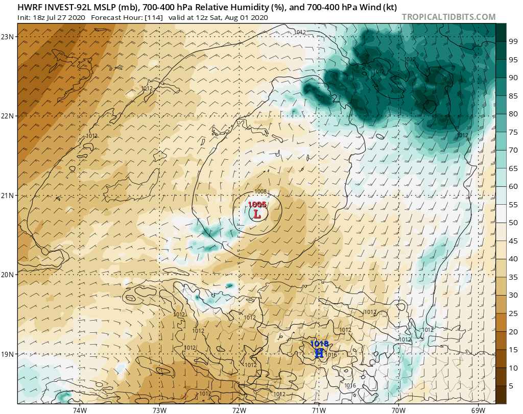
SFLcane wrote:gatorcane wrote:I will say that if 92l takes a track north of the islands and makes it into the vicinity of the Bahamas or around there without getting too disrupted by land, we could see some significant development. I am seeing some favorable conditions there possibly, a bit early to say for sure.
Hi Gatorcane, sure? No chance per HWRF paints an ugly picture. Sheared dry blob
https://iili.io/dusJ0N.png
If 92l can build a solid core and is a storm heading into that area, it could probably fend off the SAL given the system’s large size with ideal upper-level winds and high SSTs. See GFS parallel as an example. That model does look a bit too bullish in the short to medium term though.
3 likes


Re: ATL: INVEST 92L - Discussion
SFLcane wrote:gatorcane wrote:I will say that if 92l takes a track north of the islands and makes it into the vicinity of the Bahamas or around there without getting too disrupted by land, we could see some significant development. I am seeing some favorable conditions there possibly, a bit early to say for sure.
Hi Gatorcane, sure? No chance per HWRF paints an ugly picture. Sheared dry blob
https://iili.io/dusJ0N.png
The euro is showing a lot of dry air from the SAL getting sucked in the high pressure lobe to the north of 92l.
It then carries it across the Atlantic with it towards the Bahamas and east coast.
I think 92l's best chance for significant development is if the southern lobe consolidates and tracks south into the Caribbean where it's more moist and more favorable wind shear according to the euro.
2 likes
-
Aric Dunn
- Category 5
- Posts: 21238
- Age: 43
- Joined: Sun Sep 19, 2004 9:58 pm
- Location: Ready for the Chase.
- Contact:
Re: ATL: INVEST 92L - Discussion
STRiZZY wrote:SFLcane wrote:gatorcane wrote:I will say that if 92l takes a track north of the islands and makes it into the vicinity of the Bahamas or around there without getting too disrupted by land, we could see some significant development. I am seeing some favorable conditions there possibly, a bit early to say for sure.
Hi Gatorcane, sure? No chance per HWRF paints an ugly picture. Sheared dry blob
https://iili.io/dusJ0N.png
The euro is showing a lot of dry air from the SAL getting sucked in the high pressure lobe to the north of 92l.
It then carries it across the Atlantic with it towards the Bahamas and east coast.
I think 92l's best chance for significant development is if the southern lobe consolidates and tracks south into the Caribbean where it's more moist and more favorable wind shear according to the euro.
Which is weird.. becasue it pretty much ATE the entire SAL plume today lol
Cut the plume in half..
Models are likely way off on the dry air issue.. especially given its current state of not having moisture issues.
6 likes
Note: If I make a post that is brief. Please refer back to previous posts for the analysis or reasoning. I do not re-write/qoute what my initial post said each time.
If there is nothing before... then just ask
Space & Atmospheric Physicist, Embry-Riddle Aeronautical University,
I believe the sky is falling...
If there is nothing before... then just ask
Space & Atmospheric Physicist, Embry-Riddle Aeronautical University,
I believe the sky is falling...

Re: ATL: INVEST 92L - Discussion
Can anyone think of another invest that looked even remotely like this one in this location? Not only is it absolutely massive, but it has a vigor that I've never seen, and has been tapping into moisture streams all the way from the equator. With the current climatology and amount of dry air that was around this system, I think that any smaller wave would have been completely consumed.
1 likes
Re: ATL: INVEST 92L - Discussion
STRiZZY wrote:SFLcane wrote:gatorcane wrote:I will say that if 92l takes a track north of the islands and makes it into the vicinity of the Bahamas or around there without getting too disrupted by land, we could see some significant development. I am seeing some favorable conditions there possibly, a bit early to say for sure.
Hi Gatorcane, sure? No chance per HWRF paints an ugly picture. Sheared dry blob
https://iili.io/dusJ0N.png
The euro is showing a lot of dry air from the SAL getting sucked in the high pressure lobe to the north of 92l.
It then carries it across the Atlantic with it towards the Bahamas and east coast.
I think 92l's best chance for significant development is if the southern lobe consolidates and tracks south into the Caribbean where it's more moist and more favorable wind shear according to the euro.
This would be a very interesting solution, one not yet shown by any model. I imagine given the complexity, that it's possible for all models to bust. The question would be, what track would it most likely take? Towards Yucatan I guess?
2 likes
-
SouthFloridawx

- S2K Supporter
- Posts: 8346
- Age: 47
- Joined: Tue Jul 26, 2005 1:16 am
- Location: Sarasota, FL
- Contact:
Re: ATL: INVEST 92L - Discussion
It's a large system. It'll take a little time to get going. 
Sent from my SM-G981U using Tapatalk
Sent from my SM-G981U using Tapatalk
6 likes
Re: ATL: INVEST 92L - Discussion
Aric Dunn wrote:STRiZZY wrote:SFLcane wrote:
Hi Gatorcane, sure? No chance per HWRF paints an ugly picture. Sheared dry blob
https://iili.io/dusJ0N.png
The euro is showing a lot of dry air from the SAL getting sucked in the high pressure lobe to the north of 92l.
It then carries it across the Atlantic with it towards the Bahamas and east coast.
I think 92l's best chance for significant development is if the southern lobe consolidates and tracks south into the Caribbean where it's more moist and more favorable wind shear according to the euro.
Which is weird.. becasue it pretty much ATE the entire SAL plume today lol
Cut the plume in half..
Models are likely way off on the dry air issue.. especially given its current state of not having moisture issues.
Pretty dry to the north of 92l. That's probably why the convection to the south is more robust.

6 likes
Re: ATL: INVEST 92L - Discussion
sma10 wrote:STRiZZY wrote:SFLcane wrote:
Hi Gatorcane, sure? No chance per HWRF paints an ugly picture. Sheared dry blob
https://iili.io/dusJ0N.png
The euro is showing a lot of dry air from the SAL getting sucked in the high pressure lobe to the north of 92l.
It then carries it across the Atlantic with it towards the Bahamas and east coast.
I think 92l's best chance for significant development is if the southern lobe consolidates and tracks south into the Caribbean where it's more moist and more favorable wind shear according to the euro.
This would be a very interesting solution, one not yet shown by any model. I imagine given the complexity, that it's possible for all models to bust. The question would be, what track would it most likely take? Towards Yucatan I guess?
I would assume it would track pretty similar to the 0z from the 24th (which is where this idea came from) which was into the Yucatan Channel. From there I'm not sure.
There looks to be two lobes of high pressure to the north of it at that time and I would figure it squeeze between them perhaps towards the northern Gulf coast.
0 likes
-
Aric Dunn
- Category 5
- Posts: 21238
- Age: 43
- Joined: Sun Sep 19, 2004 9:58 pm
- Location: Ready for the Chase.
- Contact:
Re: ATL: INVEST 92L - Discussion
STRiZZY wrote:Aric Dunn wrote:STRiZZY wrote:
The euro is showing a lot of dry air from the SAL getting sucked in the high pressure lobe to the north of 92l.
It then carries it across the Atlantic with it towards the Bahamas and east coast.
I think 92l's best chance for significant development is if the southern lobe consolidates and tracks south into the Caribbean where it's more moist and more favorable wind shear according to the euro.
Which is weird.. becasue it pretty much ATE the entire SAL plume today lol
Cut the plume in half..
Models are likely way off on the dry air issue.. especially given its current state of not having moisture issues.
Pretty dry to the north of 92l. That's probably why the convection to the south is more robust.
http://tropic.ssec.wisc.edu/real-time/sal/g16split/g16split.jpg
It has a massive moisture feed and very large buffer zone from what is left of the SAL ( these images are pretty bad sometimes). COnvection building well up the east side and to the north side as the moisture flux pushes north.
4 likes
Note: If I make a post that is brief. Please refer back to previous posts for the analysis or reasoning. I do not re-write/qoute what my initial post said each time.
If there is nothing before... then just ask
Space & Atmospheric Physicist, Embry-Riddle Aeronautical University,
I believe the sky is falling...
If there is nothing before... then just ask
Space & Atmospheric Physicist, Embry-Riddle Aeronautical University,
I believe the sky is falling...
-
ScottNAtlanta

- Category 5
- Posts: 2535
- Joined: Sat May 25, 2013 3:11 pm
- Location: Atlanta, GA
Re: ATL: INVEST 92L - Discussion
The way this is barreling west...I dont see it gaining much latitude, The 18z GFS starts to develop the southern lobe and at 36 hours just kills it and develops the northern lobe which makes zero sense.
0 likes
The posts in this forum are NOT official forecast and should not be used as such. They are just the opinion of the poster and may or may not be backed by sound meteorological data. They are NOT endorsed by any professional institution or storm2k.org. For official information, please refer to the NHC and NWS products.
-
CourierPR

- Category 5
- Posts: 1336
- Age: 72
- Joined: Tue Aug 31, 2004 7:53 pm
- Location: Pompano Beach, Florida
Re: ATL: INVEST 92L - Discussion
tiger_deF wrote:Can anyone think of another invest that looked even remotely like this one in this location? Not only is it absolutely massive, but it has a vigor that I've never seen, and has been tapping into moisture streams all the way from the equator. With the current climatology and amount of dry air that was around this system, I think that any smaller wave would have been completely consumed.
Climatology is the scientific study of climate (= general or long-term weather conditions) The last part of the definition is key--General or long-term weather conditions. Climatology is not a force unto itself and using the phrase "current climatology" is a misnomer.
3 likes
-
eastcoastFL

- Category 5
- Posts: 3996
- Age: 44
- Joined: Thu Apr 12, 2007 12:29 pm
- Location: Palm City, FL
Re: ATL: INVEST 92L - Discussion
Cold tops firing off right now. 92L seems to be making a move tonight.

1 likes
Personal Forecast Disclaimer:
The posts in this forum are NOT official forecast and should not be used as such. They are just the opinion of the poster and may or may not be backed by sound meteorological data. They are NOT endorsed by any professional institution or storm2k.org. For official information, please refer to the NHC and NWS products.
The posts in this forum are NOT official forecast and should not be used as such. They are just the opinion of the poster and may or may not be backed by sound meteorological data. They are NOT endorsed by any professional institution or storm2k.org. For official information, please refer to the NHC and NWS products.
Who is online
Users browsing this forum: No registered users and 31 guests