ATL: ISAIAS - Post-Tropical - Discussion

Moderator: S2k Moderators

Message
Author
User avatar
tiger_deF
Category 1
Category 1
Posts: 468
Age: 24
Joined: Tue Sep 27, 2016 11:47 am

Re: ATL: NINE - Potential Tropical Cyclone - Discussion

#801 Postby tiger_deF » Tue Jul 28, 2020 1:11 pm

ConvergenceZone wrote:
OuterBanker wrote:Most models have shifted west and with only a tropical storm which is good news for us.
Now we are at 100% capacity, nothing available. National news is telling people it is a safe beach.
And the tourist came.
As long as the hype for the storm is aimed at someone else we will thrive.


Hoping it stays that way, to try to evac the OBX at full capacity would be a nightmare.


Remember not to pay attention to strength forecasts, as they will more than likely be wrong. I think the strength forecasts will definitely go up slowly.


I absolutely agree, and I think the current intensity guidance is also factoring in the fact that the disturbance might not form into anything at all or get shredded up by land interaction with the larger islands of the Antilles. If 92L does form into a definitive tropical storm than I think the guidance will go up reflecting that.
0 likes   

User avatar
aspen
Category 5
Category 5
Posts: 8818
Joined: Sat Oct 12, 2019 7:10 pm
Location: Connecticut, USA

Re: ATL: NINE - Potential Tropical Cyclone - Discussion

#802 Postby aspen » Tue Jul 28, 2020 1:12 pm

Vdogg wrote:
OuterBanker wrote:Most models have shifted west and with only a tropical storm which is good news for us.
Now we are at 100% capacity, nothing available. National news is telling people it is a safe beach.
And the tourist came.
As long as the hype for the storm is aimed at someone else we will thrive.
Hoping it stays that way, to try to evac the OBX at full capacity would be a nightmare.

I’m getting Irene vibes off this but too early to tell for now.

I was getting Irene vibes until the last 12-24 hours, with most of the globals becoming tame with intensity and trending towards a storm that recurves far later. Doesn’t seem like PTC-9 will be an East Coast Sweep like Irene or Gloria. I’m thinking there’s a better chance of this making it into the far eastern Gulf like Irma.
3 likes   
Irene '11 Sandy '12 Hermine '16 5/15/2018 Derecho Fay '20 Isaias '20 Elsa '21 Henri '21 Ida '21

I am only a meteorology enthusiast who knows a decent amount about tropical cyclones. Look to the professional mets, the NHC, or your local weather office for the best information.

RT23
Tropical Depression
Tropical Depression
Posts: 65
Joined: Thu Sep 07, 2017 2:21 pm

Re: ATL: NINE - Potential Tropical Cyclone - Discussion

#803 Postby RT23 » Tue Jul 28, 2020 1:12 pm

ColdMiser123 wrote:Recon finding no signs of rotation with the northeast lobe, which shows that the southwest lobe has conclusively become the dominant piece of this disturbance, and any spin there has become washed out with the wind flow. They are turning away from the northeast lobe.


Would love them to investigate that area of vort east of Barbados
3 likes   

caribsue
Tropical Depression
Tropical Depression
Posts: 96
Joined: Mon Jul 14, 2008 3:54 pm
Location: Barbados

Re: ATL: NINE - Potential Tropical Cyclone - Discussion

#804 Postby caribsue » Tue Jul 28, 2020 1:16 pm

RT23 wrote:
ColdMiser123 wrote:Recon finding no signs of rotation with the northeast lobe, which shows that the southwest lobe has conclusively become the dominant piece of this disturbance, and any spin there has become washed out with the wind flow. They are turning away from the northeast lobe.


Would love them to investigate that area of vort east of Barbados


Indeed as we are now experiencing heavy rains and hearing thunder on the south coast
4 likes   

Chemmers
Tropical Storm
Tropical Storm
Posts: 220
Joined: Wed Jul 22, 2020 6:16 am

Re: ATL: NINE - Potential Tropical Cyclone - Discussion

#805 Postby Chemmers » Tue Jul 28, 2020 1:17 pm

I think it will be cat 1 maybe 2 by the time it get close to Florida
2 likes   

User avatar
weathaguyry
Category 5
Category 5
Posts: 1272
Age: 22
Joined: Wed Jun 15, 2016 5:16 am
Location: Long Island, NY

Re: ATL: NINE - Potential Tropical Cyclone - Discussion

#806 Postby weathaguyry » Tue Jul 28, 2020 1:18 pm

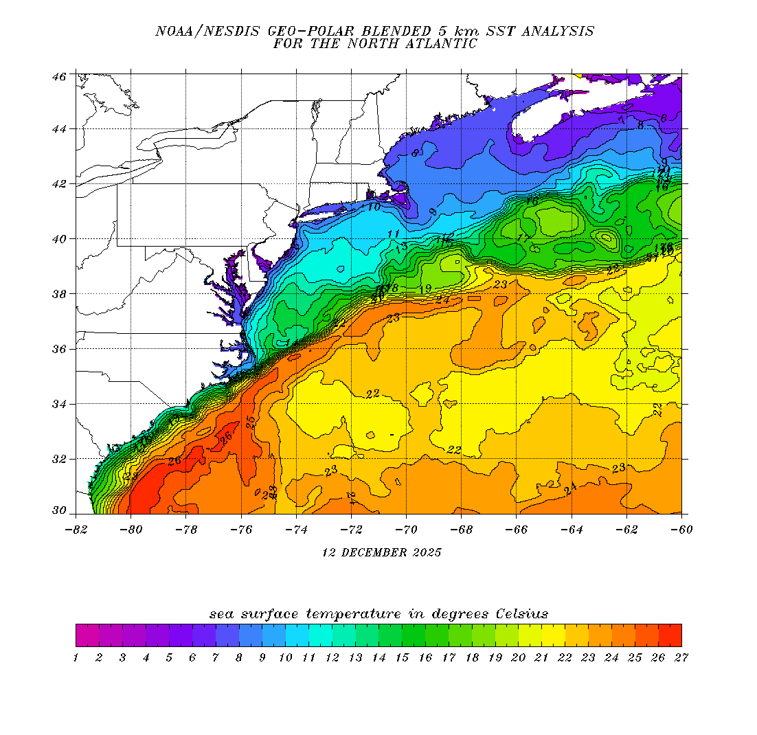
The storm will more than likely stay weak and disorganized as it goes through the Caribbean because of land interaction, shear, and dry air. However, I’m concerned about what happens after it starts moving north along the east coast like some models are showing. Waters are extremely warm, with a large area of 26C anomalies stretching all the way to New York :eek:

Image
5 likes   
My posts are only my opinions and NOT official forecasts. For official forecasts, consult the National Hurricane Center or the National Weather Service.

Irene 11', Sandy 12', Fay 20’, Isaias 20’, Elsa 21’, Henri 21’, Ida 21’

User avatar
MGC
S2K Supporter
S2K Supporter
Posts: 5899
Joined: Sun Mar 23, 2003 9:05 pm
Location: Pass Christian MS, or what is left.

Re: ATL: NINE - Potential Tropical Cyclone - Discussion

#807 Postby MGC » Tue Jul 28, 2020 1:23 pm

Should have a tighter circulation tomorrow. Still moving westward too quickly. NHC will likely have to move the forecast track to the left if this continues......MGC
5 likes   

Do_For_Love
Category 1
Category 1
Posts: 271
Age: 35
Joined: Sat May 09, 2015 7:47 am
Location: Delaware

Re: ATL: NINE - Potential Tropical Cyclone - Discussion

#808 Postby Do_For_Love » Tue Jul 28, 2020 1:24 pm

Yeah that's a good point. If it does ending up tracking the east coast I would be keeping an eye on it myself. We already had Fay go over us this year...
3 likes   
Irene '11, Sandy '12, Fay '20, Isaias '20, Ida '21

TallyTracker
Category 2
Category 2
Posts: 734
Joined: Thu Oct 11, 2018 2:46 pm

Re: ATL: NINE - Potential Tropical Cyclone - Discussion

#809 Postby TallyTracker » Tue Jul 28, 2020 1:26 pm

I certainly don’t want to see this storm get into the Gulf. I was just down at St. George Island on Saturday night to view the comet. The waters are extremely warm and primed for potentially intense storms. Hanna has cleared out the dry air and left a very moist unstable atmosphere. If the upper level winds are low, this could become a significant hurricane.
1 likes   
Fran '96, Georges '98, Gordon '00, Gabrielle '01, Charley '04, Frances '04, Jeanne '04, Barry '07, Fay '08, Debby '12, Matthew '16, Emily '17, Irma '17, Michael ‘18, Elsa ‘21, Fred ‘21, Mindy ‘21, Nicole ‘22, Idalia ‘23, Debby ‘24, Helene ‘24

User avatar
Weatherboy1
Category 5
Category 5
Posts: 1189
Age: 49
Joined: Mon Jul 05, 2004 1:50 pm
Location: Jupiter/Sarasota, FL

Re: ATL: NINE - Potential Tropical Cyclone - Discussion

#810 Postby Weatherboy1 » Tue Jul 28, 2020 1:27 pm

Euro still liking a path south of FL/through the straits into the SE Gulf. Other models showing a SE FL hit and/or skirting just east of the coast. That spread between far SW and NE models is going to narrow in the next 24 hours or so, and hopefully we'll have a better idea if this Gulf bound, FL bound, or farther up the east coast. Always tough when you have a system approaching from this particular angle
1 likes   

User avatar
aspen
Category 5
Category 5
Posts: 8818
Joined: Sat Oct 12, 2019 7:10 pm
Location: Connecticut, USA

Re: ATL: NINE - Potential Tropical Cyclone - Discussion

#811 Postby aspen » Tue Jul 28, 2020 1:28 pm

weathaguyry wrote:The storm will more than likely stay weak and disorganized as it goes through the Caribbean because of land interaction, shear, and dry air. However, I’m concerned about what happens after it starts moving north along the east coast like some models are showing. Waters are extremely warm, with a large area of 26C anomalies stretching all the way to New York :eek:

https://www.ospo.noaa.gov/data/sst/contour/natlanti.fc.gif

Some parts of the southern Gulf Stream are getting close to 31 C. PTC-9 could potentially become a hurricane in that region assuming it already has a decent structure, but based on today’s model runs, it’s looking less likely it’ll try for an East Coast Sweep path through the Gulf Stream.
1 likes   
Irene '11 Sandy '12 Hermine '16 5/15/2018 Derecho Fay '20 Isaias '20 Elsa '21 Henri '21 Ida '21

I am only a meteorology enthusiast who knows a decent amount about tropical cyclones. Look to the professional mets, the NHC, or your local weather office for the best information.

User avatar
NDG
S2K Supporter
S2K Supporter
Posts: 15446
Joined: Sun Jul 09, 2006 10:14 pm
Location: Orlando, FL

Re: ATL: NINE - Potential Tropical Cyclone - Discussion

#812 Postby NDG » Tue Jul 28, 2020 1:35 pm

I don't think recon will find a well defined LLC this afternoon, that vorticity east of Barbados is clear not at the surface by looking at the radar from Barbados.
1 likes   

User avatar
storm_in_a_teacup
Category 1
Category 1
Posts: 421
Joined: Wed Aug 16, 2017 5:01 pm
Location: Huntsville, Alabama (originally from Houston)
Contact:

Re: ATL: NINE - Potential Tropical Cyclone - Discussion

#813 Postby storm_in_a_teacup » Tue Jul 28, 2020 1:40 pm

Sorry for being a little out of the loop but...

Earlier in this thread I saw people saying this system’s large size would give it an edge on surviving the dry air around it.

However in an active storm thread last year (don’t remember which one) 1900hurricane said that larger systems have a tendency to draw in dry air from far away and damage themselves with that.

So...do smaller or larger systems have an advantage when it comes to surviving dry air, or does it depend on the situation?
0 likes   
I know I can't straddle the atmosphere...just a tiny storm in your teacup, girl.

User avatar
wzrgirl1
S2K Supporter
S2K Supporter
Posts: 1325
Joined: Sat Sep 04, 2004 6:44 am
Location: Pembroke Pines, Florida

Re: ATL: NINE - Potential Tropical Cyclone - Discussion

#814 Postby wzrgirl1 » Tue Jul 28, 2020 1:41 pm

For the reconnaissance data I am able to figure out most of it including directional heading, coordinates, wind speeds, etc. however does anyone have a link to a more detailed description. Thanks!
1 likes   

User avatar
northjaxpro
S2K Supporter
S2K Supporter
Posts: 8900
Joined: Mon Sep 27, 2010 11:21 am
Location: Jacksonville, FL

Re: ATL: NINE - Potential Tropical Cyclone - Discussion

#815 Postby northjaxpro » Tue Jul 28, 2020 1:43 pm

aspen wrote:
Vdogg wrote:
OuterBanker wrote:Most models have shifted west and with only a tropical storm which is good news for us.
Now we are at 100% capacity, nothing available. National news is telling people it is a safe beach.
And the tourist came.
As long as the hype for the storm is aimed at someone else we will thrive.
Hoping it stays that way, to try to evac the OBX at full capacity would be a nightmare.

I’m getting Irene vibes off this but too early to tell for now.

I was getting Irene vibes until the last 12-24 hours, with most of the globals becoming tame with intensity and trending towards a storm that recurves far later. Doesn’t seem like PTC-9 will be an East Coast Sweep like Irene or Gloria. I’m thinking there’s a better chance of this making it into the far eastern Gulf like Irma.

Yes, this is my.line of thinking at this juncture currently.
0 likes   
NEVER, EVER SAY NEVER in the tropics and weather in general, and most importantly, with life itself!!

________________________________________________________________________________________

Fay 2008 Beryl 2012 Debby 2012 Colin 2016 Hermine 2016 Julia 2016 Matthew 2016 Irma 2017 Dorian 2019

User avatar
chaser1
S2K Supporter
S2K Supporter
Posts: 5472
Age: 64
Joined: Sat Oct 15, 2005 5:59 pm
Location: Longwood, Fl

Re: ATL: NINE - Potential Tropical Cyclone - Discussion

#816 Postby chaser1 » Tue Jul 28, 2020 1:44 pm

OuterBanker wrote:Most models have shifted west and with only a tropical storm which is good news for us.
Now we are at 100% capacity, nothing available. National news is telling people it is a safe beach.
And the tourist came.
As long as the hype for the storm is aimed at someone else we will thrive.
Hoping it stays that way, to try to evac the OBX at full capacity would be a nightmare.


Tourist? Safe beach? 100% capacity? Can you toss in a couple additional nouns & verbs? Good news for who?
1 likes   
Andy D

(For official information, please refer to the NHC and NWS products.)

User avatar
wxman57
Moderator-Pro Met
Moderator-Pro Met
Posts: 22979
Age: 67
Joined: Sat Jun 21, 2003 8:06 pm
Location: Houston, TX (southwest)

Re: ATL: NINE - Potential Tropical Cyclone - Discussion

#817 Postby wxman57 » Tue Jul 28, 2020 1:46 pm

Chemmers wrote:I think it will be cat 1 maybe 2 by the time it get close to Florida


Based on what? You should include the disclaimer saying that you are not a meteorologist when making such claims.
7 likes   

AutoPenalti
Category 5
Category 5
Posts: 4030
Age: 29
Joined: Mon Aug 17, 2015 4:16 pm
Location: Ft. Lauderdale, Florida

Re: ATL: NINE - Potential Tropical Cyclone - Discussion

#818 Postby AutoPenalti » Tue Jul 28, 2020 1:47 pm

wxman57 wrote:
Chemmers wrote:I think it will be cat 1 maybe 2 by the time it get close to Florida


Based on what?

Can't you read silly goose, based on his thinking of course. :lol:
6 likes   
The posts in this forum are NOT official forecasts and should not be used as such. They are just the opinion of the poster and may or may not be backed by sound meteorological data. They are NOT endorsed by any professional institution or STORM2K. For official information, please refer to products from the NHC and NWS.


Model Runs Cheat Sheet:
GFS (5:30 AM/PM, 11:30 AM/PM)
HWRF, GFDL, UKMET, NAVGEM (6:30-8:00 AM/PM, 12:30-2:00 AM/PM)
ECMWF (1:45 AM/PM)

TCVN
is a weighted averaged

User avatar
ColdMiser123
Professional-Met
Professional-Met
Posts: 904
Age: 29
Joined: Mon Sep 26, 2016 3:26 pm
Location: Northeast US

Re: ATL: NINE - Potential Tropical Cyclone - Discussion

#819 Postby ColdMiser123 » Tue Jul 28, 2020 1:49 pm

wzrgirl1 wrote:For the reconnaissance data I am able to figure out most of it including directional heading, coordinates, wind speeds, etc. however does anyone have a link to a more detailed description. Thanks!


https://www.ofcm.gov/publications/nhop/2020_nhop.pdf

Page 134 has a decoder for the data recon puts out.
3 likes   
B.S., M.S., Meteorology & Atmospheric Science

User avatar
msbee
S2K Supporter
S2K Supporter
Posts: 3027
Joined: Wed Jun 11, 2003 10:11 am
Location: St. Maarten

Re: ATL: NINE - Potential Tropical Cyclone - Discussion

#820 Postby msbee » Tue Jul 28, 2020 1:53 pm

thanks for everyone's analyses and opinions and updates.
But now I have a question. I have a cockatoo outside in a big aviary. think I should put him in his small cage and bring him into the house tonight? when will the wind and rain start on St. Maarten? #thingsIworryabout :lol:
0 likes   
Too many hurricanes to remember


Return to “2020”

Who is online

Users browsing this forum: No registered users and 9 guests