ATL: ISAIAS - Models
Moderator: S2k Moderators

Re: ATL: ISAIAS - Models
I am seeing a subtle short term expansion of the ridge to the east; a combination of this along with a somewhat sheared environment and mitigated inflow, would appear to bump the storm a bit more westerly then prior TVCN runs have suggested. I see surface convergence improving as the storm gains a bit more latitude however that might allow it to put back a little more "meat on it's bones". I think the storm will hold it's own but there might be the possibility of slight weakening as it approaches closer to the Florida coastline. My guess is that NHC will pull the "Warning" card for portions of the current Watch area and possibly increase the T.S. Watch to a Hurricane Watch. I think that NHC has little choice other then follow a west shift that models project, at least as a precautionary move.
5 likes
Andy D
(For official information, please refer to the NHC and NWS products.)
(For official information, please refer to the NHC and NWS products.)
Re: ATL: ISAIAS - Models
Don't know if anyone mentioned but NAM (I know I know) has landfall in Palm Beach County after being offshore for the past several runs

6z NAVGEM has landfall in the Upper Keys similar to the CMC

6z NAVGEM has landfall in the Upper Keys similar to the CMC
0 likes
-
chris_fit

- Category 5

- Posts: 3261
- Age: 43
- Joined: Wed Sep 10, 2003 11:58 pm
- Location: Tampa Bay Area, FL
Re: ATL: ISAIAS - Models
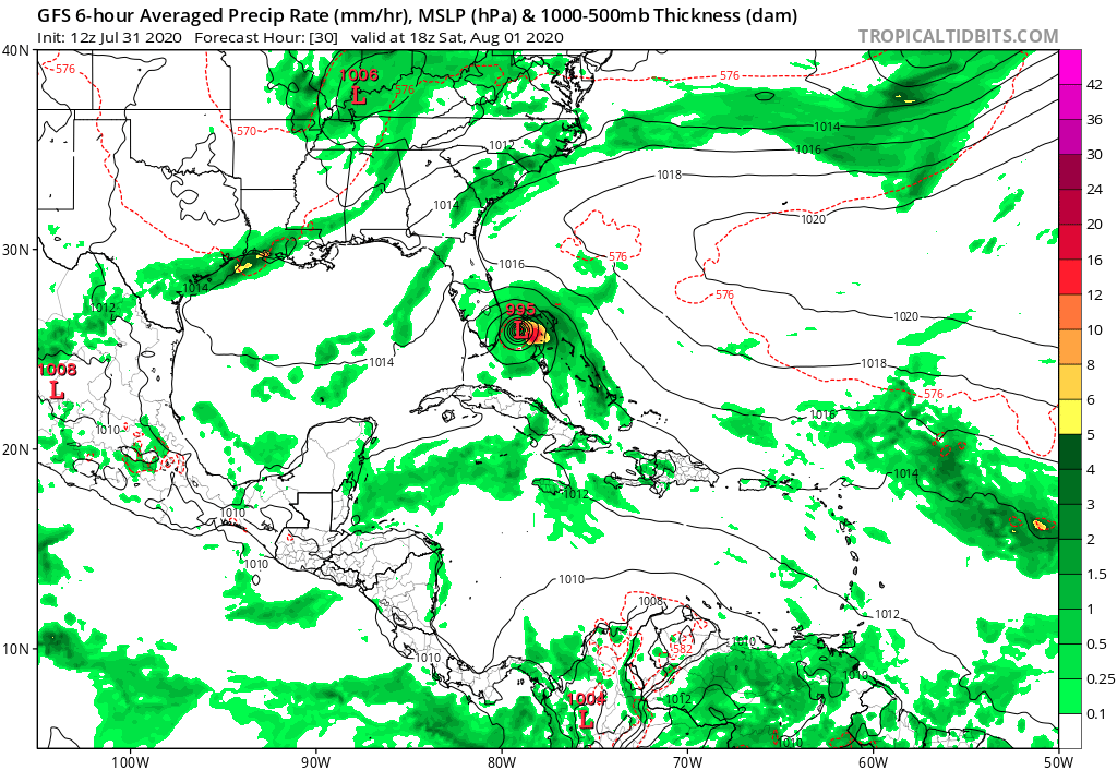
12Z Models gonna start rolling in soon - Gonna be an important suite of runs to see if the Westward shifts coninue.
1 likes
-
gatorcane

- S2K Supporter

- Posts: 23708
- Age: 48
- Joined: Sun Mar 13, 2005 3:54 pm
- Location: Boca Raton, FL
Re: ATL: ISAIAS - Models
A little stronger a slightly more west on the 12Z GFS through 18 hours 
0 likes

Re: ATL: ISAIAS - Models
Chances for a direct hit by Isaias in FL are going up with the GFS trending westward. IMO.
0 likes
-
gatorcane
- S2K Supporter
- Posts: 23708
- Age: 48
- Joined: Sun Mar 13, 2005 3:54 pm
- Location: Boca Raton, FL
Re: ATL: ISAIAS - Models
Landfall a little south of Melbourne?
Last edited by gatorcane on Fri Jul 31, 2020 10:43 am, edited 2 times in total.
0 likes
-
WeatherEmperor
- S2K Supporter
- Posts: 4806
- Age: 41
- Joined: Thu Sep 04, 2003 2:54 pm
- Location: South Florida
Re: ATL: ISAIAS - Models
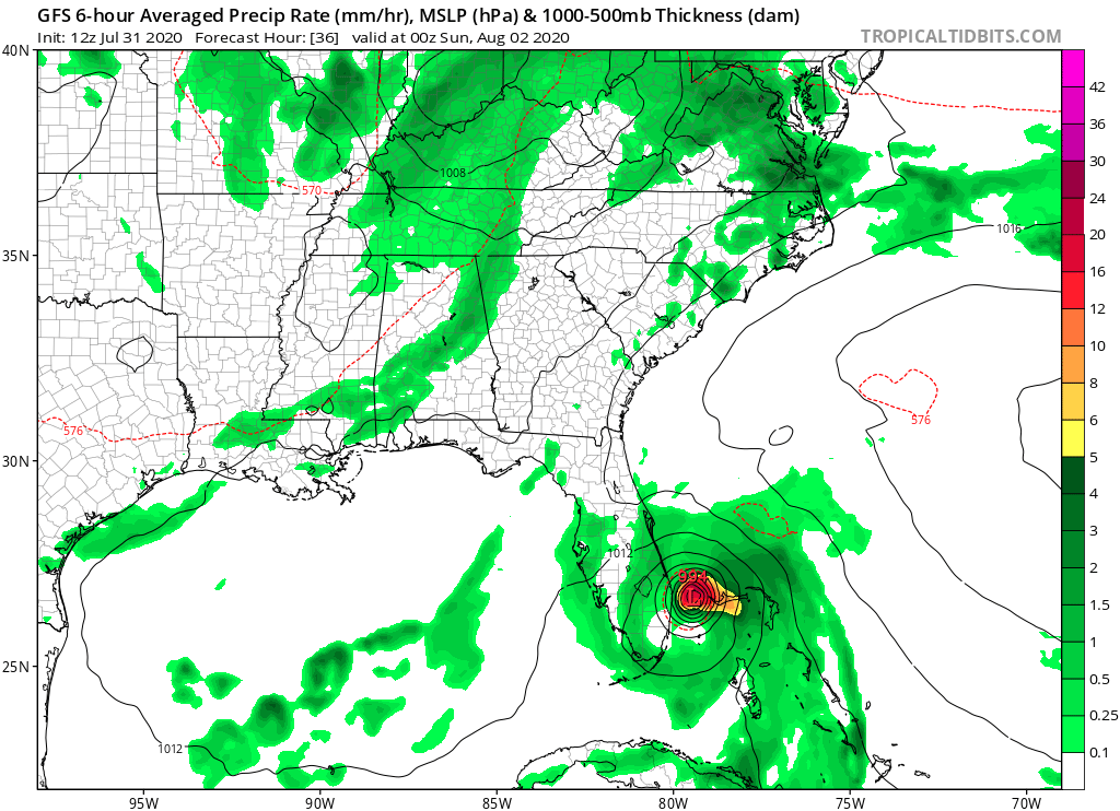
gatorcane wrote:36 hours, slight SW shift from 06Z:
[img]https://i.postimg.cc/c1Xhv722/gfs-mslp-pcpn-seus-6.pn]
This looks a hair west of the 11am NHC track. Could get really bad in Palm Beach county, Gator
Sent from my iPhone using Tapatalk
0 likes

-
cp79
Re: ATL: ISAIAS - Models
For anyone living in Tampa Bay, Irma and Charley are evidence of how models can change just six hours out from landfall. Both models showed those canes were supposed to hit that area the morning of landfall and both took hard unexpected right turns. Just evidence that all should still keep their guard up.
1 likes
-
Weatherboy1

- Category 5
- Posts: 1190
- Age: 50
- Joined: Mon Jul 05, 2004 1:50 pm
- Location: Jupiter/Sarasota, FL
Re: ATL: ISAIAS - Models
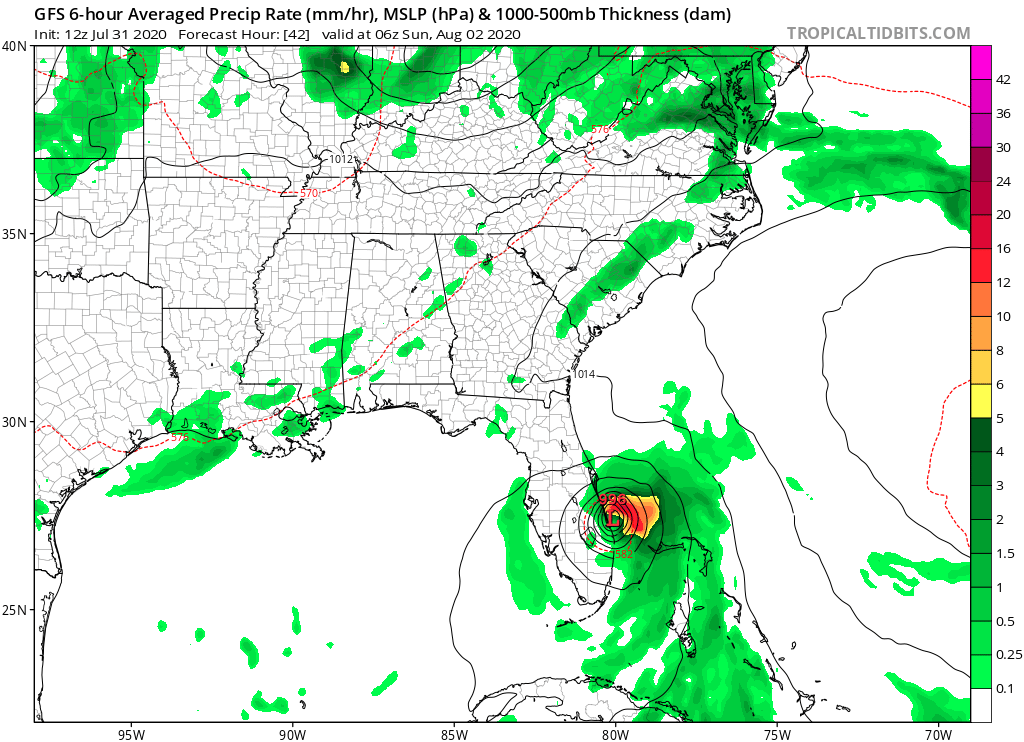
Well well well. GFS showing landfall around Vero or so? Looks like only 20 miles offshore now here in northern PBC Vs 80ish last night. Trend not our friend if others follow GFS
Last edited by Weatherboy1 on Fri Jul 31, 2020 10:44 am, edited 1 time in total.
1 likes
-
Evil Jeremy

- S2K Supporter
- Posts: 5463
- Age: 32
- Joined: Mon Apr 10, 2006 2:10 pm
- Location: Los Angeles, CA
Re: ATL: ISAIAS - Models
If the rest of the model suite has a similar SW shift as the GFS is showing, I think that would warrant a southward extension of the Florida Hurricane Watch at 5pm.... Lets see what the rest of the suite shows.
0 likes
Frances 04 / Jeanne 04 / Katrina 05 / Wilma 05 / Fay 08 / Debby 12 / Andrea 13 / Colin 16 / Hermine 16 / Matthew 16 / Irma 17
-
tolakram
- Admin

- Posts: 20170
- Age: 62
- Joined: Sun Aug 27, 2006 8:23 pm
- Location: Florence, KY (name is Mark)
Re: ATL: ISAIAS - Models
landfall this run

0 likes
M a r k
- - - - -
Join us in chat: Storm2K Chatroom Invite. Android and IOS apps also available.
The posts in this forum are NOT official forecasts and should not be used as such. Posts are NOT endorsed by any professional institution or STORM2K.org. For official information and forecasts, please refer to NHC and NWS products.
-
tolakram
- Admin
- Posts: 20170
- Age: 62
- Joined: Sun Aug 27, 2006 8:23 pm
- Location: Florence, KY (name is Mark)
Re: ATL: ISAIAS - Models
12Z

1 likes
M a r k
- - - - -
Join us in chat: Storm2K Chatroom Invite. Android and IOS apps also available.
The posts in this forum are NOT official forecasts and should not be used as such. Posts are NOT endorsed by any professional institution or STORM2K.org. For official information and forecasts, please refer to NHC and NWS products.
- - - - -
Join us in chat: Storm2K Chatroom Invite. Android and IOS apps also available.
The posts in this forum are NOT official forecasts and should not be used as such. Posts are NOT endorsed by any professional institution or STORM2K.org. For official information and forecasts, please refer to NHC and NWS products.
-
SouthFLTropics

- Category 5
- Posts: 4258
- Age: 50
- Joined: Thu Aug 14, 2003 8:04 am
- Location: Port St. Lucie, Florida
Re: ATL: ISAIAS - Models
Well, the time has come to put my preps into action. Can't wait any longer. Isaias is coming and is gonna be a real close call here on the Treasure Coast. Shutters going up this afternoon. Been through this time and time again. As much of a problem this is, I'll take this over what could have been with Dorian last year.
3 likes
Fourth Generation Florida Native
Personal Storm History: David 79, Andrew 92, Erin 95, Floyd 99, Irene 99, Frances 04, Jeanne 04, Wilma 05, Matthew 16, Irma 17, Ian 22, Nicole 22, Milton 24
Personal Storm History: David 79, Andrew 92, Erin 95, Floyd 99, Irene 99, Frances 04, Jeanne 04, Wilma 05, Matthew 16, Irma 17, Ian 22, Nicole 22, Milton 24
-
tolakram
- Admin
- Posts: 20170
- Age: 62
- Joined: Sun Aug 27, 2006 8:23 pm
- Location: Florence, KY (name is Mark)
Re: ATL: ISAIAS - Models
Much weaker after Florida scrape.

1 likes
M a r k
- - - - -
Join us in chat: Storm2K Chatroom Invite. Android and IOS apps also available.
The posts in this forum are NOT official forecasts and should not be used as such. Posts are NOT endorsed by any professional institution or STORM2K.org. For official information and forecasts, please refer to NHC and NWS products.
- - - - -
Join us in chat: Storm2K Chatroom Invite. Android and IOS apps also available.
The posts in this forum are NOT official forecasts and should not be used as such. Posts are NOT endorsed by any professional institution or STORM2K.org. For official information and forecasts, please refer to NHC and NWS products.
-
tolakram
- Admin
- Posts: 20170
- Age: 62
- Joined: Sun Aug 27, 2006 8:23 pm
- Location: Florence, KY (name is Mark)
Re: ATL: ISAIAS - Models

0 likes
M a r k
- - - - -
Join us in chat: Storm2K Chatroom Invite. Android and IOS apps also available.
The posts in this forum are NOT official forecasts and should not be used as such. Posts are NOT endorsed by any professional institution or STORM2K.org. For official information and forecasts, please refer to NHC and NWS products.
- - - - -
Join us in chat: Storm2K Chatroom Invite. Android and IOS apps also available.
The posts in this forum are NOT official forecasts and should not be used as such. Posts are NOT endorsed by any professional institution or STORM2K.org. For official information and forecasts, please refer to NHC and NWS products.


Re: ATL: ISAIAS - Models
GFS must take it a little way inland to weaken it or it stays inland along the coast for many miles.
0 likes
-
tolakram
- Admin
- Posts: 20170
- Age: 62
- Joined: Sun Aug 27, 2006 8:23 pm
- Location: Florence, KY (name is Mark)
Re: ATL: ISAIAS - Models
GFS 12Z run

0 likes
M a r k
- - - - -
Join us in chat: Storm2K Chatroom Invite. Android and IOS apps also available.
The posts in this forum are NOT official forecasts and should not be used as such. Posts are NOT endorsed by any professional institution or STORM2K.org. For official information and forecasts, please refer to NHC and NWS products.
- - - - -
Join us in chat: Storm2K Chatroom Invite. Android and IOS apps also available.
The posts in this forum are NOT official forecasts and should not be used as such. Posts are NOT endorsed by any professional institution or STORM2K.org. For official information and forecasts, please refer to NHC and NWS products.
Who is online
Users browsing this forum: No registered users and 48 guests