2020 Indicators: SST's / SAL / MSLP / Steering / Shear / Instability / Sat Images
Moderator: S2k Moderators
Forum rules

The posts in this forum are NOT official forecasts and should not be used as such. They are just the opinion of the poster and may or may not be backed by sound meteorological data. They are NOT endorsed by any professional institution or STORM2K. For official information, please refer to products from the National Hurricane Center and National Weather Service.
-
TheHurricaneGod
- Tropical Storm

- Posts: 165
- Age: 23
- Joined: Thu Apr 16, 2020 6:19 pm
- Location: Fort Lauderdale
-
cheezyWXguy

- Category 5

- Posts: 6282
- Joined: Mon Feb 13, 2006 12:29 am
- Location: Dallas, TX
Re: 2020 Indicators: SST's / SAL / MSLP / Steering / Shear / Instability / Sat Images
St0rmTh0r wrote:EquusStorm wrote:We're already on a record four year streak of category five hurricane occurrences, and remarkably also a record streak of three straight years with category five landfalls; if any season has the potential to continue at least one of those dubious streaks, this one has the looks of it
This year feels like a culmination of a very active phase
that started in 2016. Which is why all signs point to hyperactivity.
Is 4 years in a row with a cat 5 really a record though? I never knew that, and it feels like it must have occurred before, but then again I can’t recall a 4 year cat5 streak in the past off the top of my head. Man, hurricane season is weird...
3 likes
-
AnnularCane

- S2K Supporter

- Posts: 2962
- Joined: Thu Jun 08, 2006 9:18 am
- Location: Wytheville, VA
Re: 2020 Indicators: SST's / SAL / MSLP / Steering / Shear / Instability / Sat Images
What is that?
0 likes

Re: 2020 Indicators: SST's / SAL / MSLP / Steering / Shear / Instability / Sat Images
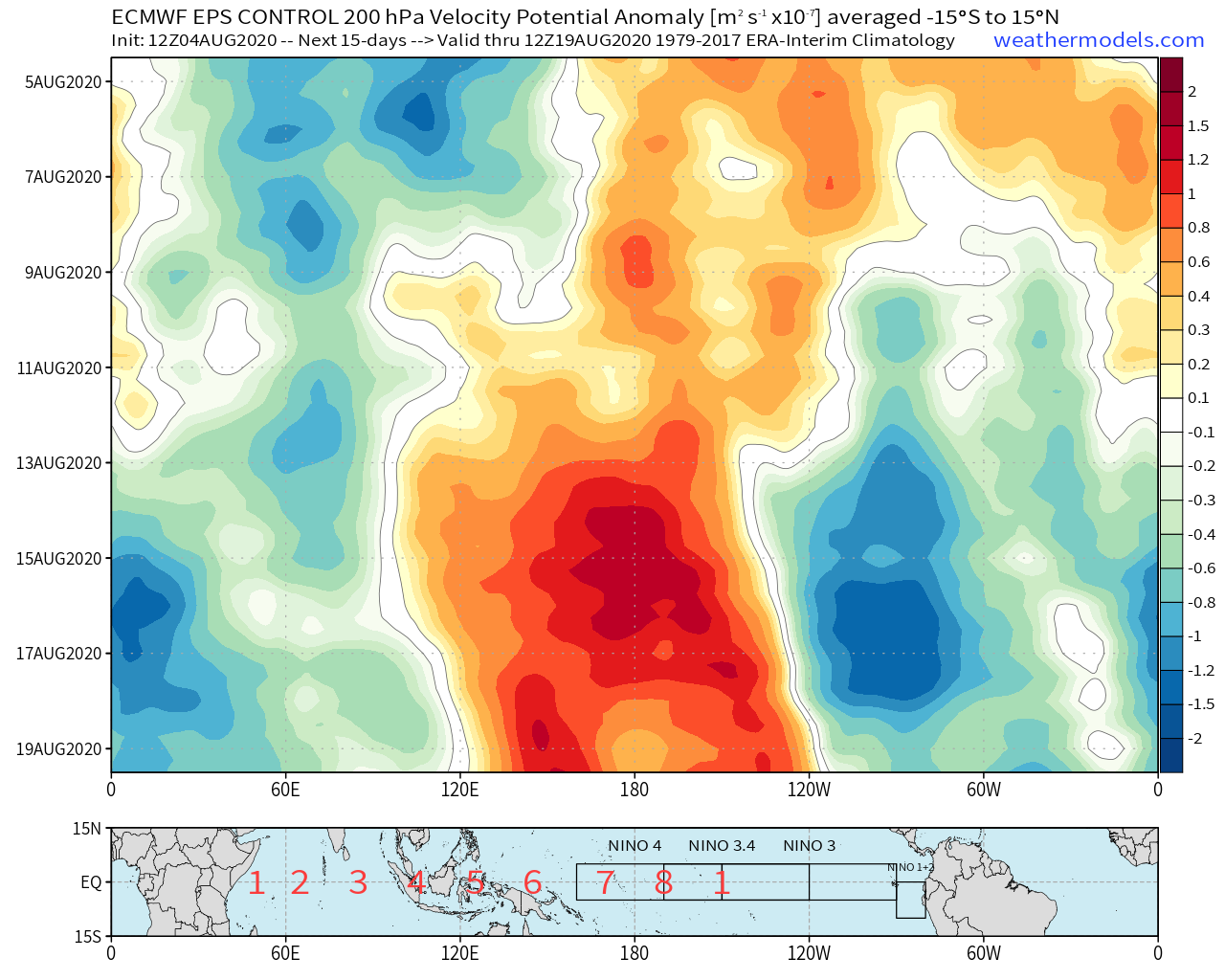
Suppression over much of the Pacific and enhanced convection over much of the Atlantic, coupled with the standing wave over Africa and the suppressive CCKW leaving...I sense the lid coming off in mid-August.
3 likes
Irene '11 Sandy '12 Hermine '16 5/15/2018 Derecho Fay '20 Isaias '20 Elsa '21 Henri '21 Ida '21
I am only a meteorology enthusiast who knows a decent amount about tropical cyclones. Look to the professional mets, the NHC, or your local weather office for the best information.
I am only a meteorology enthusiast who knows a decent amount about tropical cyclones. Look to the professional mets, the NHC, or your local weather office for the best information.
-
supercane4867
- Category 5
- Posts: 4966
- Joined: Wed Nov 14, 2012 10:43 am
Re: 2020 Indicators: SST's / SAL / MSLP / Steering / Shear / Instability / Sat Images
cheezyWXguy wrote:St0rmTh0r wrote:EquusStorm wrote:We're already on a record four year streak of category five hurricane occurrences, and remarkably also a record streak of three straight years with category five landfalls; if any season has the potential to continue at least one of those dubious streaks, this one has the looks of it
This year feels like a culmination of a very active phase
that started in 2016. Which is why all signs point to hyperactivity.
Is 4 years in a row with a cat 5 really a record though? I never knew that, and it feels like it must have occurred before, but then again I can’t recall a 4 year cat5 streak in the past off the top of my head. Man, hurricane season is weird...
There are only 36 official CAT5s since the record begin. However due to changes of observation and assessment techniques over the years, such record is really not that meaningful.
Storms like Matthew would not be assessed as CAT5 over a decade ago when SFMR was not widely used. Probably won't be a CAT5 this year either since they later found SFMR numbers can be easily inflated in these intense systems(Irma was downgraded from 160kt to 155kt because of that).
0 likes

Re: 2020 Indicators: SST's / SAL / MSLP / Steering / Shear / Instability / Sat Images
supercane4867 wrote:cheezyWXguy wrote:St0rmTh0r wrote:This year feels like a culmination of a very active phase
that started in 2016. Which is why all signs point to hyperactivity.
Is 4 years in a row with a cat 5 really a record though? I never knew that, and it feels like it must have occurred before, but then again I can’t recall a 4 year cat5 streak in the past off the top of my head. Man, hurricane season is weird...
There are only 36 official CAT5s since the record begin. However due to changes of observation and assessment techniques over the years, such record is really not that meaningful.
Storms like Matthew would not be assessed as CAT5 over a decade ago when SFMR was not widely used. Probably won't be a CAT5 this year either since they later found SFMR numbers can be easily inflated in these intense systems(Irma was downgraded from 160kt to 155kt because of that).
Irma, Maria, Dorian, and Michael would all have likely been classed as category 5 hurricanes per the standard applied to Emily + without SFMR. Matthew and Lorenzo, almost certainly not IMO.
3 likes
Kendall -> SLO -> PBC
Memorable Storms: Katrina (for its Florida landfall...) Wilma Matthew Irma
Memorable Storms: Katrina (for its Florida landfall...) Wilma Matthew Irma
-
USTropics
- Professional-Met

- Posts: 2738
- Joined: Sun Aug 12, 2007 3:45 am
- Location: Florida State University
Re: 2020 Indicators: SST's / SAL / MSLP / Steering / Shear / Instability / Sat Images
supercane4867 wrote:cheezyWXguy wrote:St0rmTh0r wrote:This year feels like a culmination of a very active phase
that started in 2016. Which is why all signs point to hyperactivity.
Is 4 years in a row with a cat 5 really a record though? I never knew that, and it feels like it must have occurred before, but then again I can’t recall a 4 year cat5 streak in the past off the top of my head. Man, hurricane season is weird...
There are only 36 official CAT5s since the record begin. However due to changes of observation and assessment techniques over the years, such record is really not that meaningful.
Storms like Matthew would not be assessed as CAT5 over a decade ago when SFMR was not widely used. Probably won't be a CAT5 this year either since they later found SFMR numbers can be easily inflated in these intense systems(Irma was downgraded from 160kt to 155kt because of that).
There has only been one streak of 3 straight years of recorded Cat5 hurricanes (2003, 2004, 2005 - not including the current 4 straight years we're currently on). There have been multiple 3/4 years, with some close cases. 2006 was void of a Cat5 hurricane, otherwise 2003-2007 would have recorded Cat5 hurricanes.
1932 ("Camaguey"), 1933 ("Cuba-Brownsville"), and 1935 ("Labor Day") had recorded Cat5s. 1934 did not (highest record was cat3).
1977 (Anita),1979 (David), 1980 (Allen) had recorded Cat5s. 1978 did not (Ella and Greta were both recorded as Cat4 hurricanes).
2003 (Isabel), 2004 (Ivan), 2005 (Emily/Katrina/Rita/WIlma), 2007 (Dean/Felix) had recorded Cat5s. 2006 did not (highest recorded was cat3).
2016 (Matthew), 2017 (Irma/Maria), 2018 (Michael), 2019 (Dorian/Lorenzo) is the only recorded streak of 4 consecutive years of Cat5 hurricanes.
8 likes
-
ScottNAtlanta

- Category 5
- Posts: 2535
- Joined: Sat May 25, 2013 3:11 pm
- Location: Atlanta, GA
Re: 2020 Indicators: SST's / SAL / MSLP / Steering / Shear / Instability / Sat Images
The MJO has been in phases 1,2 or 3 all summer long. Those are also the positive phases for the Atlantic Basin. It's currently in 4 which isnt very favorable, but it is taking a shortcut through the center to go back to phase 1...The JMA has it backtrack to 3...everything seems to indicate 2 weeks of calm before they start popping.
3 likes
The posts in this forum are NOT official forecast and should not be used as such. They are just the opinion of the poster and may or may not be backed by sound meteorological data. They are NOT endorsed by any professional institution or storm2k.org. For official information, please refer to the NHC and NWS products.

Re: 2020 Indicators: SST's / SAL / MSLP / Steering / Shear / Instability / Sat Images
You have to be impressed with how much of the Eastern US has been impacted by the 2020 Atlantic Season this early. Most states from Texas northeastward (I counted 25 plus Washington D.C.) have experienced at least tropical storm conditions. The only ones I'm not sure are Minnesota (Cristobal ?), West Virginia (Isaias?), Michigan, Tennessee, Ohio, Kentucky and Indiana.
It's hard to derive any hints from the landfalls or the movements of some of these early season systems except to infer that many or all of us near the coast and in the interior southeast and east might be at risk in similar patterns. We haven't ever been this active, so we don't really know if the wide open/across the board early season landfalls will translate into the late summer and fall. Maybe we were just unlucky in the early season and patterns will evolve and balance out later in the season. Maybe tracks will coalesce around certain areas that will take repeated hits. Maybe many or even every state that has already experienced TS conditions will experience them again. There are a lot of questions yet to be answered about potential landfall areas as the season gets stronger.
I feel like it's a reasonable assumption to guess that there will be 8-10 hurricanes to come between mid-late August and Halloween (12 1/2 weeks). I think it's also safe to assume that the US will be hit again this year, but we will have to wait for the details.
13 likes

Re: 2020 Indicators: SST's / SAL / MSLP / Steering / Shear / Instability / Sat Images
In another words we have about a week to relax and catch up on some sleep before all hell gets loose over in the Atlantic.
10 likes
-
cycloneye

- Admin

- Posts: 149441
- Age: 69
- Joined: Thu Oct 10, 2002 10:54 am
- Location: San Juan, Puerto Rico
Re: 2020 Indicators: SST's / SAL / MSLP / Steering / Shear / Instability / Sat Images
5 likes
Visit the Caribbean-Central America Weather Thread where you can find at first post web cams,radars
and observations from Caribbean basin members Click Here
and observations from Caribbean basin members Click Here
-
HurricaneEdouard

- Tropical Storm
- Posts: 140
- Joined: Sun May 03, 2015 11:09 am
Re: 2020 Indicators: SST's / SAL / MSLP / Steering / Shear / Instability / Sat Images
USTropics wrote:supercane4867 wrote:cheezyWXguy wrote:Is 4 years in a row with a cat 5 really a record though? I never knew that, and it feels like it must have occurred before, but then again I can’t recall a 4 year cat5 streak in the past off the top of my head. Man, hurricane season is weird...
There are only 36 official CAT5s since the record begin. However due to changes of observation and assessment techniques over the years, such record is really not that meaningful.
Storms like Matthew would not be assessed as CAT5 over a decade ago when SFMR was not widely used. Probably won't be a CAT5 this year either since they later found SFMR numbers can be easily inflated in these intense systems(Irma was downgraded from 160kt to 155kt because of that).
There has only been one streak of 3 straight years of recorded Cat5 hurricanes (2003, 2004, 2005 - not including the current 4 straight years we're currently on). There have been multiple 3/4 years, with some close cases. 2006 was void of a Cat5 hurricane, otherwise 2003-2007 would have recorded Cat5 hurricanes.
1932 ("Camaguey"), 1933 ("Cuba-Brownsville"), and 1935 ("Labor Day") had recorded Cat5s. 1934 did not (highest record was cat3).
1977 (Anita),1979 (David), 1980 (Allen) had recorded Cat5s. 1978 did not (Ella and Greta were both recorded as Cat4 hurricanes).
2003 (Isabel), 2004 (Ivan), 2005 (Emily/Katrina/Rita/WIlma), 2007 (Dean/Felix) had recorded Cat5s. 2006 did not (highest recorded was cat3).
2016 (Matthew), 2017 (Irma/Maria), 2018 (Michael), 2019 (Dorian/Lorenzo) is the only recorded streak of 4 consecutive years of Cat5 hurricanes.
1932 and 1933 were back-to-back years with multiple Category 5s each season, as well; 1932 had San Ciprián and Camaguey, 1933 had Cuba-Brownsville and Great Tampico. This is something we haven't had in the recent AMO+ phase (yet, anyway; I wouldn't be surprised if 2020 gave us multiple Category 5s).
1 likes
You know you're a hurricane nut, when your main source of adrenaline is reading old hurricane advisories...
-
toad strangler

- S2K Supporter
- Posts: 4546
- Joined: Sun Jul 28, 2013 3:09 pm
- Location: Earth
- Contact:
-
toad strangler
- S2K Supporter
- Posts: 4546
- Joined: Sun Jul 28, 2013 3:09 pm
- Location: Earth
- Contact:
-
SFLcane

- S2K Supporter
- Posts: 10281
- Age: 48
- Joined: Sat Jun 05, 2010 1:44 pm
- Location: Lake Worth Florida
Re: 2020 Indicators: SST's / SAL / MSLP / Steering / Shear / Instability / Sat Images
toad strangler wrote:http://twitter.com/andyhazelton/status/1290991057115787265?s=21
Very dangerous for the east coast if it holds.
0 likes
-
cycloneye
- Admin
- Posts: 149441
- Age: 69
- Joined: Thu Oct 10, 2002 10:54 am
- Location: San Juan, Puerto Rico
Re: 2020 Indicators: SST's / SAL / MSLP / Steering / Shear / Instability / Sat Images
The only thing I am going to say is this video from Mark Sudduth is omminous.
https://www.facebook.com/HurricaneTrack ... 7475455036
https://www.facebook.com/HurricaneTrack ... 7475455036
5 likes
Visit the Caribbean-Central America Weather Thread where you can find at first post web cams,radars
and observations from Caribbean basin members Click Here
and observations from Caribbean basin members Click Here
-
AxaltaRacing24
- Category 5
- Posts: 1774
- Age: 25
- Joined: Wed Jul 27, 2016 11:14 am
- Location: Jupiter, FL
Re: 2020 Indicators: SST's / SAL / MSLP / Steering / Shear / Instability / Sat Images
SFLcane wrote:toad strangler wrote:http://twitter.com/andyhazelton/status/1290991057115787265?s=21
Very dangerous for the east coast if it holds.
this season's outlook is more ominous that 2017's.
hopefully it's only the outlook that stays that way, but i'm not too sure.
0 likes
-
gatorcane

- S2K Supporter
- Posts: 23708
- Age: 48
- Joined: Sun Mar 13, 2005 3:54 pm
- Location: Boca Raton, FL
Re: 2020 Indicators: SST's / SAL / MSLP / Steering / Shear / Instability / Sat Images
cycloneye wrote:The only thing I am going to say is this video from Mark Sudduth is omminous.
https://www.facebook.com/HurricaneTrack ... 7475455036
Watched it and ominous indeed
0 likes
-
Hurricaneman

- Category 5
- Posts: 7404
- Age: 45
- Joined: Tue Aug 31, 2004 3:24 pm
- Location: central florida
Re: 2020 Indicators: SST's / SAL / MSLP / Steering / Shear / Instability / Sat Images
gatorcane wrote:cycloneye wrote:The only thing I am going to say is this video from Mark Sudduth is omminous.
https://www.facebook.com/HurricaneTrack ... 7475455036
Watched it and ominous indeed
Some of the maps are some of the most dangerous since 2017 and 2005, I feel like this year could be a hybrid of the 2
0 likes
-
toad strangler
- S2K Supporter
- Posts: 4546
- Joined: Sun Jul 28, 2013 3:09 pm
- Location: Earth
- Contact:
Re: 2020 Indicators: SST's / SAL / MSLP / Steering / Shear / Instability / Sat Images
cycloneye wrote:The only thing I am going to say is this video from Mark Sudduth is omminous.
https://www.facebook.com/HurricaneTrack ... 7475455036
Egads, who knows what will actually happen but I GUARANTEE you we won't see pre season signals this provocative again for quite some time. It's been a steady uninterrupted drumbeat since the WINTER.
4 likes
My Weather Station
https://www.wunderground.com/dashboard/pws/KFLPORTS603
https://www.wunderground.com/dashboard/pws/KFLPORTS603
Who is online
Users browsing this forum: No registered users and 601 guests