2020 Indicators: SST's / SAL / MSLP / Steering / Shear / Instability / Sat Images

This is the general tropical discussion area. Anyone can take their shot at predicting a storms path.

Moderator: S2k Moderators

Forum rules

The posts in this forum are NOT official forecasts and should not be used as such. They are just the opinion of the poster and may or may not be backed by sound meteorological data. They are NOT endorsed by any professional institution or STORM2K. For official information, please refer to products from the National Hurricane Center and National Weather Service.

Help Support Storm2K
Message
Author
User avatar
Hammy
Category 5
Category 5
Posts: 5849
Age: 41
Joined: Fri May 25, 2012 5:25 pm
Contact:

Re: 2020 Indicators: SST's / SAL / MSLP / Steering / Shear / Instability / Sat Images

#2261 Postby Hammy » Fri Aug 07, 2020 7:11 pm

SFLcane wrote:Here is the NMME for September in 2017. Shows dry SW Atlantic also so can’t really use this as general tracks. Guess Irma didn’t go through there lol. :roll:

https://iili.io/dEB5pj.png


Are those more indicative of where (and how many) storms will form rather than where they'll go after?
0 likes   
The above post is not official and should not be used as such. It is the opinion of the poster and may or may not be backed by sound meteorological data. It is not endorsed by any professional institution or storm2k.org. For official information, please refer to the NHC and NWS products.

User avatar
cycloneye
Admin
Admin
Posts: 145299
Age: 68
Joined: Thu Oct 10, 2002 10:54 am
Location: San Juan, Puerto Rico

Re: 2020 Indicators: SST's / SAL / MSLP / Steering / Shear / Instability / Sat Images

#2262 Postby cycloneye » Fri Aug 07, 2020 7:37 pm

There is even more to again do this? :eek:

 https://twitter.com/webberweather/status/1291895856749252610


0 likes   
Visit the Caribbean-Central America Weather Thread where you can find at first post web cams,radars
and observations from Caribbean basin members Click Here

TheStormExpert

Re: 2020 Indicators: SST's / SAL / MSLP / Steering / Shear / Instability / Sat Images

#2263 Postby TheStormExpert » Fri Aug 07, 2020 7:54 pm

Hammy wrote:
SFLcane wrote:Here is the NMME for September in 2017. Shows dry SW Atlantic also so can’t really use this as general tracks. Guess Irma didn’t go through there lol. :roll:

https://iili.io/dEB5pj.png


Are those more indicative of where (and how many) storms will form rather than where they'll go after?

No it does not show how many storms will form but it can be an indicator of where a storm(s) may track. In this case tracks into the Caribbean and into CA or Mexico or north into the GoM seem likely thanks to an abnormally very strong Bermuda High. Not saying Florida is off the hook but just going off that I would bet on more threats from the SW as opposed to the SE.
1 likes   

User avatar
SFLcane
S2K Supporter
S2K Supporter
Posts: 10163
Age: 47
Joined: Sat Jun 05, 2010 1:44 pm
Location: Lake Worth Florida

Re: 2020 Indicators: SST's / SAL / MSLP / Steering / Shear / Instability / Sat Images

#2264 Postby SFLcane » Fri Aug 07, 2020 7:55 pm

cycloneye wrote:There is even more to again do this? :eek:

https://twitter.com/webberweather/status/1291895856749252610


Hi Luis, for now it Doesn't matter if the Atlantic is dry. We'll see when that changes.
2 likes   

User avatar
toad strangler
S2K Supporter
S2K Supporter
Posts: 4543
Joined: Sun Jul 28, 2013 3:09 pm
Location: Earth
Contact:

Re: 2020 Indicators: SST's / SAL / MSLP / Steering / Shear / Instability / Sat Images

#2265 Postby toad strangler » Fri Aug 07, 2020 7:57 pm

cycloneye wrote:There is even more to again do this? :eek:

https://twitter.com/webberweather/status/1291895856749252610


That is amazing! Not sure what it actually means for Cabo Verde season and the strength or frequency of AEW's going forward though.
0 likes   

TheStormExpert

Re: 2020 Indicators: SST's / SAL / MSLP / Steering / Shear / Instability / Sat Images

#2266 Postby TheStormExpert » Fri Aug 07, 2020 8:00 pm

cycloneye wrote:There is even more to again do this? :eek:

https://twitter.com/webberweather/status/1291895856749252610

It seems that every time a tropical wave moves off the west coast of Africa more Saharan Air gets pulled off as well, is this normally the case?
0 likes   

User avatar
toad strangler
S2K Supporter
S2K Supporter
Posts: 4543
Joined: Sun Jul 28, 2013 3:09 pm
Location: Earth
Contact:

Re: 2020 Indicators: SST's / SAL / MSLP / Steering / Shear / Instability / Sat Images

#2267 Postby toad strangler » Fri Aug 07, 2020 8:02 pm

TheStormExpert wrote:
cycloneye wrote:There is even more to again do this? :eek:

https://twitter.com/webberweather/status/1291895856749252610

It seems that every time a tropical wave moves off the west coast of Africa more Saharan Air gets pulled off as well, is this normally the case?


I don't know how many times it can be stated for this to sink in. YES. All the way through mid August it's expected. If this was still happening in VERY LATE August and snuffing out AEW's then there may be an anomalous situation happening.
5 likes   

User avatar
SFLcane
S2K Supporter
S2K Supporter
Posts: 10163
Age: 47
Joined: Sat Jun 05, 2010 1:44 pm
Location: Lake Worth Florida

Re: 2020 Indicators: SST's / SAL / MSLP / Steering / Shear / Instability / Sat Images

#2268 Postby SFLcane » Fri Aug 07, 2020 8:04 pm

toad strangler wrote:
TheStormExpert wrote:
cycloneye wrote:There is even more to again do this? :eek:

https://twitter.com/webberweather/status/1291895856749252610

It seems that every time a tropical wave moves off the west coast of Africa more Saharan Air gets pulled off as well, is this normally the case?


I don't know how many times it can be stated for this to sink in. YES. All the way through mid August it's expected. If this was still happening in VERY LATE August and snuffing out AEW's then there may be an anomalous situation happening.


This should be pinned on the top of this thread. :roll:
2 likes   

St0rmTh0r
Category 1
Category 1
Posts: 369
Joined: Tue Jul 14, 2020 8:04 pm

Re: 2020 Indicators: SST's / SAL / MSLP / Steering / Shear / Instability / Sat Images

#2269 Postby St0rmTh0r » Fri Aug 07, 2020 8:08 pm

toad strangler wrote:
cycloneye wrote:There is even more to again do this? :eek:

https://twitter.com/webberweather/status/1291895856749252610


That is amazing! Not sure what it actually means for Cabo Verde season and the strength or frequency of AEW's going forward though.

It means more thunderstorms which means more tropical waves which means lots hurricanes come peak season
0 likes   

St0rmTh0r
Category 1
Category 1
Posts: 369
Joined: Tue Jul 14, 2020 8:04 pm

Re: 2020 Indicators: SST's / SAL / MSLP / Steering / Shear / Instability / Sat Images

#2270 Postby St0rmTh0r » Fri Aug 07, 2020 8:09 pm

SFLcane wrote:
toad strangler wrote:
TheStormExpert wrote:It seems that every time a tropical wave moves off the west coast of Africa more Saharan Air gets pulled off as well, is this normally the case?


I don't know how many times it can be stated for this to sink in. YES. All the way through mid August it's expected. If this was still happening in VERY LATE August and snuffing out AEW's then there may be an anomalous situation happening.


This should be pinned on the top of this thread. :roll:

1+1=2
0 likes   

TheStormExpert

Re: 2020 Indicators: SST's / SAL / MSLP / Steering / Shear / Instability / Sat Images

#2271 Postby TheStormExpert » Fri Aug 07, 2020 8:13 pm

toad strangler wrote:
TheStormExpert wrote:
cycloneye wrote:There is even more to again do this? :eek:

https://twitter.com/webberweather/status/1291895856749252610

It seems that every time a tropical wave moves off the west coast of Africa more Saharan Air gets pulled off as well, is this normally the case?


I don't know how many times it can be stated for this to sink in. YES. All the way through mid August it's expected. If this was still happening in VERY LATE August and snuffing out AEW's then there may be an anomalous situation happening.

I was just asking cause I never really noticed that being the case.
2 likes   

User avatar
gatorcane
S2K Supporter
S2K Supporter
Posts: 23691
Age: 47
Joined: Sun Mar 13, 2005 3:54 pm
Location: Boca Raton, FL

Re: 2020 Indicators: SST's / SAL / MSLP / Steering / Shear / Instability / Sat Images

#2272 Postby gatorcane » Fri Aug 07, 2020 8:15 pm

I am wondering if the warmer than normal waters north of the equator and south of Mexico is part of the reason we are seeing an uptick in EPAC activity. Will need to watch this area as it it could cause a bit more EPAC activity / convection / rising air which in turn could induce some more shear across the Caribbean and Gulf at times despite the lack of an El Niño. 2010 didn’t have such a warm pool. 2005 did but not quite as extensive:

Image
0 likes   

User avatar
cycloneye
Admin
Admin
Posts: 145299
Age: 68
Joined: Thu Oct 10, 2002 10:54 am
Location: San Juan, Puerto Rico

Re: 2020 Indicators: SST's / SAL / MSLP / Steering / Shear / Instability / Sat Images

#2273 Postby cycloneye » Fri Aug 07, 2020 8:24 pm

All on one tweet.You will not have another season more favorable than 2020 for many years.

 https://twitter.com/webberweather/status/1291906670055043072


4 likes   
Visit the Caribbean-Central America Weather Thread where you can find at first post web cams,radars
and observations from Caribbean basin members Click Here

TheStormExpert

Re: 2020 Indicators: SST's / SAL / MSLP / Steering / Shear / Instability / Sat Images

#2274 Postby TheStormExpert » Fri Aug 07, 2020 8:34 pm

gatorcane wrote:I am wondering if the warmer than normal waters north of the equator and south of Mexico is part of the reason we are seeing an uptick in EPAC activity. Will need to watch this area as it it could cause a bit more EPAC activity / convection / rising air which in turn could induce some more shear across the Caribbean and Gulf at times despite the lack of an El Niño. 2010 didn’t have such a warm pool. 2005 did but not quite as extensive:

https://i.postimg.cc/g27DBBGt/ssta-daily-current.png

This season is likely to go off in a few weeks time. If I were you I’d be preparing just in case. Yes, we may get lucky but with such high numbers being forecasted I’d rather be safe than sorry.
2 likes   

User avatar
StruThiO
Category 3
Category 3
Posts: 821
Age: 25
Joined: Fri Sep 15, 2017 5:51 am
Location: Currently Portland, OR. Raised in Jax, FL.

Re: 2020 Indicators: SST's / SAL / MSLP / Steering / Shear / Instability / Sat Images

#2275 Postby StruThiO » Fri Aug 07, 2020 8:44 pm

All indicators tell me that all hell is going to break loose once the bell is rung on the 20th.
5 likes   


User avatar
SFLcane
S2K Supporter
S2K Supporter
Posts: 10163
Age: 47
Joined: Sat Jun 05, 2010 1:44 pm
Location: Lake Worth Florida

Re: 2020 Indicators: SST's / SAL / MSLP / Steering / Shear / Instability / Sat Images

#2277 Postby SFLcane » Fri Aug 07, 2020 10:14 pm

If mid Aug approaches and the MJO is here and dry air is still around then it's going to be a problem.
0 likes   

AxaltaRacing24
Category 5
Category 5
Posts: 1753
Age: 25
Joined: Wed Jul 27, 2016 11:14 am
Location: Jupiter, FL

Re: 2020 Indicators: SST's / SAL / MSLP / Steering / Shear / Instability / Sat Images

#2278 Postby AxaltaRacing24 » Fri Aug 07, 2020 10:16 pm

SFLcane wrote:If mid Aug approaches and the MJO is here and dry air is still around then it's going to be a problem.

possibly, but people tried cancelling 2017 in late august over the same thing.

then the dry air vanished shortly after august 20th.
5 likes   

User avatar
toad strangler
S2K Supporter
S2K Supporter
Posts: 4543
Joined: Sun Jul 28, 2013 3:09 pm
Location: Earth
Contact:

Re: 2020 Indicators: SST's / SAL / MSLP / Steering / Shear / Instability / Sat Images

#2279 Postby toad strangler » Fri Aug 07, 2020 10:32 pm

AxaltaRacing24 wrote:
SFLcane wrote:If mid Aug approaches and the MJO is here and dry air is still around then it's going to be a problem.

possibly, but people tried cancelling 2017 in late august over the same thing.

then the dry air vanished shortly after august 20th.


Like the flip of a switch.
0 likes   

869MB
S2K Supporter
S2K Supporter
Posts: 162
Joined: Thu Feb 14, 2019 9:49 pm
Location: Katy, TX

Re: 2020 Indicators: SST's / SAL / MSLP / Steering / Shear / Instability / Sat Images

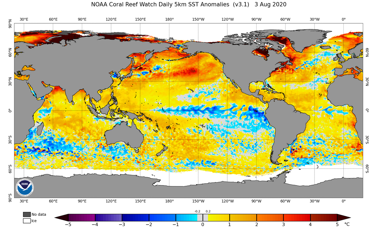
#2280 Postby 869MB » Fri Aug 07, 2020 10:39 pm

Analyzing some of these indicators being presented for the past month feels akin to the countdown of the hours after midnight where the SPC has just issued a High Risk for the Day 1 Convective Outlook where a large multi-state severe weather & tornado outbreak is forecasted with a high chance of numerous, widespread long-tracked strong and violent tornadoes. After the SPC issues that Day 1 outlook you know nothing is never set in stone and unseen weather parameters may occur where their forecast may bust. But as the hours count down to the early afternoon, all of the necessary severe weather ingredients appear to come together in order to fuel the outbreak as originally forecasted.

That’s where I feel we are now with respect to this 2020 hurricane season, in those early morning hours of a possible significant severe weather/tornado outbreak. Yeah there are possible unseen weather parameters that may occur which could limit or prevent an outbreak, but it appears to be increasingly unlikely as each hour passes.
5 likes   


Return to “Talkin' Tropics”

Who is online

Users browsing this forum: Ulf and 29 guests