2020 Indicators: SST's / SAL / MSLP / Steering / Shear / Instability / Sat Images
Moderator: S2k Moderators
Forum rules

The posts in this forum are NOT official forecasts and should not be used as such. They are just the opinion of the poster and may or may not be backed by sound meteorological data. They are NOT endorsed by any professional institution or STORM2K. For official information, please refer to products from the National Hurricane Center and National Weather Service.
-
SFLcane

- S2K Supporter

- Posts: 10281
- Age: 48
- Joined: Sat Jun 05, 2010 1:44 pm
- Location: Lake Worth Florida
Re: 2020 Indicators: SST's / SAL / MSLP / Steering / Shear / Instability / Sat Images
There's not gonna be a long track TC in the next 10 days so that trough doesn't matter.
0 likes
-
TheStormExpert
Re: 2020 Indicators: SST's / SAL / MSLP / Steering / Shear / Instability / Sat Images
2004, or 2010 people make up your minds!! 
Besides none of this matters anyways for now as there looks to be nothing immediate threatening to develop for the next week or two. Of course that could always change but I’m beginning to think we only end up with 2-3 named storms at most this month, MAYBE one of them a hurricane.
After the record breaking start in May, June, and July in terms of named storm pace I think August will likely underperform in a sense in my opinion as the East Pacific continues to steal the show for now. Let’s see how well this ages in 10 days and we’ll go from there!
0 likes
-
TheStormExpert
Re: 2020 Indicators: SST's / SAL / MSLP / Steering / Shear / Instability / Sat Images
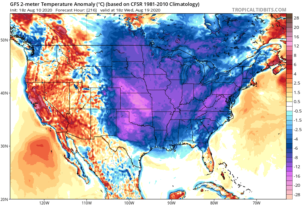
AutoPenalti wrote:gatorcane wrote:I notice the models are trying to dig an anomalously strong trough into the eastern CONUS in 8-10 days. Check out the GFS temp anomalies albeit in the long-range and probably too cold. Indicator fall may start earlier than normal this year ushering in the westerlies or no indicator at all? Looks like 40s and 50s for the Midwest and even colder in southern Canada:
https://i.postimg.cc/nzMvJtFb/gfs-T2ma-us-37.png
That may not be a good thing to be honest.
Why not? Please explain more.
0 likes

Re: 2020 Indicators: SST's / SAL / MSLP / Steering / Shear / Instability / Sat Images
gatorcane wrote:I notice the models are trying to dig an anomalously strong trough into the eastern CONUS in 8-10 days. Check out the GFS temp anomalies albeit in the long-range and probably too cold. Indicator fall may start earlier than normal this year ushering in the westerlies or no indicator at all? Looks like 40s and 50s for the Midwest and even colder in southern Canada:
https://i.postimg.cc/nzMvJtFb/gfs-T2ma-us-37.png
Nothing beats the big trough of mid August 2004 but as you know ridging across the NE US and SE Canada remained strong through early October, the same way long range forecasts and experts are calling for, no signs of a west Atlantic based -NAO coming any time soon.

2 likes
-
AutoPenalti
- Category 5

- Posts: 4091
- Age: 29
- Joined: Mon Aug 17, 2015 4:16 pm
- Location: Ft. Lauderdale, Florida
Re: 2020 Indicators: SST's / SAL / MSLP / Steering / Shear / Instability / Sat Images
TheStormExpert wrote:AutoPenalti wrote:gatorcane wrote:I notice the models are trying to dig an anomalously strong trough into the eastern CONUS in 8-10 days. Check out the GFS temp anomalies albeit in the long-range and probably too cold. Indicator fall may start earlier than normal this year ushering in the westerlies or no indicator at all? Looks like 40s and 50s for the Midwest and even colder in southern Canada:
https://i.postimg.cc/nzMvJtFb/gfs-T2ma-us-37.png
That may not be a good thing to be honest.
Why not? Please explain more.
From what I know, dependent on the strength of the trough, if it becomes negatively tilted, acts as a magnet for developed cyclones.
2 likes
The posts in this forum are NOT official forecasts and should not be used as such. They are just the opinion of the poster and may or may not be backed by sound meteorological data. They are NOT endorsed by any professional institution or STORM2K. For official information, please refer to products from the NHC and NWS.
Model Runs Cheat Sheet:
GFS (5:30 AM/PM, 11:30 AM/PM)
HWRF, GFDL, UKMET, NAVGEM (6:30-8:00 AM/PM, 12:30-2:00 AM/PM)
ECMWF (1:45 AM/PM)
TCVN is a weighted averaged

Re: 2020 Indicators: SST's / SAL / MSLP / Steering / Shear / Instability / Sat Images
TheStormExpert wrote:AutoPenalti wrote:gatorcane wrote:I notice the models are trying to dig an anomalously strong trough into the eastern CONUS in 8-10 days. Check out the GFS temp anomalies albeit in the long-range and probably too cold. Indicator fall may start earlier than normal this year ushering in the westerlies or no indicator at all? Looks like 40s and 50s for the Midwest and even colder in southern Canada:
https://i.postimg.cc/nzMvJtFb/gfs-T2ma-us-37.png
That may not be a good thing to be honest.
Why not? Please explain more.
Amplification
High pressure to the north and NE as troughs lift out
Time of Year
Fronts start coming down = storms start coming up
An old poster I won't name from CFHC busted that idea out in 2004 and 2005. I'm sure I won't have to tell you or anyone else how those years went. Eventually it becomes the fall - probably late October or early November and the westerlies do take over for good.
0 likes
-
EquusStorm
- Category 5
- Posts: 1649
- Age: 35
- Joined: Thu Nov 07, 2013 1:04 pm
- Location: Jasper, AL
- Contact:
Re: 2020 Indicators: SST's / SAL / MSLP / Steering / Shear / Instability / Sat Images
I remember that 2004 trough very fondly, the nicest August weather here I've ever experienced  Not especially good to have any 2004 parallels on modeling though, considering, y'know, that entire season
4 likes
Colors of lost purpose on the canvas of irrelevance
Not a meteorologist, in fact more of an idiot than anything. You should probably check with the NHC or a local NWS office for official information.
Not a meteorologist, in fact more of an idiot than anything. You should probably check with the NHC or a local NWS office for official information.
-
SFLcane
- S2K Supporter
- Posts: 10281
- Age: 48
- Joined: Sat Jun 05, 2010 1:44 pm
- Location: Lake Worth Florida
Re: 2020 Indicators: SST's / SAL / MSLP / Steering / Shear / Instability / Sat Images
NDG wrote:gatorcane wrote:I notice the models are trying to dig an anomalously strong trough into the eastern CONUS in 8-10 days. Check out the GFS temp anomalies albeit in the long-range and probably too cold. Indicator fall may start earlier than normal this year ushering in the westerlies or no indicator at all? Looks like 40s and 50s for the Midwest and even colder in southern Canada:
https://i.postimg.cc/nzMvJtFb/gfs-T2ma-us-37.png
Nothing beats the big trough of mid August 2004 but as you know ridging across the NE US and SE Canada remained strong through early October, the same way long range forecasts and experts are calling for, no signs of a west Atlantic based -NAO coming any time soon.
https://i.imgur.com/r73ioRh.gif
Great post!
1 likes
-
eastcoastFL

- Category 5
- Posts: 3996
- Age: 44
- Joined: Thu Apr 12, 2007 12:29 pm
- Location: Palm City, FL
Re: 2020 Indicators: SST's / SAL / MSLP / Steering / Shear / Instability / Sat Images
This is kinda interesting and scary. The US coast Line primed for potential sub 900mb storms given the ideal upper level conditions

3 likes
Personal Forecast Disclaimer:
The posts in this forum are NOT official forecast and should not be used as such. They are just the opinion of the poster and may or may not be backed by sound meteorological data. They are NOT endorsed by any professional institution or storm2k.org. For official information, please refer to the NHC and NWS products.
The posts in this forum are NOT official forecast and should not be used as such. They are just the opinion of the poster and may or may not be backed by sound meteorological data. They are NOT endorsed by any professional institution or storm2k.org. For official information, please refer to the NHC and NWS products.
-
USTropics
- Professional-Met

- Posts: 2738
- Joined: Sun Aug 12, 2007 3:45 am
- Location: Florida State University
Re: 2020 Indicators: SST's / SAL / MSLP / Steering / Shear / Instability / Sat Images
I'd be watching the western Atlantic starting August 20th. The signals are beginning to appear.
00z GFS-Para ensembles:

00z CMC ensembles:

Past 3 runs of CFS:

VP anomalies for that time period:

00z GFS-Para ensembles:
00z CMC ensembles:
Past 3 runs of CFS:
VP anomalies for that time period:
8 likes
Re: 2020 Indicators: SST's / SAL / MSLP / Steering / Shear / Instability / Sat Images
SFLcane wrote:gatorcane wrote:I notice the models are trying to dig an anomalously strong trough into the eastern CONUS in 8-10 days. Check out the GFS temp anomalies albeit in the long-range and probably too cold. Indicator fall may start earlier than normal this year ushering in the westerlies or no indicator at all? Looks like 40s and 50s for the Midwest and even colder in southern Canada:
https://i.postimg.cc/nzMvJtFb/gfs-T2ma-us-37.png
2010 pattern if it persists. Looks like it cuts off on the Euro
During 2010 the troughs that came down to the eastern US kept progressing eastward towards the NW Atlantic, there was really no ridging east of the mid Atlantic and NE US the reason there were so many OTS tracks.
0 likes
-
SFLcane
- S2K Supporter
- Posts: 10281
- Age: 48
- Joined: Sat Jun 05, 2010 1:44 pm
- Location: Lake Worth Florida
Re: 2020 Indicators: SST's / SAL / MSLP / Steering / Shear / Instability / Sat Images
NDG wrote:SFLcane wrote:gatorcane wrote:I notice the models are trying to dig an anomalously strong trough into the eastern CONUS in 8-10 days. Check out the GFS temp anomalies albeit in the long-range and probably too cold. Indicator fall may start earlier than normal this year ushering in the westerlies or no indicator at all? Looks like 40s and 50s for the Midwest and even colder in southern Canada:
https://i.postimg.cc/nzMvJtFb/gfs-T2ma-us-37.png
2010 pattern if it persists. Looks like it cuts off on the Euro
During 2010 the troughs that came down to the eastern US kept progressing eastward towards the NW Atlantic, there was really no ridging east of the mid Atlantic and NE US the reason there were so many OTS tracks.
A trough next week doesn't mean permanent troughing.Really just have to watch the pattern
0 likes
-
tolakram
- Admin

- Posts: 20185
- Age: 62
- Joined: Sun Aug 27, 2006 8:23 pm
- Location: Florence, KY (name is Mark)
Re: 2020 Indicators: SST's / SAL / MSLP / Steering / Shear / Instability / Sat Images
Every thread I visit has a hyperactive discussion of hyperactivity!
I expect 95L to struggle, which will lead to more of those folks who can only see a couple of days at a time to once again declare this season to be dead. You know it if I'm talking about you! Longer term conditions are very favorable, which means, in my opinion, that when short term conditions improve (less shear mainly) we will see outbreaks of 2, three, and four storms at a time.
I expect 95L to struggle, which will lead to more of those folks who can only see a couple of days at a time to once again declare this season to be dead. You know it if I'm talking about you! Longer term conditions are very favorable, which means, in my opinion, that when short term conditions improve (less shear mainly) we will see outbreaks of 2, three, and four storms at a time.
14 likes
M a r k
- - - - -
Join us in chat: Storm2K Chatroom Invite. Android and IOS apps also available.
The posts in this forum are NOT official forecasts and should not be used as such. Posts are NOT endorsed by any professional institution or STORM2K.org. For official information and forecasts, please refer to NHC and NWS products.
-
cycloneye

- Admin
- Posts: 149458
- Age: 69
- Joined: Thu Oct 10, 2002 10:54 am
- Location: San Juan, Puerto Rico
Re: 2020 Indicators: SST's / SAL / MSLP / Steering / Shear / Instability / Sat Images
Those who like to track storms and hurricanes have patience as they will eventually form. Is only August 11.

6 likes
Visit the Caribbean-Central America Weather Thread where you can find at first post web cams,radars
and observations from Caribbean basin members Click Here
and observations from Caribbean basin members Click Here
-
EquusStorm
- Category 5
- Posts: 1649
- Age: 35
- Joined: Thu Nov 07, 2013 1:04 pm
- Location: Jasper, AL
- Contact:
Re: 2020 Indicators: SST's / SAL / MSLP / Steering / Shear / Instability / Sat Images
Imagine if we had forums in 1984 when the first named storm (after an unnamed STS the week prior) didn't develop until August 28 lol. There would be pandemonium
4 likes
Colors of lost purpose on the canvas of irrelevance
Not a meteorologist, in fact more of an idiot than anything. You should probably check with the NHC or a local NWS office for official information.
Not a meteorologist, in fact more of an idiot than anything. You should probably check with the NHC or a local NWS office for official information.
-
CyclonicFury

- Category 5
- Posts: 2033
- Age: 27
- Joined: Sun Jul 02, 2017 12:32 pm
- Location: NC
- Contact:
Re: 2020 Indicators: SST's / SAL / MSLP / Steering / Shear / Instability / Sat Images
The fact is, when you have much warmer than normal SSTs in the MDR, well below normal shear in the MDR/Caribbean during July, a strong west African Monsoon, you usually get an intense season. I have said this many times but early season weak storms do not mean peak season storms will be weak as well. EqqusStorm had a great comparison a few weeks back...predicting a weak season based on early-season weak storms is like getting snow flurries in November when it usually doesn't snow at all and expecting only snow flurries in January
9 likes
NCSU B.S. in Meteorology Class of 2021. Tropical weather blogger at http://www.cyclonicfury.com. My forecasts and thoughts are NOT official, for official forecasts please consult the National Hurricane Center.
-
AnnularCane

- S2K Supporter
- Posts: 2962
- Joined: Thu Jun 08, 2006 9:18 am
- Location: Wytheville, VA
Re: 2020 Indicators: SST's / SAL / MSLP / Steering / Shear / Instability / Sat Images
cycloneye wrote:Those who like to track storms and hurricanes have patience as they will eventually form. Is only August 11.
There is something about the first half of August that seems to try everyone's patience.
6 likes
-
TheStormExpert
Re: 2020 Indicators: SST's / SAL / MSLP / Steering / Shear / Instability / Sat Images
cycloneye wrote:Those who like to track storms and hurricanes have patience as they will eventually form. Is only August 11.
https://i.imgur.com/kzVXARW.jpg
I understand it’s only August 11th but something just seems off to me and I really don’t know what it is?
0 likes
-
mcheer23

- Professional-Met
- Posts: 441
- Age: 32
- Joined: Sun Jun 24, 2012 8:24 pm
- Location: Sugar Land, Texas
Re: 2020 Indicators: SST's / SAL / MSLP / Steering / Shear / Instability / Sat Images
TheStormExpert wrote:cycloneye wrote:Those who like to track storms and hurricanes have patience as they will eventually form. Is only August 11.
https://i.imgur.com/kzVXARW.jpg
I understand it’s only August 11th but something just seems off to me and I really don’t know what it is?
I have the same feeling.
0 likes
Who is online
Users browsing this forum: No registered users and 206 guests