ATL: LAURA - Post-Tropical - Discussion

Moderator: S2k Moderators

Message
Author
TheStormExpert

Re: ATL: INVEST 98L - Discussion

#481 Postby TheStormExpert » Wed Aug 19, 2020 11:24 am

wxman57 wrote:My track yesterday had it crossing the islands of the NE Caribbean Fri PM/Sat AM then moving along the coasts of the DR & Cuba Sun/Mon, possibly as a weak TS interacting with land or a depression. It may be moving fast enough there to produce 40 mph winds on the north side. The environment won't be THAT favorable for strengthening over the next 5 days. I had it in the east-central Gulf Tuesday morning as a 40 kt TS yesterday. Today's track is similar, but advances the center to near the AL/FL border Wednesday afternoon as a 55 kt TS. Why 55 kts? Just a guess this far out. Somewhere between an open wave and a Cat 2 hurricane. Don't want to cause too much alarm 7 days out for Gulf Coast clients.

I like how some of the models (UKMET, CMC, ICON) have two storms in the Gulf at the same time next Mon/Tue. That would be fun - NOT! Oh well, it is 2020, what else could go wrong?

Any particular reason you don’t think this could obtain major status? I mean we’re nearly in late August.
0 likes   

User avatar
Hurricaneman
Category 5
Category 5
Posts: 7351
Age: 45
Joined: Tue Aug 31, 2004 3:24 pm
Location: central florida

Re: ATL: INVEST 98L - Discussion

#482 Postby Hurricaneman » Wed Aug 19, 2020 11:29 am

Here’s my guess on this

The low is starting to gain latitude, should be a depression by 5pm, but will be a minimal hurricane for Puerto Rico and will be disrupted by Hispaniola but will make landfall in Miami as a 65mph TS but if it avoids Hispaniola will be a significantly stronger hurricane for South Florida

Now 90% of development
6hrs. PTC 35mph
12hrs. TS 40mph
24hrs. TS 45mph
36hrs. TS 45mph
48hrs. TS 50mph
72hrs. TS 70mph
84hrs. C1 75mph
96hrs. TS 45mph on the Hispaniola coast
120hrs TS 65mph off of Miami
144hrs TS 50mph East of Tampa

This could all change if it stays off Hispaniola
0 likes   

sma10
Category 5
Category 5
Posts: 1710
Joined: Tue Aug 02, 2005 1:13 pm

Re: ATL: INVEST 98L - Discussion

#483 Postby sma10 » Wed Aug 19, 2020 11:29 am

Sanibel wrote:Headache...

Waits to unleash its strength instead of playing out at the last minute like Irma...

All hands be prepared...


NOT A PREDICTION, but this is sorta the "FL Perfect Nightmare" that gov't officials fear .... a messy, fast moving bit of a blob, no real model support, assumptions that the Antilles will take care of matters. Then all of a sudden this 40kt TS passes 73W and explodes
1 likes   

User avatar
DestinHurricane
Category 4
Category 4
Posts: 935
Joined: Tue May 01, 2018 8:05 am
Location: New York, NY

Re: ATL: INVEST 98L - Discussion

#484 Postby DestinHurricane » Wed Aug 19, 2020 11:33 am

Hurricaneman wrote:Here’s my guess on this

The low is starting to gain latitude, should be a depression by 5pm, but will be a minimal hurricane for Puerto Rico and will be disrupted by Hispaniola but will make landfall in Miami as a 65mph TS but if it avoids Hispaniola will be a significantly stronger hurricane for South Florida

Now 90% of development
6hrs. PTC 35mph
12hrs. TS 40mph
24hrs. TS 45mph
36hrs. TS 45mph
48hrs. TS 50mph
72hrs. TS 70mph
84hrs. C1 75mph
96hrs. TS 45mph on the Hispaniola coast
120hrs TS 65mph off of Miami
144hrs TS 50mph East of Tampa

This could all change if it stays off Hispaniola


Quite a bit of real estate between Hispaniola and Miami. Could certainly strengthen more than 20 mph between the two. And it's likely to just skirt Hispaniola rather than plow through it.
0 likes   
Michael 2018

User avatar
Hurricaneman
Category 5
Category 5
Posts: 7351
Age: 45
Joined: Tue Aug 31, 2004 3:24 pm
Location: central florida

Re: ATL: INVEST 98L - Discussion

#485 Postby Hurricaneman » Wed Aug 19, 2020 11:35 am

DestinHurricane wrote:
Hurricaneman wrote:Here’s my guess on this

The low is starting to gain latitude, should be a depression by 5pm, but will be a minimal hurricane for Puerto Rico and will be disrupted by Hispaniola but will make landfall in Miami as a 65mph TS but if it avoids Hispaniola will be a significantly stronger hurricane for South Florida

Now 90% of development
6hrs. PTC 35mph
12hrs. TS 40mph
24hrs. TS 45mph
36hrs. TS 45mph
48hrs. TS 50mph
72hrs. TS 70mph
84hrs. C1 75mph
96hrs. TS 45mph on the Hispaniola coast
120hrs TS 65mph off of Miami
144hrs TS 50mph East of Tampa

This could all change if it stays off Hispaniola


Quite a bit of real estate between Hispaniola and Miami. Could certainly strengthen more than 20 mph between the two. And it's likely to just skirt Hispaniola rather than plow through it.


Core disruption from The mountains of Hispaniola
0 likes   

sma10
Category 5
Category 5
Posts: 1710
Joined: Tue Aug 02, 2005 1:13 pm

Re: ATL: INVEST 98L - Discussion

#486 Postby sma10 » Wed Aug 19, 2020 11:39 am

12z CMC going for the ironic "Happy Andrew Anniversary" present
0 likes   

User avatar
DestinHurricane
Category 4
Category 4
Posts: 935
Joined: Tue May 01, 2018 8:05 am
Location: New York, NY

Re: ATL: INVEST 98L - Discussion

#487 Postby DestinHurricane » Wed Aug 19, 2020 11:40 am

Hurricaneman wrote:
DestinHurricane wrote:
Hurricaneman wrote:Here’s my guess on this

The low is starting to gain latitude, should be a depression by 5pm, but will be a minimal hurricane for Puerto Rico and will be disrupted by Hispaniola but will make landfall in Miami as a 65mph TS but if it avoids Hispaniola will be a significantly stronger hurricane for South Florida

Now 90% of development
6hrs. PTC 35mph
12hrs. TS 40mph
24hrs. TS 45mph
36hrs. TS 45mph
48hrs. TS 50mph
72hrs. TS 70mph
84hrs. C1 75mph
96hrs. TS 45mph on the Hispaniola coast
120hrs TS 65mph off of Miami
144hrs TS 50mph East of Tampa

This could all change if it stays off Hispaniola


Quite a bit of real estate between Hispaniola and Miami. Could certainly strengthen more than 20 mph between the two. And it's likely to just skirt Hispaniola rather than plow through it.


Core disruption from The mountains of Hispaniola


If it just skirts the north shore of the island then it shouldn't be too bad.
0 likes   
Michael 2018

User avatar
EquusStorm
Category 5
Category 5
Posts: 1649
Age: 34
Joined: Thu Nov 07, 2013 1:04 pm
Location: Jasper, AL
Contact:

Re: ATL: INVEST 98L - Discussion

#488 Postby EquusStorm » Wed Aug 19, 2020 11:40 am

As long as it doesn't pull an Isaias and decide to consolidate near mountains instead of die over them
1 likes   
Colors of lost purpose on the canvas of irrelevance

Not a meteorologist, in fact more of an idiot than anything. You should probably check with the NHC or a local NWS office for official information.

NXStumpy_Robothing
Category 1
Category 1
Posts: 335
Age: 25
Joined: Fri Jun 05, 2020 11:50 pm
Location: North Georgia

Re: ATL: INVEST 98L - Discussion

#489 Postby NXStumpy_Robothing » Wed Aug 19, 2020 11:41 am

Hurricaneman wrote:
DestinHurricane wrote:
Hurricaneman wrote:Here’s my guess on this

The low is starting to gain latitude, should be a depression by 5pm, but will be a minimal hurricane for Puerto Rico and will be disrupted by Hispaniola but will make landfall in Miami as a 65mph TS but if it avoids Hispaniola will be a significantly stronger hurricane for South Florida

Now 90% of development
6hrs. PTC 35mph
12hrs. TS 40mph
24hrs. TS 45mph
36hrs. TS 45mph
48hrs. TS 50mph
72hrs. TS 70mph
84hrs. C1 75mph
96hrs. TS 45mph on the Hispaniola coast
120hrs TS 65mph off of Miami
144hrs TS 50mph East of Tampa

This could all change if it stays off Hispaniola


Quite a bit of real estate between Hispaniola and Miami. Could certainly strengthen more than 20 mph between the two. And it's likely to just skirt Hispaniola rather than plow through it.


Core disruption from The mountains of Hispaniola

Not to completely discredit this, but there may not be much of a core for Hispanola to disrupt, which could allow the system to quickly reorganize and strengthen more than projected. Also, I'm not confident that this system interacts with Hispanola directly; a track just north of the Greater Antilles (thanks in part to a bit earlier development of 98L than the models have forecast so far) is what I would currently lean on.

However, I don't blame you for opting to go with extended land interaction, as many models (and the consensus TVCN) show pretty significant land interaction from Puerto Rico westward, at least in the most recent runs.
1 likes   
Undergraduate Meteorology Student, Georgia Institute of Technology

User avatar
eastcoastFL
Category 5
Category 5
Posts: 3901
Age: 43
Joined: Thu Apr 12, 2007 12:29 pm
Location: Palm City, FL

Re: ATL: INVEST 98L - Discussion

#490 Postby eastcoastFL » Wed Aug 19, 2020 11:56 am

Hurricaneman wrote:
DestinHurricane wrote:
Hurricaneman wrote:Here’s my guess on this

The low is starting to gain latitude, should be a depression by 5pm, but will be a minimal hurricane for Puerto Rico and will be disrupted by Hispaniola but will make landfall in Miami as a 65mph TS but if it avoids Hispaniola will be a significantly stronger hurricane for South Florida

Now 90% of development
6hrs. PTC 35mph
12hrs. TS 40mph
24hrs. TS 45mph
36hrs. TS 45mph
48hrs. TS 50mph
72hrs. TS 70mph
84hrs. C1 75mph
96hrs. TS 45mph on the Hispaniola coast
120hrs TS 65mph off of Miami
144hrs TS 50mph East of Tampa

This could all change if it stays off Hispaniola


Quite a bit of real estate between Hispaniola and Miami. Could certainly strengthen more than 20 mph between the two. And it's likely to just skirt Hispaniola rather than plow through it.


Core disruption from The mountains of Hispaniola


Right and even if it stays over water the mountains can still put it in check for a little while by cutting off flow from the bands. A whole bunch of “ifs” currently.
0 likes   
Personal Forecast Disclaimer:
The posts in this forum are NOT official forecast and should not be used as such. They are just the opinion of the poster and may or may not be backed by sound meteorological data. They are NOT endorsed by any professional institution or storm2k.org. For official information, please refer to the NHC and NWS products.

User avatar
eastcoastFL
Category 5
Category 5
Posts: 3901
Age: 43
Joined: Thu Apr 12, 2007 12:29 pm
Location: Palm City, FL

Re: ATL: INVEST 98L - Discussion

#491 Postby eastcoastFL » Wed Aug 19, 2020 11:58 am

CMC isn’t pretty. Brings a high end cat 1 maybe low end cat 2 into what looks like Browards then goes into the gulf and hits the western panhandle/bama... Icon still rolls north of the islands but south of Florida and heads for the gulf before approaching the big bend area or panhandle
2 likes   
Personal Forecast Disclaimer:
The posts in this forum are NOT official forecast and should not be used as such. They are just the opinion of the poster and may or may not be backed by sound meteorological data. They are NOT endorsed by any professional institution or storm2k.org. For official information, please refer to the NHC and NWS products.

User avatar
eastcoastFL
Category 5
Category 5
Posts: 3901
Age: 43
Joined: Thu Apr 12, 2007 12:29 pm
Location: Palm City, FL

Re: ATL: INVEST 98L - Discussion

#492 Postby eastcoastFL » Wed Aug 19, 2020 12:00 pm

Clouds starting to fill in near the circulation and convection firing to the north. It’s still on its way to developing. I don’t see anything adverse so far
4 likes   
Personal Forecast Disclaimer:
The posts in this forum are NOT official forecast and should not be used as such. They are just the opinion of the poster and may or may not be backed by sound meteorological data. They are NOT endorsed by any professional institution or storm2k.org. For official information, please refer to the NHC and NWS products.

User avatar
wxman57
Moderator-Pro Met
Moderator-Pro Met
Posts: 22979
Age: 67
Joined: Sat Jun 21, 2003 8:06 pm
Location: Houston, TX (southwest)

Re: ATL: INVEST 98L - Discussion

#493 Postby wxman57 » Wed Aug 19, 2020 12:03 pm

Evil Jeremy wrote:
wxman57 wrote:As a side note, I'm expecting the NHC to initiate PTC advisories this afternoon (could be a depression then). Still looks much better than TS Josephine last weekend, but no ASCAT to conform well-defined LLC. I've seen what looked clearly like a TS in the Caribbean on satellite with recon unable to close off a circulation.


Not that I would ever have a reason to second guess you of all people, but given this still roughly 2.5 days away from bringing TS conditions to the St. Maarten region, wouldn't this be a bit early to issue TS watches (which as I understand it is the primary reasoning for PTC designation)? Hasn't even been mentioned yet in the TWO, which is often a precursor to PTC advisories.


Consensus has it passing west of 60W around 4PM AST Friday, that puts TS winds into the islands very shortly after 4PM. The NHC doesn't like to start advisories late in the evening, so their option would be to start advisories this afternoon or wait until 4AM tomorrow, at which time they may need a warning vs. a watch.
4 likes   

User avatar
Hurricaneman
Category 5
Category 5
Posts: 7351
Age: 45
Joined: Tue Aug 31, 2004 3:24 pm
Location: central florida

Re: ATL: INVEST 98L - Discussion

#494 Postby Hurricaneman » Wed Aug 19, 2020 12:03 pm

Also based on what I’m seeing now it’s moving at 290/300 based on where the turning motion is as opposed to what I was seeing earlier
0 likes   

User avatar
wxman57
Moderator-Pro Met
Moderator-Pro Met
Posts: 22979
Age: 67
Joined: Sat Jun 21, 2003 8:06 pm
Location: Houston, TX (southwest)

Re: ATL: INVEST 98L - Discussion

#495 Postby wxman57 » Wed Aug 19, 2020 12:06 pm

TheStormExpert wrote:
wxman57 wrote:My track yesterday had it crossing the islands of the NE Caribbean Fri PM/Sat AM then moving along the coasts of the DR & Cuba Sun/Mon, possibly as a weak TS interacting with land or a depression. It may be moving fast enough there to produce 40 mph winds on the north side. The environment won't be THAT favorable for strengthening over the next 5 days. I had it in the east-central Gulf Tuesday morning as a 40 kt TS yesterday. Today's track is similar, but advances the center to near the AL/FL border Wednesday afternoon as a 55 kt TS. Why 55 kts? Just a guess this far out. Somewhere between an open wave and a Cat 2 hurricane. Don't want to cause too much alarm 7 days out for Gulf Coast clients.

I like how some of the models (UKMET, CMC, ICON) have two storms in the Gulf at the same time next Mon/Tue. That would be fun - NOT! Oh well, it is 2020, what else could go wrong?

Any particular reason you don’t think this could obtain major status? I mean we’re nearly in late August.


It may be still battling dry air and wind shear until it reaches the SE Gulf Monday, not to mention interactions with the DR and Cuba.
0 likes   

User avatar
wxman57
Moderator-Pro Met
Moderator-Pro Met
Posts: 22979
Age: 67
Joined: Sat Jun 21, 2003 8:06 pm
Location: Houston, TX (southwest)

Re: ATL: INVEST 98L - Discussion

#496 Postby wxman57 » Wed Aug 19, 2020 12:09 pm

I'm measuring 281 deg at 10 kts past 3 hrs. May be nearly due west along 12.0N to 12.1N. With 1-deg lat/lon lines plotted on my workstation, I can't detect much northward component. That's following the apparent center, not the blob of convection to the north, which is moving more WNW. I have the center at 12.03N / 45.49W
5 likes   

User avatar
MGC
S2K Supporter
S2K Supporter
Posts: 5899
Joined: Sun Mar 23, 2003 9:05 pm
Location: Pass Christian MS, or what is left.

Re: ATL: INVEST 98L - Discussion

#497 Postby MGC » Wed Aug 19, 2020 12:11 pm

98L looking more and more like a TC. Could get upgraded soon. Going to be one to watch.....MGC
3 likes   

User avatar
captainbarbossa19
Professional-Met
Professional-Met
Posts: 1092
Age: 27
Joined: Wed Aug 21, 2019 11:09 pm
Location: Beaumont, TX

Re: ATL: INVEST 98L - Discussion

#498 Postby captainbarbossa19 » Wed Aug 19, 2020 12:15 pm

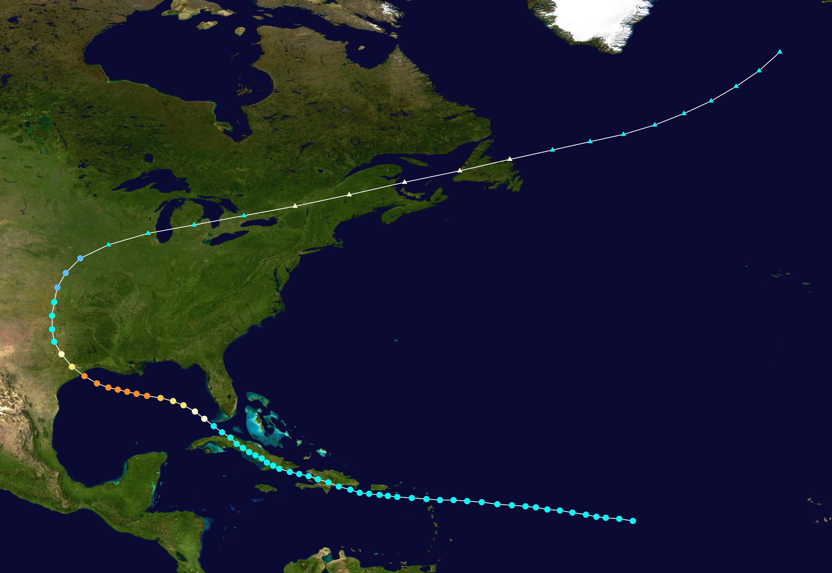
This is interesting. I hope this turns out not to be a good analog.

1900 Galveston Hurricane Track:

Image
2 likes   

User avatar
DestinHurricane
Category 4
Category 4
Posts: 935
Joined: Tue May 01, 2018 8:05 am
Location: New York, NY

Re: ATL: INVEST 98L - Discussion

#499 Postby DestinHurricane » Wed Aug 19, 2020 12:15 pm

Some convection firing to the north.
0 likes   
Michael 2018

User avatar
eastcoastFL
Category 5
Category 5
Posts: 3901
Age: 43
Joined: Thu Apr 12, 2007 12:29 pm
Location: Palm City, FL

Re: ATL: INVEST 98L - Discussion

#500 Postby eastcoastFL » Wed Aug 19, 2020 12:26 pm

captainbarbossa19 wrote:This is interesting. I hope this turns out not to be a good analog.

1900 Galveston Hurricane Track:

https://upload.wikimedia.org/wikipedia/commons/1/12/1900_Galveston_hurricane_track.png


Was that a cat 3?
0 likes   
Personal Forecast Disclaimer:
The posts in this forum are NOT official forecast and should not be used as such. They are just the opinion of the poster and may or may not be backed by sound meteorological data. They are NOT endorsed by any professional institution or storm2k.org. For official information, please refer to the NHC and NWS products.


Return to “2020”

Who is online

Users browsing this forum: No registered users and 12 guests