ATL: LAURA - Models
Moderator: S2k Moderators
-
supercane4867
- Category 5

- Posts: 4966
- Joined: Wed Nov 14, 2012 10:43 am
-
supercane4867
- Category 5
- Posts: 4966
- Joined: Wed Nov 14, 2012 10:43 am


-
SouthFLTropics

- Category 5
- Posts: 4258
- Age: 50
- Joined: Thu Aug 14, 2003 8:04 am
- Location: Port St. Lucie, Florida
Re: ATL: INVEST 98L - Models
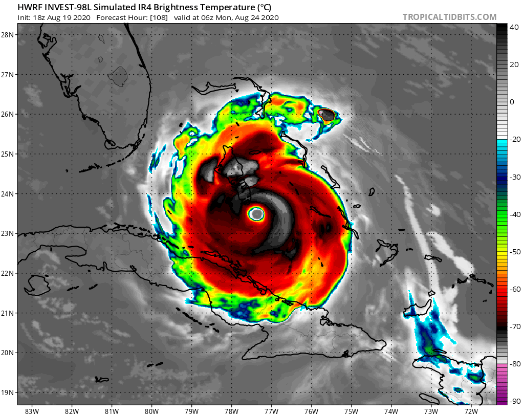
Key Largo, 942mb, 130 knots
Sent from my iPhone using Tapatalk
Sent from my iPhone using Tapatalk
0 likes
Fourth Generation Florida Native
Personal Storm History: David 79, Andrew 92, Erin 95, Floyd 99, Irene 99, Frances 04, Jeanne 04, Wilma 05, Matthew 16, Irma 17, Ian 22, Nicole 22, Milton 24
Personal Storm History: David 79, Andrew 92, Erin 95, Floyd 99, Irene 99, Frances 04, Jeanne 04, Wilma 05, Matthew 16, Irma 17, Ian 22, Nicole 22, Milton 24
-
EquusStorm
- Category 5
- Posts: 1649
- Age: 35
- Joined: Thu Nov 07, 2013 1:04 pm
- Location: Jasper, AL
- Contact:
Re: ATL: INVEST 98L - Models
Hard to believe less than a week ago everyone was asking when the models will even show a closed low somewhere in the tropics, now we have the opposite problem almost overnight
4 likes
Colors of lost purpose on the canvas of irrelevance
Not a meteorologist, in fact more of an idiot than anything. You should probably check with the NHC or a local NWS office for official information.
Not a meteorologist, in fact more of an idiot than anything. You should probably check with the NHC or a local NWS office for official information.
-
SconnieCane
- Category 5
- Posts: 1013
- Joined: Thu Aug 02, 2018 5:29 pm
- Location: Madison, WI
Re: ATL: INVEST 98L - Models

Well gang, the model stuff has arrived.
9 likes

Re: ATL: INVEST 98L - Models
Doesn't HWRF always show every storm turning into a major hurricane?
3 likes
-
jlauderdal
- S2K Supporter

- Posts: 7240
- Joined: Wed May 19, 2004 5:46 am
- Location: NE Fort Lauderdale
- Contact:
Re: RE: Re: ATL: INVEST 98L - Models
That is about as mean looking system we have seen heading towards dade county in awhilesupercane4867 wrote:Looks very CAT5-ish
4 likes
-
Hypercane_Kyle

- Category 5
- Posts: 3465
- Joined: Sat Mar 07, 2015 7:58 pm
- Location: Cape Canaveral, FL
Re: ATL: INVEST 98L - Models
Good thing the HWRF is never accurate in terms of intensity this far out.
I do think it's on to something with development of a TC in 24-48 hours, but beyond that nope.
I do think it's on to something with development of a TC in 24-48 hours, but beyond that nope.
2 likes
My posts are my own personal opinion, defer to the National Hurricane Center (NHC) and other NOAA products for decision making during hurricane season.
-
SconnieCane
- Category 5
- Posts: 1013
- Joined: Thu Aug 02, 2018 5:29 pm
- Location: Madison, WI
Re: ATL: INVEST 98L - Models
canes92 wrote:Doesn't HWRF always show every storm turning into a major hurricane?
It has a tendency to oversell cyclones (see: 777mb Mangkhut), but to its credit it was more reserved and pretty much spot-on with Isaias (other than 1 or 2 runs).
1 likes
-
supercane4867
- Category 5
- Posts: 4966
- Joined: Wed Nov 14, 2012 10:43 am
Re: ATL: INVEST 98L - Models
canes92 wrote:Doesn't HWRF always show every storm turning into a major hurricane?
Well it actually just dropped 97L and was never really bullish on it as far as I can remember.
1 likes
-
SouthFLTropics
- Category 5
- Posts: 4258
- Age: 50
- Joined: Thu Aug 14, 2003 8:04 am
- Location: Port St. Lucie, Florida
Re: ATL: INVEST 98L - Models
So the question remains...what does most every other model have that the GFS and Euro are lacking???
Sent from my iPhone using Tapatalk
Sent from my iPhone using Tapatalk
0 likes
Fourth Generation Florida Native
Personal Storm History: David 79, Andrew 92, Erin 95, Floyd 99, Irene 99, Frances 04, Jeanne 04, Wilma 05, Matthew 16, Irma 17, Ian 22, Nicole 22, Milton 24
Personal Storm History: David 79, Andrew 92, Erin 95, Floyd 99, Irene 99, Frances 04, Jeanne 04, Wilma 05, Matthew 16, Irma 17, Ian 22, Nicole 22, Milton 24
-
ConvergenceZone
.gif)
- Category 5
- Posts: 5241
- Joined: Fri Jul 29, 2005 1:40 am
- Location: Northern California
Re: ATL: INVEST 98L - Models
I know that its just the HWRF, so we shouldn’t pay attention to it,
but what’s concerning is that it keeps making the storm stronger and stronger
but what’s concerning is that it keeps making the storm stronger and stronger
0 likes
-
plasticup
Re: ATL: INVEST 98L - Models
supercane4867 wrote:130kt landfall. Also heading for the Gulf.
https://i.imgur.com/KiJcfHR.png
https://i.imgur.com/ZOjpjhj.png
Well that’s concerning
0 likes
-
eastcoastFL

- Category 5
- Posts: 3996
- Age: 44
- Joined: Thu Apr 12, 2007 12:29 pm
- Location: Palm City, FL
ATL: INVEST 98L - Discussion
18z HWRF has a major hitting extreme south Florida Monday night

4 likes
Personal Forecast Disclaimer:
The posts in this forum are NOT official forecast and should not be used as such. They are just the opinion of the poster and may or may not be backed by sound meteorological data. They are NOT endorsed by any professional institution or storm2k.org. For official information, please refer to the NHC and NWS products.
The posts in this forum are NOT official forecast and should not be used as such. They are just the opinion of the poster and may or may not be backed by sound meteorological data. They are NOT endorsed by any professional institution or storm2k.org. For official information, please refer to the NHC and NWS products.
Re: ATL: INVEST 98L - Models
Intensity is a crapshoot so we should not focus on it. What we should be concerned is that the majority of model runs and the ensembles, with the exception of GFS operational, have all been in agreement of taking 98L north of the islands without land interaction towards the Bahamas, in their most recent runs. That's what we should be more concerned about, not intensity.
4 likes
-
toad strangler

- S2K Supporter
- Posts: 4546
- Joined: Sun Jul 28, 2013 3:09 pm
- Location: Earth
- Contact:
Re: ATL: INVEST 98L - Models
Andy pours cold water on the 2nd tier of models ...
http://twitter.com/AndyHazelton/status/1296236633294069761
http://twitter.com/AndyHazelton/status/1296236633294069761
0 likes
My Weather Station
https://www.wunderground.com/dashboard/pws/KFLPORTS603
https://www.wunderground.com/dashboard/pws/KFLPORTS603
-
WeatherEmperor
- S2K Supporter
- Posts: 4806
- Age: 41
- Joined: Thu Sep 04, 2003 2:54 pm
- Location: South Florida
Re: ATL: INVEST 98L - Models
Does anybody have the 18z Euro??
Sent from my iPhone using Tapatalk
Sent from my iPhone using Tapatalk
0 likes
-
SFLcane

- S2K Supporter
- Posts: 10281
- Age: 48
- Joined: Sat Jun 05, 2010 1:44 pm
- Location: Lake Worth Florida
Re: ATL: INVEST 98L - Models
Help support Storm2K!

WeatherEmperor wrote:Does anybody have the 18z Euro??
Sent from my iPhone using Tapatalk
Nada..poof
Waiting on EPS
2 likes
Who is online
Users browsing this forum: No registered users and 16 guests