ATL: MARCO - Remnants - Discussion

Moderator: S2k Moderators

Message
Author
User avatar
ouragans
Category 1
Category 1
Posts: 490
Age: 53
Joined: Sun Jun 12, 2011 12:09 pm
Location: Abymes, Guadeloupe F.W.I
Contact:

Re: ATL: INVEST 97L - Discussion

#421 Postby ouragans » Thu Aug 20, 2020 8:35 am

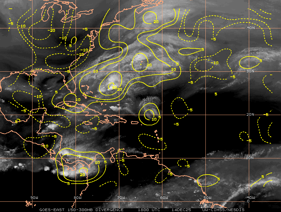
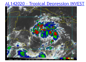
Aric Dunn wrote:So recon flies into 97L first before td13..

there is a distinct possibility that 97L may go straight to TS. and would become laura

I do think so. 97L has much better conditions now than DT13. I won't buy the PTC solution, neither DT14. My point is straight to TS, before DT13 is upgraded
2 likes   
Personal forecast disclaimer
This post is a personal point of view, not an information. Please refer to official statements for life-threatening decisions.

David '79, Frederic '79, Hugo '89, Iris, Luis & Marilyn '95, Georges '98, Lenny '99, Dean '07, Irma '17, Maria '17, Fiona '22, Philippe '23, Tammy '23
16°13'33.3,"6N -61°36'39.5"W

User avatar
Cataegis96
Professional-Met
Professional-Met
Posts: 54
Age: 29
Joined: Mon Jul 10, 2017 3:46 pm
Contact:

Re: ATL: INVEST 97L - Discussion

#422 Postby Cataegis96 » Thu Aug 20, 2020 8:36 am

Image

Nice area of upper level divergence colocated with the deepest convection and developing COC. Another indicator of a well placed upper level anticyclone.
3 likes   
Lead Meteorologist Mars, Inc
WE ARE! The Pennsylvania State University 2018
UA U KNOW! University at Albany, SUNY 2020

TallyTracker
Category 2
Category 2
Posts: 734
Joined: Thu Oct 11, 2018 2:46 pm

Re: ATL: INVEST 97L - Discussion

#423 Postby TallyTracker » Thu Aug 20, 2020 8:38 am

It’s looking good on visible satellite this morning. But the big question with these waves is always what’s under the hood? I see evidence of a closed low level circulation with westward moving low level clouds on the southern flank, but it’s hard to tell. I believe Dolly 2010 was a good example of a wave that looked great on satellite, but took days to develop a closed circulation.
0 likes   
Fran '96, Georges '98, Gordon '00, Gabrielle '01, Charley '04, Frances '04, Jeanne '04, Barry '07, Fay '08, Debby '12, Matthew '16, Emily '17, Irma '17, Michael ‘18, Elsa ‘21, Fred ‘21, Mindy ‘21, Nicole ‘22, Idalia ‘23, Debby ‘24, Helene ‘24

User avatar
Steve
S2K Supporter
S2K Supporter
Posts: 9621
Joined: Sat Apr 05, 2003 11:41 pm
Location: Not a state-caster

Re: ATL: INVEST 97L - Discussion

#424 Postby Steve » Thu Aug 20, 2020 8:43 am

Kazmit wrote:I don't ever recall two TCs being in the gulf simultaneously, has that happened before?


Seems like it’s happened a few times over the years but I can’t cite an example. I don’t remember if Hermine and Georges were or not which might be the last time. But I can’t remember.
0 likes   

User avatar
gfsperpendicular
Category 1
Category 1
Posts: 383
Age: 21
Joined: Mon Jun 19, 2017 3:04 pm
Location: Northern Virginia

Re: ATL: INVEST 97L - Discussion

#425 Postby gfsperpendicular » Thu Aug 20, 2020 8:56 am

Steve wrote:
Kazmit wrote:I don't ever recall two TCs being in the gulf simultaneously, has that happened before?


Seems like it’s happened a few times over the years but I can’t cite an example. I don’t remember if Hermine and Georges were or not which might be the last time. But I can’t remember.


I think Bonnie and Charley in 2004 were in the gulf at the same time, but Bonnie might've been a depression by the time Charley entered. Can't think of any more recent ones off the top of my head.
2 likes   
I'm not sleeping, I'm waiting for the 0900 UTC advisory!

#1 CMC stan

User avatar
Nancy Smar
Category 5
Category 5
Posts: 1081
Age: 24
Joined: Wed Aug 16, 2017 10:03 pm

Re: ATL: INVEST 97L - Discussion

#426 Postby Nancy Smar » Thu Aug 20, 2020 8:57 am

AL142020 - Tropical Depression INVEST
11 likes   

zhukm29
Category 1
Category 1
Posts: 279
Joined: Tue Aug 28, 2018 2:37 pm

Re: ATL: INVEST 97L - Discussion

#427 Postby zhukm29 » Thu Aug 20, 2020 9:05 am

Nancy Smar wrote:
AL142020 - Tropical Depression INVEST


Looks increasingly likely this this may steal Laura simply because recon will be going in first (TD13 won't get recon until tonight). Looks like Marco will be the one axed from the list this year if a few TD13 model runs verify (RIP Marco and Polo). :lol:
0 likes   

User avatar
Laminar
Tropical Storm
Tropical Storm
Posts: 169
Joined: Mon Sep 10, 2018 11:42 am
Location: Ambergris Caye Belize

Re: ATL: INVEST 97L - Discussion

#428 Postby Laminar » Thu Aug 20, 2020 9:05 am

How much of a recurring factor is the Rossby Wave? I don’t recall us talking this much about it for the last five or six years. Is it different to a usual season in its positioning? Would appreciate some knowledge if anyone wants to share!
Last edited by Laminar on Thu Aug 20, 2020 9:06 am, edited 1 time in total.
0 likes   
FAA ATP
Belize UAS Operator

User avatar
cainjamin
Tropical Storm
Tropical Storm
Posts: 168
Age: 34
Joined: Mon Apr 17, 2017 1:38 pm
Location: Nova Scotia, Canada

Re: ATL: INVEST 97L - Discussion

#429 Postby cainjamin » Thu Aug 20, 2020 9:06 am

Looks like we have TD 14. Now it will be a race for who gets to be named Laura. My money is on TD 14!
2 likes   
Noel '07, Kyle '08, Earl '10, Arthur '14, Dorian '19, Teddy '20, Lee '23

User avatar
DorkyMcDorkface
Category 3
Category 3
Posts: 888
Age: 27
Joined: Mon Sep 30, 2019 1:32 pm
Location: Mid-Atlantic

Re: ATL: INVEST 97L - Discussion

#430 Postby DorkyMcDorkface » Thu Aug 20, 2020 9:10 am

Nancy Smar wrote:
AL142020 - Tropical Depression INVEST

Can confirm on RAMMB. Last night had a similar situation with TD13 (formerly 98L) and it ended up getting upgraded shortly afterwards.

Image
0 likes   
Please note the thougths expressed by this account are solely those of the user and are from a hobbyist perspective. For more comprehensive analysis, consult an actual professional meteorologist or meteorology agency.


Floyd 1999 | Isabel 2003 | Hanna 2008 | Irene 2011 | Sandy 2012 | Isaias 2020

User avatar
GCANE
S2K Supporter
S2K Supporter
Posts: 11497
Joined: Mon Oct 22, 2007 8:03 am

Re: ATL: INVEST 97L - Discussion

#431 Postby GCANE » Thu Aug 20, 2020 9:13 am

Strong convection with heavy lightning along the dryline.
Advancing into the dry slot.
I expect the dry air should be washed out within 24 hrs.

Image
2 likes   

User avatar
Nancy Smar
Category 5
Category 5
Posts: 1081
Age: 24
Joined: Wed Aug 16, 2017 10:03 pm

Re: ATL: INVEST 97L - Discussion

#432 Postby Nancy Smar » Thu Aug 20, 2020 9:16 am

AL, 14, 2020082012, , BEST, 0, 150N, 790W, 30, 1007, TD, 34, NEQ, 0, 0, 0, 0, 1011, 150, 70, 0, 0, L, 0, , 0, 0, FOURTEEN, M, 0, , 0, 0, 0, 0, genesis-num, 027, TRANSITIONED, alB72020 to al142020,
0 likes   

User avatar
cycloneye
Admin
Admin
Posts: 145348
Age: 68
Joined: Thu Oct 10, 2002 10:54 am
Location: San Juan, Puerto Rico

Re: ATL: INVEST 97L - Discussion

#433 Postby cycloneye » Thu Aug 20, 2020 9:18 am

NHC will initiate advisories on Tropical Depression Fourteen, located in the Caribbean Sea, at 11 AM EDT (1500 UTC).
7 likes   
Visit the Caribbean-Central America Weather Thread where you can find at first post web cams,radars
and observations from Caribbean basin members Click Here

Aric Dunn
Category 5
Category 5
Posts: 21238
Age: 42
Joined: Sun Sep 19, 2004 9:58 pm
Location: Ready for the Chase.
Contact:

Re: ATL: INVEST 97L - Discussion

#434 Postby Aric Dunn » Thu Aug 20, 2020 9:18 am

Td 14 it is.. now lets see if recon finds a TS in a couple hours.
Last edited by Aric Dunn on Thu Aug 20, 2020 9:19 am, edited 1 time in total.
0 likes   
Note: If I make a post that is brief. Please refer back to previous posts for the analysis or reasoning. I do not re-write/qoute what my initial post said each time.
If there is nothing before... then just ask :)

Space & Atmospheric Physicist, Embry-Riddle Aeronautical University,
I believe the sky is falling...

xironman
S2K Supporter
S2K Supporter
Posts: 2522
Joined: Sun Jun 10, 2007 4:53 pm
Location: NoVA

Re: ATL: INVEST 97L - Discussion

#435 Postby xironman » Thu Aug 20, 2020 9:18 am

Laminar wrote:How much of a recurring factor is the Rossby Wave? I don’t recall us talking this much about it for the last five or six years. Is it different to a usual season in its positioning? Would appreciate some knowledge if anyone wants to share!


The longwave weather pattern is a Rossby wave, as opposed to shortwaves. https://www.weather.gov/jetstream/longshort
2 likes   

User avatar
GCANE
S2K Supporter
S2K Supporter
Posts: 11497
Joined: Mon Oct 22, 2007 8:03 am

Re: ATL: INVEST 97L - Discussion

#436 Postby GCANE » Thu Aug 20, 2020 9:21 am

A building Theta-E ridge to the NW.
Tracking into one of these and RI is very likely.
Stay tuned.

Image
6 likes   

User avatar
PTrackerLA
Category 5
Category 5
Posts: 5277
Age: 41
Joined: Thu Oct 10, 2002 8:40 pm
Location: Lafayette, LA

Re: ATL: FOURTEEN - Tropical Depression - Discussion

#437 Postby PTrackerLA » Thu Aug 20, 2020 9:27 am

Oh boy did not expect this so soon, August 20th has done it's magic. Anxious to see what NHC does with the track/intensity.
3 likes   

User avatar
Hypercane_Kyle
Category 5
Category 5
Posts: 3352
Joined: Sat Mar 07, 2015 7:58 pm
Location: Cape Canaveral, FL

Re: ATL: FOURTEEN - Tropical Depression - Discussion

#438 Postby Hypercane_Kyle » Thu Aug 20, 2020 9:33 am

Two missed genesis forecasts by the ECMWF in a single day.

Not a good look for the model.

14L looks well organized, too.

Image
10 likes   
My posts are my own personal opinion, defer to the National Hurricane Center (NHC) and other NOAA products for decision making during hurricane season.

User avatar
wxman57
Moderator-Pro Met
Moderator-Pro Met
Posts: 22979
Age: 67
Joined: Sat Jun 21, 2003 8:06 pm
Location: Houston, TX (southwest)

Re: ATL: FOURTEEN - Tropical Depression - Discussion

#439 Postby wxman57 » Thu Aug 20, 2020 9:35 am

I'll say this TD Fourteen looks much more impressive than TD Thirteen. I'm not sure if Thirteen has an LLC. It's really sucking in a lot of dry dusty air.
9 likes   

User avatar
GCANE
S2K Supporter
S2K Supporter
Posts: 11497
Joined: Mon Oct 22, 2007 8:03 am

Re: ATL: FOURTEEN - Tropical Depression - Discussion

#440 Postby GCANE » Thu Aug 20, 2020 9:40 am

PV Streamer from the TUTT will likely shred TD13 and enhance ventilation for TD14.
The streamer is taking a really deep dive south.
I thought it would develop a couple days ago but not go this far south.
If we start seeing a strong poleward outflow channel on TD14 kick in, it is very likely the lid comes off.
Especially if the theta-e ridge holds up.
Strong convection is already firing off in it.
2 likes   


Return to “2020”

Who is online

Users browsing this forum: No registered users and 8 guests