
18Z GFS on approach, showing the ridge slightly stronger.
Big kicker, its hanging more inside the AWRB.
Indicates shear would likely be less on landfall, hence a stronger Laura.
Areas around Houston get your everything together.
ATL: LAURA - Post-Tropical - Discussion
Moderator: S2k Moderators
-
cheezyWXguy

- Category 5

- Posts: 6282
- Joined: Mon Feb 13, 2006 12:29 am
- Location: Dallas, TX
Re: ATL: LAURA - Hurricane - Discussion
GCANE wrote:18Z GFS on approach, showing the ridge slightly stronger.
Big kicker, its hanging more inside the AWRB.
Indicates shear would likely be less on landfall, hence a stronger Laura.
Areas around Houston get your everything together.
Are you thinking the path should end up west of what the gfs shows, given its depiction of the high?
0 likes
-
IsabelaWeather
- Category 1

- Posts: 316
- Age: 36
- Joined: Tue Jul 07, 2020 7:29 am
- Location: Isabela, Puerto Rico
Re: ATL: LAURA - Hurricane - Discussion
Blow_Hard wrote:Blinhart wrote:Ok, just finished with doing the sand bags to the back door, cleaned out the gutters, and brought in the majority of all furniture from outside. Tomorrow morning after waking up and seeing what is going on, will decided if I need to sand bag the 2 front doors, got a old shower door to dam up my back french doors. Hopefully I won't have to do those things and this thing will be going closer to Houston than closer to me.
I'm sure you already know to do this but please make sure to take photos all around the exterior and interior of your house for Insurance purposes.
This is interesting. I do flood adjusting so I am thinking I will get sent out. Taking pics during the flood helps the most. (Of course if you are in evacuation zone, dont stay)
2 likes
-
ColdMiser123

- Professional-Met

- Posts: 905
- Age: 29
- Joined: Mon Sep 26, 2016 3:26 pm
- Location: Northeast US
Re: ATL: LAURA - Hurricane - Discussion
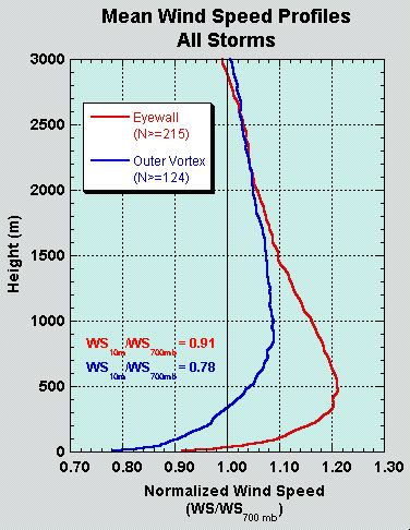
NotoSans wrote:NOAA aircraft has descended to flight-level and is about to conduct a NW-SE pass. Note that it's doing a non-standard 750mb mission so the conversion factor applicable to flight-level winds would be slightly lower than 0.9.
Plane is flying at ~2500 meters, which means we would expect to see winds around ~1.04 times what we would typically see at 700 hPa (~3000 meters), and this implies a ~0.86 to ~0.87 conversion factor to estimate surface wind in the eyewall.
10 likes
B.S., M.S., Meteorology & Atmospheric Science
-
eastcoastFL

- Category 5
- Posts: 3996
- Age: 44
- Joined: Thu Apr 12, 2007 12:29 pm
- Location: Palm City, FL
Re: ATL: LAURA - Hurricane - Discussion
Laura has taken over the gulf. It’s her show now

10 likes
Personal Forecast Disclaimer:
The posts in this forum are NOT official forecast and should not be used as such. They are just the opinion of the poster and may or may not be backed by sound meteorological data. They are NOT endorsed by any professional institution or storm2k.org. For official information, please refer to the NHC and NWS products.
The posts in this forum are NOT official forecast and should not be used as such. They are just the opinion of the poster and may or may not be backed by sound meteorological data. They are NOT endorsed by any professional institution or storm2k.org. For official information, please refer to the NHC and NWS products.
-
Rail Dawg
- S2K Supporter

- Posts: 326
- Joined: Mon Aug 27, 2012 5:02 pm
- Location: Where the eye makes landfall.
Re: ATL: LAURA - Hurricane - Discussion
Am going to head for Sabine Pass and check out Cameron, LA at some point soon. This is going to be a recon mission in but will only make a stand in a parking garage closest to the eye.
This is a video from the Michael chasers I warned to stay in the Panama City parking garage with me. They did not listen. If they are on this forum please know I am not being critical. I understand the chase and over 14 hurricanes have become older and wiser.
[Youtube]https://www.youtube.com/watch?v=_XA5OQHWx1Y[/Youtube]
5 likes
Although I have been a hurricane forecaster since 1980 that only means I've been wrong lots of times.
-
TallyTracker
- Category 2

- Posts: 787
- Joined: Thu Oct 11, 2018 2:46 pm
Re: ATL: LAURA - Hurricane - Discussion
BobHarlem wrote:IsabelaWeather wrote:jlauderdal wrote:If you are chasing them, you dont always get a cozy place to hangout like a parking garage...good chasers find it and stay alive, natural or manamade structures.
The Cameron area is a literal death sentence to chase. There is nothing there to protect you from surge or wind. There are also very, very few roads. I would not leave Sabine Pass.
Mark Sudduth put a remote camera in Cameron, and is setting one up in Holly Beach right now, but not hanging around there for it.
https://www.youtube.com/watch?v=51j0t6L ... e=youtu.be
Mark does it right! I love his approach. The video he got of Mexico Beach during Michael both gave me chills and made me sick at the same time.
4 likes
Fran '96, Georges '98, Gordon '00, Gabrielle '01, Charley '04, Frances '04, Jeanne '04, Barry '07, Fay '08, Debby '12, Matthew '16, Emily '17, Irma '17, Michael ‘18, Elsa ‘21, Fred ‘21, Mindy ‘21, Nicole ‘22, Idalia ‘23, Debby ‘24, Helene ‘24
-
IsabelaWeather
- Category 1
- Posts: 316
- Age: 36
- Joined: Tue Jul 07, 2020 7:29 am
- Location: Isabela, Puerto Rico
Re: ATL: LAURA - Hurricane - Discussion
BobHarlem wrote:IsabelaWeather wrote:jlauderdal wrote:If you are chasing them, you dont always get a cozy place to hangout like a parking garage...good chasers find it and stay alive, natural or manamade structures.
The Cameron area is a literal death sentence to chase. There is nothing there to protect you from surge or wind. There are also very, very few roads. I would not leave Sabine Pass.
Mark Sudduth put a remote camera in Cameron, and is setting one up in Holly Beach right now, but not hanging around there for it.
https://www.youtube.com/watch?v=51j0t6L ... e=youtu.be
Brings back memories. My wife and I took our RV and stayed on Holly Beach for a few days. Drove all over the area, watching Mark drive around brings back memories. I wonder how much different the landscape will be in 48 hours.
1 likes

Re: ATL: LAURA - Hurricane - Discussion
Rail Dawg wrote:Am going to head for Sabine Pass and check out Cameron, LA at some point soon. This is going to be a recon mission in but will only make a stand in a parking garage closest to the eye.
This is a video from the Michael chasers I warned to stay in the Panama City parking garage with me. They did not listen. If they are on this forum please know I am not being critical. I understand the chase and over 14 hurricanes have become older and wiser.
https://www.youtube.com/watch?v=_XA5OQHWx1Y
You won't actually be able to get to Cameron from Sabine Pass (there is a ferry, but I don't know if it is running), but it isn't that far of a drive, if you drive up from Holly Beach, you might find a spot around Hackberry.
1 likes
Personal Forecast Disclaimer:
The posts in this forum are NOT official forecast and should not be used as such. They are just the opinion of the poster and may or may not be backed by sound meteorological data. They are NOT endorsed by any professional institution or storm2k.org. For official information, please refer to the NHC and NWS products.
The posts in this forum are NOT official forecast and should not be used as such. They are just the opinion of the poster and may or may not be backed by sound meteorological data. They are NOT endorsed by any professional institution or storm2k.org. For official information, please refer to the NHC and NWS products.
-
cfisher
Re: ATL: LAURA - Hurricane - Discussion
IsabelaWeather wrote:BobHarlem wrote:IsabelaWeather wrote:
The Cameron area is a literal death sentence to chase. There is nothing there to protect you from surge or wind. There are also very, very few roads. I would not leave Sabine Pass.
Mark Sudduth put a remote camera in Cameron, and is setting one up in Holly Beach right now, but not hanging around there for it.
https://www.youtube.com/watch?v=51j0t6L ... e=youtu.be
Brings back memories. My wife and I took our RV and stayed on Holly Beach for a few days. Drove all over the area, watching Mark drive around brings back memories. I wonder how much different the landscape will be in 48 hours.
Most likely underwater with all the buildings from Holly Beach miles inland just like Rita did.
1 likes
Personal Forecast Disclaimer:
The posts in this forum are NOT official forecast and should not be used as such. They are just the opinion of the poster and may or may not be backed by sound meteorological data. They are NOT endorsed by any professional institution or storm2k.org. For official information, please refer to the NHC and NWS products.
The posts in this forum are NOT official forecast and should not be used as such. They are just the opinion of the poster and may or may not be backed by sound meteorological data. They are NOT endorsed by any professional institution or storm2k.org. For official information, please refer to the NHC and NWS products.
-
ColdMiser123
- Professional-Met
- Posts: 905
- Age: 29
- Joined: Mon Sep 26, 2016 3:26 pm
- Location: Northeast US
Re: ATL: LAURA - Hurricane - Discussion
Interested to see how asymmetric the structure still is.
Eastern semicircle will almost certainly be stronger, but any progress on the western side would indicate an inner core making steps toward closing off, and a prelude to potential steeper intensification.
Eastern semicircle will almost certainly be stronger, but any progress on the western side would indicate an inner core making steps toward closing off, and a prelude to potential steeper intensification.
1 likes
B.S., M.S., Meteorology & Atmospheric Science
-
FLpanhandle91

- Category 5
- Posts: 1039
- Age: 34
- Joined: Mon Sep 13, 2010 3:50 pm
- Location: Fort Walton Beach, FL
Re: ATL: LAURA - Hurricane - Discussion
ColdMiser123 wrote:Interested to see how asymmetric the structure still is.
Eastern semicircle will almost certainly be stronger, but any progress on the western side would indicate an inner core making progress toward closing off, and a prelude to potential steeper intensification.
As you typed this, brand new hot tower racing around to close off the western eyewall.
0 likes
-
jlauderdal
- S2K Supporter
- Posts: 7240
- Joined: Wed May 19, 2004 5:46 am
- Location: NE Fort Lauderdale
- Contact:
Re: ATL: LAURA - Hurricane - Discussion
BobHarlem wrote:IsabelaWeather wrote:jlauderdal wrote:If you are chasing them, you dont always get a cozy place to hangout like a parking garage...good chasers find it and stay alive, natural or manamade structures.
Lets see where josh ends up
The Cameron area is a literal death sentence to chase. There is nothing there to protect you from surge or wind. There are also very, very few roads. I would not leave Sabine Pass.
Mark Sudduth put a remote camera in Cameron, and is setting one up in Holly Beach right now, but not hanging around there for it.
https://www.youtube.com/watch?v=51j0t6L ... e=youtu.be
0 likes
-
shiny-pebble
- Category 1
- Posts: 299
- Joined: Thu Jul 05, 2018 1:38 pm
Re: ATL: LAURA - Hurricane - Discussion
Lots of hot towers firing off in the Northwest.... Should have a closed core soon...
Sent from my SM-G970U using Tapatalk
Sent from my SM-G970U using Tapatalk
0 likes
Not an meteorologist! Just someone who is interested in weather. Please refer to the NHC and local weather officials to make decisions.
-Jack
-Jack
-
ColdMiser123
- Professional-Met
- Posts: 905
- Age: 29
- Joined: Mon Sep 26, 2016 3:26 pm
- Location: Northeast US
Re: ATL: LAURA - Hurricane - Discussion
Significantly stronger NW side compared to earlier passes this morning, even taking the slightly higher wind conversion into account.
1 likes
B.S., M.S., Meteorology & Atmospheric Science
-
cfisher
Re: ATL: LAURA - Hurricane - Discussion
ADT has the track at 300/14 so a little more north and perhaps a little slower than expected.
0 likes

Re: ATL: LAURA - Hurricane - Discussion
eastcoastFL wrote:Laura has taken over the gulf. It’s her show now
https://cdn.star.nesdis.noaa.gov/FLOATER/data/AL132020/16/GOES16-AL132020-16-1000x1000.gif?hash=21453
Can I have the URL for this loop? Can't find this angle on the NOAA site.
1 likes
-
supercane4867
- Category 5
- Posts: 4966
- Joined: Wed Nov 14, 2012 10:43 am
Re: ATL: LAURA - Hurricane - Discussion
Central pressure is probably 985mb or below. Should get the reading in the next set of data.
2 likes
Who is online
Users browsing this forum: No registered users and 8 guests