This is a high school kid. Not that there is anything wrong with that
2020 Indicators: SST's / SAL / MSLP / Steering / Shear / Instability / Sat Images
Moderator: S2k Moderators
Forum rules

The posts in this forum are NOT official forecasts and should not be used as such. They are just the opinion of the poster and may or may not be backed by sound meteorological data. They are NOT endorsed by any professional institution or STORM2K. For official information, please refer to products from the National Hurricane Center and National Weather Service.
-
toad strangler

- S2K Supporter

- Posts: 4546
- Joined: Sun Jul 28, 2013 3:09 pm
- Location: Earth
- Contact:
Re: 2020 Indicators: SST's / SAL / MSLP / Steering / Shear / Instability / Sat Images
This is a high school kid. Not that there is anything wrong with that
0 likes
My Weather Station
https://www.wunderground.com/dashboard/pws/KFLPORTS603
https://www.wunderground.com/dashboard/pws/KFLPORTS603

Re: 2020 Indicators: SST's / SAL / MSLP / Steering / Shear / Instability / Sat Images
cheezyWXguy wrote:Steve wrote:cheezyWXguy wrote:That was me, haha, or at least I was one of them. In my opinion, if the message he is trying to convey was related to ace as well as impacts, he should be outlining ocean areas as well as coastal areas and say, “these are the areas where I expect >50% of total ace to occur.” It would make much more of a statement to highlight the northern Caribbean, Gulf of Mexico, and east of Florida with risk areas while excluding the rest of the Atlantic, since it would be a more definitive deviation from climatology and more specific to this season.
I think that's what it says? He says (> 50% of total activity). I guess that's technically ambiguous and /= "ACE" necessarily. So I see that point now. https://www.weatherbell.com/may-2020-hu ... son-update
Oof. That’s what I get for making a claim without going back and checking the diagram first. I retract my statement. My false memory was that only the areas in red were highlighted at all. I would update my criticism to say he’s still quite generous with the red, but it’s not as bad as I remember.
As far as the map goes, he was just another indicator of a season weighted to the Western Atlantic. He’s been good there though we have a long way to go in the season. Another note from that forecast was the anticipation of the strong MJO signals. Last time it was down in 2 and spent a few days there (time before Laura), there wasn’t that much activity. But this time we got a Cat 4. What I understood was that he thought it would spend more time in 2/3. We have a couple days in 3, then it’s going back in the circle. So that remains to be seen in September and October as to how strong of a signal and does maybe a building La Niña take over as the dominant signal overall. Maybe they’ll work together at times. ?
1 likes

Re: 2020 Indicators: SST's / SAL / MSLP / Steering / Shear / Instability / Sat Images
Nothing is going to form in MDR with this thing. It will only push everything west. Not good. I don't buy the models with quick development. Plus it will squeeze the Bermuda ridge and pump it up.
https://twitter.com/pppapin/status/1300572652453736448
https://twitter.com/pppapin/status/1300572652453736448
0 likes
The following post is NOT an official forecast and should not be used as such. It is just the opinion of the poster and may or may not be backed by sound meteorological data. It is NOT endorsed by any professional institution including storm2k.org For Official Information please refer to the NHC and NWS products.

Re: 2020 Indicators: SST's / SAL / MSLP / Steering / Shear / Instability / Sat Images
blp wrote:Nothing is going to form in MDR with this thing. It will only push everything west. Not good. I don't buy the models with quick development. Plus it will squeeze the Bermuda ridge and pump it up.
https://twitter.com/pppapin/status/1300572652453736448?s=20
That looks completely opposite the favorable conditions we were supposed to expect for September. Makes me wonder if we see a front-loaded season similar to 1990 followed by things picking back up again in October, or something like 2000 where the peak is delayed.
0 likes
The above post is not official and should not be used as such. It is the opinion of the poster and may or may not be backed by sound meteorological data. It is not endorsed by any professional institution or storm2k.org. For official information, please refer to the NHC and NWS products.

Re: 2020 Indicators: SST's / SAL / MSLP / Steering / Shear / Instability / Sat Images
Hammy wrote:blp wrote:Nothing is going to form in MDR with this thing. It will only push everything west. Not good. I don't buy the models with quick development. Plus it will squeeze the Bermuda ridge and pump it up.
https://twitter.com/pppapin/status/1300572652453736448?s=20
That looks completely opposite the favorable conditions we were supposed to expect for September. Makes me wonder if we see a front-loaded season similar to 1990 followed by things picking back up again in October, or something like 2000 where the peak is delayed.
Yeaaaaa..I’m not buying alot of this. It all seems to good to be true. There’s season cancelling, and there’s innocent wishful thinking (albeit educated wishful thinking!, but still). This season’s not gonna bust no matter how much people try to look into it. But I do agree with them that it’s more possible that development could be mostly westward.......juuuussttt like 2005..And sadly thats makes storms like Katrina, Rita, and Wilma wayyyy more possible
6 likes
-
TheStormExpert
Re: 2020 Indicators: SST's / SAL / MSLP / Steering / Shear / Instability / Sat Images
Hammy wrote:blp wrote:Nothing is going to form in MDR with this thing. It will only push everything west. Not good. I don't buy the models with quick development. Plus it will squeeze the Bermuda ridge and pump it up.
https://twitter.com/pppapin/status/1300572652453736448?s=20
That looks completely opposite the favorable conditions we were supposed to expect for September. Makes me wonder if we see a front-loaded season similar to 1990 followed by things picking back up again in October, or something like 2000 where the peak is delayed.
What a HUGE bust that would if so. Can’t believe two recurving typhoons can have HUGE implications on the Atlantic in this way.
0 likes
-
toad strangler
- S2K Supporter
- Posts: 4546
- Joined: Sun Jul 28, 2013 3:09 pm
- Location: Earth
- Contact:
Re: 2020 Indicators: SST's / SAL / MSLP / Steering / Shear / Instability / Sat Images
TheStormExpert wrote:Hammy wrote:blp wrote:Nothing is going to form in MDR with this thing. It will only push everything west. Not good. I don't buy the models with quick development. Plus it will squeeze the Bermuda ridge and pump it up.
https://twitter.com/pppapin/status/1300572652453736448?s=20
That looks completely opposite the favorable conditions we were supposed to expect for September. Makes me wonder if we see a front-loaded season similar to 1990 followed by things picking back up again in October, or something like 2000 where the peak is delayed.
What a HUGE bust that would if so. Can’t believe two recurving typhoons can have HUGE implications on the Atlantic in this way.
Yep, there have never been re-curving W PAC typhoons before. THis is all so new.
1 likes
My Weather Station
https://www.wunderground.com/dashboard/pws/KFLPORTS603
https://www.wunderground.com/dashboard/pws/KFLPORTS603
-
MarioProtVI
- Category 5

- Posts: 1034
- Age: 24
- Joined: Sun Sep 29, 2019 7:33 pm
- Location: New Jersey
Re: 2020 Indicators: SST's / SAL / MSLP / Steering / Shear / Instability / Sat Images
blp wrote:Nothing is going to form in MDR with this thing. It will only push everything west. Not good. I don't buy the models with quick development. Plus it will squeeze the Bermuda ridge and pump it up.
https://twitter.com/pppapin/status/1300572652453736448?s=20
Actually for what it’s worth the GFS (on the latest run) shows the strong shear from that TUTT just clipping the northern part of the MDR while pretty much killing the subtropics, but leaving the rest of it okay albeit a bit semi-light to fairly moderate shear (~10-15 maybe 20 kt max). If anything forms in the MDR it’ll have stay stay at like ~15–17N as that’s where shear is lower and to not get completely blasted by the shear during that time, and given the strong ridge this could happen. The massive TUTT seems to clear up by mid-September. This is why I would not write off CV season yet and already proclaiming September will be dead or inactive.
7 likes
-
TheStormExpert
Re: 2020 Indicators: SST's / SAL / MSLP / Steering / Shear / Instability / Sat Images
MarioProtVI wrote:blp wrote:Nothing is going to form in MDR with this thing. It will only push everything west. Not good. I don't buy the models with quick development. Plus it will squeeze the Bermuda ridge and pump it up.
https://twitter.com/pppapin/status/1300572652453736448?s=20
Actually for what it’s worth the GFS (on the latest run) shows the strong shear from that TUTT just clipping the northern part of the MDR while pretty much killing the subtropics, but leaving the rest of it okay albeit a bit semi-light to fairly moderate shear (~10-15 maybe 20 kt max). If anything forms in the MDR it’ll have stay stay at like ~15–17N as that’s where shear is lower and to not get completely blasted by the shear during that time, and given the strong ridge this could happen. The massive TUTT seems to clear up by mid-September. This is why I would not write off CV season yet and already proclaiming September will be dead or inactive.
Cape Verde season wraps up in late-September though. May be too late to produce any long-tracking storms.
1 likes
Re: 2020 Indicators: SST's / SAL / MSLP / Steering / Shear / Instability / Sat Images
TheStormExpert wrote:MarioProtVI wrote:blp wrote:Nothing is going to form in MDR with this thing. It will only push everything west. Not good. I don't buy the models with quick development. Plus it will squeeze the Bermuda ridge and pump it up.
https://twitter.com/pppapin/status/1300572652453736448?s=20
Actually for what it’s worth the GFS (on the latest run) shows the strong shear from that TUTT just clipping the northern part of the MDR while pretty much killing the subtropics, but leaving the rest of it okay albeit a bit semi-light to fairly moderate shear (~10-15 maybe 20 kt max). If anything forms in the MDR it’ll have stay stay at like ~15–17N as that’s where shear is lower and to not get completely blasted by the shear during that time, and given the strong ridge this could happen. The massive TUTT seems to clear up by mid-September. This is why I would not write off CV season yet and already proclaiming September will be dead or inactive.
Cape Verde season wraps up in late-September though. May be too late to produce any long-tracking storms.
Honestly we don’t need any though
For ex: the only Cape Verde storm in 2005 to become a major was Emily..in July (and kinda Dennis but it didn’t really form until it reached the eastern Caribbean). Most of the ACE that year came from the gulf and the sea, in fact October that year produced TWO majors in the later half of the month, one of them being the most intense in the Atlantic.
I hope someone can bring other years to demonstrate that you don’t need Cape Verde storms for hyperactivity.
Point being, we may still get a couple Cape Verde storms, but I def think we have huge possibilities of getting powerful Gulf and Caribbean storms in September and even a strong possibility of a crazy October too!
4 likes

Re: 2020 Indicators: SST's / SAL / MSLP / Steering / Shear / Instability / Sat Images
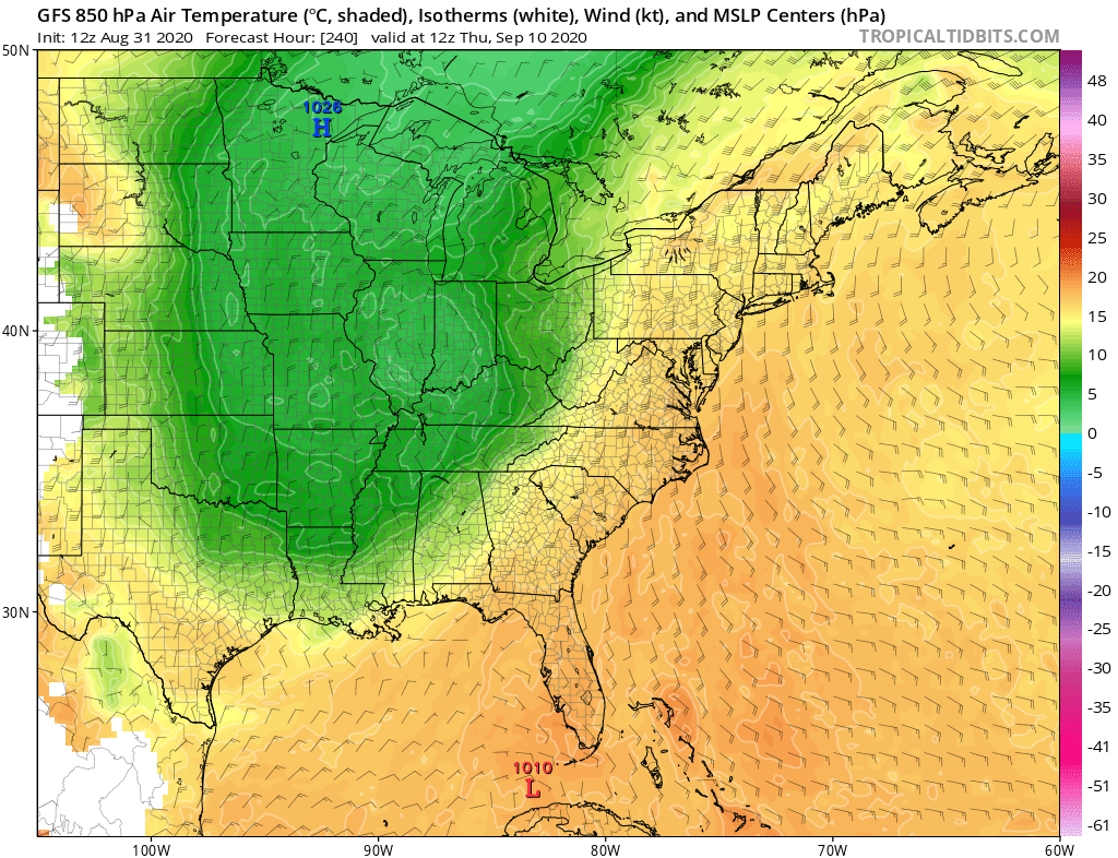
gatorcane wrote:Aric Dunn wrote:How is this indicator for you.. lol
euro..
40s and 50 into the gulf of mexico in earlt September. lol
rigghttt..
lol season canceled now right ?
https://www.tropicaltidbits.com/analysis/models/ecmwf/2020083112/ecmwf_T850_eus_11.png
Surprisingly the GFS isn’t much different. Recurving typhoons to blame?
https://i.postimg.cc/9MBfqf27/gfs-T850-eus-41.png
Like I have said, we can have all the troughs come down the plains into the MS river valley, but if they don't keep progressing east the Atlantic/Bermuda ridge will still hold strong and the threat to the US will continue like it happened last week with Laura.
I would feel safer with a pattern of a big ridge over the southern plains/MS river valley and a huge trough either in the NE US or east of the US Coast.

2 likes
-
Aric Dunn
- Category 5
- Posts: 21238
- Age: 43
- Joined: Sun Sep 19, 2004 9:58 pm
- Location: Ready for the Chase.
- Contact:
Re: 2020 Indicators: SST's / SAL / MSLP / Steering / Shear / Instability / Sat Images
NDG wrote:gatorcane wrote:Aric Dunn wrote:How is this indicator for you.. lol
euro..
40s and 50 into the gulf of mexico in earlt September. lol
rigghttt..
lol season canceled now right ?
https://www.tropicaltidbits.com/analysis/models/ecmwf/2020083112/ecmwf_T850_eus_11.png
Surprisingly the GFS isn’t much different. Recurving typhoons to blame?
https://i.postimg.cc/9MBfqf27/gfs-T850-eus-41.png
Like I have said, we can have all the troughs come down the plains into the MS river valley, but if they don't keep progressing east the Atlantic/Bermuda ridge will still hold strong and the threat to the US will continue like it happened last week with Laura.
I would feel safer with a pattern of a big ridge over the southern plains/MS river valley and a huge trough either in the NE US or east of the US Coast.
https://i.imgur.com/ySksaNF.gif
I was not worried about the ridge over the western atlantic..
it was the 40 and 50s in the western gulf...
SSTs would take a hit..
that and it being early September.
even the Charlie trough could not bring those types of temps with it.
0 likes
Note: If I make a post that is brief. Please refer back to previous posts for the analysis or reasoning. I do not re-write/qoute what my initial post said each time.
If there is nothing before... then just ask
Space & Atmospheric Physicist, Embry-Riddle Aeronautical University,
I believe the sky is falling...
If there is nothing before... then just ask
Space & Atmospheric Physicist, Embry-Riddle Aeronautical University,
I believe the sky is falling...
Re: 2020 Indicators: SST's / SAL / MSLP / Steering / Shear / Instability / Sat Images
Aric Dunn wrote:NDG wrote:gatorcane wrote:
Surprisingly the GFS isn’t much different. Recurving typhoons to blame?
https://i.postimg.cc/9MBfqf27/gfs-T850-eus-41.png
Like I have said, we can have all the troughs come down the plains into the MS river valley, but if they don't keep progressing east the Atlantic/Bermuda ridge will still hold strong and the threat to the US will continue like it happened last week with Laura.
I would feel safer with a pattern of a big ridge over the southern plains/MS river valley and a huge trough either in the NE US or east of the US Coast.
https://i.imgur.com/ySksaNF.gif
I was not worried about the ridge over the western atlantic..
it was the 40 and 50s in the western gulf...
SSTs would take a hit..
that and it being early September.
even the Charlie trough could not bring those types of temps with it.
It could close business for the NW GOM at least temporarily but with a negative tilted trough coming down as the models now show, the cooler & drier temps will not progress much eastward across the gulf coast.
1 likes
-
SFLcane

- S2K Supporter
- Posts: 10281
- Age: 48
- Joined: Sat Jun 05, 2010 1:44 pm
- Location: Lake Worth Florida
Re: 2020 Indicators: SST's / SAL / MSLP / Steering / Shear / Instability / Sat Images
European ensembles have been pretty firm last few runs recurving any AEW near 60w. Things can change so we shall see.
1 likes
-
SFLcane
- S2K Supporter
- Posts: 10281
- Age: 48
- Joined: Sat Jun 05, 2010 1:44 pm
- Location: Lake Worth Florida
Re: 2020 Indicators: SST's / SAL / MSLP / Steering / Shear / Instability / Sat Images
NDG wrote:gatorcane wrote:Aric Dunn wrote:How is this indicator for you.. lol
euro..
40s and 50 into the gulf of mexico in earlt September. lol
rigghttt..
lol season canceled now right ?
https://www.tropicaltidbits.com/analysis/models/ecmwf/2020083112/ecmwf_T850_eus_11.png
Surprisingly the GFS isn’t much different. Recurving typhoons to blame?
https://i.postimg.cc/9MBfqf27/gfs-T850-eus-41.png
Like I have said, we can have all the troughs come down the plains into the MS river valley, but if they don't keep progressing east the Atlantic/Bermuda ridge will still hold strong and the threat to the US will continue like it happened last week with Laura.
I would feel safer with a pattern of a big ridge over the southern plains/MS river valley and a huge trough either in the NE US or east of the US Coast.
https://i.imgur.com/ySksaNF.gif
Only thing is there's a lot of weakness under that ridge. Which is why I think you see things heading Northwest instead of due west on the ensembles.
0 likes
Re: 2020 Indicators: SST's / SAL / MSLP / Steering / Shear / Instability / Sat Images
SFLcane wrote:NDG wrote:gatorcane wrote:
Surprisingly the GFS isn’t much different. Recurving typhoons to blame?
https://i.postimg.cc/9MBfqf27/gfs-T850-eus-41.png
Like I have said, we can have all the troughs come down the plains into the MS river valley, but if they don't keep progressing east the Atlantic/Bermuda ridge will still hold strong and the threat to the US will continue like it happened last week with Laura.
I would feel safer with a pattern of a big ridge over the southern plains/MS river valley and a huge trough either in the NE US or east of the US Coast.
https://i.imgur.com/ySksaNF.gif
Only thing is there's a lot of weakness under that ridge. Which is why I think you see things heading Northwest instead of due west on the ensembles.
They will still bump into the ridge even if they gain latitude unless they find a way out further east.
I am not focusing just on a FL.
0 likes
-
TheStormExpert
Re: 2020 Indicators: SST's / SAL / MSLP / Steering / Shear / Instability / Sat Images
We should be able to out beat 2005’s record earliest N and O storm records with Nana and Omar assuming TD #15 gets named as PTC #16 already has 40mph winds. May even beat Philippe and Rita on the 17th and 18th respectively. After that we are safe with these records until October 2nd.
https://twitter.com/tarcweather/status/1300814844426366976
https://twitter.com/tarcweather/status/1300814844426366976
0 likes

Re: 2020 Indicators: SST's / SAL / MSLP / Steering / Shear / Instability / Sat Images
It’s getting more and more likely that we’ll soon see 2020’s first long tracking MDR storm. The GFS-Para, CMC, and ICON models, along with the EPS ensembles, continue to show MDR development between late this week and early next week from the currently marked 0/40 AOI, and potentially another system from the wave behind it. The solutions do vary between models and individual runs, but since the globals have been horrible with intensity of systems after 48 hours, I would not be surprised if future Paulette or Rene becomes a hurricane down the road.
If both MDR systems form and the two currently active systems become Nana and Omar, we’ll once again see more earliest named storm records broken. We could get a good amount of ACE from Paulette and/or Rene assuming they become hurricanes.
If both MDR systems form and the two currently active systems become Nana and Omar, we’ll once again see more earliest named storm records broken. We could get a good amount of ACE from Paulette and/or Rene assuming they become hurricanes.
5 likes
Irene '11 Sandy '12 Hermine '16 5/15/2018 Derecho Fay '20 Isaias '20 Elsa '21 Henri '21 Ida '21
I am only a meteorology enthusiast who knows a decent amount about tropical cyclones. Look to the professional mets, the NHC, or your local weather office for the best information.
I am only a meteorology enthusiast who knows a decent amount about tropical cyclones. Look to the professional mets, the NHC, or your local weather office for the best information.
Re: 2020 Indicators: SST's / SAL / MSLP / Steering / Shear / Instability / Sat Images
toad strangler wrote:TheStormExpert wrote:Hammy wrote:
That looks completely opposite the favorable conditions we were supposed to expect for September. Makes me wonder if we see a front-loaded season similar to 1990 followed by things picking back up again in October, or something like 2000 where the peak is delayed.
What a HUGE bust that would if so. Can’t believe two recurving typhoons can have HUGE implications on the Atlantic in this way.
Yep, there have never been re-curving W PAC typhoons before. THis is all so new.
Yeah, what's the big deal about the recurving typhoons? That happens all the time.
1 likes
Who is online
Users browsing this forum: No registered users and 117 guests