ATL: NANA - Remnants - Discussion

Moderator: S2k Moderators

Message
Author
User avatar
GCANE
S2K Supporter
S2K Supporter
Posts: 11453
Joined: Mon Oct 22, 2007 8:03 am

Re: ATL: NANA - Tropical Storm - Discussion

#341 Postby GCANE » Tue Sep 01, 2020 12:58 pm

LMFAO!!!!
GFS totally misses the ML Vort in the Yucatan Channel.
We might see a little Fuji dance.
Wait when the models put in that recon drop there and the pinhole eye.

Image

Image
2 likes   

User avatar
aspen
Category 5
Category 5
Posts: 8812
Joined: Sat Oct 12, 2019 7:10 pm
Location: Connecticut, USA

Re: ATL: NANA - Tropical Storm - Discussion

#342 Postby aspen » Tue Sep 01, 2020 12:59 pm

CyclonicFury wrote:Hard to believe there's a closed eye already. Nana still seems to be dealing with some easterly shear (which is rather unusual in the Caribbean) since the center is on the eastern edge of the convection, but once this shear relaxes, we could see some more pronounced intensification.

The NHC says shear will continue to drop through the next 48 hours and the atmosphere will moisten up after 24 hours. Looks like Nana could end up as another intensifying-until-landfall storm.
0 likes   
Irene '11 Sandy '12 Hermine '16 5/15/2018 Derecho Fay '20 Isaias '20 Elsa '21 Henri '21 Ida '21

I am only a meteorology enthusiast who knows a decent amount about tropical cyclones. Look to the professional mets, the NHC, or your local weather office for the best information.

us89
Category 1
Category 1
Posts: 399
Joined: Wed Sep 04, 2019 11:12 pm
Location: Tallahassee, FL

Re: ATL: NANA - Tropical Storm - Discussion

#343 Postby us89 » Tue Sep 01, 2020 1:01 pm

Intermediate advisory puts it at 50 mph/1002 mb.
0 likes   

User avatar
GCANE
S2K Supporter
S2K Supporter
Posts: 11453
Joined: Mon Oct 22, 2007 8:03 am

Re: ATL: NANA - Tropical Storm - Discussion

#344 Postby GCANE » Tue Sep 01, 2020 1:07 pm

Also, looking at steering, the deeper this gets the slower the forward speed.
0 likes   

User avatar
lrak
S2K Supporter
S2K Supporter
Posts: 1770
Age: 58
Joined: Thu Jun 21, 2007 2:48 pm
Location: Corpus Christi, TX

Re: ATL: NANA - Tropical Storm - Discussion

#345 Postby lrak » Tue Sep 01, 2020 1:10 pm

GCANE wrote:LMFAO!!!!
GFS totally misses the ML Vort in the Yucatan Channel.
We might see a little Fuji dance.
Wait when the models put in that recon drop there and the pinhole eye.

https://i.imgur.com/zvCdQv2.png

https://i.imgur.com/kxqz3Dz.png


I have a hard time figuring out short term steering. Do you think the ML Vort will swing it a bit more north and get into the BOC?
0 likes   
AKA karl

Also
Personal Forecast Disclaimer:
My posts on this forum are NOT official forecast and should not be used as such. My posts are my basic observations and are definitely not backed by any "well some" meteorological knowledge. For official information, please refer to the NHC and NWS products.

User avatar
GCANE
S2K Supporter
S2K Supporter
Posts: 11453
Joined: Mon Oct 22, 2007 8:03 am

Re: ATL: NANA - Tropical Storm - Discussion

#346 Postby GCANE » Tue Sep 01, 2020 1:12 pm

Western edge firing really nice as it gets into the Theta-E ridge.
CAPE continuing to rise. Now 4000.
0 likes   

User avatar
aspen
Category 5
Category 5
Posts: 8812
Joined: Sat Oct 12, 2019 7:10 pm
Location: Connecticut, USA

Re: ATL: NANA - Tropical Storm - Discussion

#347 Postby aspen » Tue Sep 01, 2020 1:15 pm

First we had Micro Marco, now we have Nano Nana.
23 likes   
Irene '11 Sandy '12 Hermine '16 5/15/2018 Derecho Fay '20 Isaias '20 Elsa '21 Henri '21 Ida '21

I am only a meteorology enthusiast who knows a decent amount about tropical cyclones. Look to the professional mets, the NHC, or your local weather office for the best information.

User avatar
GCANE
S2K Supporter
S2K Supporter
Posts: 11453
Joined: Mon Oct 22, 2007 8:03 am

Re: ATL: NANA - Tropical Storm - Discussion

#348 Postby GCANE » Tue Sep 01, 2020 1:16 pm

lrak wrote:
GCANE wrote:LMFAO!!!!
GFS totally misses the ML Vort in the Yucatan Channel.
We might see a little Fuji dance.
Wait when the models put in that recon drop there and the pinhole eye.

https://i.imgur.com/zvCdQv2.png

https://i.imgur.com/kxqz3Dz.png


I have a hard time figuring out short term steering. Do you think the ML Vort will swing it a bit more north and get into the BOC?


Steering appears to say so, but what I see on WV looks like its stationary.
If it starts swinging to the SE, then could see a Fujiwhara effect with Nana as it draws closer.
It would likely swing Nana a little more to the NW instead of W.
0 likes   

User avatar
GCANE
S2K Supporter
S2K Supporter
Posts: 11453
Joined: Mon Oct 22, 2007 8:03 am

Re: ATL: NANA - Tropical Storm - Discussion

#349 Postby GCANE » Tue Sep 01, 2020 1:23 pm

Another thing that could weaken the GoM high would be popups over FL.
Strong CAPE over much of the state with 4500 over the Glades.
Cumulus building from clear skies.

I don't think the current forecast track is anywhere yet cast in stone.
1 likes   

User avatar
lrak
S2K Supporter
S2K Supporter
Posts: 1770
Age: 58
Joined: Thu Jun 21, 2007 2:48 pm
Location: Corpus Christi, TX

Re: ATL: NANA - Tropical Storm - Discussion

#350 Postby lrak » Tue Sep 01, 2020 1:29 pm

GCANE wrote:
lrak wrote:
GCANE wrote:LMFAO!!!!
GFS totally misses the ML Vort in the Yucatan Channel.
We might see a little Fuji dance.
Wait when the models put in that recon drop there and the pinhole eye.

https://i.imgur.com/zvCdQv2.png

https://i.imgur.com/kxqz3Dz.png


I have a hard time figuring out short term steering. Do you think the ML Vort will swing it a bit more north and get into the BOC?


Steering appears to say so, but what I see on WV looks like its stationary.
If it starts swinging to the SE, then could see a Fujiwhara effect with Nana as it draws closer.
It would likely swing Nana a little more to the NW instead of W.


the ML Vort looks like it's moving slowly WNW....but it is huge compared to Nana...aka...grandma :D

Not -removed- but want some more surf!!!
1 likes   
AKA karl

Also
Personal Forecast Disclaimer:
My posts on this forum are NOT official forecast and should not be used as such. My posts are my basic observations and are definitely not backed by any "well some" meteorological knowledge. For official information, please refer to the NHC and NWS products.

User avatar
Nimbus
Category 5
Category 5
Posts: 5274
Joined: Mon Jul 19, 2004 10:54 am

Re: ATL: NANA - Tropical Storm - Discussion

#351 Postby Nimbus » Tue Sep 01, 2020 1:33 pm

Not sure how much of a steering element that mid level vort will be. It has moved due west since we spotted it over the tip of Cuba last night. The high cirrus clouds are expanding outwards from the six mile wide eye of Nana which may be slowing as it centers under the building high pressure dome. Only two data points for the eye but WNW is not a good heading for a storm above 16.5 N when you are expecting a storm bound for the Pacific? 5 or 11 PM update should be interesting.
1 likes   

User avatar
lrak
S2K Supporter
S2K Supporter
Posts: 1770
Age: 58
Joined: Thu Jun 21, 2007 2:48 pm
Location: Corpus Christi, TX

Re: ATL: NANA - Tropical Storm - Discussion

#352 Postby lrak » Tue Sep 01, 2020 1:38 pm

Forgot to mention the big ULL to its NE....will that affect it? Every time I look at the steering charts I get confused :oops:
0 likes   
AKA karl

Also
Personal Forecast Disclaimer:
My posts on this forum are NOT official forecast and should not be used as such. My posts are my basic observations and are definitely not backed by any "well some" meteorological knowledge. For official information, please refer to the NHC and NWS products.

User avatar
cheezyWXguy
Category 5
Category 5
Posts: 6091
Joined: Mon Feb 13, 2006 12:29 am
Location: Dallas, TX

Re: ATL: NANA - Tropical Storm - Discussion

#353 Postby cheezyWXguy » Tue Sep 01, 2020 1:39 pm

I must say, I am impressed with Nana’s appearance on visible satellite. Banding features across the northern 2/3s make it look like a classic Caribbean system. If trends hold and convection deepens this could easily be a hurricane by tomorrow morning
0 likes   

User avatar
gatorcane
S2K Supporter
S2K Supporter
Posts: 23689
Age: 47
Joined: Sun Mar 13, 2005 3:54 pm
Location: Boca Raton, FL

Re: ATL: NANA - Tropical Storm - Discussion

#354 Postby gatorcane » Tue Sep 01, 2020 1:43 pm

Saved loop showing the nice outflow and banding. Not surprising this developed. Models don’t do well with micro storms:

Image
5 likes   

User avatar
MississippiWx
S2K Supporter
S2K Supporter
Posts: 1696
Joined: Sat Aug 14, 2010 1:44 pm
Location: Hattiesburg, Mississippi

Re: ATL: NANA - Tropical Storm - Discussion

#355 Postby MississippiWx » Tue Sep 01, 2020 1:44 pm

Ridging is well-established north of Grandma. She’s on a beeline for a Central American burial. Let’s just hope she’s not a bitter old lady before that happens.
1 likes   
This post is not an official forecast and should not be used as such. It is just the opinion of MississippiWx and may or may not be backed by sound meteorological data. It is not endorsed by any professional institution including storm2k.org. For Official Information please refer to the NHC and NWS products.

User avatar
wxman57
Moderator-Pro Met
Moderator-Pro Met
Posts: 22951
Age: 67
Joined: Sat Jun 21, 2003 8:06 pm
Location: Houston, TX (southwest)

Re: ATL: NANA - Tropical Storm - Discussion

#356 Postby wxman57 » Tue Sep 01, 2020 1:45 pm

GCANE wrote:LMFAO!!!!
GFS totally misses the ML Vort in the Yucatan Channel.
We might see a little Fuji dance.
Wait when the models put in that recon drop there and the pinhole eye.

https://i.imgur.com/zvCdQv2.png

https://i.imgur.com/kxqz3Dz.png


Don't laugh too hard, it's not at 500 mb, it's an upper-level low, which the GFS sees well.

Image
6 likes   

User avatar
lrak
S2K Supporter
S2K Supporter
Posts: 1770
Age: 58
Joined: Thu Jun 21, 2007 2:48 pm
Location: Corpus Christi, TX

Re: ATL: NANA - Tropical Storm - Discussion

#357 Postby lrak » Tue Sep 01, 2020 1:46 pm

MississippiWx wrote:Ridging is well-established north of Grandma. She’s on a beeline for a Central American burial. Let’s just hope she’s not a bitter old lady before that happens.


Is that why all the outflow is to the west of "grandma?"
0 likes   
AKA karl

Also
Personal Forecast Disclaimer:
My posts on this forum are NOT official forecast and should not be used as such. My posts are my basic observations and are definitely not backed by any "well some" meteorological knowledge. For official information, please refer to the NHC and NWS products.

User avatar
GCANE
S2K Supporter
S2K Supporter
Posts: 11453
Joined: Mon Oct 22, 2007 8:03 am

Re: ATL: NANA - Tropical Storm - Discussion

#358 Postby GCANE » Tue Sep 01, 2020 1:51 pm

wxman57 wrote:
GCANE wrote:LMFAO!!!!
GFS totally misses the ML Vort in the Yucatan Channel.
We might see a little Fuji dance.
Wait when the models put in that recon drop there and the pinhole eye.

https://i.imgur.com/zvCdQv2.png

https://i.imgur.com/kxqz3Dz.png


Don't laugh too hard, it's not at 500 mb, it's an upper-level low, which the GFS sees well.

https://www.tropicaltidbits.com/analysis/models/gfs/2020090112/gfs_uv200_watl_2.png


You are right, I just checked CIMSS and it is an ULL.
Thanks.
2 likes   

User avatar
MississippiWx
S2K Supporter
S2K Supporter
Posts: 1696
Joined: Sat Aug 14, 2010 1:44 pm
Location: Hattiesburg, Mississippi

Re: ATL: NANA - Tropical Storm - Discussion

#359 Postby MississippiWx » Tue Sep 01, 2020 1:51 pm

lrak wrote:
MississippiWx wrote:Ridging is well-established north of Grandma. She’s on a beeline for a Central American burial. Let’s just hope she’s not a bitter old lady before that happens.


Is that why all the outflow is to the west of "grandma?"


Yes. She is being steered by a stacked deep layer ridge to the north which goes all the way up to the 200mb level. In other words, she ain’t got the strength to climb the stairs and the elevator is broken.
0 likes   
This post is not an official forecast and should not be used as such. It is just the opinion of MississippiWx and may or may not be backed by sound meteorological data. It is not endorsed by any professional institution including storm2k.org. For Official Information please refer to the NHC and NWS products.

User avatar
AnnularCane
S2K Supporter
S2K Supporter
Posts: 2836
Joined: Thu Jun 08, 2006 9:18 am
Location: Wytheville, VA

Re: ATL: NANA - Tropical Storm - Discussion

#360 Postby AnnularCane » Tue Sep 01, 2020 1:52 pm

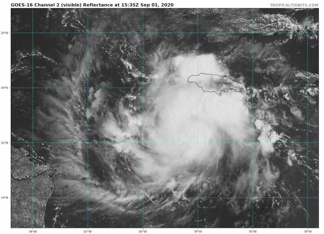
gatorcane wrote:Saved loop showing the nice outflow and banding. Not surprising this developed. Models don’t do well with micro storms:

https://i.postimg.cc/x8vmxqd5/goes16-vis-16-L-202009011535.gif


Such a pretty thing. :) But it seems like a lot of the sat loops I've seen lately have been jumping around. Is something going on with them?
0 likes   


Return to “2020”

Who is online

Users browsing this forum: No registered users and 28 guests