NDG wrote:12z GFS says hello Fall goodbye peak of the hurricane season.
https://i.imgur.com/WVbTNDj.png
I thought the gfs was out to lunch with this trof?
Moderator: S2k Moderators

NDG wrote:12z GFS says hello Fall goodbye peak of the hurricane season.
https://i.imgur.com/WVbTNDj.png
NDG wrote:12z GFS says hello Fall goodbye peak of the hurricane season.
https://i.imgur.com/WVbTNDj.png


SFLcane wrote:NDG wrote:12z GFS says hello Fall goodbye peak of the hurricane season.
https://i.imgur.com/WVbTNDj.png
I thought the gfs was out to lunch with this trof?It’s ok we can watch the peak of the season from a distance as this will no doupt weaken whatever little ridging there is and recurve any aew”s. GOM based on this run will be highly unfavorable for a while

AutoPenalti wrote:
I can bet my house this strong of a trough ain’t happening.
crownweather wrote:Check out what's going on in the Western Pacific. The 2 typhoons aren't curving as quickly to the north and northeast as was progged by guidance just a couple of days ago.
This potentially tells me that the Central and Eastern US trough may not be as deep as the GFS model says. I think the WAR may hold off any troughs and lead to some "adjustments" westward with any tropical systems moving from the eastern Atlantic.


NDG wrote:crownweather wrote:Check out what's going on in the Western Pacific. The 2 typhoons aren't curving as quickly to the north and northeast as was progged by guidance just a couple of days ago.
This potentially tells me that the Central and Eastern US trough may not be as deep as the GFS model says. I think the WAR may hold off any troughs and lead to some "adjustments" westward with any tropical systems moving from the eastern Atlantic.
I've been meaning to ask that question, those Typhoons seem be very far west to affect the patter, doesn't usually happens when they are closer to Japan and track NE north of them?

AutoPenalti wrote:SFLcane wrote:NDG wrote:12z GFS says hello Fall goodbye peak of the hurricane season.
https://i.imgur.com/WVbTNDj.png
I thought the gfs was out to lunch with this trof?It’s ok we can watch the peak of the season from a distance as this will no doupt weaken whatever little ridging there is and recurve any aew”s. GOM based on this run will be highly unfavorable for a while
I can bet my house this strong of a trough ain’t happening.


crownweather wrote:NDG wrote:crownweather wrote:Check out what's going on in the Western Pacific. The 2 typhoons aren't curving as quickly to the north and northeast as was progged by guidance just a couple of days ago.
This potentially tells me that the Central and Eastern US trough may not be as deep as the GFS model says. I think the WAR may hold off any troughs and lead to some "adjustments" westward with any tropical systems moving from the eastern Atlantic.
I've been meaning to ask that question, those Typhoons seem be very far west to affect the patter, doesn't usually happens when they are closer to Japan and track NE north of them?
Yeah, when a typhoon passes just east of Japan, you can bet the farm that you're going to see a trough build in the Eastern US in about 8-14 days and curve anything out. Since we're seeing these two typhoons head for Korea or perhaps southern Japan, it could potentially mean that areas from the E Gulf Coast to the FL/GA/Carolina coast could be at risk from a direct impact in 8-14 days.

SFLcane wrote:It does seem to maybe be overdoing the trof. we’ll see.


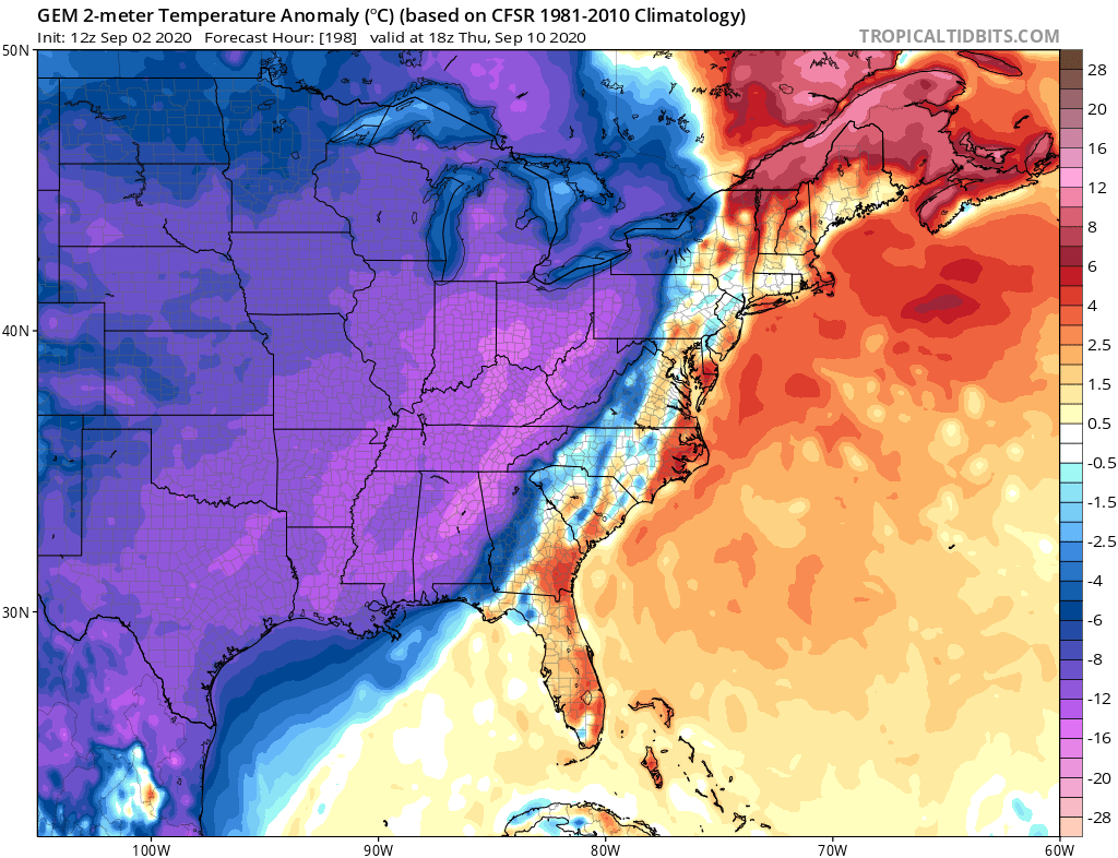
gatorcane wrote::uarrow: The GFS has support from the CMC on this:
https://i.postimg.cc/qMHbF9QZ/gem-T2ma-eus-34.png


Users browsing this forum: StPeteMike, WaveBreaking and 267 guests