2020 Global Model Runs Discussion (Out thru day 16)

This is the general tropical discussion area. Anyone can take their shot at predicting a storms path.

Moderator: S2k Moderators

Forum rules

The posts in this forum are NOT official forecasts and should not be used as such. They are just the opinion of the poster and may or may not be backed by sound meteorological data. They are NOT endorsed by any professional institution or STORM2K. For official information, please refer to products from the National Hurricane Center and National Weather Service.

Help Support Storm2K
Message
Author
User avatar
SFLcane
S2K Supporter
S2K Supporter
Posts: 10163
Age: 47
Joined: Sat Jun 05, 2010 1:44 pm
Location: Lake Worth Florida

Re: 2020 Global Model Runs Discussion (Out thru day 16)

#1861 Postby SFLcane » Wed Sep 02, 2020 11:50 am

NDG wrote:12z GFS says hello Fall goodbye peak of the hurricane season. :lol:

https://i.imgur.com/WVbTNDj.png


I thought the gfs was out to lunch with this trof? :ggreen: It’s ok we can watch the peak of the season from a distance as this will no doupt weaken whatever little ridging there is and recurve any aew”s. GOM based on this run will be highly unfavorable for a while
0 likes   

TheStormExpert

Re: 2020 Global Model Runs Discussion (Out thru day 16)

#1862 Postby TheStormExpert » Wed Sep 02, 2020 11:50 am

NDG wrote:12z GFS says hello Fall goodbye peak of the hurricane season. :lol:

https://i.imgur.com/WVbTNDj.png

It'd be nice if we see fronts like this during the winter months. :lol:
2 likes   

User avatar
weeniepatrol
Category 5
Category 5
Posts: 1276
Joined: Sat Aug 22, 2020 5:30 pm
Location: WA State

Re: 2020 Global Model Runs Discussion (Out thru day 16)

#1863 Postby weeniepatrol » Wed Sep 02, 2020 11:54 am

Lol, it's already been proven again and again and again that the GFS is utterly clueless this season. I will take the opposite of what it shows because that will verify better.
1 likes   

User avatar
crownweather
S2K Supporter
S2K Supporter
Posts: 595
Age: 50
Joined: Sat Aug 12, 2006 9:21 am
Location: Sturbridge, Massachusetts
Contact:

Re: 2020 Global Model Runs Discussion (Out thru day 16)

#1864 Postby crownweather » Wed Sep 02, 2020 11:56 am

Check out what's going on in the Western Pacific. The 2 typhoons aren't curving as quickly to the north and northeast as was progged by guidance just a couple of days ago.

This potentially tells me that the Central and Eastern US trough may not be as deep as the GFS model says. I think the WAR may hold off any troughs and lead to some "adjustments" westward with any tropical systems moving from the eastern Atlantic.
7 likes   
Rob Lightbown
Crown Weather Services
https://crownweather.com

AutoPenalti
Category 5
Category 5
Posts: 4030
Age: 29
Joined: Mon Aug 17, 2015 4:16 pm
Location: Ft. Lauderdale, Florida

Re: 2020 Global Model Runs Discussion (Out thru day 16)

#1865 Postby AutoPenalti » Wed Sep 02, 2020 12:02 pm

SFLcane wrote:
NDG wrote:12z GFS says hello Fall goodbye peak of the hurricane season. :lol:

https://i.imgur.com/WVbTNDj.png


I thought the gfs was out to lunch with this trof? :ggreen: It’s ok we can watch the peak of the season from a distance as this will no doupt weaken whatever little ridging there is and recurve any aew”s. GOM based on this run will be highly unfavorable for a while

I can bet my house this strong of a trough ain’t happening.
8 likes   
The posts in this forum are NOT official forecasts and should not be used as such. They are just the opinion of the poster and may or may not be backed by sound meteorological data. They are NOT endorsed by any professional institution or STORM2K. For official information, please refer to products from the NHC and NWS.


Model Runs Cheat Sheet:
GFS (5:30 AM/PM, 11:30 AM/PM)
HWRF, GFDL, UKMET, NAVGEM (6:30-8:00 AM/PM, 12:30-2:00 AM/PM)
ECMWF (1:45 AM/PM)

TCVN
is a weighted averaged

User avatar
toad strangler
S2K Supporter
S2K Supporter
Posts: 4543
Joined: Sun Jul 28, 2013 3:09 pm
Location: Earth
Contact:

Re: 2020 Global Model Runs Discussion (Out thru day 16)

#1866 Postby toad strangler » Wed Sep 02, 2020 12:07 pm

AutoPenalti wrote:
I can bet my house this strong of a trough ain’t happening.


and I'll throw my camper in.
2 likes   

User avatar
NDG
S2K Supporter
S2K Supporter
Posts: 15446
Joined: Sun Jul 09, 2006 10:14 pm
Location: Orlando, FL

Re: 2020 Global Model Runs Discussion (Out thru day 16)

#1867 Postby NDG » Wed Sep 02, 2020 12:07 pm

crownweather wrote:Check out what's going on in the Western Pacific. The 2 typhoons aren't curving as quickly to the north and northeast as was progged by guidance just a couple of days ago.

This potentially tells me that the Central and Eastern US trough may not be as deep as the GFS model says. I think the WAR may hold off any troughs and lead to some "adjustments" westward with any tropical systems moving from the eastern Atlantic.


I've been meaning to ask that question, those Typhoons seem be very far west to affect the patter, doesn't usually happens when they are closer to Japan and track NE north of them?
0 likes   

User avatar
SFLcane
S2K Supporter
S2K Supporter
Posts: 10163
Age: 47
Joined: Sat Jun 05, 2010 1:44 pm
Location: Lake Worth Florida

Re: 2020 Global Model Runs Discussion (Out thru day 16)

#1868 Postby SFLcane » Wed Sep 02, 2020 12:10 pm

Regarding the GFS Part of that is probably the Pacific bias... There does seem like there will be PV under the ridge that will probably cause some shear and also keep the storms from plowing west.
0 likes   

User avatar
crownweather
S2K Supporter
S2K Supporter
Posts: 595
Age: 50
Joined: Sat Aug 12, 2006 9:21 am
Location: Sturbridge, Massachusetts
Contact:

Re: 2020 Global Model Runs Discussion (Out thru day 16)

#1869 Postby crownweather » Wed Sep 02, 2020 12:10 pm

NDG wrote:
crownweather wrote:Check out what's going on in the Western Pacific. The 2 typhoons aren't curving as quickly to the north and northeast as was progged by guidance just a couple of days ago.

This potentially tells me that the Central and Eastern US trough may not be as deep as the GFS model says. I think the WAR may hold off any troughs and lead to some "adjustments" westward with any tropical systems moving from the eastern Atlantic.


I've been meaning to ask that question, those Typhoons seem be very far west to affect the patter, doesn't usually happens when they are closer to Japan and track NE north of them?


Yeah, when a typhoon passes just east of Japan, you can bet the farm that you're going to see a trough build in the Eastern US in about 8-14 days and curve anything out. Since we're seeing these two typhoons head for Korea or perhaps southern Japan, it could potentially mean that areas from the E Gulf Coast to the FL/GA/Carolina coast could be at risk from a direct impact in 8-14 days.
1 likes   
Rob Lightbown
Crown Weather Services
https://crownweather.com

User avatar
SFLcane
S2K Supporter
S2K Supporter
Posts: 10163
Age: 47
Joined: Sat Jun 05, 2010 1:44 pm
Location: Lake Worth Florida

Re: 2020 Global Model Runs Discussion (Out thru day 16)

#1870 Postby SFLcane » Wed Sep 02, 2020 12:11 pm

AutoPenalti wrote:
SFLcane wrote:
NDG wrote:12z GFS says hello Fall goodbye peak of the hurricane season. :lol:

https://i.imgur.com/WVbTNDj.png


I thought the gfs was out to lunch with this trof? :ggreen: It’s ok we can watch the peak of the season from a distance as this will no doupt weaken whatever little ridging there is and recurve any aew”s. GOM based on this run will be highly unfavorable for a while

I can bet my house this strong of a trough ain’t happening.


Hope you guys don’t loose your homes. :lol:
0 likes   

User avatar
SFLcane
S2K Supporter
S2K Supporter
Posts: 10163
Age: 47
Joined: Sat Jun 05, 2010 1:44 pm
Location: Lake Worth Florida

Re: 2020 Global Model Runs Discussion (Out thru day 16)

#1871 Postby SFLcane » Wed Sep 02, 2020 12:15 pm

It does seem to maybe be overdoing the trof. we’ll see.
0 likes   

User avatar
DestinHurricane
Category 4
Category 4
Posts: 935
Joined: Tue May 01, 2018 8:05 am
Location: New York, NY

Re: 2020 Global Model Runs Discussion (Out thru day 16)

#1872 Postby DestinHurricane » Wed Sep 02, 2020 12:17 pm

crownweather wrote:
NDG wrote:
crownweather wrote:Check out what's going on in the Western Pacific. The 2 typhoons aren't curving as quickly to the north and northeast as was progged by guidance just a couple of days ago.

This potentially tells me that the Central and Eastern US trough may not be as deep as the GFS model says. I think the WAR may hold off any troughs and lead to some "adjustments" westward with any tropical systems moving from the eastern Atlantic.


I've been meaning to ask that question, those Typhoons seem be very far west to affect the patter, doesn't usually happens when they are closer to Japan and track NE north of them?


Yeah, when a typhoon passes just east of Japan, you can bet the farm that you're going to see a trough build in the Eastern US in about 8-14 days and curve anything out. Since we're seeing these two typhoons head for Korea or perhaps southern Japan, it could potentially mean that areas from the E Gulf Coast to the FL/GA/Carolina coast could be at risk from a direct impact in 8-14 days.


That's interesting. I had no idea that typhoons in the wpac influenced the Atlantic. What happens if the Typhoons shift even further west and into the yellow sea or right on the west coast of the Korean peninsula?
0 likes   
Michael 2018

AxaltaRacing24
Category 5
Category 5
Posts: 1753
Age: 25
Joined: Wed Jul 27, 2016 11:14 am
Location: Jupiter, FL

Re: 2020 Global Model Runs Discussion (Out thru day 16)

#1873 Postby AxaltaRacing24 » Wed Sep 02, 2020 12:24 pm

SFLcane wrote:It does seem to maybe be overdoing the trof. we’ll see.

personally, i see 0 reason why that trough verifies. this same stuff happens in winter with the gfs.
0 likes   

User avatar
gatorcane
S2K Supporter
S2K Supporter
Posts: 23691
Age: 47
Joined: Sun Mar 13, 2005 3:54 pm
Location: Boca Raton, FL

Re: 2020 Global Model Runs Discussion (Out thru day 16)

#1874 Postby gatorcane » Wed Sep 02, 2020 12:30 pm

:uarrow: The GFS has support from the CMC on this:

Image
0 likes   

AxaltaRacing24
Category 5
Category 5
Posts: 1753
Age: 25
Joined: Wed Jul 27, 2016 11:14 am
Location: Jupiter, FL

Re: 2020 Global Model Runs Discussion (Out thru day 16)

#1875 Postby AxaltaRacing24 » Wed Sep 02, 2020 12:48 pm

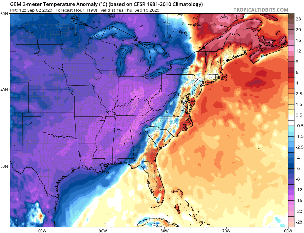
gatorcane wrote::uarrow: The GFS has support from the CMC on this:

https://i.postimg.cc/qMHbF9QZ/gem-T2ma-eus-34.png

and that changes exactly nothing for me. it's still not going to be that strong in my opinion. especially based on current trends.
1 likes   

User avatar
SFLcane
S2K Supporter
S2K Supporter
Posts: 10163
Age: 47
Joined: Sat Jun 05, 2010 1:44 pm
Location: Lake Worth Florida

Re: 2020 Global Model Runs Discussion (Out thru day 16)

#1876 Postby SFLcane » Wed Sep 02, 2020 12:49 pm

Might wanna head over to the thread for the wave exiting Africa. GEFS just got real interesting!
0 likes   

mlfreeman
S2K Supporter
S2K Supporter
Posts: 81
Joined: Sun Feb 18, 2018 11:48 am
Location: Jacksonville, FL

Re: 2020 Global Model Runs Discussion (Out thru day 16)

#1877 Postby mlfreeman » Wed Sep 02, 2020 12:50 pm

Image

On the one hand, 384 hours on the GFS 12z today.
On the other hand, 2020.
0 likes   

USTropics
Professional-Met
Professional-Met
Posts: 2659
Joined: Sun Aug 12, 2007 3:45 am
Location: Florida State University

Re: 2020 Global Model Runs Discussion (Out thru day 16)

#1878 Postby USTropics » Wed Sep 02, 2020 1:14 pm

Always love the WPAC teleconnections and how they impact large scale steering patterns over NA. Models show varying solutions, and I'll do my best to break down what exactly is occurring. First, here is a 48 hour forecast by the ECMWF showing our two typhoons in the WPAC. I've included some shrewd outlines of their eventual track (purple track is Maysak, blue track is Haishen).

Image

Now let's move out 48 hours in time (96 hour forecast), and we'll see Maysak has a weak signature here on the 500mb chart as it becomes extra tropical and begins to interact with the North Pacific jet stream. Essentially what we'll see is an amplification of the high pressure to the NE (labeled H1), which will then amplify the cutoff low towards the east (labeled L1). Haishen is also seen here as a potent Typhoon on the same trajectory as Maysak:

Image

Now let's move out 3 more days (144 hour forecast). We've had this trickle down effect, where H1 became pumped up, amplified L1, which is now creating a sort of Omega block pattern with the high pressure off the NW coast of the United States (labeled H2). We also have our longwave trough over the United states (labeled L2). In addition, we have Haishen repeating the process (circled in green) and this disturbance in the EPAC (circled in pink) that is just enough of a signature to prevent H2 from expanding much to the south:

Image

End result (168 hour forecast on the 00z ECMWF), a cutoff low forms (L2, green arrows show it cutting off) on the backend of the longwave trough, and a lot of this can be contributed to the presence of another high pressure area to the east (labeled H3). This is where model solutions really begin to vary, as the GFS has the entire longwave trough negatively tilting and rotating all the way down to the GOM before finally lifting out to the NE. Meanwhile, as you can see the ECMWF instead has a cutoff low that forms, and the longwave trough passes over the top of the high pressure area (H3):

Image

As Crownweather stated, and in my personal experience, a cutoff low forming and diving towards the SW United States seems more realistic (we typically see a more chaotic weather pattern over NA and the EC when these typhoons recurve towards the east of Japan). Again this is a 7+ day forecast by all the models, so a lot will change before we end up with an actual solution.
10 likes   

User avatar
NDG
S2K Supporter
S2K Supporter
Posts: 15446
Joined: Sun Jul 09, 2006 10:14 pm
Location: Orlando, FL

Re: 2020 Global Model Runs Discussion (Out thru day 16)

#1879 Postby NDG » Wed Sep 02, 2020 1:30 pm

12z Euro so far is coming in similar to last night's run, with the trough negatively tilted towards the Rockies into the 4 corners area. Is standing its ground against the GFS.

BTW, 12z GEFS is much closer to the 0z EPS ensembles than to the 12z GFS Operational run.


Image
Image
2 likes   

User avatar
TheProfessor
Professional-Met
Professional-Met
Posts: 3506
Age: 28
Joined: Tue Dec 03, 2013 10:56 am
Location: Wichita, Kansas

Re: 2020 Global Model Runs Discussion (Out thru day 16)

#1880 Postby TheProfessor » Wed Sep 02, 2020 1:41 pm

As always I would advise using the ensemble forecasts instead of day to day deterministic runs. Knowing biases as well will also help deciphering models. Anyways I think we're going to continue to see storms struggle in the MDR if that mid-level low forms. That low will also keep storms from recurving if they don't take an early exit when they leave Africa, which is an additional concern. As for biases we know that the GFS tends to overdue troughs and is usually the more progressive models. Meanwhile the Euro tends to overdue ridges and will sometimes favor blocking a bit too much. In all likelihood we'll see something in between, which suggests possible Florida EC and U.S EC threats when storms are approaching from the east. Storms in the Caribbean would be pulled into the Gulf like Charley, Ivan, Marco, etc. However, since this pattern is dependent on two tropical cyclones, we'll need to wait and see what they do, the further wester they recurve, the further west we'll likely see the trough setup and the more likely we'll see a cutoff low develop, which would open the whole GoM up for waves coming off of Africa.

To put it plainly I don't like the look of this pattern with combination of the wave train that the models are starting to show. As stated above, any storm that doesn't take an early exit to the north, assuming that mid-level trough does form in the Atlantic, will likely be stored towards the U.S without an exit route until the storm either gets too close to comfort, or landfalls. Then there's both the GEFS and GEPS showing a large upper level anticyclone developing off the African coast for waves to travel right into to help keep them organized. Depending on how much wind shear we see, we could have a case where waves have well developed MLCs, but LLCs struggle due to shear until the storms get further west where they can then go off under better conditions.
4 likes   
An alumnus of The Ohio State University.

Your local National Weather Service office is your best source for weather information.


Return to “Talkin' Tropics”

Who is online

Users browsing this forum: Blown Away, dl20415, Google [Bot], Javlin, Kennethb and 29 guests