Tropical Wave has emerged from West Africa (Is Invest 95L)
Moderator: S2k Moderators
Forum rules

The posts in this forum are NOT official forecasts and should not be used as such. They are just the opinion of the poster and may or may not be backed by sound meteorological data. They are NOT endorsed by any professional institution or STORM2K. For official information, please refer to products from the National Hurricane Center and National Weather Service.
-
SFLcane

- S2K Supporter

- Posts: 10281
- Age: 48
- Joined: Sat Jun 05, 2010 1:44 pm
- Location: Lake Worth Florida
Re: Tropical Wave inside Africa
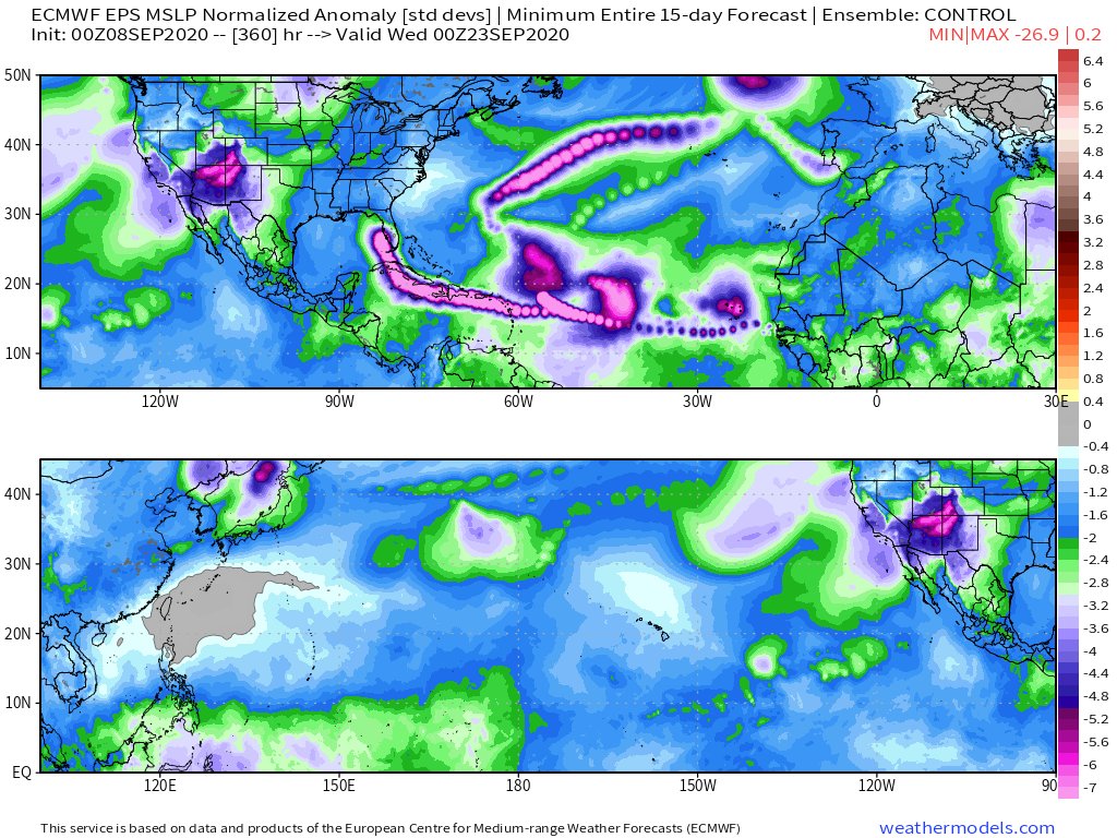
EPS control run with shades of Irma with a potential break in the ridge over FL. Long ways out
2 likes

Re: Tropical Wave inside Africa
No doubt that general climo heavily favors recurves OTS or in some cases open sea dissipations of far E geneses. That looks highly likely for Paulette and Rene (although Rene is affecting CV, itself). However, for this wave over W Africa, fighting that scenario is an expected pretty rapid mainly W move at a pretty low latitude for at least several days. Most don’t move bodily westward like that. Although many still do, the ones that do don’t miss the Caribbean and other W ATL basin land areas in as high a percentage. Let’s see if the modeling is right and it does actually move pretty fast and only a little N of W. Also, let’s see if this comes off down near 11N as opposed to, say, 13-14N.
Also fighting climo is that this is during La Niña. CV storms during La Niña have hit W basin land areas at a higher rate than during other ENSO due to a lower percentage of OTS recurves and open sea dissipations. In addition, the projected genesis date of ~9/10-11 is still at the tail end of the highest risk genesis period for W ATL landfalls, which is ~8/15-9/11. Only after this does the risk start to fall though it does start falling fairly rapidly.
So, if this really turns out to be a low latitude mainly W moving pretty fast moving CV storm emerging Africa still within the tail end of the highest risk period of 8/15-9/11, La Niña climo does not say that Paulette, Rene, and this one will all 3 very likely miss the W ATL land areas. Climo probably says it is a lot closer to, say, 50-50 that all 3 will not miss the considering all of the above for this W African wave.
Climo doesn’t say that each and every CV storm will either recurve OTS or in some cases dissipate out in the open water. It says that most will. Well, assuming that Paulette and Rene will recurve safely and/or dissipate out in the ocean, this African wave landfalling in the W basin would still be only 33% of these 3. A 33% landfall rate during the heart of the CV season in La Niña is not really “going against”
climo.
4 likes
Personal Forecast Disclaimer:
The posts in this forum are NOT official forecasts and should not be used as such. They are just the opinion of the poster and may or may not be backed by sound meteorological data. They are NOT endorsed by any professional institution or storm2k.org. For official information, please refer to the NHC and NWS products.
The posts in this forum are NOT official forecasts and should not be used as such. They are just the opinion of the poster and may or may not be backed by sound meteorological data. They are NOT endorsed by any professional institution or storm2k.org. For official information, please refer to the NHC and NWS products.
-
Spacecoast

- Category 2

- Posts: 773
- Joined: Thu Aug 31, 2017 2:03 pm
Re: Tropical Wave inside Africa
Another factor is intensity.
Comparing GFS-Para to ECMWF Operational...
GFS-Para crosses 50W on 12z Wednesday, with a pressure of 950, recurving earlier
ECMWF crossess 50W on 00z Tuesday, with a pressure of only 1005
Looking at the ECEN, also illustrates this relationship.
1 likes
Re: Tropical Wave inside Africa
Spacecoast wrote::uarrow:
Another factor is intensity.
Comparing GFS-Para to ECMWF Operational...
GFS-Para crosses 50W on 12z Wednesday, with a pressure of 950, recurving earlier
ECMWF crossess 50W on 00z Tuesday, with a pressure of only 1005
Looking at the ECEN, also illustrates this relationship.
Isn’t the ECMWF also sorta high-biased with pre-developed or developing systems?
0 likes
-
Hurricaneman

- Category 5

- Posts: 7404
- Age: 45
- Joined: Tue Aug 31, 2004 3:24 pm
- Location: central florida
Re: Tropical Wave inside Africa
The 12zGFS shows this heading to the southern Lesser Antilles, way SW of the 6z run
0 likes
-
toad strangler

- S2K Supporter
- Posts: 4546
- Joined: Sun Jul 28, 2013 3:09 pm
- Location: Earth
- Contact:
Re: Tropical Wave inside Africa
Hurricaneman wrote:The 12zGFS shows this heading to the southern Lesser Antilles, way SW of the 6z run
Energy splits into two after splashdown with one half doing a Texas Two Step with Rene. Bizarre.
0 likes
My Weather Station
https://www.wunderground.com/dashboard/pws/KFLPORTS603
https://www.wunderground.com/dashboard/pws/KFLPORTS603
-
TheStormExpert
-
Hurricaneman
- Category 5
- Posts: 7404
- Age: 45
- Joined: Tue Aug 31, 2004 3:24 pm
- Location: central florida
Re: Tropical Wave inside Africa
toad strangler wrote:Hurricaneman wrote:The 12zGFS shows this heading to the southern Lesser Antilles, way SW of the 6z run
Energy splits into two after splashdown with one half doing a Texas Two Step with Rene. Bizarre.
Yep, missed that, may be a case where the model doesn’t know what to do with it. Makes little sense seeing as it has a good circulation. Based on that the Euro May have the better solution as far as the evolution
0 likes
-
SFLcane
- S2K Supporter
- Posts: 10281
- Age: 48
- Joined: Sat Jun 05, 2010 1:44 pm
- Location: Lake Worth Florida
Re: Tropical Wave inside Africa
Gfs lol.. 
West part breaks off and goes in the Southern Caribbean.
West part breaks off and goes in the Southern Caribbean.
0 likes

Re: Tropical Wave inside Africa
SFLcane wrote:Gfs lol..
West part breaks off and goes in the Southern Caribbean.
A Caribbean Cruiser hurricane and a Fujiwhara with Rene. Tons of fun (translation: headaches).
1 likes
Irene '11 Sandy '12 Hermine '16 5/15/2018 Derecho Fay '20 Isaias '20 Elsa '21 Henri '21 Ida '21
I am only a meteorology enthusiast who knows a decent amount about tropical cyclones. Look to the professional mets, the NHC, or your local weather office for the best information.
I am only a meteorology enthusiast who knows a decent amount about tropical cyclones. Look to the professional mets, the NHC, or your local weather office for the best information.
-
SFLcane
- S2K Supporter
- Posts: 10281
- Age: 48
- Joined: Sat Jun 05, 2010 1:44 pm
- Location: Lake Worth Florida
Re: Tropical Wave inside Africa
aspen wrote:SFLcane wrote:Gfs lol..
West part breaks off and goes in the Southern Caribbean.
A Caribbean Cruiser hurricane and a Fujiwhara with Rene. Tons of fun (translation: headaches).
Very Bizarre solution.
0 likes
-
toad strangler
- S2K Supporter
- Posts: 4546
- Joined: Sun Jul 28, 2013 3:09 pm
- Location: Earth
- Contact:
Re: Tropical Wave inside Africa
GFS is stuck. I think they pulled the plug on it 
0 likes
My Weather Station
https://www.wunderground.com/dashboard/pws/KFLPORTS603
https://www.wunderground.com/dashboard/pws/KFLPORTS603
-
chris_fit

- Category 5
- Posts: 3261
- Age: 43
- Joined: Wed Sep 10, 2003 11:58 pm
- Location: Tampa Bay Area, FL
Re: Tropical Wave inside Africa
toad strangler wrote:GFS is stuck. I think they pulled the plug on it
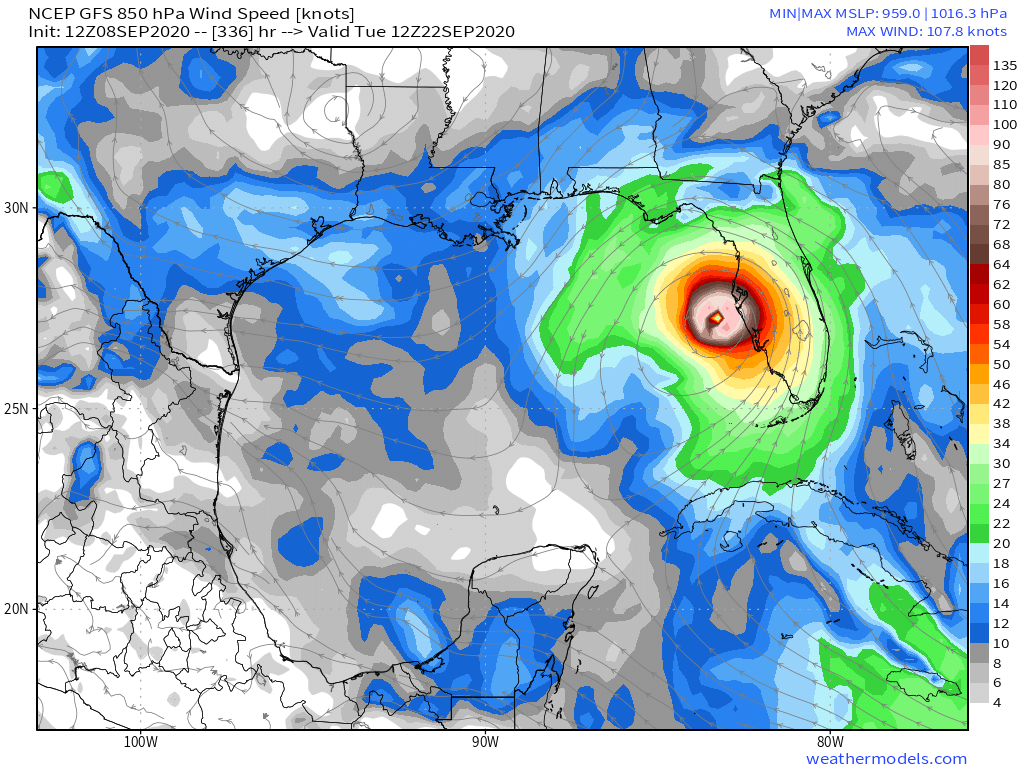
I think it's tropical tidbits - using a paid site the run is finished.... Hurricane into Tampa Bay Area
1 likes
-
TheStormExpert
Re: Tropical Wave inside Africa
mcheer23 wrote:GFS ends up near tampa.
For some odd reason the 12z GFS hasn't finished running past 10 days (240hrs.).
0 likes
-
mcheer23

- Professional-Met

- Posts: 441
- Age: 32
- Joined: Sun Jun 24, 2012 8:24 pm
- Location: Sugar Land, Texas
Re: Tropical Wave inside Africa
TheStormExpert wrote:mcheer23 wrote:GFS ends up near tampa.
For some odd reason the 12z GFS hasn't finished running past 10 days (240hrs.).
GFS crashed on Tropical Tidbits.
0 likes

Re: Tropical Wave inside Africa
toad strangler wrote:Hurricaneman wrote:The 12zGFS shows this heading to the southern Lesser Antilles, way SW of the 6z run
Energy splits into two after splashdown with one half doing a Texas Two Step with Rene. Bizarre.
tropicaltidbits conked out at hr 228, but it looks like the remnants of Rene and Paulette are both still in the central Atlantic when future Sandy/Teddy enters the picture.
0 likes
-
Hypercane_Kyle

- Category 5
- Posts: 3465
- Joined: Sat Mar 07, 2015 7:58 pm
- Location: Cape Canaveral, FL
Re: Tropical Wave inside Africa
FWIW, I don't think the system on the 12z GFS is the same one we're tracking over Africa. Looks like the GFS randomly splits off a LLC from the wave (which remains weak throughout the run) and develops that instead. Seems unlikely to me.
0 likes
My posts are my own personal opinion, defer to the National Hurricane Center (NHC) and other NOAA products for decision making during hurricane season.
Who is online
Users browsing this forum: No registered users and 394 guests