Disturbance over The Bahamas (Is Invest 96L)
Moderator: S2k Moderators
Forum rules

The posts in this forum are NOT official forecasts and should not be used as such. They are just the opinion of the poster and may or may not be backed by sound meteorological data. They are NOT endorsed by any professional institution or STORM2K. For official information, please refer to products from the National Hurricane Center and National Weather Service.
-
Dean4Storms
- S2K Supporter

- Posts: 6358
- Age: 63
- Joined: Sun Aug 31, 2003 1:01 pm
- Location: Miramar Bch. FL
Re: Disturbance east of Bahamas
Definite consolidation and increasing vorticity with this disturbance. At least the SST's in the Gulf aren't way above normal, about 1C after Laura churned it up but still plenty warm enough for a hurricane.
0 likes

Re: Disturbance east of Bahamas
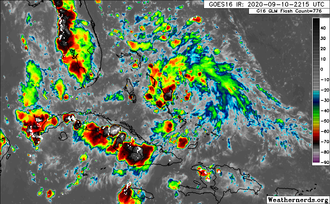
Last visible loop of the day, you can tell there's plenty of UL divergence and surface convergence getting going on when convection keeps firing up this time of the evening.
This should be tagged as an invest if not later tonight, tomorrow morning. IMO.
H85 vorticity is finally showing up.
I was just thinking that the reason why the models may not be doing much with this system when it gets into the GOM because of the disturbance ahead of it and may be struggling with their interaction if any. If you look at the two models that are not developing it, ICON and CMC they both show the disturbance ahead of it stronger (circulation wise) and this system start rotating around it, but I don't believe this will happen. This system certainly will have the upper hand with better moisture envelop and better UL winds, will be the dominant feature in the GOM.
Something similar happened with Marco and Laura, for a while global models were showing Laura to be fairly weak in the GOM. I can't wait to see what the HWRF will do when they start running tropical models on this.
5 likes
Re: Disturbance east of Bahamas
Dean4Storms wrote:Definite consolidation and increasing vorticity with this disturbance. At least the SST's in the Gulf aren't way above normal, about 1C after Laura churned it up but still plenty warm enough for a hurricane.
Mid to upper 80s in the GOM are more than warm enough and above average for this time of the year.
0 likes
-
gatorcane

- S2K Supporter
- Posts: 23708
- Age: 48
- Joined: Sun Mar 13, 2005 3:54 pm
- Location: Boca Raton, FL
Re: Disturbance east of Bahamas
Up to 50%
A large area of disorganized showers and thunderstorms extending
from near the Central and Northwest Bahamas eastward over the
western Atlantic for a few hundred miles is associated with a
surface trough of low pressure. This system is forecast to
move westward, crossing the Bahamas and Florida on Friday and moving
into the eastern Gulf of Mexico over the weekend. Upper-level
winds are expected to become conducive for development, and a
tropical depression could form while this system moves slowly
west-northwestward over the eastern Gulf of Mexico early next week.
Regardless of development, this system is expected to produce
locally heavy rainfall over portions of South Florida and the Keys
during the next couple of days.
* Formation chance through 48 hours...low...10 percent.
* Formation chance through 5 days...medium...50 percent.
1 likes
-
jasons2k

- Storm2k Executive

- Posts: 8290
- Age: 52
- Joined: Wed Jul 06, 2005 12:32 pm
- Location: The Woodlands, TX
Re: Disturbance east of Bahamas
I'm becoming concerned about this system. I hope it gets designated soon and they start running the tropical models on it.
3 likes
-
Aric Dunn
- Category 5

- Posts: 21238
- Age: 43
- Joined: Sun Sep 19, 2004 9:58 pm
- Location: Ready for the Chase.
- Contact:
Re: Disturbance east of Bahamas
There is a slightly more concentrated area of convection now. could be the start of something.
1 likes
Note: If I make a post that is brief. Please refer back to previous posts for the analysis or reasoning. I do not re-write/qoute what my initial post said each time.
If there is nothing before... then just ask
Space & Atmospheric Physicist, Embry-Riddle Aeronautical University,
I believe the sky is falling...
If there is nothing before... then just ask
Space & Atmospheric Physicist, Embry-Riddle Aeronautical University,
I believe the sky is falling...

Re: Disturbance east of Bahamas
jasons2k wrote:I'm becoming concerned about this system. I hope it gets designated soon and they start running the tropical models on it.
Yeah...it's looking like it's to going be a North Central to Western GOM issue...
0 likes
-
jlauderdal
- S2K Supporter
- Posts: 7240
- Joined: Wed May 19, 2004 5:46 am
- Location: NE Fort Lauderdale
- Contact:
Re: RE: Re: Disturbance east of Bahamas
It will be tomorrow, i will provide ground observations as it moves through.jasons2k wrote:I'm becoming concerned about this system. I hope it gets designated soon and they start running the tropical models on it.


2 likes
-
Aric Dunn
- Category 5
- Posts: 21238
- Age: 43
- Joined: Sun Sep 19, 2004 9:58 pm
- Location: Ready for the Chase.
- Contact:
Re: Disturbance east of Bahamas
Satellite and radar showing a strong MLC developing with that concentrated area of convection...
if that persists working to the surface wont take too long..
if that persists working to the surface wont take too long..
1 likes
Note: If I make a post that is brief. Please refer back to previous posts for the analysis or reasoning. I do not re-write/qoute what my initial post said each time.
If there is nothing before... then just ask
Space & Atmospheric Physicist, Embry-Riddle Aeronautical University,
I believe the sky is falling...
If there is nothing before... then just ask
Space & Atmospheric Physicist, Embry-Riddle Aeronautical University,
I believe the sky is falling...
-
Socalhurcnegirl227
- Category 1

- Posts: 267
- Age: 37
- Joined: Mon Jun 06, 2016 6:39 pm
- Location: Santa Barbara, CA
Re: Disturbance east of Bahamas
jasons2k wrote:I'm becoming concerned about this system. I hope it gets designated soon and they start running the tropical models on it.
Same. Its giving me some anxiety i have family that just moved to alabama
1 likes
"I'm a wandress, i'm a one night stand,
dont belong to no city, dont belong to no man
i'm the violence in the pouring rain,
I'm a hurricane"
dont belong to no city, dont belong to no man
i'm the violence in the pouring rain,
I'm a hurricane"
Re: Disturbance east of Bahamas
Aric Dunn wrote:Satellite and radar showing a strong MLC developing with that concentrated area of convection...
if that persists working to the surface wont take too long..
Possibly timing well with that new convection and some land interaction to jump start this?
1 likes
-
PTrackerLA

- Category 5
- Posts: 5281
- Age: 42
- Joined: Thu Oct 10, 2002 8:40 pm
- Location: Lafayette, LA
Re: Disturbance east of Bahamas
This is looking very suspicious, gotta admit I've paid more attention to future Sally than this disturbance. Definitely not needed anywhere near Louisiana. Hard to believe it's been 2 weeks since Laura hit. We fared very well but just 70 miles west of here is still basically unliveable. The recovery for SW Louisiana will last for years.
1 likes
-
Aric Dunn
- Category 5
- Posts: 21238
- Age: 43
- Joined: Sun Sep 19, 2004 9:58 pm
- Location: Ready for the Chase.
- Contact:
Re: Disturbance east of Bahamas
if this take 24 to 48 hours to even get to florida it has plenty of time to develop before florida..
environment looks really good.

environment looks really good.
1 likes
Note: If I make a post that is brief. Please refer back to previous posts for the analysis or reasoning. I do not re-write/qoute what my initial post said each time.
If there is nothing before... then just ask
Space & Atmospheric Physicist, Embry-Riddle Aeronautical University,
I believe the sky is falling...
If there is nothing before... then just ask
Space & Atmospheric Physicist, Embry-Riddle Aeronautical University,
I believe the sky is falling...

-
toad strangler

- S2K Supporter
- Posts: 4546
- Joined: Sun Jul 28, 2013 3:09 pm
- Location: Earth
- Contact:
Re: Disturbance east of Bahamas
Aric Dunn wrote:if this take 24 to 48 hours to even get to florida it has plenty of time to develop before florida..
environment looks really good.
https://i.ibb.co/YXvWSxq/Capture.png
Doubt we get a 2005 Katrina redux (FL) but a similar set up
0 likes
My Weather Station
https://www.wunderground.com/dashboard/pws/KFLPORTS603
https://www.wunderground.com/dashboard/pws/KFLPORTS603
Re: Disturbance east of Bahamas
toad strangler wrote:Aric Dunn wrote:if this take 24 to 48 hours to even get to florida it has plenty of time to develop before florida..
environment looks really good.
https://i.ibb.co/YXvWSxq/Capture.png
Doubt we get a 2005 Katrina redux (FL) but a similar set up
Yes a bit similar. Katrina wasn't named until around 77W and still managed to landfall as a hurricane. Slow movers in this region can be troublesome
0 likes
Re: Disturbance east of Bahamas
Aric Dunn wrote:if this take 24 to 48 hours to even get to florida it has plenty of time to develop before florida..
environment looks really good.
https://i.ibb.co/YXvWSxq/Capture.png
Perhaps they want to see if the latest convective burst has staying power ... but I am thinking the time to throw out an invest must be coming soon
2 likes

Re: Disturbance east of Bahamas
Coming together a little further south than they were expecting perhaps, there was some vorticity (looked low level) in the southern Bahamas on the last few visible images where the the heaviest convection is tonight.
0 likes
-
SconnieCane
- Category 5
- Posts: 1013
- Joined: Thu Aug 02, 2018 5:29 pm
- Location: Madison, WI
Re: Disturbance east of Bahamas
I'm curious if anyone can point to the origins of this disturbance. Was it one of those AEWs that kind of fizzled on the way across and everyone kind of stopped paying attention for awhile, or did it arise from something else?
0 likes

Re: Disturbance east of Bahamas
Is there any rule against last minute recon or them changing the recon plane scheduled for the East Gulf feature to head over to this one instead? Because this is looking more serious at the moment...
0 likes
Who is online
Users browsing this forum: No registered users and 131 guests