2020 Global Model Runs Discussion (Out thru day 16)

This is the general tropical discussion area. Anyone can take their shot at predicting a storms path.

Moderator: S2k Moderators

Forum rules

The posts in this forum are NOT official forecasts and should not be used as such. They are just the opinion of the poster and may or may not be backed by sound meteorological data. They are NOT endorsed by any professional institution or STORM2K. For official information, please refer to products from the National Hurricane Center and National Weather Service.

Help Support Storm2K
Message
Author
St0rmTh0r
Category 1
Category 1
Posts: 369
Joined: Tue Jul 14, 2020 8:04 pm

Re: 2020 Global Model Runs Discussion (Out thru day 16)

#2261 Postby St0rmTh0r » Tue Sep 15, 2020 10:22 am

aspen wrote:06z GFS has started to show the Gulf TC that the CMC has been insistent on for the last week. If it, 98L, and 99L all develop, we could hit Beta by next week, and two of those could become hurricanes.

I predicted 15 storms to form in September in the thread it's looking closer to reality than I thought
0 likes   

sma10
Category 5
Category 5
Posts: 1710
Joined: Tue Aug 02, 2005 1:13 pm

Re: 2020 Global Model Runs Discussion (Out thru day 16)

#2262 Postby sma10 » Tue Sep 15, 2020 10:36 am

St0rmTh0r wrote:
aspen wrote:06z GFS has started to show the Gulf TC that the CMC has been insistent on for the last week. If it, 98L, and 99L all develop, we could hit Beta by next week, and two of those could become hurricanes.

I predicted 15 storms to form in September in the thread it's looking closer to reality than I thought


Certainly 10+ is looking like a lock for September, which is amazing in itself.

A bit longer term, towards the end of Sept, there appears to be a hint of a signal coming out of the Central/Western Caribbean on the GEFS/GFS Para. Something to keep an eye on.
0 likes   

St0rmTh0r
Category 1
Category 1
Posts: 369
Joined: Tue Jul 14, 2020 8:04 pm

Re: 2020 Global Model Runs Discussion (Out thru day 16)

#2263 Postby St0rmTh0r » Tue Sep 15, 2020 10:39 am

sma10 wrote:
St0rmTh0r wrote:
aspen wrote:06z GFS has started to show the Gulf TC that the CMC has been insistent on for the last week. If it, 98L, and 99L all develop, we could hit Beta by next week, and two of those could become hurricanes.

I predicted 15 storms to form in September in the thread it's looking closer to reality than I thought


Certainly 10+ is looking like a lock for September, which is amazing in itself.

A bit longer term, towards the end of Sept, there appears to be a hint of a signal coming out of the Central/Western Caribbean on the GEFS/GFS Para. Something to keep an eye on.

Just have that feeling October is going to feature some monsters this year.
0 likes   

User avatar
SFLcane
S2K Supporter
S2K Supporter
Posts: 10163
Age: 47
Joined: Sat Jun 05, 2010 1:44 pm
Location: Lake Worth Florida

Re: 2020 Global Model Runs Discussion (Out thru day 16)

#2264 Postby SFLcane » Tue Sep 15, 2020 11:32 am

Long range para all ready hinting... :eek:

Image
6 likes   

User avatar
ElectricStorm
Category 5
Category 5
Posts: 5057
Age: 24
Joined: Tue Aug 13, 2019 11:23 pm
Location: Skiatook, OK / Norman, OK

Re: 2020 Global Model Runs Discussion (Out thru day 16)

#2265 Postby ElectricStorm » Tue Sep 15, 2020 12:11 pm

SFLcane wrote:Long range para all ready hinting... :eek:

https://i.postimg.cc/hPp0PFB4/A5-F3-FEC5-8773-4742-A574-C2-D5-FE589441.gif

I don't even want to think about what would happen if a well-organized storm gets in when Western Caribbean in October this year
0 likes   
B.S Meteorology, University of Oklahoma '25

Please refer to the NHC, NWS, or SPC for official information.

St0rmTh0r
Category 1
Category 1
Posts: 369
Joined: Tue Jul 14, 2020 8:04 pm

Re: 2020 Global Model Runs Discussion (Out thru day 16)

#2266 Postby St0rmTh0r » Tue Sep 15, 2020 12:20 pm

SFLcane wrote:Long range para all ready hinting... :eek:

https://i.postimg.cc/hPp0PFB4/A5-F3-FEC5-8773-4742-A574-C2-D5-FE589441.gif

That's just the 1st. October could see a record number of storms this year.
0 likes   

BigB0882
S2K Supporter
S2K Supporter
Posts: 2284
Joined: Thu Jul 03, 2003 12:08 am
Location: Baton Rouge, LA
Contact:

Re: 2020 Global Model Runs Discussion (Out thru day 16)

#2267 Postby BigB0882 » Tue Sep 15, 2020 1:08 pm

aspen wrote:06z GFS has started to show the Gulf TC that the CMC has been insistent on for the last week. If it, 98L, and 99L all develop, we could hit Beta by next week, and two of those could become hurricanes.


Where is it showing it in the Gulf and what general direction will it be heading? I know this is all just model watching but I am curious and any images that may have been posted wont load because imgur is blocked at my work. Thanks.
1 likes   

User avatar
toad strangler
S2K Supporter
S2K Supporter
Posts: 4543
Joined: Sun Jul 28, 2013 3:09 pm
Location: Earth
Contact:

Re: 2020 Global Model Runs Discussion (Out thru day 16)

#2268 Postby toad strangler » Tue Sep 15, 2020 1:09 pm

St0rmTh0r wrote:
SFLcane wrote:Long range para all ready hinting... :eek:

https://i.postimg.cc/hPp0PFB4/A5-F3-FEC5-8773-4742-A574-C2-D5-FE589441.gif

That's just the 1st. October could see a record number of storms this year.


Not sure how many storms the Caribbean / Gulf can spit out. It's not like they have a pezz dispenser source for waves like the MDR does.
2 likes   

User avatar
aspen
Category 5
Category 5
Posts: 8819
Joined: Sat Oct 12, 2019 7:10 pm
Location: Connecticut, USA

Re: 2020 Global Model Runs Discussion (Out thru day 16)

#2269 Postby aspen » Tue Sep 15, 2020 1:25 pm
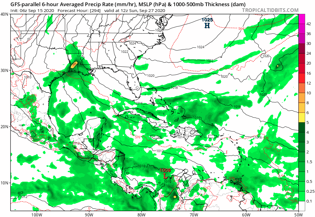
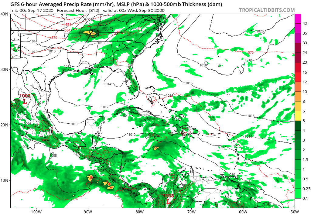
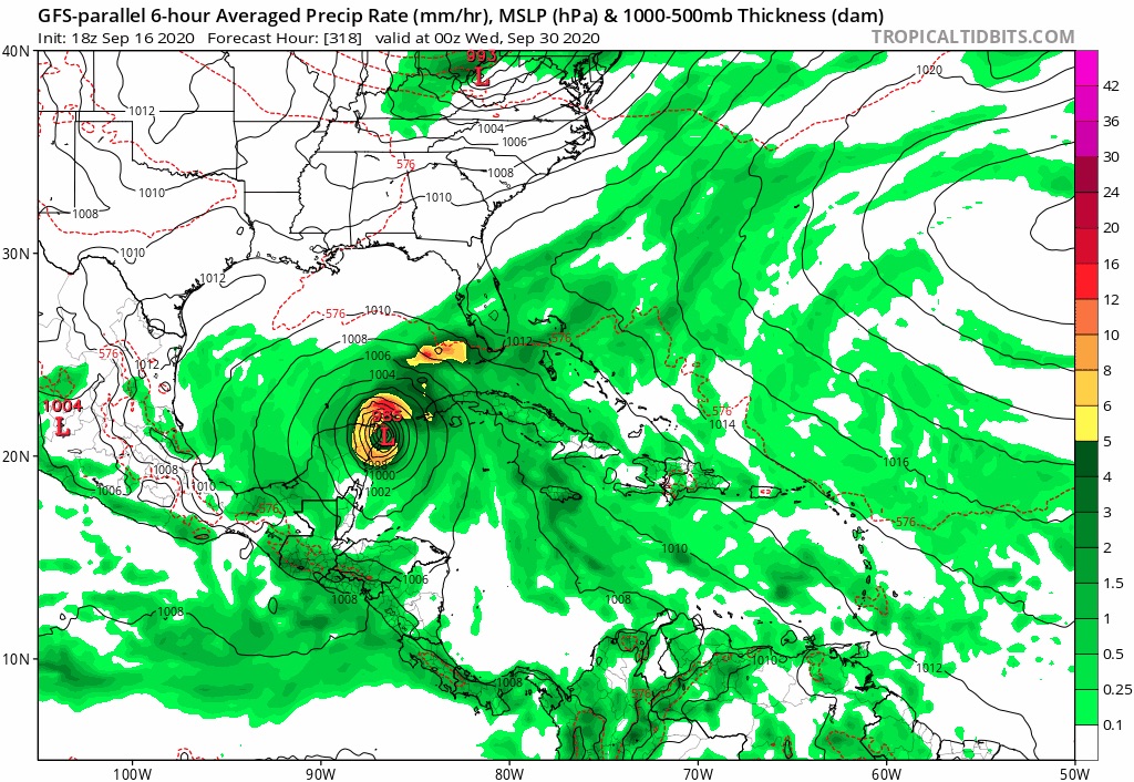
BigB0882 wrote:
aspen wrote:06z GFS has started to show the Gulf TC that the CMC has been insistent on for the last week. If it, 98L, and 99L all develop, we could hit Beta by next week, and two of those could become hurricanes.


Where is it showing it in the Gulf and what general direction will it be heading? I know this is all just model watching but I am curious and any images that may have been posted wont load because imgur is blocked at my work. Thanks.

It’s from the Gulf AOI. It curls into the BoC, develops, and wanders into the central Gulf before turning west and making landfall in Mexico. Development appears to be in about 3 days and landfall could be as much as another 5 days out.
0 likes   
Irene '11 Sandy '12 Hermine '16 5/15/2018 Derecho Fay '20 Isaias '20 Elsa '21 Henri '21 Ida '21

I am only a meteorology enthusiast who knows a decent amount about tropical cyclones. Look to the professional mets, the NHC, or your local weather office for the best information.

User avatar
PTrackerLA
Category 5
Category 5
Posts: 5277
Age: 41
Joined: Thu Oct 10, 2002 8:40 pm
Location: Lafayette, LA

Re: 2020 Global Model Runs Discussion (Out thru day 16)

#2270 Postby PTrackerLA » Tue Sep 15, 2020 2:15 pm

Aye carumba!

3 likes   

User avatar
aspen
Category 5
Category 5
Posts: 8819
Joined: Sat Oct 12, 2019 7:10 pm
Location: Connecticut, USA

Re: 2020 Global Model Runs Discussion (Out thru day 16)

#2271 Postby aspen » Tue Sep 15, 2020 2:16 pm

PTrackerLA wrote:Aye carumba!

https://imgur.com/X17BE6Y

And the Euro is the last to join the party. The GFS, GFS-Para, CMC, ICON, and HWRF have all jumped on board with development of a TC in the western Gulf today, although the Euro has it develop much later.
0 likes   
Irene '11 Sandy '12 Hermine '16 5/15/2018 Derecho Fay '20 Isaias '20 Elsa '21 Henri '21 Ida '21

I am only a meteorology enthusiast who knows a decent amount about tropical cyclones. Look to the professional mets, the NHC, or your local weather office for the best information.

stormlover2013

Re: 2020 Global Model Runs Discussion (Out thru day 16)

#2272 Postby stormlover2013 » Tue Sep 15, 2020 2:21 pm

euro actually develops it good, steering currents weak but euro shifted north .
0 likes   

User avatar
chris_fit
Category 5
Category 5
Posts: 3222
Age: 42
Joined: Wed Sep 10, 2003 11:58 pm
Location: Tampa Bay Area, FL

Re: 2020 Global Model Runs Discussion (Out thru day 16)

#2273 Postby chris_fit » Tue Sep 15, 2020 3:26 pm

stormlover2013 wrote:euro actually develops it good, steering currents weak but euro shifted north .


12Z EPS @ 240 hours.
GoM looks busy.

Image
0 likes   

User avatar
SFLcane
S2K Supporter
S2K Supporter
Posts: 10163
Age: 47
Joined: Sat Jun 05, 2010 1:44 pm
Location: Lake Worth Florida

Re: 2020 Global Model Runs Discussion (Out thru day 16)

#2274 Postby SFLcane » Wed Sep 16, 2020 8:59 am

CFS hinting at Caribbean development.

Image

Image
0 likes   

User avatar
toad strangler
S2K Supporter
S2K Supporter
Posts: 4543
Joined: Sun Jul 28, 2013 3:09 pm
Location: Earth
Contact:

Re: 2020 Global Model Runs Discussion (Out thru day 16)

#2275 Postby toad strangler » Wed Sep 16, 2020 9:04 am

SFLcane wrote:CFS hinting at Caribbean development.


That's 35 days out.
1 likes   

User avatar
blp
Category 5
Category 5
Posts: 2840
Age: 46
Joined: Thu Sep 09, 2004 7:51 pm
Location: Miami, FL
Contact:

Re: 2020 Global Model Runs Discussion (Out thru day 16)

#2276 Postby blp » Wed Sep 16, 2020 9:14 am

toad strangler wrote:
SFLcane wrote:CFS hinting at Caribbean development.


That's 35 days out.


Yes, but I have been watching CFS the last week and it is has been pretty consistent showing October development potential. Considering how favorable this area will be I think this may not be so much fantasy. We will see once the GFS gets inside that range.
2 likes   
The following post is NOT an official forecast and should not be used as such. It is just the opinion of the poster and may or may not be backed by sound meteorological data. It is NOT endorsed by any professional institution including storm2k.org For Official Information please refer to the NHC and NWS products.

User avatar
gfsperpendicular
Category 1
Category 1
Posts: 383
Age: 21
Joined: Mon Jun 19, 2017 3:04 pm
Location: Northern Virginia

Re: 2020 Global Model Runs Discussion (Out thru day 16)

#2277 Postby gfsperpendicular » Wed Sep 16, 2020 9:16 am

toad strangler wrote:That's 35 days out.


When the CFS shows something run-to-run you gotta keep an eye out for it. It showed Isaias well over a month in advance.
0 likes   
I'm not sleeping, I'm waiting for the 0900 UTC advisory!

#1 CMC stan

User avatar
aspen
Category 5
Category 5
Posts: 8819
Joined: Sat Oct 12, 2019 7:10 pm
Location: Connecticut, USA

Re: 2020 Global Model Runs Discussion (Out thru day 16)

#2278 Postby aspen » Wed Sep 16, 2020 9:17 am

blp wrote:
toad strangler wrote:
SFLcane wrote:CFS hinting at Caribbean development.


That's 35 days out.


Yes, but I have been watching CFS the last week and it is has been pretty consistent showing October development potential. Considering how favorable this area will be I think this may not be so much fantasy. We will see once the GFS gets inside that range.

Didn’t the CFS also sniff out Isaias and this ongoing phase of enhanced activity weeks before they came?
0 likes   
Irene '11 Sandy '12 Hermine '16 5/15/2018 Derecho Fay '20 Isaias '20 Elsa '21 Henri '21 Ida '21

I am only a meteorology enthusiast who knows a decent amount about tropical cyclones. Look to the professional mets, the NHC, or your local weather office for the best information.

User avatar
SFLcane
S2K Supporter
S2K Supporter
Posts: 10163
Age: 47
Joined: Sat Jun 05, 2010 1:44 pm
Location: Lake Worth Florida

Re: 2020 Global Model Runs Discussion (Out thru day 16)

#2279 Postby SFLcane » Thu Sep 17, 2020 4:19 am

Long range GFS onboard with Caribbean development.

Image
1 likes   

User avatar
SFLcane
S2K Supporter
S2K Supporter
Posts: 10163
Age: 47
Joined: Sat Jun 05, 2010 1:44 pm
Location: Lake Worth Florida

Re: 2020 Global Model Runs Discussion (Out thru day 16)

#2280 Postby SFLcane » Thu Sep 17, 2020 4:37 am

GFS-P

Image
2 likes   


Return to “Talkin' Tropics”

Who is online

Users browsing this forum: Cpv17, DustStorm92, ElectricStorm, Google Adsense [Bot], StPeteMike and 64 guests