ATL: BETA - Remnants - Discussion

Moderator: S2k Moderators

Message
Author
User avatar
HurricaneAndre2008
Category 1
Category 1
Posts: 327
Age: 27
Joined: Wed Jul 31, 2019 9:51 pm
Contact:

Re: ATL: INVEST 90L - Discussion

#161 Postby HurricaneAndre2008 » Thu Sep 17, 2020 1:18 pm

captainbarbossa19 wrote:
HurricaneAndre2008 wrote:This will probably be a PTC at 5pm


Isn't that if a storm is expected to bring tropical storm conditions to land within 48 hours? I am not sure this system is going to do that anywhere that soon.


They do PTC advisories I believe when their close to land like this.
0 likes   
Cindy(2005), Katrina(2005), Rita(2005), Erin(2007), Isaac(2012)

User avatar
northjaxpro
S2K Supporter
S2K Supporter
Posts: 8900
Joined: Mon Sep 27, 2010 11:21 am
Location: Jacksonville, FL

Re: ATL: INVEST 90L - Discussion

#162 Postby northjaxpro » Thu Sep 17, 2020 1:45 pm

Recon just took off and heading to 90L
2 likes   
NEVER, EVER SAY NEVER in the tropics and weather in general, and most importantly, with life itself!!

________________________________________________________________________________________

Fay 2008 Beryl 2012 Debby 2012 Colin 2016 Hermine 2016 Julia 2016 Matthew 2016 Irma 2017 Dorian 2019

Sanibel
Category 5
Category 5
Posts: 10375
Joined: Mon Aug 30, 2004 11:06 pm
Location: Offshore SW Florida

ATL: INVEST 90L - Discussion

#163 Postby Sanibel » Thu Sep 17, 2020 1:57 pm

Looks like another outbreak season where everything forms...

Another wanderer...
0 likes   

User avatar
Steve
S2K Supporter
S2K Supporter
Posts: 9591
Joined: Sat Apr 05, 2003 11:41 pm
Location: Not a state-caster

Re: ATL: INVEST 90L - Discussion

#164 Postby Steve » Thu Sep 17, 2020 2:01 pm

3090 wrote:
Steve wrote:
UTSARoadrunner4 wrote:
I'm confused. If there is a strong ridge across the Eastern US and a weak frontal boundary approaching it, wouldn't that make the ridge lift the frontal boundary over itself or would that push the ridge out of the way? Also, if the frontal boundary gets lifted over the ridge, wouldn't that cause for a track between maybe Vermilion Bay & Matagorda Bay?


The front is ahead of the ridge. 3090 said the system would find a weakness as it butted up against it and head out. I don't think that's going to happen at least for this wave. GFS has changed its tune completely and is kind of A Day After Tomorrow run where it takes the first low, brings it up, and moves it toward Texas. A new low forms at the tail end of the front in SWLA and another forms in the Bay of Campeche which looks to become a TD/TS and spins around down in the Bay. Normally I'd say I'm not buying it, but ICON keeps the original low and has it moving NE at 983mb heading toward LA in 7 1/2 days. So it's possible there's just a lot of noise that needs to reconcile.


Here is the issue with the GFS. Plain and simple. It is confused.

“GFS has the parent low lifting north, then turning left, weakening and finding its way into Texas BUT there is more, it leaves more convection over the western Gulf so a new storm is forming off LA Coast while another storm is coming out of the BOC. Safe to say the GFS is struggling with all of these convective feedback problems so it wants to turn every blob into a storm“.

Now back to the normal, very clear and understandable future track of Wilfred.


Lol and agreed. Your post seemed to indicate you heard it would move up and find a weakness. Levi and Suddeth both noted that solution yesterday as probably an outlier. I completely agree that at some point a low coming up should be able to find one (or either ride the front or get pushed back). But the OG low won’t as the GFS has changed its ideas.
0 likes   

User avatar
HeeBGBz
Category 1
Category 1
Posts: 341
Age: 70
Joined: Sun Sep 03, 2006 3:25 pm
Location: Biloxi, MS

Re: ATL: INVEST 90L - Discussion

#165 Postby HeeBGBz » Thu Sep 17, 2020 2:18 pm

3090 wrote:It initially went thru SELA and SW Mississippi this past weekend as a tropical disturbance with a lot of tstorms. Round 2 coming, as a bonafide tropical system? :?:


I had more weather in Biloxi from it than I got from Sally. It poured down in sheets. I thought it was a band from Sally.
1 likes   

edu2703
Category 1
Category 1
Posts: 349
Joined: Thu Aug 23, 2018 7:15 pm

Re: ATL: INVEST 90L - Discussion

#166 Postby edu2703 » Thu Sep 17, 2020 2:38 pm

This storm will be a pain for meteorologists. With the disagreement of the models, the first NHC cone will probably cover half of the gulf.
4 likes   

User avatar
HurricaneAndre2008
Category 1
Category 1
Posts: 327
Age: 27
Joined: Wed Jul 31, 2019 9:51 pm
Contact:

Re: ATL: INVEST 90L - Discussion

#167 Postby HurricaneAndre2008 » Thu Sep 17, 2020 2:47 pm

000
NOUS42 KNHC 171837
REPRPD
WEATHER RECONNAISSANCE FLIGHTS
CARCAH, NATIONAL HURRICANE CENTER, MIAMI, FL.
0230 PM EDT THU 17 SEPTEMBER 2020
SUBJECT: TROPICAL CYCLONE PLAN OF THE DAY (TCPOD)
VALID 18/1100Z TO 19/1100Z SEPTEMBER 2020
TCPOD NUMBER.....20-114

I. ATLANTIC REQUIREMENTS
1. HURRICANE TEDDY
FLIGHT ONE - TEAL 75
A. 18/1800Z
B. AFXXX 0220A TEDDY
C. 18/1530Z
D. 22.8N 56.4W
E. 18/1730Z TO 18/2100Z
F. SFC TO 15,000 FT

2. SUSPECT AREA (WESTERN GULF OF MEXICO)
FLIGHT ONE - TEAL 72
A. 19/0000Z
B. AFXXX 0322A CYCLONE
C. 18/2200Z
D. 24.5N 93.4W
E. 18/2330Z TO 19/0300Z
F. SFC TO 10,000 FT

FLIGHT TWO - TEAL 73
A. 19/1200Z
B. AFXXX 0422A CYCLONE
C. 19/1030Z
D. 25.3N 92.8W
E. 19/1130Z TO 19/1500Z
F. SFC TO 10,000 FT

3. OUTLOOK FOR SUCCEEDING DAY:
A. BUOY DROP MISSION AHEAD OF TEDDY FOR 19/1800Z.
B. BEGIN 6-HRLY FIXES ON TEDDY AT 19/2330Z.
C. CONTINUE 12-HOURLY FIXES ON GULF OF MEXICO SYSTEM.

4. REMARKS:
A. THE NOAA 49 G-IV WILL FLY A 7-HOUR G-IV RESEARCH MISSION
AROUND HURRICANE TEDDY TOMORROW, DEPARTING TISX AT
18/1600Z.
B. THE NOAA 42 AND 43 P-3S WILL FLY TWO 7-HOUR RESEARCH
MISSIONS INTO HURRICANE TEDDY TOMORROW, THE FIRST DEPARTING
TISX AT 18/1300Z AND THE SECOND DEPARTING TISX AT 18/2100Z.

II. PACIFIC REQUIREMENTS
1. NEGATIVE RECONNAISSANCE REQUIREMENTS.
2. OUTLOOK FOR SUCCEEDING DAY.....NEGATIVE.

$$
SEF

NNNN
0 likes   
Cindy(2005), Katrina(2005), Rita(2005), Erin(2007), Isaac(2012)
User avatar
GCANE
S2K Supporter
S2K Supporter
Posts: 11453
Joined: Mon Oct 22, 2007 8:03 am

Re: ATL: INVEST 90L - Discussion

#168 Postby GCANE » Thu Sep 17, 2020 2:53 pm

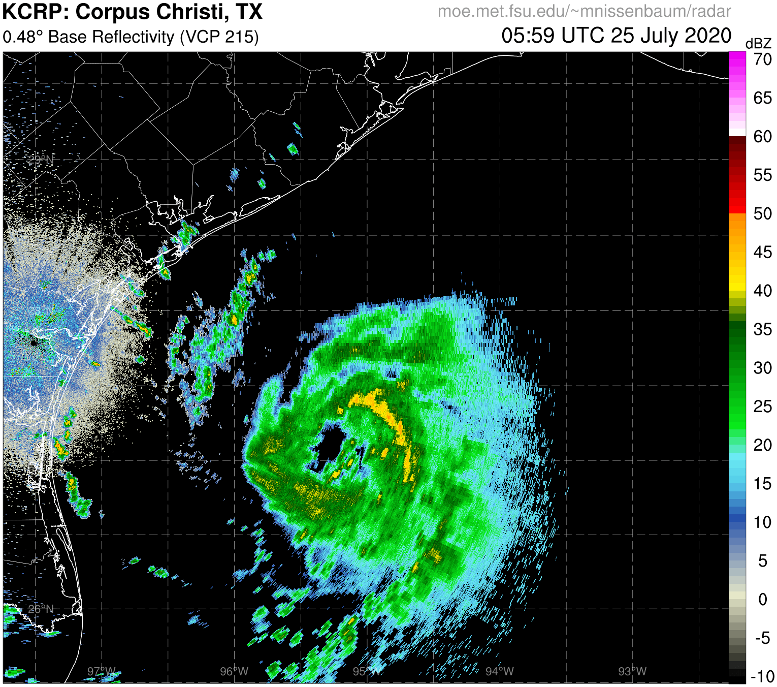
Tight cumulus spin becoming evident.
3 likes   

User avatar
GCANE
S2K Supporter
S2K Supporter
Posts: 11453
Joined: Mon Oct 22, 2007 8:03 am

Re: ATL: INVEST 90L - Discussion

#169 Postby GCANE » Thu Sep 17, 2020 2:58 pm

Looks like its spinning up with a big drop in CAPE.
Could be another cold-pool TC.
1 likes   

User avatar
chaser1
S2K Supporter
S2K Supporter
Posts: 5407
Age: 64
Joined: Sat Oct 15, 2005 5:59 pm
Location: Longwood, Fl

Re: ATL: INVEST 90L - Discussion

#170 Postby chaser1 » Thu Sep 17, 2020 2:59 pm

Just took a first look in about 5 hours :eek: This thing has got to be a T.D...... might be close to a T.S.! This has escalated a good deal today and what appeared as an elongated COC this morning, now appears to have developed a fairly tight LLC. I hadn't heard if recon will get there soon but if so, I'm pretty sure we'll have a T.D. at 5:00pm
4 likes   
Andy D

(For official information, please refer to the NHC and NWS products.)

User avatar
lrak
S2K Supporter
S2K Supporter
Posts: 1770
Age: 58
Joined: Thu Jun 21, 2007 2:48 pm
Location: Corpus Christi, TX

Re: ATL: INVEST 90L - Discussion

#171 Postby lrak » Thu Sep 17, 2020 3:08 pm

I think I'm developing "chronic hurricane syndrome" or CHS. Hopefully my doctor will prescribe some drugs.
7 likes   
AKA karl

Also
Personal Forecast Disclaimer:
My posts on this forum are NOT official forecast and should not be used as such. My posts are my basic observations and are definitely not backed by any "well some" meteorological knowledge. For official information, please refer to the NHC and NWS products.

User avatar
Blinhart
Category 5
Category 5
Posts: 2079
Age: 48
Joined: Thu Sep 08, 2011 3:13 pm
Location: Crowley, La.

Re: ATL: INVEST 90L - Discussion

#172 Postby Blinhart » Thu Sep 17, 2020 3:09 pm

So this cool front that's coming down and stall over the Gulf Coast is going to be the deciding factor I guess.
0 likes   
Personal Forecast Disclaimer:
The posts in this forum are NOT official forecast and should not be used as such. They are just the opinion of the poster and may or may not be backed by sound meteorological data. They are NOT endorsed by any professional institution or storm2k.org. For official information, please refer to the NHC and NWS products.

User avatar
aspen
Category 5
Category 5
Posts: 8812
Joined: Sat Oct 12, 2019 7:10 pm
Location: Connecticut, USA

Re: ATL: INVEST 90L - Discussion

#173 Postby aspen » Thu Sep 17, 2020 3:09 pm

The fact that 90L/Wilfred will be stuck in the Gulf for days, meandering over 30-31C SSTs with <910 mbar MPIs and higher OHC than Sally means that despite the potential for dry air, I’m not excluding the possibility of this making a run for major hurricane intensity sometime during its life.
9 likes   
Irene '11 Sandy '12 Hermine '16 5/15/2018 Derecho Fay '20 Isaias '20 Elsa '21 Henri '21 Ida '21

I am only a meteorology enthusiast who knows a decent amount about tropical cyclones. Look to the professional mets, the NHC, or your local weather office for the best information.

User avatar
ScottNAtlanta
Category 5
Category 5
Posts: 2360
Joined: Sat May 25, 2013 3:11 pm
Location: Atlanta, GA

Re: ATL: INVEST 90L - Discussion

#174 Postby ScottNAtlanta » Thu Sep 17, 2020 3:19 pm

The only areas that dont have wake left from Laura or Sally. It sure looks like at least a depression to me.
0 likes   
The posts in this forum are NOT official forecast and should not be used as such. They are just the opinion of the poster and may or may not be backed by sound meteorological data. They are NOT endorsed by any professional institution or storm2k.org. For official information, please refer to the NHC and NWS products.

User avatar
northjaxpro
S2K Supporter
S2K Supporter
Posts: 8900
Joined: Mon Sep 27, 2010 11:21 am
Location: Jacksonville, FL

Re: ATL: INVEST 90L - Discussion

#175 Postby northjaxpro » Thu Sep 17, 2020 3:21 pm

ScottNAtlanta wrote:The only areas that dont have wake left from Laura or Sally. It sure looks like at least a depression to me.


It may be a low end Tropical Storm Wilfred when Recon gets in there, which should be shortly.
0 likes   
NEVER, EVER SAY NEVER in the tropics and weather in general, and most importantly, with life itself!!

________________________________________________________________________________________

Fay 2008 Beryl 2012 Debby 2012 Colin 2016 Hermine 2016 Julia 2016 Matthew 2016 Irma 2017 Dorian 2019

User avatar
HurricaneAndre2008
Category 1
Category 1
Posts: 327
Age: 27
Joined: Wed Jul 31, 2019 9:51 pm
Contact:

Re: ATL: INVEST 90L - Discussion

#176 Postby HurricaneAndre2008 » Thu Sep 17, 2020 3:27 pm

Looks like no new cyclone at 5pm
0 likes   
Cindy(2005), Katrina(2005), Rita(2005), Erin(2007), Isaac(2012)

hurricanehunter69
Category 1
Category 1
Posts: 342
Joined: Sun May 16, 2010 5:21 pm
Location: New Orleans

Re: ATL: INVEST 90L - Discussion

#177 Postby hurricanehunter69 » Thu Sep 17, 2020 3:35 pm

Check out the dry air moving in from the west. That air should moisten up and saturate with water in short order. Also, notice how everything is streaming off to the north/north east. I'd bet on future Wilfred paying a visit to the north gulf coast.https://weather.cod.edu/satrad/?parms=r ... =undefined
0 likes   

User avatar
HurricaneAndre2008
Category 1
Category 1
Posts: 327
Age: 27
Joined: Wed Jul 31, 2019 9:51 pm
Contact:

Re: ATL: INVEST 90L - Discussion

#178 Postby HurricaneAndre2008 » Thu Sep 17, 2020 3:39 pm

1006.0 mb
(~ 29.71 inHg)
1 likes   
Cindy(2005), Katrina(2005), Rita(2005), Erin(2007), Isaac(2012)

User avatar
wxman57
Moderator-Pro Met
Moderator-Pro Met
Posts: 22951
Age: 67
Joined: Sat Jun 21, 2003 8:06 pm
Location: Houston, TX (southwest)

Re: ATL: INVEST 90L - Discussion

#179 Postby wxman57 » Thu Sep 17, 2020 3:42 pm

Got my cast off this afternoon - only a wrist brace. The titanium has fused with my skeleton to make me extra strong. As for 90L, there is much uncertainty in its long-term future. Models agree it will move steadily northward for 2-3 days then run into weak steering currents. During that 2-3 days, it will be ingesting a lot of dry air from behind the front. It may even merge with the front for a while. However, by early next week, the frontal boundary will be dissipating, allowing for strengthening. General thinking is a drift westward toward the lower to middle Texas coast early next week. Big question is - does it just continue moving west and inland into TX Tuesday, as per the GFS? Does it only approach the TX coast then stall,waiting for a passing trof to the north to pick it up and steer it NE (Euro, ICON)? UKMET takes it to the coast of MX south of Brownsville next Tue/Wed and stalls it. It did very well with Sally.

I have it moving toward TX Mon/Tue, dipping SW then turning E-ENE Wed-Thu (70kt hurricane at day 7). Would rather it just move inland into south TX or Mexico early next week. That could happen...
14 likes   

User avatar
northjaxpro
S2K Supporter
S2K Supporter
Posts: 8900
Joined: Mon Sep 27, 2010 11:21 am
Location: Jacksonville, FL

Re: ATL: INVEST 90L - Discussion

#180 Postby northjaxpro » Thu Sep 17, 2020 3:46 pm

wxman57 wrote:Got my cast off this afternoon - only a wrist brace. The titanium has fused with my skeleton to make me extra strong. As for 90L, there is much uncertainty in its long-term future. Models agree it will move steadily northward for 2-3 days then run into weak steering currents. During that 2-3 days, it will be ingesting a lot of dry air from behind the front. It may even merge with the front for a while. However, by early next week, the frontal boundary will be dissipating, allowing for strengthening. General thinking is a drift westward toward the lower to middle Texas coast early next week. Big question is - does it just continue moving west and inland into TX Tuesday, as per the GFS? Does it only approach the TX coast then stall,waiting for a passing trof to the north to pick it up and steer it NE (Euro, ICON)? UKMET takes it to the coast of MX south of Brownsville next Tue/Wed and stalls it. It did very well with Sally.

I have it moving toward TX Mon/Tue, dipping SW then turning E-ENE Wed-Thu (70kt hurricane at day 7). Would rather it just move inland into south TX or Mexico early next week. That could happen...


Great news about your wrist 57. It appears you are recovering well!

Yeah, this system will give us all migraines in the days to come unfortunately meandering arounnd in the GOM.
Last edited by northjaxpro on Thu Sep 17, 2020 3:46 pm, edited 1 time in total.
0 likes   
NEVER, EVER SAY NEVER in the tropics and weather in general, and most importantly, with life itself!!

________________________________________________________________________________________

Fay 2008 Beryl 2012 Debby 2012 Colin 2016 Hermine 2016 Julia 2016 Matthew 2016 Irma 2017 Dorian 2019


Return to “2020”

Who is online

Users browsing this forum: No registered users and 43 guests