2020 Global Model Runs Discussion (Out thru day 16)

This is the general tropical discussion area. Anyone can take their shot at predicting a storms path.

Moderator: S2k Moderators

Forum rules

The posts in this forum are NOT official forecasts and should not be used as such. They are just the opinion of the poster and may or may not be backed by sound meteorological data. They are NOT endorsed by any professional institution or STORM2K. For official information, please refer to products from the National Hurricane Center and National Weather Service.

Help Support Storm2K
Message
Author
User avatar
Hurricaneman
Category 5
Category 5
Posts: 7351
Age: 45
Joined: Tue Aug 31, 2004 3:24 pm
Location: central florida

Re: 2020 Global Model Runs Discussion (Out thru day 16)

#2381 Postby Hurricaneman » Mon Sep 21, 2020 11:28 am

gfsperpendicular wrote:
toad strangler wrote:
SouthFLTropics wrote:Explodes on that GFS-Para is an understatement. It drops over 20mb in just 6 hours. :double:

I know this is long range, but the fact that the GFS and GFS Para along with their ensembles and with some signals from the EPS ensembles, is enough in my opinion to believe that this won't be just another phantom.


Damn, another level headed dude on board. I'm not there yet. This needs to start moving up consistently on the GFS. With a SEEMINGLY traceable spark, it should be doing that.


It is. The time frame has been Oct 3-4 every single run. That GFS-Para run has a TD potentially under 300 hours. We'll see if it starts showing up on the Euro and others in a few days.


The GFS and GFS para have this feature coming off of Africa tomorrow, enters the Caribbean by day 9 and starts development by day 12 in the western Caribbean so while its in fantasy range it’s not a phantom as there is a feature currently on the map that is the impetus for development
0 likes   

User avatar
StPeteMike
Category 2
Category 2
Posts: 633
Joined: Thu Jun 07, 2018 11:26 pm

Re: 2020 Global Model Runs Discussion (Out thru day 16)

#2382 Postby StPeteMike » Mon Sep 21, 2020 11:29 am

I think it’s safe to say it’s something to definitely watch, since there seems to be a consensus on development. There’s less certainty on direction though, with some forecasting a strong ridge and putting this through the Yucatán and then others bringing it north.
0 likes   
The above post is not official and should not be used as such. It is the opinion of the poster and may or may not be backed by sound meteorological data. It is not endorsed by any professional institution or storm2k.org. For official information, please refer to the NHC and NWS products.

User avatar
SFLcane
S2K Supporter
S2K Supporter
Posts: 10163
Age: 47
Joined: Sat Jun 05, 2010 1:44 pm
Location: Lake Worth Florida

Re: 2020 Global Model Runs Discussion (Out thru day 16)

#2383 Postby SFLcane » Mon Sep 21, 2020 11:29 am

gfsperpendicular wrote:
toad strangler wrote:
SouthFLTropics wrote:Explodes on that GFS-Para is an understatement. It drops over 20mb in just 6 hours. :double:

I know this is long range, but the fact that the GFS and GFS Para along with their ensembles and with some signals from the EPS ensembles, is enough in my opinion to believe that this won't be just another phantom.


Damn, another level headed dude on board. I'm not there yet. This needs to start moving up consistently on the GFS. With a SEEMINGLY traceable spark, it should be doing that.


It is. The time frame has been Oct 3-4 every single run. That GFS-Para run has a TD potentially under 300 hours. We'll see if it starts showing up on the Euro and others in a few days.


Starts to develop around 280hrs..

Image
0 likes   

User avatar
toad strangler
S2K Supporter
S2K Supporter
Posts: 4543
Joined: Sun Jul 28, 2013 3:09 pm
Location: Earth
Contact:

Re: 2020 Global Model Runs Discussion (Out thru day 16)

#2384 Postby toad strangler » Mon Sep 21, 2020 11:35 am

gfsperpendicular wrote:
toad strangler wrote:
SouthFLTropics wrote:Explodes on that GFS-Para is an understatement. It drops over 20mb in just 6 hours. :double:

I know this is long range, but the fact that the GFS and GFS Para along with their ensembles and with some signals from the EPS ensembles, is enough in my opinion to believe that this won't be just another phantom.


Damn, another level headed dude on board. I'm not there yet. This needs to start moving up consistently on the GFS. With a SEEMINGLY traceable spark, it should be doing that.


It is. The time frame has been Oct 3-4 every single run. That GFS-Para run has a TD potentially under 300 hours. We'll see if it starts showing up on the Euro and others in a few days.


Disagree. 12z FRIDAY had this in S FL on 10/4
12z SUNDAY had this near the Yucatan on 10/6
6z MONDAY this morning and it's Yucatan 10/7

It's getting pushed back.
0 likes   

User avatar
aspen
Category 5
Category 5
Posts: 8819
Joined: Sat Oct 12, 2019 7:10 pm
Location: Connecticut, USA

Re: 2020 Global Model Runs Discussion (Out thru day 16)

#2385 Postby aspen » Mon Sep 21, 2020 11:36 am

SFLcane wrote:
gfsperpendicular wrote:
toad strangler wrote:
Damn, another level headed dude on board. I'm not there yet. This needs to start moving up consistently on the GFS. With a SEEMINGLY traceable spark, it should be doing that.


It is. The time frame has been Oct 3-4 every single run. That GFS-Para run has a TD potentially under 300 hours. We'll see if it starts showing up on the Euro and others in a few days.


Starts to develop around 280hrs..

https://i.imgur.com/dsWwFYY.gif

There’s some vorticity around the southern Leeward Islands as early as 234 hours, which later develops into this system.
0 likes   
Irene '11 Sandy '12 Hermine '16 5/15/2018 Derecho Fay '20 Isaias '20 Elsa '21 Henri '21 Ida '21

I am only a meteorology enthusiast who knows a decent amount about tropical cyclones. Look to the professional mets, the NHC, or your local weather office for the best information.

User avatar
CyclonicFury
Category 5
Category 5
Posts: 2026
Age: 26
Joined: Sun Jul 02, 2017 12:32 pm
Location: NC
Contact:

Re: 2020 Global Model Runs Discussion (Out thru day 16)

#2386 Postby CyclonicFury » Mon Sep 21, 2020 11:39 am

If the GFS was right we'd have several major hurricanes in the NW Caribbean every year. We haven't had a major hurricane in the NW Caribbean since 2011.
0 likes   
NCSU B.S. in Meteorology Class of 2021. Tropical weather blogger at http://www.cyclonicfury.com. My forecasts and thoughts are NOT official, for official forecasts please consult the National Hurricane Center.

User avatar
SFLcane
S2K Supporter
S2K Supporter
Posts: 10163
Age: 47
Joined: Sat Jun 05, 2010 1:44 pm
Location: Lake Worth Florida

Re: 2020 Global Model Runs Discussion (Out thru day 16)

#2387 Postby SFLcane » Mon Sep 21, 2020 11:40 am

Image
0 likes   

User avatar
ElectricStorm
Category 5
Category 5
Posts: 5057
Age: 24
Joined: Tue Aug 13, 2019 11:23 pm
Location: Skiatook, OK / Norman, OK

Re: 2020 Global Model Runs Discussion (Out thru day 16)

#2388 Postby ElectricStorm » Mon Sep 21, 2020 11:42 am


That's pretty low latitude. We'll see if this wave manages to stay that far south.
0 likes   
B.S Meteorology, University of Oklahoma '25

Please refer to the NHC, NWS, or SPC for official information.

User avatar
aspen
Category 5
Category 5
Posts: 8819
Joined: Sat Oct 12, 2019 7:10 pm
Location: Connecticut, USA

Re: 2020 Global Model Runs Discussion (Out thru day 16)

#2389 Postby aspen » Mon Sep 21, 2020 11:55 am

Image
Image
Image

The important thing is that we're able to locate a source within 240 hours, and it appears to be one of the AEWs that'll exit the coast within the next 3-5 days. The GFS has the ridge build back by the time this wave is trekking across the eastern to central MDR next week, pushing it right into the Caribbean. I think we'll need to keep an eye out on every low-latitude wave for the next several days if the ridge really does build back and prevents them from heading north like Teddy and Wilfred.
1 likes   
Irene '11 Sandy '12 Hermine '16 5/15/2018 Derecho Fay '20 Isaias '20 Elsa '21 Henri '21 Ida '21

I am only a meteorology enthusiast who knows a decent amount about tropical cyclones. Look to the professional mets, the NHC, or your local weather office for the best information.

User avatar
HeeBGBz
Category 1
Category 1
Posts: 341
Age: 71
Joined: Sun Sep 03, 2006 3:25 pm
Location: Biloxi, MS

Re: 2020 Global Model Runs Discussion (Out thru day 16)

#2390 Postby HeeBGBz » Mon Sep 21, 2020 12:08 pm

Is the weather crossing the tip of Florida something that needs to be watched? :double:
0 likes   

LarryWx
S2K Supporter
S2K Supporter
Posts: 6346
Joined: Sun Sep 07, 2003 2:04 pm
Location: GA

Re: 2020 Global Model Runs Discussion (Out thru day 16)

#2391 Postby LarryWx » Mon Sep 21, 2020 12:08 pm

I agree that the GFS is terrible in the Caribbean. But climo (weak to moderate La Niña following a weak to moderate El Niño) says the Caribbean will bear watching in early to mid Oct. The GFS may be showing a phantom like it often does, but at some point in early to mid Oct something is likely going to get going whether it be around 10/4 or later.
1 likes   
Personal Forecast Disclaimer:
The posts in this forum are NOT official forecasts and should not be used as such. They are just the opinion of the poster and may or may not be backed by sound meteorological data. They are NOT endorsed by any professional institution or storm2k.org. For official information, please refer to the NHC and NWS products.

User avatar
StPeteMike
Category 2
Category 2
Posts: 633
Joined: Thu Jun 07, 2018 11:26 pm

Re: 2020 Global Model Runs Discussion (Out thru day 16)

#2392 Postby StPeteMike » Mon Sep 21, 2020 12:13 pm

HeeBGBz wrote:Is the weather crossing the tip of Florida something that needs to be watched? :double:

I don’t believe it will. It has a very limited time to spin up anything and would have to do so now or the next couple days. The fact that no models really have support for something developing in the short term can assure me nothing will come out except breezy conditions and rain.
0 likes   
The above post is not official and should not be used as such. It is the opinion of the poster and may or may not be backed by sound meteorological data. It is not endorsed by any professional institution or storm2k.org. For official information, please refer to the NHC and NWS products.

User avatar
ElectricStorm
Category 5
Category 5
Posts: 5057
Age: 24
Joined: Tue Aug 13, 2019 11:23 pm
Location: Skiatook, OK / Norman, OK

Re: 2020 Global Model Runs Discussion (Out thru day 16)

#2393 Postby ElectricStorm » Mon Sep 21, 2020 12:17 pm

StPeteMike wrote:
HeeBGBz wrote:Is the weather crossing the tip of Florida something that needs to be watched? :double:

I don’t believe it will. It has a very limited time to spin up anything and would have to do so now or the next couple days. The fact that no models really have support for something developing in the short term can assure me nothing will come out except breezy conditions and rain.

I would agree with this but there are a few reasons it could pull a quick one on us
1) The models have been awful this year at sniffing out development
2) Pretty much every disturbance this year has found a way to spin up somehow... Only a few haven't
3) It's 2020
3 likes   
B.S Meteorology, University of Oklahoma '25

Please refer to the NHC, NWS, or SPC for official information.

User avatar
cheezyWXguy
Category 5
Category 5
Posts: 6108
Joined: Mon Feb 13, 2006 12:29 am
Location: Dallas, TX

Re: 2020 Global Model Runs Discussion (Out thru day 16)

#2394 Postby cheezyWXguy » Mon Sep 21, 2020 12:20 pm

12z showing similar development as 06z but much weaker due to more land interaction. I’m still on the fence here too. There is an area of vorticity that can be tracked to a wave that exits in Africa in a day or so, but it should be noted that the phantom back in August showed this too. It is unclear to me whether the wave is the source of development, a trigger to an existing CAG feature, or the CAG itself, again similar to the August phantom.

The difference in my opinion between August and now, is that showing this pattern back then made no sense. Climatology suggests that if something like this were to happen, the timeframe depicted is when it would happen. So far, we have what may be a trigger, a reasonable pattern, and climo backing. As a result, I would put my confidence in this setup a little higher than the August phantom (which should suggest my confidence is low) but I remain skeptical until full-fledged development gets into the 8-10 day range at earliest.
0 likes   

User avatar
chris_fit
Category 5
Category 5
Posts: 3222
Age: 42
Joined: Wed Sep 10, 2003 11:58 pm
Location: Tampa Bay Area, FL

Re: 2020 Global Model Runs Discussion (Out thru day 16)

#2395 Postby chris_fit » Mon Sep 21, 2020 12:23 pm

12Z GFS ENS, continuing to show activity in the SW Carib in about 10 days.
0 likes   

User avatar
gatorcane
S2K Supporter
S2K Supporter
Posts: 23692
Age: 47
Joined: Sun Mar 13, 2005 3:54 pm
Location: Boca Raton, FL

Re: 2020 Global Model Runs Discussion (Out thru day 16)

#2396 Postby gatorcane » Mon Sep 21, 2020 12:39 pm

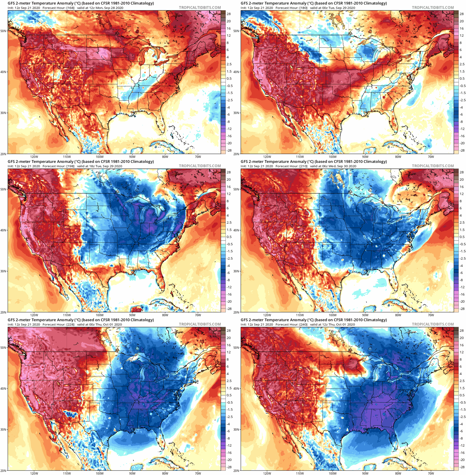
Both the GFS and Euro are showing quite the front that swings through the SE CONUS and GOM in the 8-10 day timeframe. Such a front could yank something out of the SW Caribbean northward but these fronts also should start gradually cooling the SSTs in the Gulf and even some around Florida.

Saved GFS animation:

Image
1 likes   

User avatar
StPeteMike
Category 2
Category 2
Posts: 633
Joined: Thu Jun 07, 2018 11:26 pm

Re: 2020 Global Model Runs Discussion (Out thru day 16)

#2397 Postby StPeteMike » Mon Sep 21, 2020 12:40 pm

Weather Dude wrote:
StPeteMike wrote:
HeeBGBz wrote:Is the weather crossing the tip of Florida something that needs to be watched? :double:

I don’t believe it will. It has a very limited time to spin up anything and would have to do so now or the next couple days. The fact that no models really have support for something developing in the short term can assure me nothing will come out except breezy conditions and rain.

I would agree with this but there are a few reasons it could pull a quick one on us
1) The models have been awful this year at sniffing out development
2) Pretty much every disturbance this year has found a way to spin up somehow... Only a few haven't
3) It's 2020

Models have genuinely been bad with long term development. Will say though, they really failed with Sally when it comes to short term. If the environment was the same as when Sally was around, I would agree. We shall see though.
0 likes   
The above post is not official and should not be used as such. It is the opinion of the poster and may or may not be backed by sound meteorological data. It is not endorsed by any professional institution or storm2k.org. For official information, please refer to the NHC and NWS products.

User avatar
StPeteMike
Category 2
Category 2
Posts: 633
Joined: Thu Jun 07, 2018 11:26 pm

Re: 2020 Global Model Runs Discussion (Out thru day 16)

#2398 Postby StPeteMike » Mon Sep 21, 2020 12:41 pm

gatorcane wrote:Both the GFS and Euro are showing quite the front that swings through the SE CONUS and GOM in the 8-10 day timeframe. Such a front could yank something out of the SW Caribbean northward but these fronts also should start gradually cooling the SSTs in the Gulf and even some around Florida.

Saved GFS animation:

https://i.postimg.cc/zG6Tw8jV/gfs-T2ma-us-fh168-240.gif

What model was showing a cold blast last week? :lol:
1 likes   
The above post is not official and should not be used as such. It is the opinion of the poster and may or may not be backed by sound meteorological data. It is not endorsed by any professional institution or storm2k.org. For official information, please refer to the NHC and NWS products.

User avatar
toad strangler
S2K Supporter
S2K Supporter
Posts: 4543
Joined: Sun Jul 28, 2013 3:09 pm
Location: Earth
Contact:

Re: 2020 Global Model Runs Discussion (Out thru day 16)

#2399 Postby toad strangler » Mon Sep 21, 2020 12:57 pm

chris_fit wrote:12Z GFS ENS, continuing to show activity in the SW Carib in about 10 days.


Yeah, and 10 days from now it will be 10 days out 8-)
0 likes   

User avatar
DestinHurricane
Category 4
Category 4
Posts: 935
Joined: Tue May 01, 2018 8:05 am
Location: New York, NY

Re: 2020 Global Model Runs Discussion (Out thru day 16)

#2400 Postby DestinHurricane » Mon Sep 21, 2020 1:09 pm

It's an AEW coming off Africa that the models are showing in the Caribbean, not a phantom. Should we start a thread about this wave?
2 likes   
Michael 2018


Return to “Talkin' Tropics”

Who is online

Users browsing this forum: Blown Away, LarryWx, TomballEd, Ulf, zzzh and 76 guests