https://twitter.com/AndyHazelton/status/1317060874620882944
https://twitter.com/tropicalupdate/status/1317060763350159360
Trough of low pressure in Western Caribbean (Is Invest 95L)
Moderator: S2k Moderators
Forum rules

The posts in this forum are NOT official forecasts and should not be used as such. They are just the opinion of the poster and may or may not be backed by sound meteorological data. They are NOT endorsed by any professional institution or STORM2K. For official information, please refer to products from the National Hurricane Center and National Weather Service.
-
chris_fit

- Category 5

- Posts: 3261
- Age: 43
- Joined: Wed Sep 10, 2003 11:58 pm
- Location: Tampa Bay Area, FL
Re: Possible SW Caribbean Development
The mean GEFS for 06Z are, once again, well west, south, and slower than the operational. Yuck.

0 likes
-
cycloneye

- Admin

- Posts: 149436
- Age: 69
- Joined: Thu Oct 10, 2002 10:54 am
- Location: San Juan, Puerto Rico
Re: Possible SW Caribbean Development
A broad area of low pressure is expected to form early next week
over the southwestern Caribbean Sea. Some gradual development of
this system will be possible through the middle of next week while
it remains nearly stationary over the southwestern Caribbean Sea.
* Formation chance through 48 hours...low...near 0 percent.
* Formation chance through 5 days...low...30 percent
0 likes
Visit the Caribbean-Central America Weather Thread where you can find at first post web cams,radars
and observations from Caribbean basin members Click Here
and observations from Caribbean basin members Click Here
-
TheStormExpert

-
TheStormExpert
Re: Possible SW Caribbean Development
Maybe Hurricane Irene (1999) could be a good analog storm at least in terms of track?
I always had a funny feeling a track like this was more possible over a track like Wilma this season.
https://en.wikipedia.org/wiki/Hurricane_Irene_(1999)

I always had a funny feeling a track like this was more possible over a track like Wilma this season.
https://en.wikipedia.org/wiki/Hurricane_Irene_(1999)
Last edited by TheStormExpert on Fri Oct 16, 2020 6:49 am, edited 1 time in total.
5 likes

Re: Possible SW Caribbean Development
The GFS ensemble has been trending more ominous for Florida in the last 2 runs. The latest ensemble seems to be further west with 10/21 members directly making landfall on Florida as a TD or stronger (48%) within 300 hours.
Last edited by kevin on Fri Oct 16, 2020 6:50 am, edited 1 time in total.
3 likes
-
SFLcane

- S2K Supporter

- Posts: 10281
- Age: 48
- Joined: Sat Jun 05, 2010 1:44 pm
- Location: Lake Worth Florida
Re: Possible SW Caribbean Development
chris_fit wrote:The mean GEFS for 06Z are, once again, well west, south, and slower than the operational. Yuck.
https://i.imgur.com/JcdPx9s.png
Ouch!
0 likes
-
Shell Mound
- Category 5
- Posts: 2432
- Age: 33
- Joined: Thu Sep 07, 2017 3:39 pm
- Location: St. Petersburg, FL → Scandinavia
Re: Possible SW Caribbean Development
SFLcane wrote:chris_fit wrote:The mean GEFS for 06Z are, once again, well west, south, and slower than the operational. Yuck.
https://i.imgur.com/JcdPx9s.png
Ouch!
The good news is that the westerly members are weaker than the easterly ones, implying stronger shear. 06Z GEFS members are much weaker vs. earlier ones.
0 likes
CVW / MiamiensisWx / Shell Mound
The posts in this forum are NOT official forecasts and should not be used as such. They are just the opinion of the poster and may or may not be backed by sound meteorological data. They are NOT endorsed by any professional institution or STORM2K. For official information, please refer to products from the NHC and NWS.
-
SFLcane
- S2K Supporter
- Posts: 10281
- Age: 48
- Joined: Sat Jun 05, 2010 1:44 pm
- Location: Lake Worth Florida
Re: Possible SW Caribbean Development
Shell Mound wrote:SFLcane wrote:chris_fit wrote:The mean GEFS for 06Z are, once again, well west, south, and slower than the operational. Yuck.
https://i.imgur.com/JcdPx9s.png
Ouch!
The good news is that the westerly members are weaker than the easterly ones, implying stronger shear.
No sir...
There some potent hurricanes there. Can’t take away if this hold it’s getting quite ominous for FL.
0 likes
-
TheStormExpert
Re: Possible SW Caribbean Development
Lets see if the 12z GFS and GEFS holds firm or flips around again.

0 likes
-
SFLcane
- S2K Supporter
- Posts: 10281
- Age: 48
- Joined: Sat Jun 05, 2010 1:44 pm
- Location: Lake Worth Florida
Re: Possible SW Caribbean Development
TheStormExpert wrote:Lets see if the 12z GFS and GEFS holds firm or flips around again.
More shifting back and forth We'll finally get some better clarity next week. Should be interesting!
0 likes

Re: Possible SW Caribbean Development
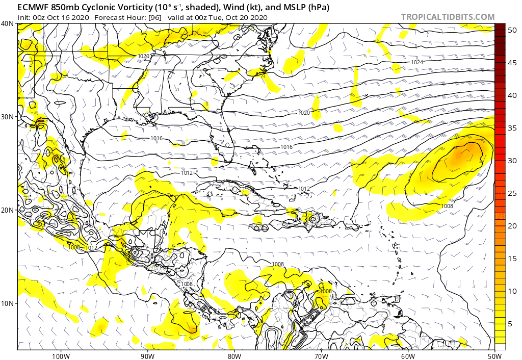
AJC3 wrote:N2FSU wrote:0z Euro +216
https://uploads.tapatalk-cdn.com/20201016/c827fa4bd82fb3b1f94a61e1d4d55ed2.jpg
Sent from my iPhone using Tapatalk
it still doesn't do much at all with the NW Caribbean disturbance, and instead develops a separate baroclinic low over the eastern GOMEX, which it takes rapidly NE to NNE through the SE CONUS.
Oh EURO...... ever so late to every party this season. Give 'er about another 72-96 hours and i'm guessing we'll begin to see it loudly pinging with an increasingly defined 850mb vorticity signature in the W. Caribbean.
1 likes
Andy D
(For official information, please refer to the NHC and NWS products.)
(For official information, please refer to the NHC and NWS products.)
-
Shell Mound
- Category 5
- Posts: 2432
- Age: 33
- Joined: Thu Sep 07, 2017 3:39 pm
- Location: St. Petersburg, FL → Scandinavia
Re: Possible SW Caribbean Development
SFLcane wrote:Shell Mound wrote:SFLcane wrote:
Ouch!
The good news is that the westerly members are weaker than the easterly ones, implying stronger shear.
No sir...
There some potent hurricanes there. Can’t take away if this hold it’s getting quite ominous for FL.
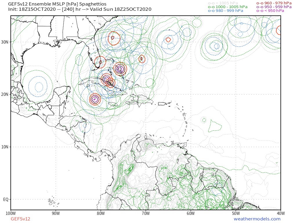
The most recent run (bottom) shows fewer members in the low 950s and more in the mid to upper 950s (mb). So there is a westward, weaker shift.
I’d be more concerned if the GEFS were showing a bunch of sub-950-mb cyclones heading into FL. Threat to FL is increasing, but not strength-wise.
0 likes
CVW / MiamiensisWx / Shell Mound
The posts in this forum are NOT official forecasts and should not be used as such. They are just the opinion of the poster and may or may not be backed by sound meteorological data. They are NOT endorsed by any professional institution or STORM2K. For official information, please refer to products from the NHC and NWS.
-
toad strangler

- S2K Supporter
- Posts: 4546
- Joined: Sun Jul 28, 2013 3:09 pm
- Location: Earth
- Contact:
Re: Possible SW Caribbean Development
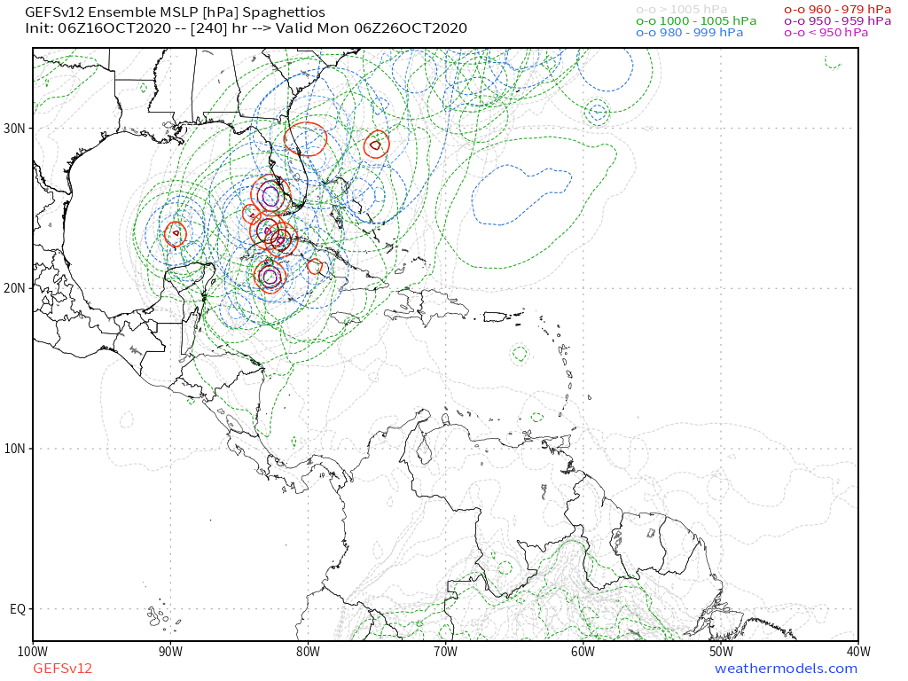
TheStormExpert wrote:GEFS has definitely trended west since the 00z run.
https://i.imgur.com/1MnCM9r.gif
Many of those members fall into the Herbert Box #2
2 likes
My Weather Station
https://www.wunderground.com/dashboard/pws/KFLPORTS603
https://www.wunderground.com/dashboard/pws/KFLPORTS603
-
TheStormExpert
Re: Possible SW Caribbean Development
Shell Mound wrote:SFLcane wrote:Shell Mound wrote:The good news is that the westerly members are weaker than the easterly ones, implying stronger shear.
No sir...
There some potent hurricanes there. Can’t take away if this hold it’s getting quite ominous for FL.
https://i.postimg.cc/FFgdc2Mk/090-CC96-B-154-E-46-A7-BA59-69-C9-ED7-E1-EEB.jpg
https://i.postimg.cc/tRfyS9sQ/38-D3-AFA2-D9-BD-43-AC-8-BF0-36-D3-AB5099-A8.png
The most recent run (bottom) shows fewer members in the low 950s and more in the mid to upper 950s (mb). So there is a westward, weaker shift.
I’d be more concerned if the GEFS were showing a bunch of sub-950-mb cyclones heading into FL. Threat to FL is increasing, but not strength-wise.
So you're saying a 950-960mb hurricane is not strong?
0 likes
-
toad strangler
- S2K Supporter
- Posts: 4546
- Joined: Sun Jul 28, 2013 3:09 pm
- Location: Earth
- Contact:
Re: Possible SW Caribbean Development
TheStormExpert wrote:Lets see if the 12z GFS and GEFS holds firm or flips around again.
There will be more changes for sure but we are now quietly slipping well under the 200 hr mark in regards to position of this in the Caribbean
Last edited by toad strangler on Fri Oct 16, 2020 7:24 am, edited 1 time in total.
0 likes
My Weather Station
https://www.wunderground.com/dashboard/pws/KFLPORTS603
https://www.wunderground.com/dashboard/pws/KFLPORTS603
-
Shell Mound
- Category 5
- Posts: 2432
- Age: 33
- Joined: Thu Sep 07, 2017 3:39 pm
- Location: St. Petersburg, FL → Scandinavia
Re: Possible SW Caribbean Development
TheStormExpert wrote:Shell Mound wrote:SFLcane wrote:
No sir...
There some potent hurricanes there. Can’t take away if this hold it’s getting quite ominous for FL.
https://i.postimg.cc/FFgdc2Mk/090-CC96-B-154-E-46-A7-BA59-69-C9-ED7-E1-EEB.jpg
https://i.postimg.cc/tRfyS9sQ/38-D3-AFA2-D9-BD-43-AC-8-BF0-36-D3-AB5099-A8.png
The most recent run (bottom) shows fewer members in the low 950s and more in the mid to upper 950s (mb). So there is a westward, weaker shift.
I’d be more concerned if the GEFS were showing a bunch of sub-950-mb cyclones heading into FL. Threat to FL is increasing, but not strength-wise.
So you're saying a 950-960mb hurricane is not strong?
No, but it’s much better than a Cat-4+ hitting FL, unless the system is large. I would be much more concerned if models were showing a Cat-4+.
0 likes
CVW / MiamiensisWx / Shell Mound
The posts in this forum are NOT official forecasts and should not be used as such. They are just the opinion of the poster and may or may not be backed by sound meteorological data. They are NOT endorsed by any professional institution or STORM2K. For official information, please refer to products from the NHC and NWS.
-
gatorcane

- S2K Supporter
- Posts: 23708
- Age: 48
- Joined: Sun Mar 13, 2005 3:54 pm
- Location: Boca Raton, FL
Re: Possible SW Caribbean Development
AJC3 wrote:N2FSU wrote:0z Euro +216
https://uploads.tapatalk-cdn.com/20201016/c827fa4bd82fb3b1f94a61e1d4d55ed2.jpg
Sent from my iPhone using Tapatalk
it still doesn't do much at all with the NW Caribbean disturbance, and instead develops a separate baroclinic low over the eastern GOMEX, which it takes rapidly NE to NNE through the SE CONUS.
Indeed the Euro doesn’t show much coming from the SW Caribbean low. You can track a weak area of vorticity which moves north then NE east of Florida.
On a side note, it shows a massive front dropping into the Gulf
Last edited by gatorcane on Fri Oct 16, 2020 7:26 am, edited 1 time in total.
0 likes
-
toad strangler
- S2K Supporter
- Posts: 4546
- Joined: Sun Jul 28, 2013 3:09 pm
- Location: Earth
- Contact:
Re: Possible SW Caribbean Development
Shell Mound wrote:TheStormExpert wrote:Shell Mound wrote:https://i.postimg.cc/FFgdc2Mk/090-CC96-B-154-E-46-A7-BA59-69-C9-ED7-E1-EEB.jpg
https://i.postimg.cc/tRfyS9sQ/38-D3-AFA2-D9-BD-43-AC-8-BF0-36-D3-AB5099-A8.png
The most recent run (bottom) shows fewer members in the low 950s and more in the mid to upper 950s (mb). So there is a westward, weaker shift.
I’d be more concerned if the GEFS were showing a bunch of sub-950-mb cyclones heading into FL. Threat to FL is increasing, but not strength-wise.
So you're saying a 950-960mb hurricane is not strong?
No, but it’s much better than a Cat-4+ hitting FL, unless the system is large. I would be much more concerned if models were showing a Cat-4+.
strength either way we all know is the weakest area of modeling.
4 likes
My Weather Station
https://www.wunderground.com/dashboard/pws/KFLPORTS603
https://www.wunderground.com/dashboard/pws/KFLPORTS603
Who is online
Users browsing this forum: No registered users and 87 guests