I didn't check in here after the 18z GFS run yesterday, because it was hash data and needed to be discarded. The 00z and 06z are back in line with previous runs that have trended a bit more eastward and weaker. The NHC apparently isn't too concerned at this point considering the casual wording of their TWO's, because slowly moving lows in the Western Caribbean at this time of year are common. Some form and some don't, but the model's don't know that and intensify any disturbance in the area.
Still, if something does form the most likely track for mid-late October is NNE...
Frank
Trough of low pressure in Western Caribbean (Is Invest 95L)
Moderator: S2k Moderators
Forum rules

The posts in this forum are NOT official forecasts and should not be used as such. They are just the opinion of the poster and may or may not be backed by sound meteorological data. They are NOT endorsed by any professional institution or STORM2K. For official information, please refer to products from the National Hurricane Center and National Weather Service.

Re: Possible SW Caribbean Development
Interesting that the Euro doesn't really retrograde 94L. It intensifies it but drifts in south, then stationary, then slowly N-NE. This allows more ridging to remain in place over the SW Atlantic. Indeed the Euro builds literally a thumb ridge oriented northwest/southeast east of Florida at 500 mb before the trough sweeps in from the NW. This is what ACJ3 our east Florida resident MET was describing in an earlier post about these systems not retrograding as fast as some models depict. So lots of moving parts here still in a forecast more than a week away.
6 likes
-
ElectricStorm

- Category 5

- Posts: 5146
- Age: 25
- Joined: Tue Aug 13, 2019 11:23 pm
- Location: Norman, OK
Re: Possible SW Caribbean Development
Frank2 wrote:I didn't check in here after the 18z GFS run yesterday, because it was hash data and needed to be discarded. The 00z and 06z are back in line with previous runs that have trended a bit more eastward and weaker. The NHC apparently isn't too concerned at this point considering the casual wording of their TWO's, because slowly moving lows in the Western Caribbean at this time of year are common. Some form and some don't, but the model's don't know that and intensify any disturbance in the area.
Still, if something does form the most likely track for mid-late October is NNE...
Frank
Yeah but the 0z run wasn't weaker, it just didn't landfall in Florida. It's really gonna do what it's boss 94L tells it to do lol
0 likes
B.S Meteorology, University of Oklahoma '25
Please refer to the NHC, NWS, or SPC for official information.
Please refer to the NHC, NWS, or SPC for official information.

Re: Possible SW Caribbean Development
Until Zeta’s precursor forms on Monday, it’s going to be a back-and-forth between a late season slop storm and a exploding major hurricane. At least there’s more agreement on the track, though.
0 likes
Irene '11 Sandy '12 Hermine '16 5/15/2018 Derecho Fay '20 Isaias '20 Elsa '21 Henri '21 Ida '21
I am only a meteorology enthusiast who knows a decent amount about tropical cyclones. Look to the professional mets, the NHC, or your local weather office for the best information.
I am only a meteorology enthusiast who knows a decent amount about tropical cyclones. Look to the professional mets, the NHC, or your local weather office for the best information.
-
SFLcane

- S2K Supporter

- Posts: 10281
- Age: 48
- Joined: Sat Jun 05, 2010 1:44 pm
- Location: Lake Worth Florida
Re: Possible SW Caribbean Development
Definitely have to wait until the broad low forms before we can get a better idea we’re this is going to track.
1 likes
-
GeneratorPower

- S2K Supporter
- Posts: 1648
- Age: 46
- Joined: Sun Dec 18, 2005 11:48 pm
- Location: Huntsville, AL
Re: Possible SW Caribbean Development
SFLcane wrote:Definitely have to wait until the broad low forms before we can get a better idea we’re this is going to track.
I’ll still be watching it and things can change. But I’ve seen enough. Moderate slopgyre moving over Cuba and northeast through Bahamas. That’s my final answer.
0 likes
Re: Possible SW Caribbean Development
GeneratorPower wrote:SFLcane wrote:Definitely have to wait until the broad low forms before we can get a better idea we’re this is going to track.
I’ll still be watching it and things can change. But I’ve seen enough. Moderate slopgyre moving over Cuba and northeast through Bahamas. That’s my final answer.
You have one lifeline left...phone a friend:)
0 likes
-
SFLcane
- S2K Supporter
- Posts: 10281
- Age: 48
- Joined: Sat Jun 05, 2010 1:44 pm
- Location: Lake Worth Florida
Re: Possible SW Caribbean Development
GEFS This morning... just to close to call trying to figure we’re this low if any will form.

0 likes
Re: Possible SW Caribbean Development
But even that graphic shows a loosely-organized mess moving NNE.
Thinking back to Wilma, everyone was impressed at the large circulation several days before it consolidated, and knew if it did it would be a powerful system. Right now there is nothing there that comes close to what we were seeing 15 years ago...
Thinking back to Wilma, everyone was impressed at the large circulation several days before it consolidated, and knew if it did it would be a powerful system. Right now there is nothing there that comes close to what we were seeing 15 years ago...
1 likes
Re: Possible SW Caribbean Development
Zeta and its disturbance will have up to six days in the Caribbean, and said disturbance is still 2 days out from forming. A lot can change, but given the WCar’s track record this year of rapid intensification, there’s a decent chance Zeta will go bonkers if given the opportunity.
0 likes
Irene '11 Sandy '12 Hermine '16 5/15/2018 Derecho Fay '20 Isaias '20 Elsa '21 Henri '21 Ida '21
I am only a meteorology enthusiast who knows a decent amount about tropical cyclones. Look to the professional mets, the NHC, or your local weather office for the best information.
I am only a meteorology enthusiast who knows a decent amount about tropical cyclones. Look to the professional mets, the NHC, or your local weather office for the best information.
-
SFLcane
- S2K Supporter
- Posts: 10281
- Age: 48
- Joined: Sat Jun 05, 2010 1:44 pm
- Location: Lake Worth Florida
Re: Possible SW Caribbean Development
Frank2 wrote:But even that graphic shows a loosely-organized mess moving NNE.
Thinking back to Wilma, everyone was impressed at the large circulation several days before it consolidated, and knew if it did it would be a powerful system. Right now there is nothing there that comes close to what we were seeing 15 years ago...
No sir... the red circles rings are all potentially strong hurricanes shown by the gfs ensembles. Ultimate Location is anyone’s guess.
2 likes
-
Spacecoast

- Category 2

- Posts: 773
- Joined: Thu Aug 31, 2017 2:03 pm
Re: Possible SW Caribbean Development
SFLcane wrote:Frank2 wrote:But even that graphic shows a loosely-organized mess moving NNE.
Thinking back to Wilma, everyone was impressed at the large circulation several days before it consolidated, and knew if it did it would be a powerful system. Right now there is nothing there that comes close to what we were seeing 15 years ago...
No sir... the red circles rings are all potentially strong hurricanes shown by the gfs ensembles. Ultimate Location is anyone’s guess.
The red circles have a normalize spread of greater than 2.4, which means that the ultimate intensity,(and location) is anyone's guess,including the GEFS members.
0 likes
-
otowntiger
- Category 5
- Posts: 1932
- Joined: Tue Aug 31, 2004 7:06 pm
Re: Possible SW Caribbean Development
thanks Frank. My sentiments exactly, although I would add late October movement is typically NNE- NE.Frank2 wrote:I didn't check in here after the 18z GFS run yesterday, because it was hash data and needed to be discarded. The 00z and 06z are back in line with previous runs that have trended a bit more eastward and weaker. The NHC apparently isn't too concerned at this point considering the casual wording of their TWO's, because slowly moving lows in the Western Caribbean at this time of year are common. Some form and some don't, but the model's don't know that and intensify any disturbance in the area.
Still, if something does form the most likely track for mid-late October is NNE...
Frank
0 likes
Re: Possible SW Caribbean Development
Another day in the hopper/another lean to the right with that late season track up and out to the east...another reminder that Delta was likely FL's late season scare and it just got lost on the way. As always keep we keep checking in to make sure we remain on track...
0 likes
-
SFLcane
- S2K Supporter
- Posts: 10281
- Age: 48
- Joined: Sat Jun 05, 2010 1:44 pm
- Location: Lake Worth Florida
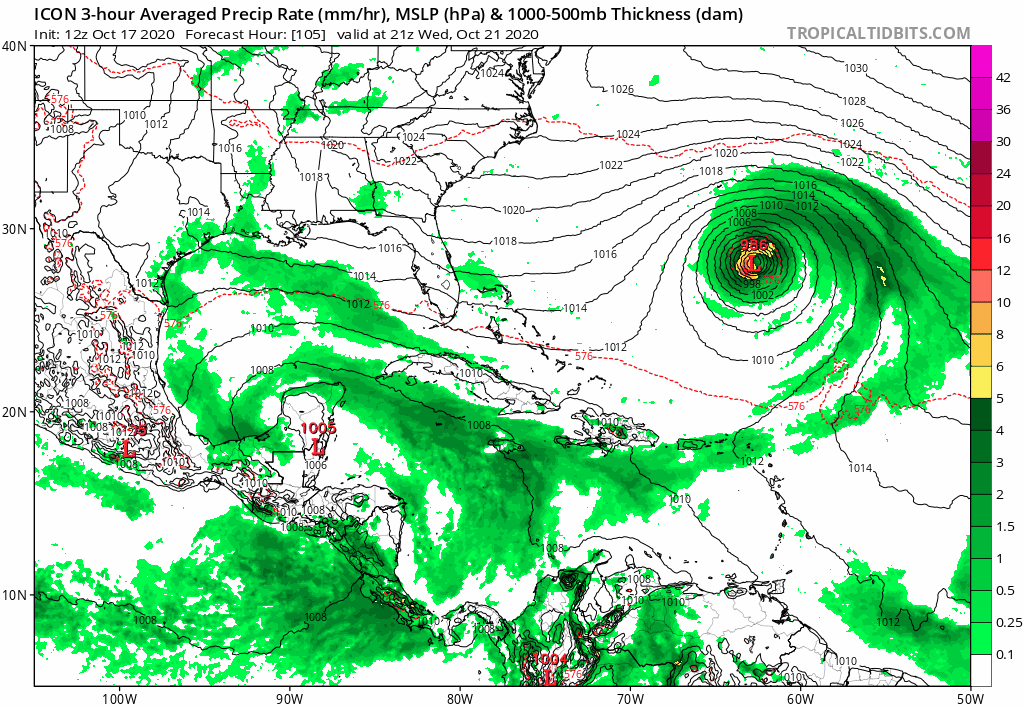
Re: Possible SW Caribbean Development
Icon finally coming around with Caribbean disturbance.
0 likes

Re: Possible SW Caribbean Development
SFLcane wrote:Icon finally coming around with Caribbean disturbance.
https://i.postimg.cc/TwXRKyk6/4450-BC4-A-DBBE-42-A6-A9-B7-B5-BAB8574804.gif
Yeah first time it develops from same origin of GFS. Before it was developing from vorticity of 93l.
0 likes
The following post is NOT an official forecast and should not be used as such. It is just the opinion of the poster and may or may not be backed by sound meteorological data. It is NOT endorsed by any professional institution including storm2k.org For Official Information please refer to the NHC and NWS products.
Re: Possible SW Caribbean Development
12z GFS takes a while trying to figure out where to concentrate the gyre’s vorticity.
0 likes
Irene '11 Sandy '12 Hermine '16 5/15/2018 Derecho Fay '20 Isaias '20 Elsa '21 Henri '21 Ida '21
I am only a meteorology enthusiast who knows a decent amount about tropical cyclones. Look to the professional mets, the NHC, or your local weather office for the best information.
I am only a meteorology enthusiast who knows a decent amount about tropical cyclones. Look to the professional mets, the NHC, or your local weather office for the best information.

Re: Possible SW Caribbean Development
I was going to cancel my trip to the Keys next weekend but I’m glad I didn’t but I’m not going to say all clear but all the models say Cuba and Bahamas as of today and I think they are nailing down the track since it hasn’t really changed the one time on the GFS18z which was trash. The GFS 12z looks like the same track.Thank you 94L.
Last edited by boca on Sat Oct 17, 2020 11:22 am, edited 2 times in total.
0 likes
-
SFLcane
- S2K Supporter
- Posts: 10281
- Age: 48
- Joined: Sat Jun 05, 2010 1:44 pm
- Location: Lake Worth Florida
Re: Possible SW Caribbean Development
boca wrote:I was going to cancel my trip to the Keys next weekend but I’m glad I didn’t but I’m not going to say all clear but all the models say Cuba and Bahamas as of today and I think they are nailing down to track since it hasn’t really changed the one time on the GFS18z which was trash.
94L ultimately saves the day. Big powerful hurricane there keeping the ridge from building. Enjoy your trip in the keys

0 likes
Who is online
Users browsing this forum: cycloneye, Google [Bot], South Texas Storms and 424 guests